
![Contains modified Copernicus Sentinel data [2019], processed by Sentinel Hub Barren Volcano, Barren Island, Andaman and Nicobar Islands, India](https://upload.wikimedia.org/wikipedia/commons/7/7a/Barren_Volcano%2C_Barren_Island%2C_Andaman_and_Nicobar_Islands%2C_India%E2%80%94Cropped.png?utm_source=commons.wikimedia.org&utm_campaign=imageinfo&utm_content=thumbnail_unscaled)
Contains modified Copernicus Sentinel data [2019], processed by Sentinel Hub Barren Volcano, Barren Island, Andaman and Nicobar Islands, India
Credit: SentinelHub · CC BY 2.0 · source

Pillow lava from Kamaʻehuakanaloa Seamount in Hawaii, USA. This sample is made of basalt and it was collected at 1180 metres below sea level.
Credit: Ed Shiinoki, NPS · Public domain · source
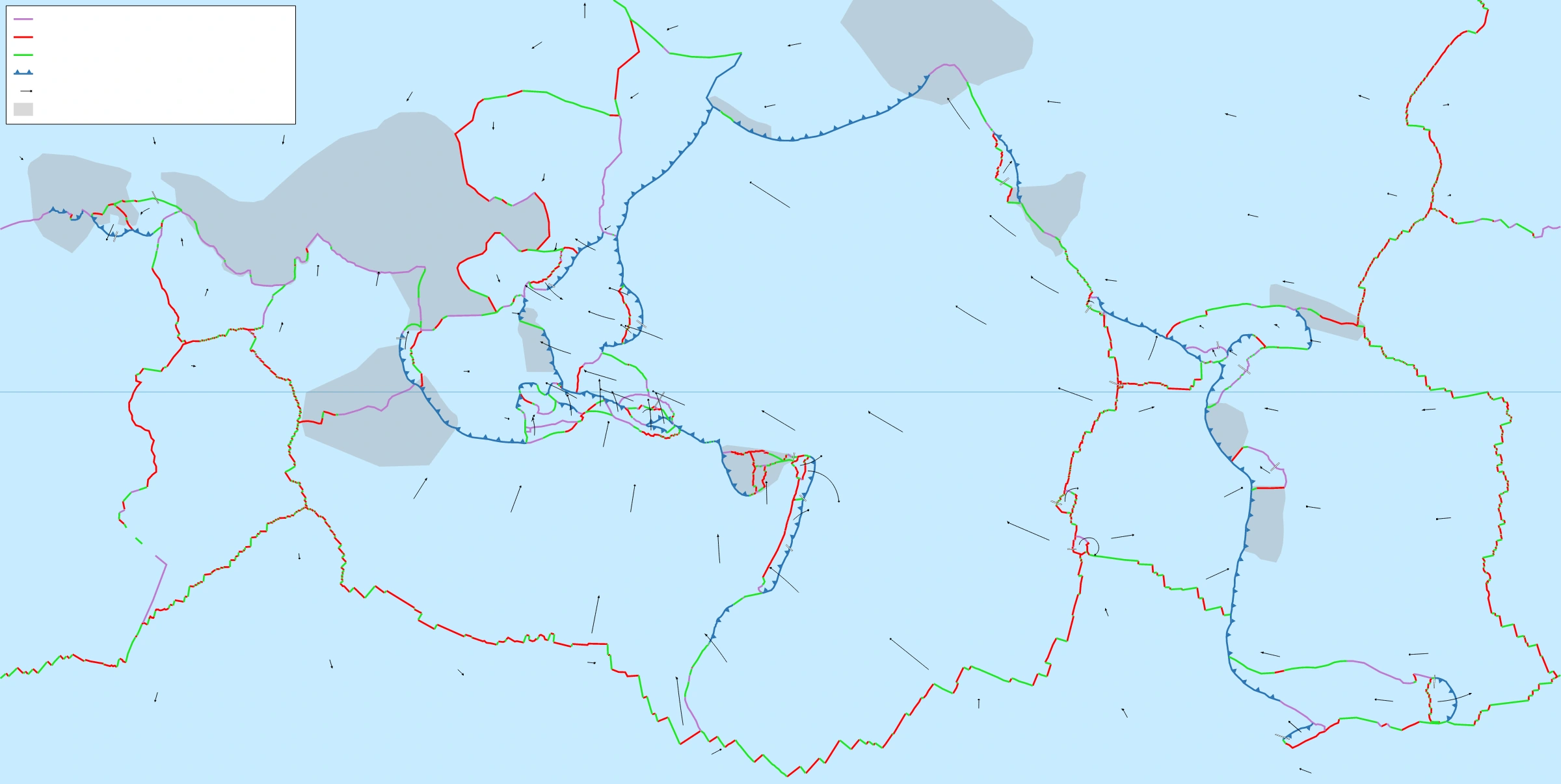
Map study
World tectonic plates: locate the Indian and Eurasian plates and distinguish convergent, divergent and transform boundaries through the legend.
- Read the source legend, scale and reference period before comparing regions.
- Connect spatial patterns to the processes discussed in this topic; this map is a study reference, not live operational data.
Credit: Eric Gaba (Sting) · CC BY-SA 2.5 · sourceConverted to WebP on an opaque white background; proportionally resized without cropping. Original cartography and legend retained.
1. Origin of magma and controls on eruptions
A volcano is both a vent connecting Earth’s interior with the surface and, commonly, the landform built by erupted material. A volcanic system may contain zones of magma storage, conduits, fissures and several vents rather than one simple pipe. Magma contains melt, crystals and dissolved gases, especially water vapour, carbon dioxide and sulphur dioxide. The mantle is predominantly solid; melting occurs locally when pressure, temperature or composition changes.
Three mechanisms generate magma. Decompression melting occurs when hot mantle rises and pressure falls, as beneath mid-ocean ridges, continental rifts and many hotspots. Flux melting occurs when water and other volatiles released from a subducting slab lower the melting temperature of the overlying mantle wedge. Heat-transfer melting occurs when hotter magma supplies heat to surrounding crustal rocks. Subduction volcanism therefore should not be explained simply as melting caused by friction between plates.
Eruption style depends strongly on viscosity and gas behaviour. Hot basaltic magma usually has relatively low silica content and low viscosity, allowing gases to escape more readily. Cooler, silica-rich rhyolitic magma is generally more viscous and may trap gas, promoting explosive fragmentation. Crystal content also affects viscosity. These are tendencies, not absolute rules: basaltic eruptions can become highly explosive, especially when magma interacts with water.
- Effusive eruption: lava mainly flows onto the surface.
- Explosive eruption: expanding gases fragment magma and surrounding rock.
- Phreatic eruption: heated groundwater produces a steam-driven explosion, potentially without new magma.
- Phreatomagmatic eruption: direct magma–water interaction contributes to fragmentation.
2. Plate-tectonic distribution and Indian examples
At divergent boundaries, plates separate and mantle rises, producing predominantly basaltic volcanism. Much of this activity occurs underwater along the global mid-ocean ridge system. Iceland exposes part of the Mid-Atlantic Ridge above sea level and also overlies a hotspot. Continental rifting, illustrated by the East African Rift, can similarly facilitate magma ascent.
At convergent boundaries involving subduction, fluids released from the descending plate trigger melting in the mantle wedge. Volcanoes develop on the overriding plate, forming island arcs such as Japan and the Aleutians, or continental arcs such as the Andes. These belts commonly contain explosive composite volcanoes. Ocean trenches and volcanic arcs are associated features, but volcanoes do not normally sit directly above the trench. Transform boundaries generally lack extensive volcanism because horizontal plate motion does not itself favour melting.
Hotspot volcanism occurs away from some plate boundaries. Hawaii illustrates a volcanic chain formed as the Pacific Plate moves over a relatively persistent mantle melting source. Volcano ages generally increase away from the currently active southeastern end. Yellowstone is a continental hotspot example with a contrasting, strongly crust-influenced magmatic system.
In India, Barren Island belongs to the Andaman volcanic arc, associated with subduction of the Indian plate beneath the Burma microplate. It resumed recorded activity in 1991 after a long quiet interval. Nearby Narcondam is another volcanic island, but should not be confused with India’s confirmed active volcano. The Deccan Traps are an ancient flood-basalt province, formed mainly around 66 million years ago through extensive fissure-fed eruptions and associated with the Réunion hotspot.
- Map priority: Pacific Ring of Fire, Mid-Atlantic Ridge, East African Rift, Hawaii, Yellowstone, Andaman Sea and Deccan Plateau.
- Trap derives from a term meaning stairs, referring to the step-like relief produced by successive lava flows.
Simplified development of a gas-driven explosive eruption
- 1. Partial melting generates magma
- 2. Magma rises and may accumulate in reservoirs
- 3. Falling pressure allows dissolved gases to form bubbles
- 4. Restricted gas escape increases pressure
- 5. Fragmentation produces ash, eruption columns and potentially pyroclastic currents
3. Volcanic materials and landforms
Shield volcanoes are broad, gently sloping edifices built mainly by fluid lava; Mauna Loa is a standard example. Composite volcanoes, or stratovolcanoes, develop from repeated lava flows and fragmental deposits and commonly have steep profiles; Mount Fuji is an example. Cinder cones consist mainly of loose scoria and other fragments accumulated around a vent. Lava domes form when viscous lava piles up near its point of emergence.
A crater is a relatively small depression around a vent, produced by explosive excavation or collapse. A caldera is a larger depression formed mainly when the ground collapses after substantial withdrawal of magma from a shallow reservoir. Calderas are therefore not simply oversized explosion craters. Fissure eruptions can construct extensive lava plateaus without building a prominent central cone. Lava erupted underwater commonly forms pillow structures because its exterior chills rapidly.
Tephra is the collective term for airborne volcanic fragments. Ash is smaller than 2 millimetres, lapilli range from 2 to 64 millimetres, and bombs or blocks exceed 64 millimetres. Bombs are ejected while molten or partly molten; blocks are already solid. Intrusive landforms develop when magma cools underground: dykes cut across rock structures, sills follow them, laccoliths dome overlying strata, and batholiths are large intrusive bodies exposed by erosion.
- Pahoehoe: relatively smooth or ropy basaltic lava surface.
- Aa: rough, jagged basaltic lava surface.
- A volcanic neck is resistant material within a former conduit exposed by erosion.
| Setting | Main melting control | Examples | Typical expression |
|---|---|---|---|
| Divergent boundary | Decompression | Mid-Atlantic Ridge | Basaltic fissures and submarine lava |
| Subduction zone | Volatile addition | Andes; Andaman arc | Volcanic arcs and composite cones |
| Oceanic hotspot | Upwelling and decompression | Hawaii | Basaltic shield volcanoes |
| Continental hotspot | Mantle melting and crustal interaction | Yellowstone | Calderas and varied magma compositions |
| Flood-basalt province | Large-volume mantle melting | Deccan Traps | Extensive stacked lava flows |
4. Hazards, environmental effects and benefits
Pyroclastic density currents are fast-moving mixtures of hot gases and volcanic particles that can devastate areas around a volcano. Lahars are flows of water and volcanic sediment, triggered by rainfall, melting snow or ice, or lake release; they can travel far along valleys even after an eruption ends. Ash damages crops, contaminates water, overloads roofs and threatens aircraft engines. Carbon dioxide may accumulate in low-lying areas and cause asphyxiation.
Large explosive eruptions can inject sulphur dioxide into the stratosphere, where sulphate aerosols reflect incoming sunlight and produce temporary global cooling. This effect is distinct from short-lived local cooling by ash. Volcanic carbon dioxide contributes to the long-term carbon cycle, but present-day human emissions greatly exceed volcanic emissions. Eruptions, flank collapses and underwater mass movements may also generate tsunamis.
Volcanism creates new land and supplies parent material for potentially fertile soils, although soil development requires weathering and time. Volcanic regions offer geothermal energy, mineral resources and tourism opportunities. These benefits often encourage settlement in hazardous locations.
- Hazard severity depends on eruption characteristics; disaster losses also depend on exposure, vulnerability and preparedness.
- Lava flows are often slower than pyroclastic currents, but can still destroy infrastructure and isolate communities.
5. Monitoring and examination essentials
Monitoring combines earthquake records, ground deformation measured by GNSS and satellite radar, gas emissions, thermal observations and visual surveillance. Scientists interpret changes together; no single signal guarantees an eruption. Hazard maps, exclusion zones, evacuation routes and public communication translate monitoring into risk reduction. Valley-specific lahar warnings and aviation ash advisories address hazards extending beyond the immediate vent.
Active, dormant and extinct describe broad assessments of volcanic activity, but there is no universally applicable time threshold. A long quiet interval does not prove extinction. The Volcanic Explosivity Index uses erupted fragmental volume, eruption-column height and descriptive evidence; most successive levels represent roughly tenfold increases in ejecta volume. It does not directly measure lava-flow damage, mortality or every dimension of eruption intensity.
- Do not equate all volcanoes with plate boundaries or all eruptions with explosions.
- Distinguish present volcanic activity from ancient volcanic terrain.
- For map questions, connect each volcano with its plate setting, neighbouring sea and country.
Real-world case studies
Mount Pinatubo, Philippines, 1991
The June 1991 eruption injected substantial sulphur dioxide into the stratosphere, contributing to temporary global cooling of about 0.5°C. Monitoring and evacuation reduced casualties, while rainfall remobilised ash into destructive lahars for years.
Nevado del Ruiz, Colombia, 1985
Hot eruptive material melted summit snow and ice, generating lahars that devastated Armero and killed about 23,000 people. The disaster demonstrates how a comparatively limited eruption can cause catastrophic losses far downstream.
Previous year questions
No source-linked PYQ is available here yet. Use the practice questions below.
Practice questions
Practice MCQ 1
Consider the statements: 1. Rising mantle can melt because pressure decreases. 2. Slab-derived water can lower the melting temperature of mantle rocks. 3. Transform motion generally produces extensive volcanic arcs. Which are correct?
- A. 1 and 2 only
- B. 2 and 3 only
- C. 1 and 3 only
- D. 1, 2 and 3
Practice MCQ 2
Which pair is correctly matched?
- A. Dyke — intrusion parallel to bedding by definition
- B. Lahar — water-rich flow of volcanic sediment
- C. Caldera — accumulation of loose cinders
- D. Pillow lava — wind-deposited volcanic ash
Practice MCQ 3
Which statement about Indian volcanism is correct?
- A. Barren Island lies in the Arabian Sea.
- B. The Deccan Traps formed mainly through modern eruptions.
- C. Barren Island is associated with the Andaman subduction system.
- D. Narcondam forms part of the Hawaiian hotspot chain.
Mains practice · Explain how plate-tectonic setting and magma properties influence volcanic landforms and hazards. Illustrate with examples. (250 words)
- Explain decompression melting, flux melting and hotspot volcanism.
- Link viscosity and gas retention with effusive and explosive activity.
- Compare shields, composite cones, calderas and flood basalts.
- Use Hawaii, Andes, Barren Island and Deccan examples.
- Distinguish eruption magnitude from exposure and vulnerability; conclude with monitoring and preparedness.
Further reading
- NCERT, Fundamentals of Physical Geography, Class XI: Interior of the Earth; Distribution of Oceans and Continents.
- US Geological Survey, Volcano Hazards Program: volcanoes.usgs.gov.
- Smithsonian Institution, Global Volcanism Program: volcano.si.edu.
- Geological Survey of India: publications on Barren Island and the Deccan volcanic province.
Preparing for UPSC Civil Services? Get classroom teaching, answer-writing evaluation and mentorship at Pragnya IAS Academy, Ashok Nagar — see why aspirants choose us for IAS coaching in Hyderabad.