
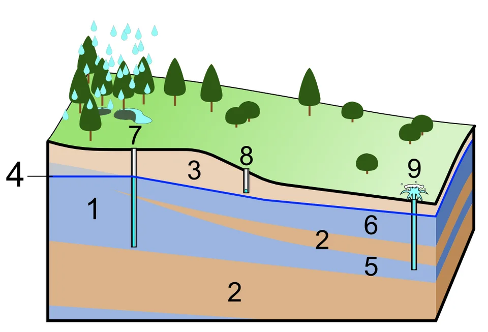
Conceptual groundwater diagram identifying aquifers, an aquitard, the water table and well types.
Credit: Shigeru23 · CC BY-SA 3.0 · sourceResized and converted to WebP; uncropped.
1. Aquifers and the occurrence of groundwater
An aquifer is a geological formation, group of formations or part of a formation that is sufficiently permeable to yield useful quantities of water to wells or springs. Groundwater originates mainly from precipitation and surface water that infiltrate the soil and percolate downward. Above the water table lies the unsaturated or vadose zone, where pore spaces contain both air and water. In the saturated zone, interconnected openings are filled with water. The capillary fringe immediately above the water table is an important qualification: water can rise into it by capillary action.
Porosity is the proportion of a material’s total volume occupied by voids. Primary porosity develops during rock formation, as between sand grains; secondary porosity develops later through fracturing, weathering or dissolution. Permeability describes the ability of interconnected openings to transmit fluid. Clay may have high porosity but very low permeability because its pores are extremely small. Sand and gravel commonly combine useful storage with high permeability.
Specific yield is the fraction of saturated material’s volume that drains under gravity. It is therefore more relevant to recoverable water in an unconfined aquifer than total porosity alone. Transmissivity measures the water-transmitting capacity of the entire saturated thickness of an aquifer. These distinctions explain why two wells receiving similar rainfall can have very different yields.
- Aquitard: a relatively low-permeability layer that restricts groundwater movement but may transmit water slowly.
- Aquiclude: a formation that may contain water but transmits negligible quantities under ordinary conditions.
- Aquifuge: an effectively non-porous, impermeable formation that neither stores nor transmits appreciable groundwater.
2. Types of aquifers and groundwater movement
An unconfined aquifer has a water table as its upper boundary and lacks a confining layer above it. Recharge reaches it through the overlying unsaturated zone, and its water table commonly rises after the monsoon and falls during the dry season. A confined aquifer is overlain by a low-permeability layer and contains water under pressure. Recharge can occur where the aquifer outcrops or through leakage across confining beds. Confinement does not mean complete isolation or immunity from pollution.
In a well tapping a confined aquifer, water rises to the potentiometric level. Such a well is artesian, but it flows at the surface only if that level is higher than the ground. A perched aquifer is a local saturated body above the regional water table, supported by a discontinuous low-permeability layer. It may provide seasonal water but often has limited storage.
Groundwater flows from higher to lower hydraulic head, which combines elevation and pressure effects. Darcy’s law relates flow through porous media to hydraulic conductivity, hydraulic gradient and cross-sectional area. Pumping lowers head around a well, creating a cone of depression; overlapping cones can cause interference between wells. Aquifer boundaries need not coincide with surface drainage divides. Gaining rivers receive groundwater, while losing reaches recharge it, and the direction of exchange may change seasonally.
- Prelims distinction: the water table is a physical saturation boundary; the potentiometric surface represents hydraulic head.
- High rainfall does not automatically imply high groundwater availability: infiltration, slope, geology, vegetation and extraction also matter.
Aquifer-based groundwater planning
- 1. Map geological layers, fractures, aquifer boundaries and recharge areas.
- 2. Monitor seasonal groundwater levels, abstraction and water quality.
- 3. Estimate recharge, extractable resources and the local water budget.
- 4. Identify depletion hotspots, contamination sources and dependent ecosystems.
- 5. Combine demand management with scientifically sited recharge and source protection.
- 6. Review monitoring results and revise community extraction rules.
3. Major aquifer systems of India
The Indo-Gangetic-Brahmaputra plains contain extensive unconsolidated alluvial aquifers. Sand and gravel beds generally transmit water efficiently, while intervening clay layers create multi-layered unconfined, semi-confined and confined conditions. These aquifers support intensive irrigation and large settlements. However, abundant storage does not guarantee sustainability: parts of Punjab, Haryana, Rajasthan and western Uttar Pradesh experience severe extraction pressure. Arsenic contamination affects groundwater in parts of the Ganga-Brahmaputra alluvial region.
Across much of peninsular India, granite, gneiss and other crystalline rocks have little primary porosity. Groundwater occurs mainly in weathered zones and connected fractures. Storage is often limited and well yields vary sharply over short distances. Telangana, including the Hyderabad region, illustrates this hard-rock setting. A deeper borewell is not necessarily more productive because it may fail to intersect water-bearing fractures.
Deccan Trap basalt stores groundwater in weathered horizons, joints, vesicular zones and contacts between lava flows; massive flow interiors are often less permeable. Sandstone aquifers depend on intergranular pores and fractures, while limestone can develop high-transmissivity karst conduits through dissolution. Himalayan groundwater commonly emerges as springs from fractured rocks and weathered deposits. Coastal aquifers face saline intrusion where pumping disrupts the freshwater-seawater balance.
- Arid western India contains both alluvial and sedimentary aquifers, but low recharge and salinity frequently constrain usable supplies.
- Aquifer productivity and water quality must be assessed separately: a high-yielding well may still supply unsafe water.
| Setting | Main storage and flow spaces | Indian example | Key concern |
|---|---|---|---|
| Alluvial | Pores between sand and gravel grains | Indo-Gangetic plains | Over-extraction; arsenic in some areas |
| Crystalline hard rock | Weathered zones and connected fractures | Telangana and Karnataka | Limited storage and highly variable well yields |
| Basalt | Joints, weathered and vesicular zones, flow contacts | Deccan Plateau | Discontinuous productive horizons |
| Karst limestone | Dissolution-enlarged fractures and conduits | Parts of Meghalaya | Rapid contaminant transport through conduits |
| Coastal deposits | Pores in sands and other permeable sediments | Coastal Tamil Nadu and Gujarat | Saline intrusion under excessive pumping |
4. Recharge, depletion and water-quality risks
Natural recharge occurs through rainfall infiltration, riverbeds, floodplains and other permeable surfaces. Canal seepage and irrigation return flows also contribute, although return flows may carry salts and agricultural chemicals. Urban paving can reduce diffuse recharge while leaking pipes create localised recharge. Groundwater discharge occurs through springs, river baseflow, evapotranspiration from shallow water tables and pumping.
Persistent extraction beyond replenishment can lower water levels, increase pumping costs, dry shallow wells and reduce dry-season river flow. In compressible sedimentary basins, declining pressure can cause aquifer-system compaction and land subsidence. Groundwater assessment therefore involves more than counting wells: recharge, extraction, natural discharge and ecological needs must be considered. Large groundwater storage may conceal depletion for years, particularly where replenishment is slow.
Water-quality threats can be geogenic or anthropogenic. Arsenic mobilisation in some alluvial settings and fluoride enrichment in some hard-rock regions reflect geological and geochemical conditions, although pumping and recharge changes can influence them. Fertilisers, sewage and waste disposal can introduce nitrate, pathogens and industrial pollutants. Polluted groundwater is difficult and expensive to restore. Managed aquifer recharge requires suitable geology, safe source water, sediment control and maintenance; untreated wastewater should not be routed directly into recharge structures.
- Recharge pits, check dams and percolation tanks work only where site conditions permit infiltration and useful subsurface storage.
- Coastal over-pumping may cause lateral saline intrusion or upward movement of deeper saline water, known as upconing.
5. Assessment and sustainable aquifer management
The Central Ground Water Board, under the Ministry of Jal Shakti, undertakes groundwater exploration, monitoring and assessment. The National Aquifer Mapping and Management Programme, commonly called NAQUIM, identifies aquifer geometry, characteristics, water levels and quality to support management plans. Dynamic groundwater assessments classify assessment units using the stage of groundwater extraction: annual extraction divided by annual extractable groundwater resource, expressed as a percentage. This is not the percentage of total underground storage already removed.
Management must combine supply-side measures with demand reduction. Aquifer-based water budgets, crop choices suited to local water availability, efficient irrigation and coordinated pumping can reduce stress. Irrigation efficiency alone may not save water at basin scale if farmers expand irrigated area or shift to more water-demanding crops. Recharge zones, wetlands and floodplains require protection, while drinking-water sources need sanitary safeguards and regular testing.
Atal Bhujal Yojana was designed as a community-led groundwater-management programme in selected water-stressed areas of seven states: Gujarat, Haryana, Karnataka, Madhya Pradesh, Maharashtra, Rajasthan and Uttar Pradesh. The Central Ground Water Authority regulates specified groundwater withdrawals under powers derived from the Environment (Protection) Act, 1986, alongside state-level arrangements. Because neighbouring wells often tap a shared aquifer, effective governance requires collective rules rather than treating every borewell as an independent resource.
- Standard extraction-stage categories: safe at 70% or below; semi-critical above 70% up to 90%; critical above 90% up to 100%; over-exploited above 100%.
- For planning, distinguish annual replenishable resources from older groundwater reserves and distinguish resource availability from drinking-water suitability.
Aquifer confinement, groundwater pressure and wells
The supplied metadata identifies a conceptual diagram of aquifers, an aquitard, the unsaturated zone and different wells. These categories distinguish groundwater storage from groundwater movement. An aquifer must both hold water and transmit it sufficiently to supply wells or springs; porosity alone does not establish its usefulness. An aquitard restricts flow because of its relatively low permeability, but need not be completely impermeable. The water table forms the upper boundary of an unconfined aquifer, whereas a confined aquifer lies beneath a restricting layer and contains water under pressure.
In India, extensive alluvial deposits can support aquifers through interconnected pore spaces, while groundwater in hard-rock terrain commonly occupies weathered zones and fractures. Neither setting guarantees dependable yield or safe water quality. A well tapping a confined aquifer may show water rising above the aquifer’s upper boundary; it flows naturally at the surface only when the pressure level exceeds ground elevation. This generic schematic is not evidence of aquifer depth, recharge rates or groundwater availability at any particular Indian location.
- Distinguish the water table from the potentiometric surface: the latter represents the level to which water rises in wells tapping a confined aquifer.
- Do not equate artesian with automatically free-flowing, or deep groundwater with necessarily clean, renewable or abundant groundwater.
- For sustainable extraction, assess recharge, pumping, water quality and effects on connected rivers and ecosystems; stored groundwater is not an unrestricted annual supply.
Real-world case studies
Community groundwater budgeting in Andhra Pradesh
The Andhra Pradesh Farmer Managed Groundwater Systems project supported farmers in hard-rock areas through groundwater monitoring, rainfall measurement and crop-water budgeting. Farmers used shared information to discuss cropping decisions against estimated water availability. Its central lesson is that hydrogeological literacy and collective demand management can complement recharge works; constructing additional borewells does not create additional groundwater.
Arsenic in West Bengal’s alluvial aquifers
Parts of West Bengal’s Ganga delta contain arsenic-contaminated groundwater, often associated with reducing conditions that release arsenic from iron-bearing sediments. Contamination varies by location and aquifer depth, so visual clarity does not indicate safety. Responses include systematic testing, verified safe sources, treatment and appropriately designed piped supplies. Deeper groundwater should not be assumed safe without testing and sound well construction.
Previous year questions
No source-linked PYQ is available here yet. Use the practice questions below.
Practice questions
Practice MCQ 1
With reference to groundwater, consider the following statements: 1. A material with high porosity must also have high permeability. 2. Specific yield measures the proportion of water that drains from saturated material under gravity. 3. Groundwater flow is governed by differences in hydraulic head. Which statements are correct?
- A. 1 and 2 only
- B. 2 and 3 only
- C. 1 and 3 only
- D. 1, 2 and 3
Practice MCQ 2
A well tapping a confined aquifer will flow naturally at the ground surface when:
- A. The aquifer contains only freshwater
- B. The aquifer lies below an impermeable layer, irrespective of pressure
- C. The potentiometric surface is above the ground at the well
- D. The regional water table lies below the bottom of the well
Practice MCQ 3
Consider the following aquifer-setting pairs: 1. Peninsular granite and gneiss: groundwater mainly in weathered and fractured zones. 2. Deccan basalt: groundwater uniformly distributed through all massive lava interiors. 3. Coastal aquifers: excessive pumping can induce saline intrusion. Which pairs are correctly matched?
- A. 1 only
- B. 2 and 3 only
- C. 1 and 3 only
- D. 1, 2 and 3
Mains practice · Groundwater stress in India cannot be resolved through recharge structures alone. Discuss with reference to aquifer diversity and demand management. Answer in 250 words.
- Explain differences between extensive alluvial storage and discontinuous hard-rock aquifers.
- Relate depletion to extraction, cropping patterns, irrigation incentives and urban demand.
- Discuss geological constraints, contamination risks and maintenance requirements of recharge structures.
- Use NAQUIM, community water budgeting and Atal Bhujal Yojana as institutional examples.
- Recommend crop-water alignment, monitored abstraction, quality protection and protection of groundwater-dependent ecosystems.
- Conclude with locally tailored, aquifer-based collective management.
Further reading
- NCERT, India: Physical Environment, Class XI: Drainage System.
- NCERT, India: People and Economy, Class XII: Water Resources.
- Central Ground Water Board: National Aquifer Mapping and Management Programme reports, cgwb.gov.in.
- Central Ground Water Board: National Compilation on Dynamic Ground Water Resources of India, latest edition.
- Ministry of Jal Shakti: Atal Bhujal Yojana guidelines and official programme resources.
- Central Ground Water Authority: Guidelines for regulation and control of groundwater extraction.
- https://commons.wikimedia.org/wiki/File:Groundwater_(aquifer,_aquitard,_3_type_wells).PNG
Preparing for UPSC Civil Services? Get classroom teaching, answer-writing evaluation and mentorship at Pragnya IAS Academy, Ashok Nagar — see why aspirants choose us for IAS coaching in Hyderabad.