
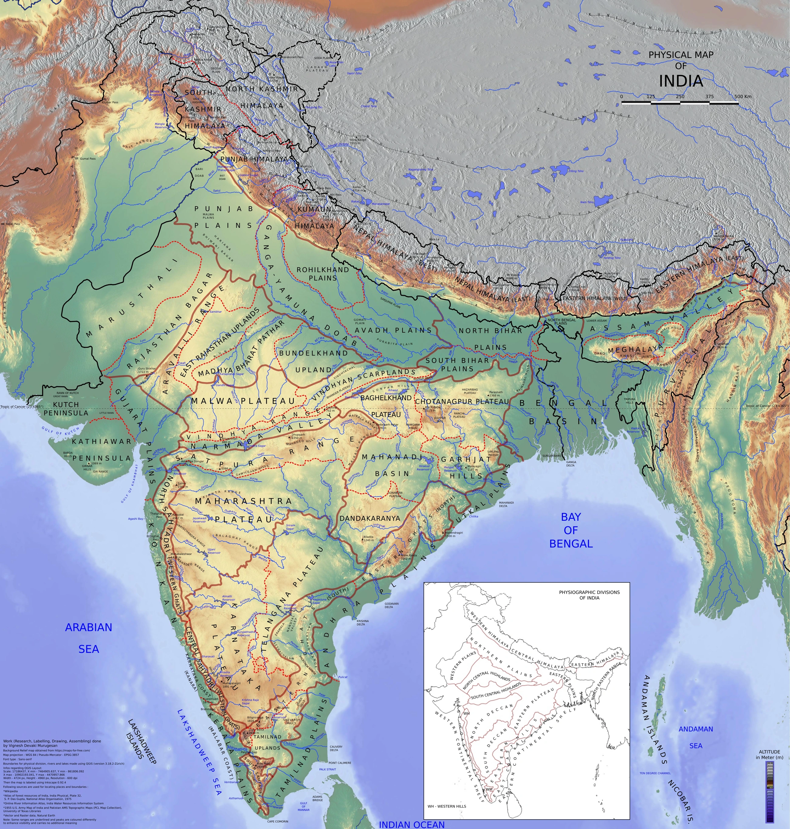
Map study
Physical divisions of India: locate mountains, plains, plateau, desert, coast and islands. Use regional relief to interpret landform processes; this is not a local geomorphological survey.
- Read the legend and reference date before interpreting regional patterns.
- Relate the map to the article’s topic; verify current administrative boundaries or data separately.
Credit: Vigneshdm1990 · CC BY-SA 4.0 · sourceConverted to WebP on an opaque white background; proportionally resized without cropping. Original cartography and legend retained.
1. Location, origin and geomorphic setting
The coastal plains fringe the Indian peninsula between its uplands and the sea. The western belt extends through Gujarat, Maharashtra, Goa, Karnataka and Kerala towards Kanniyakumari; the eastern belt extends through West Bengal, Odisha, Andhra Pradesh and Tamil Nadu. These plains are not uniform strips. Rocky headlands, tidal creeks, river mouths, sand barriers, mudflats and marshes interrupt them, while Gujarat’s coastal lowlands differ considerably from the narrow belt alongside the Western Ghats.
Their development reflects interactions among tectonic movements, relative sea-level change, sediment supply and waves, tides and currents. Rivers deposit alluvium as their gradients decrease near the coast. Waves and longshore currents redistribute this material into beaches, spits and barrier features. Enclosed or partly enclosed water bodies may develop behind such barriers. Sea-level changes can drown river valleys or expose former seabeds.
NCERT describes the western coastal plain as an example of a submerged coastal plain and the eastern coastal plain as an emergent coast. This is a useful broad classification, not a claim that every stretch has the same geological history. Local uplift, subsidence, erosion and deposition produce substantial variation. Submergence helps explain indented western shorelines and sheltered harbour sites, while extensive river deposition explains much of the eastern coast’s deltaic character.
- Delta: a depositional landform at a river mouth, commonly containing distributary channels.
- Estuary: a coastal water body connected to the sea where river water and seawater mix under tidal influence.
- Lagoon: a shallow coastal water body partly separated from the sea by a sand barrier, spit or similar feature.
2. Western coastal plain: divisions and landforms
The western coastal plain is generally narrow because the Western Ghats rise close to the Arabian Sea. Many west-flowing peninsular rivers are short, descend steeply and drain relatively small catchments. Consequently, this coast lacks a continuous series of large, projecting deltas comparable to those on the east. However, the wider Gujarat plains and the lowlands around major river mouths caution against treating the entire west coast as uniformly narrow.
In the commonly used NCERT school division, the Konkan extends approximately from Mumbai to Goa, the Kannad plain occupies the central stretch, and the Malabar coast forms the southern stretch. More detailed regional schemes separately identify Gujarat and use terms such as Kanara for coastal Karnataka. Boundaries of historical coastal names vary between sources; in examination questions, follow the definition used in the relevant standard text.
The Konkan has creeks, headlands and intervening lowlands. Coastal Karnataka includes the mouths of rivers such as the Kali, Sharavathi and Netravati. Kerala’s Malabar coast is especially associated with lagoons and interconnected backwaters, including Vembanad and Ashtamudi. These support fisheries, inland navigation, tourism and farming. The Narmada and Tapi, farther north, reach the Gulf of Khambhat, where strong tidal action helps shape their estuarine environments.
- Mumbai and Mormugao illustrate sheltered harbour locations on the western coast.
- Kochi is associated with an inlet connecting the sea and the Vembanad backwater system.
- Kayal is a regional term associated with Kerala’s backwaters; not every western coastal water body is a lagoon.
Development of a coastal lagoon
- 1. Rivers and eroding shores supply sediment to coastal waters
- 2. Waves and longshore currents transport sediment along the shoreline
- 3. A spit or barrier develops across part of a coastal embayment
- 4. A shallow water body becomes partly separated from the open sea
- 5. Freshwater inflow and tidal exchange through inlets determine salinity and ecology
3. Eastern coastal plain: deltas and lagoons
The eastern coastal plain is generally wider and more continuous than its western counterpart. The discontinuous Eastern Ghats stand inland and are crossed by major rivers. Long east-flowing rivers drain extensive parts of the plateau and deliver sediment to the Bay of Bengal. Their lower courses build floodplains, distributary networks and deltas, although sediment deposition is continually modified by waves, tides and storms.
Standard broad divisions identify the Northern Circars in the northern part and the Coromandel Coast in the southern part. Northern Circars is historically associated mainly with the Andhra coastal tract; detailed geographical accounts also discuss the Odisha or Utkal coast separately. Coromandel is associated with Tamil Nadu and adjoining southeastern coastal areas. The Mahanadi delta lies in Odisha, the Godavari and Krishna deltas mainly in Andhra Pradesh, and the Kaveri delta in Tamil Nadu.
Important coastal water bodies require careful identification. Chilika, south of the Mahanadi delta in Odisha, is a brackish-water lagoon connected to the sea through inlets. Pulicat is a lagoon spanning Andhra Pradesh and Tamil Nadu, separated from the Bay of Bengal by the Sriharikota barrier island. Kolleru, between the Krishna and Godavari deltas, is a freshwater lake rather than a typical marine lagoon. These distinctions frequently lend themselves to location-based and statement-based questions.
- Sriharikota hosts the Satish Dhawan Space Centre and separates Pulicat lagoon from the sea.
- Bhitarkanika mangroves occupy the Brahmani–Baitarani deltaic region of Odisha.
- The Sundarbans occupy the Ganga–Brahmaputra–Meghna delta; their Indian part lies in West Bengal and is distinct from the deltas of peninsular rivers.
| Feature | Western coastal plain | Eastern coastal plain |
|---|---|---|
| Relief and width | Generally narrow; Western Ghats close to shore | Generally wider; Eastern Ghats discontinuous and inland |
| Textbook geomorphic classification | Broadly a submerged coast | Broadly an emergent coast |
| River-mouth pattern | Many estuarine mouths; no comparable chain of large projecting deltas | Extensive Mahanadi, Godavari, Krishna and Kaveri deltas |
| Regional names | Gujarat, Konkan, Kanara/Kannad and Malabar | Utkal/Odisha, Northern Circars and Coromandel |
| Representative water bodies | Vembanad and Ashtamudi backwaters | Chilika and Pulicat lagoons |
4. Climate, resources and settlement
Coastal location moderates temperature, but rainfall differs markedly. The southwest monsoon’s Arabian Sea branch produces heavy rainfall along much of the western coast as moist air rises against the Western Ghats. Coastal Tamil Nadu lies relatively sheltered from this airflow and receives an important rainfall contribution during the October–December northeast monsoon season. Bay of Bengal depressions and cyclones also influence southeastern coastal rainfall.
Alluvial soils, distributary channels and irrigation have made the eastern deltas major rice-growing regions. Coconut, fisheries and plantation-linked trade are prominent along parts of the western coast. Estuaries, lagoons and mangroves provide breeding and nursery habitats for aquatic species. Salt production, aquaculture, ports, petrochemical industries and tourism create additional economic value, but can compete with farming, fishing access and wetland conservation.
Coastal plains concentrate cities and infrastructure because they offer relatively accessible land, maritime connections and river corridors. Harbour suitability cannot, however, be inferred from coastal width alone. Water depth, shelter, sedimentation, waves and access to the hinterland are critical. Chennai is conventionally described as an artificial harbour, while Visakhapatnam benefits from natural shelter. Both eastern and western ports may require dredging and engineered protection.
- Mangroves typically occur in sheltered intertidal settings, not along every sandy beach.
- Heavy-mineral beach sands containing ilmenite, rutile and monazite occur along selected stretches, including parts of Kerala, Tamil Nadu and Odisha.
- Low elevation makes deltaic agriculture productive but exposes settlements and infrastructure to waterlogging, flooding and salinity.
5. Hazards, coastal management and examination approach
Coastal hazards include shoreline erosion, cyclones, storm surges, river floods, saline intrusion and tsunamis. The Bay of Bengal coast has historically experienced greater cyclone landfall and storm-surge exposure than the Arabian Sea coast, though western India is not cyclone-free. Shallow offshore waters, coastal configuration, tide and cyclone characteristics influence surge severity. The December 2004 Indian Ocean tsunami demonstrated the exposure of Tamil Nadu and other coastal areas to distant earthquake-generated waves.
Dams, sand extraction and changes in river channels can reduce sediment reaching deltas. Groundwater withdrawal and subsidence may intensify relative sea-level rise locally. Seawalls and groynes can protect specific assets but sometimes transfer erosion downdrift by interrupting sediment movement. Management therefore needs sediment-cell assessment, wetland protection, appropriate building setbacks, warning systems and evacuation planning rather than a uniform hard-engineering solution.
India’s Coastal Regulation Zone framework operates under the Environment (Protection) Act, 1986. The CRZ Notification, 2019 provides differentiated regulation of ecologically sensitive, developed, rural and water areas; applicable provisions and approved coastal zone management plans must be checked for a particular location. For Prelims, combine this governance context with map work: mark river mouths, deltas, lagoons, gulfs and ports, and distinguish broad textbook generalisations from absolute statements.
- Reject absolute claims such as all western rivers form estuaries or all eastern ports are artificial.
- Distinguish erosion from submergence: the first involves sediment removal, while the second concerns relative inundation of land.
- For coastline-length questions, check the reference year and measurement method; revised mapping can change the reported length without an equivalent physical expansion of the coast.
Real-world case studies
Chilika: restoring lagoon–sea exchange
Chilika was placed on the Ramsar Montreux Record in 1993 amid ecological deterioration associated with restricted sea exchange, siltation and other pressures. A new sea mouth opened in 2000 as part of restoration improved exchange and supported ecological and fishery recovery. It was removed from the Montreux Record in 2002. The case shows why lagoon conservation must address hydrology, not merely protect the water surface.
Kuttanad: agriculture within a coastal wetland landscape
Kerala’s Kuttanad region contains paddy fields below sea level, cultivated using bunds and water-management systems. FAO recognised the Kuttanad Below Sea Level Farming System as a Globally Important Agricultural Heritage System in 2013. Its relationship with Vembanad illustrates both adaptation to coastal lowlands and the need to balance drainage, flood management, salinity control and wetland ecology.
Previous year questions
UPSC Prelims 2011
Two important rivers, one originating in Jharkhand and the other in Odisha, merge at a place close to the Bay of Bengal before entering the sea. This is an important wildlife and biodiversity site and a protected area. Which site is referred to?
- A. Bhitarkanika
- B. Chandipur-on-sea
- C. Gopalpur-on-sea
- D. Simlipal
Practice questions
Practice MCQ 1
Consider the following pairs: 1. Chilika — Odisha 2. Pulicat — Andhra Pradesh and Tamil Nadu 3. Kolleru — Kerala. Which pairs are correctly matched?
- A. 1 and 2 only
- B. 2 and 3 only
- C. 1 and 3 only
- D. 1, 2 and 3
Practice MCQ 2
Which of the following best explains the extensive deltaic plains along much of India’s eastern coast?
- A. Every eastern coastal river originates in the Himalayas
- B. Large east-flowing peninsular rivers deliver sediment from extensive drainage basins
- C. Tides and waves are entirely absent from the Bay of Bengal
- D. The Eastern Ghats form an unbroken wall along the shoreline
Practice MCQ 3
Consider the following statements: 1. The western coastal plain is uniformly narrow, including all of Gujarat. 2. The Tamil Nadu coast receives important rainfall during the northeast monsoon season. 3. Longshore sediment transport can help form barriers enclosing coastal lagoons. Which statements are correct?
- A. 1 and 2 only
- B. 2 only
- C. 2 and 3 only
- D. 1, 2 and 3
Mains practice · Compare the geomorphological characteristics of India’s eastern and western coastal plains. Explain how these characteristics influence economic activity and vulnerability to hazards. Answer in 250 words.
- Introduce the coastal plains as transitions between the peninsula and adjoining seas.
- Compare width, proximity of the Ghats, river catchments, deltas, estuaries and lagoons.
- Use the Godavari–Krishna deltas, Konkan and Kerala backwaters as examples.
- Link landforms to rice cultivation, fisheries, navigation, ports and tourism.
- Discuss storm surges, delta flooding, erosion, salinity and sediment deficits.
- Conclude with integrated coastal management, ecosystem conservation and location-specific regulation.
Further reading
- NCERT, Contemporary India–I, Class IX: Physical Features of India.
- NCERT, India: Physical Environment, Class XI: Structure and Physiography.
- NCERT, Fundamentals of Physical Geography, Class XI: Landforms and their Evolution.
- Ministry of Environment, Forest and Climate Change: Coastal Regulation Zone Notification, 2019.
- National Centre for Coastal Research: shoreline-change assessments and coastal-management resources.
- Chilika Development Authority: lagoon restoration and ecosystem-monitoring resources.
- FAO: Kuttanad Below Sea Level Farming System, Globally Important Agricultural Heritage Systems.
Preparing for UPSC Civil Services? Get classroom teaching, answer-writing evaluation and mentorship at Pragnya IAS Academy, Ashok Nagar — see why aspirants choose us for IAS coaching in Hyderabad.