
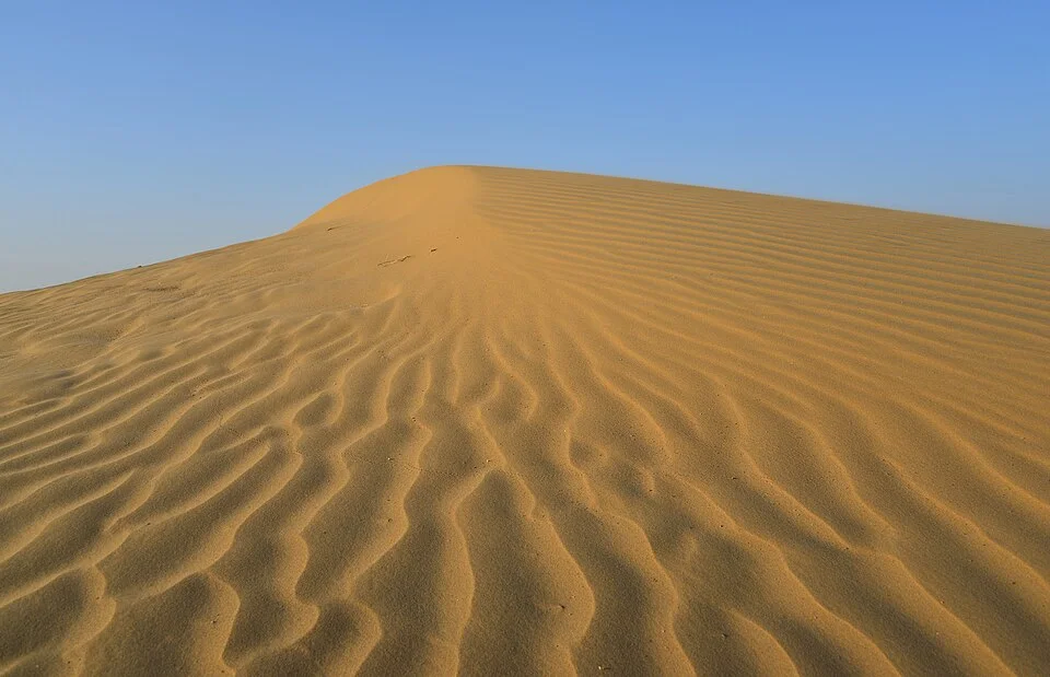
Dunes in the Thar Desert, illustrating an aeolian landform of the Indian Desert.
Credit: Clément Bardot · CC BY-SA 4.0 · sourceResized and converted to WebP; uncropped.
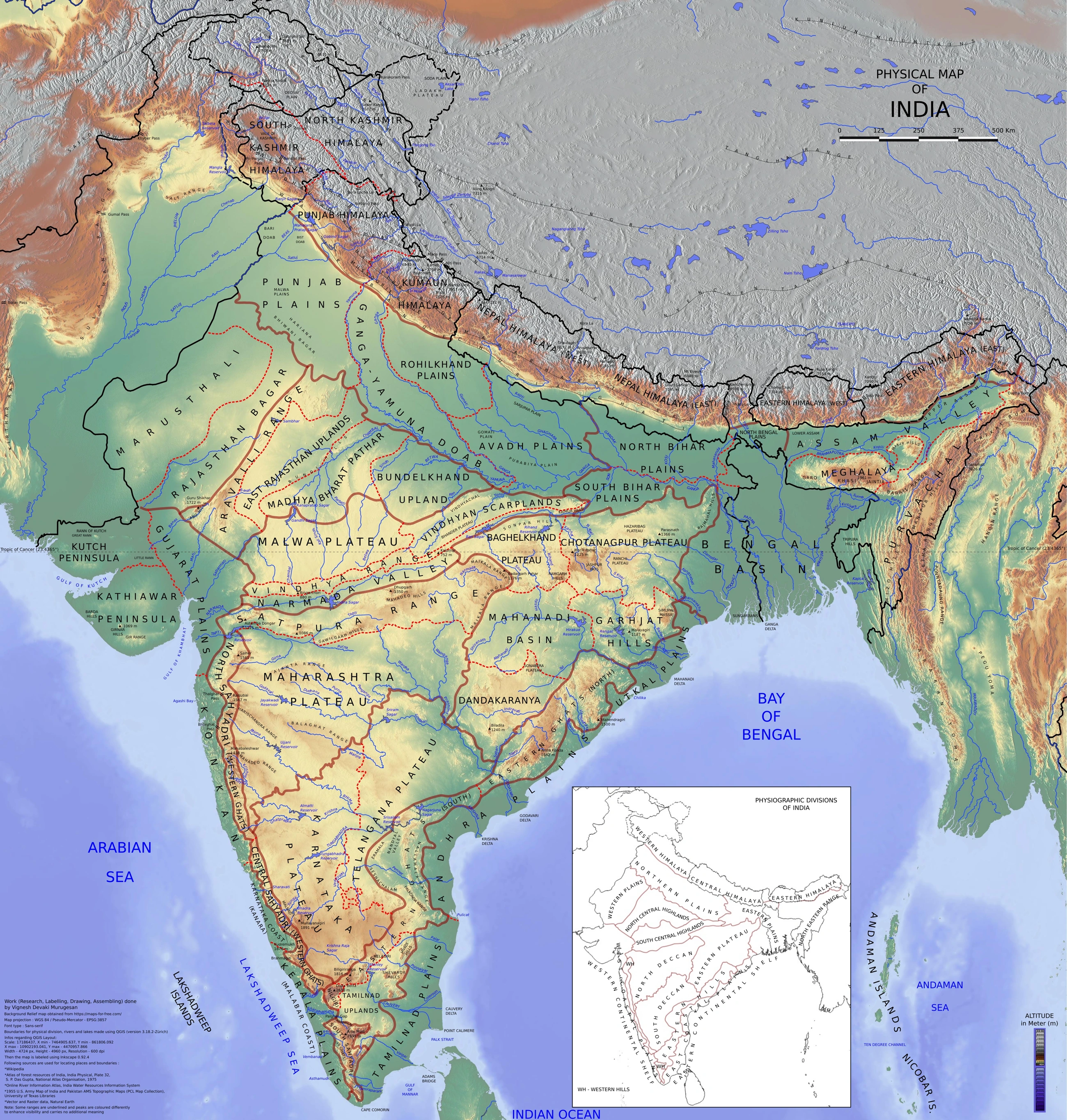
Map study
Physical divisions of India: locate mountains, plains, plateau, desert, coast and islands. Use regional relief to interpret landform processes; this is not a local geomorphological survey.
- Read the legend and reference date before interpreting regional patterns.
- Relate the map to the article’s topic; verify current administrative boundaries or data separately.
Credit: Vigneshdm1990 · CC BY-SA 4.0 · sourceConverted to WebP on an opaque white background; proportionally resized without cropping. Original cartography and legend retained.
1. Location, extent and physiographic character
The Indian Desert is one of the major physiographic divisions recognised in school geography. Its core occupies western Rajasthan, particularly the Jaisalmer, Barmer, Bikaner and adjoining tracts. The wider Thar extends into southeastern Pakistan, especially Sindh and Punjab, while related arid landscapes occur in adjoining Gujarat, Haryana and Punjab. Its eastern transition broadly follows the Aravalli region, its western side approaches the Indus plain, and its southern transition leads towards the Rann of Kachchh.
These boundaries are transitional rather than sharp. The Thar should not be equated with all of Rajasthan, since eastern and southeastern Rajasthan are substantially wetter. Nor should the hot Thar be confused with the cold desert of Ladakh, where high altitude and the Himalayan rain shadow create a different climatic environment.
The surface is an undulating mosaic of dunes, sandy plains, exposed bedrock, gravelly surfaces, pediments and enclosed depressions. Large stretches are not covered by active dunes. Sedimentary rocks around Jaisalmer contain marine fossils, indicating ancient marine conditions. Such geological evidence does not mean that present-day aridity results simply from the retreat of a sea; the modern landscape reflects climatic change, weathering, river processes and wind action over long periods.
- Aravalli: an ancient mountain system forming a broad eastern physiographic reference for the desert.
- Rann of Kachchh: a seasonally inundated saline landscape adjoining the desert region, not simply another sandy dune field.
- Bangar and khadar: alluvial-plain categories, not the principal subdivisions of the Indian Desert.
2. Climate and causes of aridity
The desert has a hot, dry climate with highly variable rainfall concentrated mainly in the southwest monsoon season. The western core is much drier than the eastern margins. NCERT's description of annual rainfall below 150 mm captures the very arid desert environment, but should not be applied uniformly to every locality within the broader Thar. Rainfall generally increases eastward, while long dry spells and recurrent droughts are common.
Aridity results from several interacting controls. Northwestern India lies far inland, monsoon moisture supply is limited and irregular, and the Aravalli Range runs broadly southwest–northeast, approximately parallel to the Arabian Sea branch's movement in this sector. It therefore provides little effective crosswind orographic uplift. The Bay of Bengal branch also loses much of its moisture before reaching the far northwest. Atmospheric circulation and subsidence further influence rainfall.
Summer daytime temperatures can exceed 45°C, whereas winter nights may become quite cold. Clear skies, low humidity and sparse vegetation favour rapid daytime heating and nighttime cooling, producing a large diurnal temperature range. Potential evapotranspiration greatly exceeds precipitation, creating a persistent moisture deficit. Dust storms are frequent during hot, dry periods, and occasional winter rain associated with western disturbances provides limited additional moisture.
- Do not explain the Thar solely as an Aravalli rain-shadow desert: the range's near-parallel orientation and weak uplift are more appropriate explanations.
- Aridity means a long-term climatic moisture deficit; drought is an episode of unusually low water availability.
- Rainfall variability matters as much as low average rainfall for farming and water security.
How poorly managed irrigation can cause secondary salinisation
- 1. Canal seepage and excessive irrigation add water to the ground
- 2. Inadequate drainage allows the water table to rise
- 3. Capillary movement brings dissolved salts towards the surface
- 4. High evaporation leaves salts in the root zone
- 5. Soil productivity declines without drainage and corrective management
3. Wind-shaped landforms, soils and drainage
Wind erodes through deflation, the removal of loose particles, and abrasion, the wearing of surfaces by wind-borne sand. It transports sediment by suspension, saltation and surface creep. Deposition occurs when wind speed declines or vegetation and other obstacles trap sediment. Sparse cover and abundant loose material encourage these processes, although short, intense rainstorms also reshape desert surfaces.
Barchans develop where sand supply is limited and winds are predominantly unidirectional. Their horns point in the direction of movement, and the steep slip face lies on the leeward side. Longitudinal dunes form elongated ridges broadly aligned with the resultant sand-transport direction. Parabolic dunes differ from barchans because their vegetation-anchored arms point upwind. The Thar contains active, partly stabilised and older stabilised dune systems.
Desert soils are commonly sandy, low in organic matter and weak in moisture retention. Some contain accumulations of calcium carbonate or soluble salts. They are not inherently incapable of agriculture, but irrigation requires suitable drainage and careful soil management.
Most streams are seasonal and disappear through infiltration and evaporation or terminate in inland depressions. The Luni rises near Ajmer in the Aravalli region, flows southwest and reaches the marshy Rann of Kachchh. Its water generally becomes more saline downstream. Sambhar, Didwana and Pachpadra illustrate saline basins in Rajasthan's arid and semi-arid belt. The Ghaggar and associated palaeochannels are important to reconstructing past drainage, but identifying every buried channel with one ancient river is scientifically unwarranted.
- Endorheic drainage terminates within an inland basin rather than reaching the open sea.
- A playa is a shallow desert basin that may hold temporary water and develop salt deposits after evaporation.
- Seasonal streams can produce flash floods despite low annual rainfall.
| Feature | Defining characteristic | Common confusion |
|---|---|---|
| Barchan | Crescentic dune with horns pointing downwind | Parabolic dune arms point upwind |
| Playa | Closed, shallow basin with episodic water and often salt deposits | Not a permanently flowing stream |
| Luni | Southwest-flowing river draining towards the Rann of Kachchh | Not a tributary of the Ganga |
| Thar Desert | Hot desert of northwestern India and adjoining Pakistan | Different from the cold desert of Ladakh |
| Khadin | Runoff-harvesting field system storing moisture in soil | Different from a tanka storage cistern |
4. Biodiversity, settlement and traditional adaptation
Thar vegetation consists chiefly of drought-resistant grasses, shrubs and scattered trees. Khejri, Prosopis cineraria, is especially important for fodder, shade, soil fertility and agroforestry. It must be distinguished from Prosopis juliflora, an introduced species that can become invasive. Ber, caper shrubs and sewan grass are other characteristic resources. Deep roots, small leaves, thorns and seasonal dormancy help vegetation withstand water stress.
The desert supports chinkara, desert foxes, spiny-tailed lizards and diverse birds. The critically endangered Great Indian Bustard depends on open grassland and scrub landscapes rather than dense forest. Habitat fragmentation, disturbance and overhead power lines threaten its survival. Desert National Park is a major conservation landscape, demonstrating that sparsely wooded land can have exceptional ecological value.
The Thar is a lived-in cultural landscape with substantial settlement, livestock rearing and cultivation. Bajra, moth bean, guar and other drought-tolerant crops are grown where rainfall and soils permit. Pastoral mobility historically helped households cope with variable fodder availability. Tankas store harvested rainwater, while khadins retain runoff behind embankments so that crops can use moisture stored in the soil. Community-protected orans also sustain biodiversity and local livelihoods.
- Desertification is land degradation in drylands caused by climatic variations and human activities; it is not merely the outward spread of sand.
- Natural grasslands should not automatically be classified as wastelands or targeted for dense tree plantations.
5. Irrigation, development and environmental management
The Indira Gandhi Canal has transformed parts of northwestern Rajasthan by providing irrigation and drinking water. It draws from Harike Barrage, located at the confluence of the Beas and Sutlej in Punjab. Canal water has enabled expanded cropping, settlement and economic diversification in areas previously dependent mainly on rainfall and pastoralism.
The transformation also illustrates the limits of importing water into an arid environment. Canal seepage and excessive irrigation can raise groundwater levels, especially where drainage is poor. Waterlogging reduces soil aeration, while strong evaporation concentrates salts near the surface. Groundwater over-extraction creates a contrasting problem elsewhere. Canal lining, appropriate drainage, micro-irrigation, crop planning and monitoring of groundwater quality must therefore operate together.
Solar and wind power, limestone and gypsum extraction, petroleum production around Barmer, and tourism around Jaisalmer have diversified the regional economy. Nevertheless, roads, mines and energy infrastructure can fragment habitats and obstruct pastoral access. Sustainable development requires protecting grasslands and water-harvesting systems, controlling damaging land use and locating infrastructure away from sensitive wildlife areas. Shelterbelts and dune stabilisation are useful where mobile sand threatens settlements or farms, but should use ecologically suitable vegetation.
- Exam linkage: connect physical geography with water management, agriculture, biodiversity and renewable-energy planning.
- Management priority: improve water productivity and drainage rather than assuming that more irrigation is always beneficial.
Thar Desert: Dunes, Aridity and Drainage
The metadata identifies dunes in the Thar Desert, making this image directly relevant to the Indian Desert microtopic. Dunes are depositional landforms produced when wind transports loose sand and deposits it where transport capacity declines. Their formation depends on sand supply, wind direction and strength, vegetation and surface moisture. However, the title and description do not establish a particular dune type or a precise location within the transboundary Thar region; the image should not be treated as evidence of an Indian locality.
In India, the Thar lies principally in western Rajasthan, west of the Aravalli Range. Aridity reflects limited and variable rainfall combined with high evaporative demand. The Aravallis run broadly parallel to the Arabian Sea branch of the southwest monsoon, limiting orographic uplift; this is a contributing factor rather than a complete explanation. Sparse runoff and strong evaporation favour ephemeral streams, inland drainage and saline depressions. The Luni is an important regional river flowing towards the Rann of Kachchh.
Dunes represent only one component of this physiographic region: rocky tracts, gravelly plains and interdunal depressions also occur. Irrigation, grazing and vegetation changes can alter sand mobility and land use, linking physical geography with resource management.
- Distinguish aeolian deposition, which builds dunes, from deflation and abrasion, which erode surfaces.
- Do not equate a desert with continuous sand cover or assume that all desert drainage is internal.
- Irrigation can expand cultivation, but inadequate drainage may cause waterlogging and secondary salinisation.
Real-world case studies
Khadin cultivation near Jaisalmer
Traditional khadins capture runoff from rocky catchments behind an earthen embankment. Water infiltrates the enclosed agricultural land, and cultivation uses the stored soil moisture after surface water recedes. The system demonstrates adaptation to episodic rainfall rather than dependence on perennial river flow.
Great Indian Bustard and energy infrastructure
Western Rajasthan contains both important bustard habitat and expanding renewable-energy infrastructure. Collision risk from overhead power lines has prompted conservation action and Supreme Court proceedings. The case highlights the need to reconcile clean-energy expansion with habitat-sensitive transmission planning and species protection.
Previous year questions
UPSC Prelims 2011
The Luni river flows into which of the following?
- A. Gulf of Khambhat
- B. Gulf of Kachchh
- C. Pakistan, where it merges with a tributary of the Indus
- D. Rann of Kachchh
Practice questions
Practice MCQ 1
Consider the following statements about the Indian Desert: 1. The Aravalli Range offers limited orographic uplift to the Arabian Sea monsoon branch in this region. 2. Potential evapotranspiration generally exceeds precipitation. 3. Every stream in the region belongs to an externally draining perennial river system. Which statements are correct?
- A. 1 and 2 only
- B. 2 and 3 only
- C. 1 and 3 only
- D. 1, 2 and 3
Practice MCQ 2
Which pair is correctly matched?
- A. Barchan — Horns pointing upwind
- B. Tanka — Rainwater-storage cistern
- C. Khadin — Deep artesian well
- D. Playa — Permanently snow-fed lake
Practice MCQ 3
Why can canal irrigation cause soil salinisation in parts of the Thar Desert?
- A. Irrigation permanently eliminates evaporation
- B. All canal water is seawater
- C. A rising water table and evaporation can concentrate dissolved salts near the surface
- D. Sand dunes prevent all infiltration
Mains practice · Explain the climatic and geomorphic characteristics of the Indian Desert. How can irrigation and renewable-energy development be reconciled with its ecological constraints? Answer in 250 words.
- Locate the Thar west of the Aravalli Range and distinguish it from Ladakh and the Rann.
- Explain limited monsoon rainfall, weak orographic uplift, rainfall variability and high evapotranspiration.
- Discuss dunes, wind processes, playas, ephemeral drainage and the Luni.
- Balance irrigation benefits against waterlogging, salinisation and groundwater stress.
- Examine grassland fragmentation and power-line risks to the Great Indian Bustard.
- Recommend drainage, water-efficient crops, traditional harvesting, habitat-sensitive infrastructure and community participation.
Further reading
- NCERT, Contemporary India–I, Class IX: Physical Features of India.
- NCERT, India: Physical Environment, Class XI: Structure and Physiography, Climate, and Drainage System.
- NCERT, India: People and Economy, Class XII: Planning and Sustainable Development in Indian Context.
- ICAR–Central Arid Zone Research Institute, Jodhpur: publications on arid agriculture and natural-resource management.
- Rajasthan Forest Department: Desert National Park and Great Indian Bustard conservation information.
- India Meteorological Department: Rajasthan rainfall and climatological information.
- https://commons.wikimedia.org/wiki/File:Dunes,_D%C3%A9sert_du_Thar.jpg
Preparing for UPSC Civil Services? Get classroom teaching, answer-writing evaluation and mentorship at Pragnya IAS Academy, Ashok Nagar — see why aspirants choose us for IAS coaching in Hyderabad.