

The confluence of 3 rivers that give birth to the river Ganga
Credit: Ashishjalan8 · CC BY-SA 4.0 · source

Mangrove Vegetation of Sundarban
Credit: Kingshuk Mondal · CC BY 4.0 · source
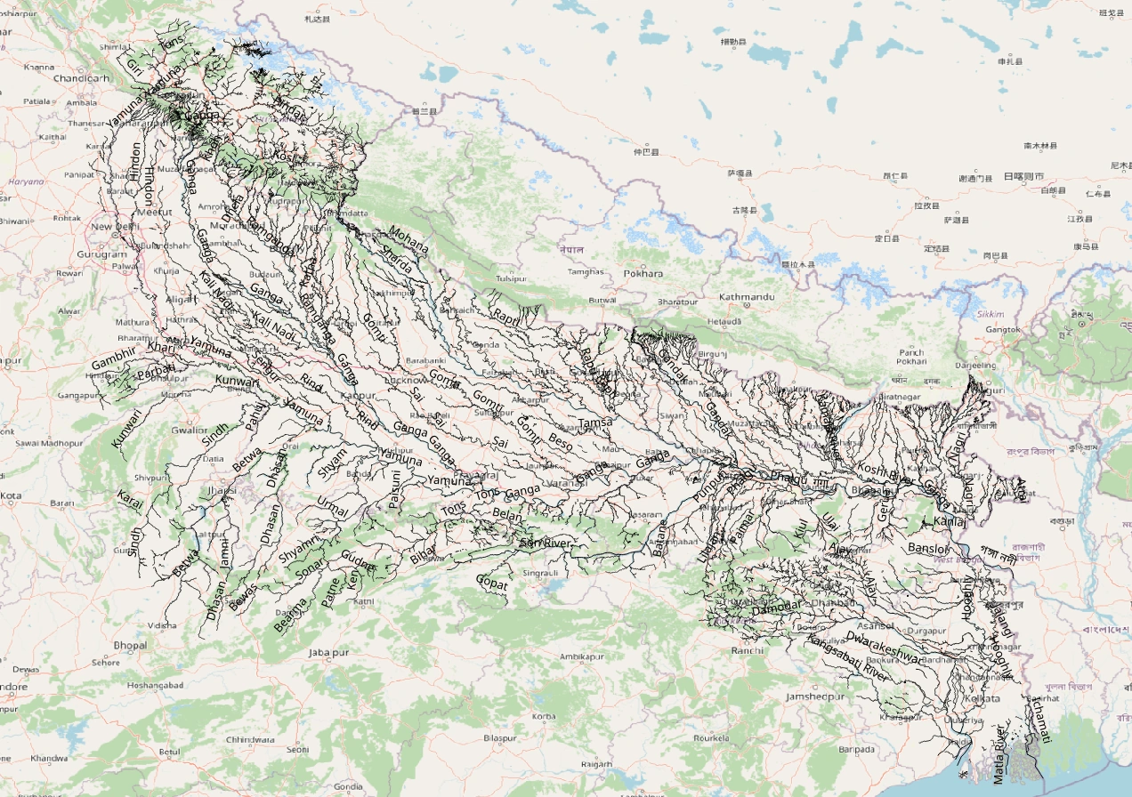
Map study
Ganga–Yamuna basin: trace Himalayan tributaries and trunk drainage. Catchment boundaries are not political borders.
- Read the source legend, scale and reference period before comparing regions.
- Connect spatial patterns to the processes discussed in this topic; this map is a study reference, not live operational data.
Credit: Heinz OSM · ODbL · sourceConverted to WebP on an opaque white background; proportionally resized without cropping. Original cartography and legend retained.
1. Basin extent and geographical significance
The Ganga drains a vast region between the Himalayas in the north and the peninsular uplands in the south. Its basin is bounded broadly by the Himalayan watershed, the Aravalli–Delhi ridge on the west, and the Vindhyan and Chota Nagpur uplands toward the south. Internationally, its catchment extends across India, Nepal, China’s Tibet region and Bangladesh. Distinguish the Ganga basin from the larger Ganga–Brahmaputra–Meghna basin, which includes separate river systems that ultimately share a deltaic outlet.
Within India, the basin extends across Uttarakhand, Uttar Pradesh, Bihar, Jharkhand, West Bengal, Delhi, Haryana, Himachal Pradesh, Rajasthan, Madhya Pradesh and Chhattisgarh. This does not mean the main Ganga channel flows through all these states: tributaries such as the Yamuna, Chambal and Son bring distant areas into its catchment.
The basin supports densely populated agricultural and urban regions. Deep alluvial soils, extensive irrigation and relatively level terrain favour rice, wheat, sugarcane and other crops. Cities including Haridwar, Kanpur, Prayagraj, Varanasi and Patna developed along the river, while Delhi and Agra lie on the Yamuna. The river also carries cultural, religious and inland-navigation significance.
- A basin includes all land draining to a river and its tributaries; a watershed or drainage divide separates neighbouring basins.
- Bank identification is made while facing downstream, not by assuming that northern tributaries are always left-bank tributaries.
- The Ganga is perennial, but its discharge varies greatly with monsoon rainfall, snow and glacier melt, groundwater inflow and water withdrawals.
2. Headwaters, confluences and course
The Bhagirathi emerges at Gaumukh, the snout of the Gangotri Glacier in Uttarakhand. The Alaknanda rises in the glacier region near the Chaukhamba massif and flows past Badrinath. Although the Bhagirathi is conventionally treated as the sacred source stream, the Alaknanda is a major hydrological headstream. Their meeting at Devprayag marks the beginning of the river named Ganga.
The Panch Prayag confluences are arranged along the Alaknanda from upstream to downstream: Vishnuprayag, Nandprayag, Karnaprayag, Rudraprayag and Devprayag. Their joining rivers are respectively the Dhauliganga, Nandakini, Pindar, Mandakini and Bhagirathi. These pairings are useful for map-based elimination questions.
After passing Rishikesh, the Ganga enters the plains at Haridwar. It traverses Uttar Pradesh and Bihar, skirts or follows parts of Jharkhand, and enters West Bengal. The Yamuna joins at Prayagraj; farther downstream, major tributaries progressively enlarge the river before it reaches the deltaic region.
In West Bengal, the river system divides into the Bhagirathi–Hooghly distributary toward the south and the main channel toward Bangladesh, where it is known as the Padma. The Padma joins the Jamuna, the main Brahmaputra channel in Bangladesh; their combined flow subsequently joins the Meghna and reaches the Bay of Bengal. The Hooghly reaches the bay separately, with Kolkata situated along its eastern bank.
- Do not confuse the Himalayan Bhagirathi headstream with the Bhagirathi distributary in West Bengal.
- Farakka Barrage diverts part of the Ganga’s flow through a feeder canal into the Bhagirathi–Hooghly system.
- The Sundarbans occupy the tidal, mangrove-covered portion of the shared Ganga–Brahmaputra–Meghna delta, not the entire delta.
Main headwater-to-sea connection
- 1. Bhagirathi and Alaknanda meet at Devprayag
- 2. Ganga enters the plains at Haridwar
- 3. Yamuna and other major tributaries augment the flow
- 4. Bhagirathi–Hooghly branches toward the southern delta
- 5. Main channel enters Bangladesh as the Padma
- 6. Padma–Jamuna waters join the Meghna and reach the Bay of Bengal
3. Tributaries and drainage relationships
The Yamuna originates from the Yamunotri Glacier region on the Bandarpunch massif. It flows through the western part of the Ganga basin and joins the Ganga at Prayagraj. Its tributaries include the Tons from the Himalayas and the Chambal, Sind, Betwa and Ken from the peninsular uplands. Consequently, these peninsular rivers are tributaries of the Ganga system, but not direct tributaries of the Ganga main stem.
Among the left-bank tributaries, the Ramganga rises in the Garhwal Himalayas and joins near Kannauj. The Gomti is a plains-origin river associated with the Gomat Taal or Fulhar lake area in Pilibhit district. The Ghaghara, known as the Karnali in Nepal, drains a large Himalayan catchment and meets the Ganga near Chhapra. The Gandak enters the plains near Valmikinagar and joins near Sonpur, opposite the Patna region.
The Kosi drains eastern Nepal and adjoining Himalayan areas and joins the Ganga near Kursela in Bihar. Its large sediment load, extensive alluvial fan and shifting channels make it particularly flood-prone. The Son, a major right-bank tributary, rises near Amarkantak and meets the Ganga upstream of Patna near Maner. The Damodar drains the Chota Nagpur Plateau and belongs to the Hooghly drainage system.
- Direct right-bank tributaries: Yamuna, Son and Punpun are important examples.
- Major left-bank tributaries in broad west-to-east order: Ramganga, Gomti, Ghaghara, Gandak and Kosi.
- Chambal ravines reflect severe gully erosion in parts of the Yamuna–Ganga basin.
- Not every Ganga tributary is glacier-fed: the Gomti and peninsular tributaries have different source environments.
| River | Source region | Joins | Exam distinction |
|---|---|---|---|
| Yamuna | Yamunotri region | Ganga at Prayagraj | Direct right-bank tributary |
| Chambal | Janapav hills, Madhya Pradesh | Yamuna | Indirect tributary of the Ganga |
| Gandak | Nepal Himalayas | Ganga near Sonpur | Direct left-bank tributary |
| Son | Amarkantak region | Ganga near Maner | Peninsular right-bank tributary |
| Damodar | Chota Nagpur Plateau | Hooghly | Part of the distributary drainage system |
4. River processes, groundwater and the delta
The Himalayan reaches have steep gradients, narrow valleys and strong erosional capacity. As the river enters the plains, its gradient declines and sediment deposition becomes increasingly important. Meanders, floodplains, natural levees, abandoned channels and oxbow lakes develop through lateral migration and flooding. Khadar refers to relatively recent floodplain alluvium, while bhangar generally denotes older alluvial surfaces.
Monsoon rainfall supplies the largest seasonal pulse of water across much of the basin. Himalayan snow and glacier melt contribute to headwater flow, especially before and during the warm season, but describing the entire Ganga as predominantly glacier-fed is misleading. Groundwater sustains dry-season baseflow in many reaches, while excessive pumping can reduce river–aquifer support.
At the coast, sediment deposition interacts with tides, waves, subsidence and sea-level change to produce a low-lying delta crossed by distributaries and tidal creeks. The Sundarbans mangroves provide coastal protection and wildlife habitat. Upstream sediment trapping, altered freshwater flows, salinity intrusion and cyclones affect delta resilience.
- Floods arise from combinations of heavy rainfall, tributary synchronisation, sedimentation, channel change and floodplain encroachment.
- Riverbank erosion is distinct from temporary inundation and can permanently remove settlements or agricultural land.
- Arsenic contamination in parts of the basin’s groundwater is largely geogenic; it should not be attributed solely to industrial discharge.
5. Water use, conservation and governance
Major interventions include the Upper Ganga Canal at Haridwar, Tehri Dam on the Bhagirathi and Farakka Barrage in West Bengal. They serve irrigation, hydropower, water supply or flow-management objectives, but can also alter sediment transport, ecological connectivity and seasonal discharge. National Waterway 1 extends along the Ganga–Bhagirathi–Hooghly system between Prayagraj and Haldia, covering approximately 1,620 km.
Pollution pressures include untreated municipal sewage, industrial effluents, agricultural runoff and solid waste. The Ganga Action Plan began in 1985. Namami Gange, launched in 2014, adopts a broader approach covering sewage infrastructure, industrial pollution control, river-surface cleaning, biodiversity, afforestation and public participation. The National Mission for Clean Ganga is a key implementing institution; the 2016 Ganga authorities order was issued under the Environment (Protection) Act, 1986.
Conservation requires both water quality and adequate ecological flows. The Ganges river dolphin, India’s National Aquatic Animal, depends on connected freshwater habitats. Management must therefore go beyond sewage treatment to protect wetlands, tributaries and floodplains. Transboundary cooperation also matters: the 1996 India–Bangladesh treaty provides for sharing Ganga waters at Farakka during the lean season.
- A barrage primarily regulates and diverts flow; it is not equivalent to a large storage dam.
- Assess river projects through basin-wide and cumulative impacts rather than only the immediate project site.
- For Prelims, connect locations with tributary hierarchy, protected species, navigation routes and international water-sharing arrangements.
Real-world case studies
Kosi embankment breach, 2008
In August 2008, the Kosi breached its eastern embankment near Kusaha in Nepal and diverted into an older course, causing extensive flooding in Bihar. The disaster illustrates the importance of channel migration, sediment accumulation and embankment maintenance, alongside rainfall-based flood forecasting.
Dolphin conservation in Bihar
Vikramshila Gangetic Dolphin Sanctuary covers about 60 km of the Ganga between Sultanganj and Kahalgaon in Bihar. Dolphin conservation here links environmental flows, fish availability, fishing-net entanglement and pollution control, demonstrating why aquatic biodiversity requires management of the functioning river rather than isolated protected sites.
Previous year questions
UPSC Prelims 2014
Which of the following rivers are tributaries of the Brahmaputra? 1. Dibang 2. Kameng 3. Lohit
- A. 1 only
- B. 2 and 3 only
- C. 1 and 3 only
- D. 1, 2 and 3
Practice questions
Practice MCQ 1
Which pairing of a Panch Prayag confluence with its joining river is incorrect?
- A. Vishnuprayag — Dhauliganga
- B. Nandprayag — Nandakini
- C. Karnaprayag — Mandakini
- D. Devprayag — Bhagirathi
Practice MCQ 2
Consider the following rivers: 1. Son 2. Chambal 3. Gandak 4. Betwa. Which join the Ganga main stem directly?
- A. 1 and 3 only
- B. 2 and 4 only
- C. 1, 2 and 3 only
- D. 1, 3 and 4 only
Practice MCQ 3
With reference to the Ganga system, consider the following statements: 1. Every perennial tributary of the Ganga originates in a glacier. 2. Farakka Barrage facilitates diversion of water toward the Bhagirathi–Hooghly. 3. Groundwater can contribute to river flow during the dry season. Which statements are correct?
- A. 1 and 2 only
- B. 2 and 3 only
- C. 1 and 3 only
- D. 1, 2 and 3
Mains practice · Explain how the contrasting characteristics of Himalayan and peninsular tributaries shape the Ganga system. Discuss the implications for basin-wide water management. Answer in 250 words.
- Introduce the integrated basin linking Himalayan headwaters, peninsular uplands and an alluvial plain.
- Compare relief, rainfall dependence, meltwater contribution, sediment loads and seasonal discharge.
- Use Ghaghara, Kosi, Yamuna, Chambal and Son as examples.
- Explain floods, channel migration, groundwater interactions and sediment delivery to the delta.
- Discuss irrigation withdrawals, reservoirs, ecological flows and pollution.
- Recommend interstate and international coordination, floodplain protection and tributary-level restoration.
Further reading
- NCERT, India: Physical Environment, Class XI, chapter on Drainage System.
- NCERT, Contemporary India I, Class IX, chapter on Drainage.
- Central Water Commission and ISRO, River Basin Atlas of India.
- India-WRIS: Ganga basin maps and water-resource information.
- National Mission for Clean Ganga: Namami Gange programme and annual reports.
- Inland Waterways Authority of India: National Waterway 1.
Preparing for UPSC Civil Services? Get classroom teaching, answer-writing evaluation and mentorship at Pragnya IAS Academy, Ashok Nagar — see why aspirants choose us for IAS coaching in Hyderabad.