
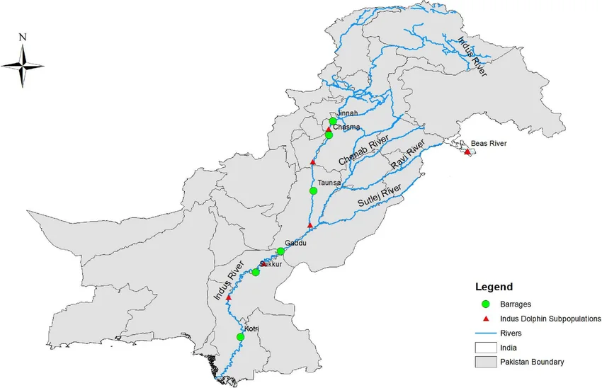
Indus river dolphin subpopulations: an ecological perspective on the transboundary Indus system.
Credit: Shiana1 · CC0 · sourceResized and converted to WebP; uncropped.
1. Basin setting and the course of the Indus
The Indus belongs to the Himalayan drainage system and forms one of Asia’s major transboundary river basins. Its catchment extends across the Tibetan Plateau, the Himalaya, Karakoram and Hindu Kush, and the plains of Pakistan. China contains its headwater region; India contains important upper catchments; Afghanistan contributes through the Kabul river system; and Pakistan contains most of the lower basin. In India, the basin includes parts of Ladakh, Jammu and Kashmir, Himachal Pradesh, Punjab, Haryana and Rajasthan. A natural drainage basin should not be equated with the larger area served by inter-basin canals.
The river rises in Tibet near Lake Manasarovar, where its headwaters are associated with the name Sengge Zangbo. It enters India in the Demchok sector of Ladakh and flows broadly northwest through a high-altitude, relatively dry landscape. Near Nimmu, downstream of Leh, the Zanskar joins it from the left. The Shyok joins farther downstream in the region administered by Pakistan.
Near the Nanga Parbat massif, the Indus cuts a spectacular gorge and turns towards the southwest. It eventually enters the plains of Pakistan, receives the combined Punjab rivers through the Panjnad near Mithankot, and flows across Sindh into the Arabian Sea southeast of Karachi. Its delta contains tidal creeks, mudflats and mangroves. The main Indus does not flow through the Indian state of Punjab.
- Map sequence: Tibetan headwaters → Ladakh → upper Indus gorges → Pakistan plains → Sindh delta.
- Important upper tributaries include Zanskar, Shyok, Shigar and Gilgit; the Kabul joins near Attock.
- River banks are identified while facing downstream, not by assuming that east always means left.
Timeline
1947
Partition divided the Punjab irrigation network between India and Pakistan, creating cross-border water-management challenges.
1960
The Indus Waters Treaty was signed at Karachi on 19 September.
April 2025
India announced that the treaty would be held in abeyance following the Pahalgam terrorist attack.
2. The five Punjab rivers and their confluences
The Jhelum rises at Verinag spring near the foot of the Pir Panjal in Jammu and Kashmir. It flows through the Kashmir Valley and Srinagar and passes through Wular Lake before entering a gorge towards Pakistan-administered territory. The Kishanganga, called Neelum downstream, is an important tributary. The Jhelum eventually joins the Chenab near Trimmu in Pakistan. Wular is therefore associated with the Jhelum, not the Chenab or Ravi.
The Chenab is formed by the union of the Chandra and Bhaga at Tandi in Himachal Pradesh’s Lahaul region. Its upper course is also called Chandrabhaga. It flows through the Jammu region before entering Pakistan. The Ravi rises in the Himachal Himalaya, passes through the Chamba region and subsequently joins the Chenab in Pakistan. Chandra–Bhaga–Chenab and Verinag–Jhelum are particularly useful source associations.
The Beas originates near Beas Kund in the vicinity of Rohtang Pass. It flows through the Kullu Valley and joins the Sutlej at Harike in Punjab. Unlike the other four Punjab rivers, its entire course lies within India. The Sutlej originates in Tibet near Rakshastal, enters India near Shipki La in Himachal Pradesh, and flows towards the Punjab plains. Its Tibetan headwaters distinguish it from rivers originating on the southern Himalayan slopes.
Downstream, the Jhelum and Ravi join the Chenab, while the Beas joins the Sutlej. The Sutlej then meets the Chenab system, and the combined lower channel is called the Panjnad. It joins the Indus near Mithankot. Thus, the five Punjab rivers do not independently enter the Indus.
- Punjab means land of five waters; the historical region extends across the present India–Pakistan boundary.
- Doabs are interfluves between two rivers: Bist Doab lies between Beas and Sutlej, Bari between Beas and Ravi, and Rechna between Ravi and Chenab.
- Harike wetland is located at the Beas–Sutlej confluence.
How the Punjab rivers reach the Indus
- 1. Chandra and Bhaga unite to form the Chenab.
- 2. Jhelum and Ravi join the Chenab downstream in Pakistan.
- 3. Beas joins Sutlej at Harike in India.
- 4. Sutlej meets the Chenab system; the combined lower channel is called Panjnad.
- 5. Panjnad joins Indus near Mithankot; Indus reaches the Arabian Sea.
3. Drainage evolution and seasonal behaviour
The Indus and Sutlej are standard examples of antecedent drainage: their courses are understood to predate major phases of Himalayan uplift, with river incision helping maintain routes across rising terrain. Their deep gorges are important evidence for this interpretation. Antecedent drainage differs from superimposed drainage, in which a river establishes its pattern on a former covering surface and subsequently cuts into underlying structures.
The system is perennial, but perennial does not mean uniform discharge. Snowmelt, glacier melt, rainfall and groundwater contributions sustain its rivers in different proportions. Winter precipitation from western disturbances builds seasonal snow storage in the western Himalaya and adjoining high mountains. Spring and summer warming release meltwater, while the southwest monsoon strongly affects several southern and eastern tributary catchments.
The high-altitude upper Indus includes cold-desert areas because surrounding mountain barriers restrict moisture penetration. Lower reaches cross semi-arid and arid plains where evaporation is substantial. Floods can result from intense rainfall, rapid melt, landslide-dam failure or combinations of processes. Climate change alters the timing of meltwater supply and increases risks from glacial lakes, but glacier behaviour is not uniform: parts of the Karakoram have shown patterns different from widespread Himalayan glacier retreat.
- Drainage pattern varies by scale: a broad dendritic network can coexist with structurally guided mountain valleys.
- Sediment transport links mountain erosion with reservoirs, alluvial plains and delta maintenance.
| River | Origin or formation | Important association | Treaty category |
|---|---|---|---|
| Jhelum | Verinag spring | Srinagar; Wular Lake; joins Chenab | Western |
| Chenab | Chandra–Bhaga confluence at Tandi | Baglihar; Salal | Western |
| Ravi | Himachal Himalaya | Chamba; Ranjit Sagar Dam | Eastern |
| Beas | Beas Kund near Rohtang Pass | Pong Dam; joins Sutlej at Harike | Eastern |
| Sutlej | Tibet near Rakshastal | Shipki La; Bhakra Dam | Eastern |
4. Water use, infrastructure and environmental concerns
The basin supports intensive irrigated agriculture, major settlements and hydropower generation. In India, Bhakra Dam and Gobind Sagar reservoir lie on the Sutlej; Pong Dam and Maharana Pratap Sagar reservoir lie on the Beas; and Ranjit Sagar, or Thein Dam, lies on the Ravi. Salal, Baglihar and Dul Hasti are associated with the Chenab. These river–project pairs are frequent sources of objective-question distractors.
Canals redistribute water beyond natural river valleys. The Indira Gandhi Canal takes water from Harike through its feeder system to northwestern Rajasthan. Such transfers support agriculture and settlements but can also create waterlogging and soil salinity where drainage is inadequate. Irrigation-dependent cropping and groundwater over-extraction in northwestern India add pressures that cannot be understood through river discharge alone.
Reservoir sedimentation reduces useful storage, while dams and diversions alter downstream flow and sediment regimes. Reduced freshwater and sediment delivery to the lower Indus contributes to delta degradation and seawater intrusion. Environmental management therefore requires attention to wetlands, aquatic biodiversity, floodplains and downstream livelihoods, rather than treating every unit of river water as available for diversion.
- Pakistan’s Tarbela Dam is on the Indus; Mangla Dam is on the Jhelum.
- Run-of-river hydropower usually involves limited pondage or storage; it does not necessarily mean an absence of dams or downstream impacts.
5. Indus Waters Treaty and examination relevance
India and Pakistan signed the Indus Waters Treaty in Karachi on 19 September 1960, following negotiations facilitated by the World Bank. Jawaharlal Nehru and Ayub Khan signed for their respective countries. The treaty divides river-use rights rather than partitioning the entire basin into exclusive geographical territories. The World Bank is a signatory for specified purposes, not a general authority controlling basin waters.
The eastern rivers—Ravi, Beas and Sutlej—were allocated for India’s unrestricted use under treaty provisions. The western rivers—Indus, Jhelum and Chenab—were allocated principally to Pakistan, while India retained specified rights involving domestic use, non-consumptive use, agriculture and hydropower, subject to conditions. Therefore, the assertion that India cannot use western-river water at all is incorrect.
The treaty established a Permanent Indus Commission and procedures involving the commission, a Neutral Expert and a Court of Arbitration for different categories of disagreement. In April 2025, following the Pahalgam terrorist attack, India announced that the treaty would be held in abeyance. For examination purposes, separate the treaty’s original provisions from subsequent diplomatic developments, and verify the latest official position. An announcement does not itself create the physical infrastructure needed to divert or store entire river flows.
- Eastern and western are treaty categories, not labels for the bank from which a tributary joins.
- Questions concerning hydropower disputes commonly involve design, storage and operational conditions.
Indus Drainage and River Dolphin Habitat
The Indus river dolphin connects drainage geography with freshwater ecology. Endemic to the Indus river system, it illustrates how a river basin functions as a network of aquatic habitats rather than simply a main channel and its tributaries. Most surviving populations occur in Pakistan, while India supports a small population in the Beas, a tributary of the Sutlej. This makes the dolphin relevant to both the wider Indus basin and conservation within India’s Punjab plains.
Subpopulations are important because barrages and altered river flows can divide suitable habitat and restrict movement between river stretches. Water abstraction, pollution and accidental entanglement in fishing gear create additional pressures. Conservation therefore requires attention to environmental flows, habitat connectivity and water quality alongside irrigation and hydropower demands. The supplied metadata identifies the image as concerning dolphin subpopulations, but does not establish its survey date, population estimates or the completeness of mapped distribution. Treat it as an ecological illustration, not as definitive evidence of present-day abundance or of dolphin occurrence throughout every Indus tributary.
- Prelims distinction: the Beas belongs geographically to the Indus drainage system but is classified as an eastern river under the Indus Waters Treaty.
- Species distinction: the Indus river dolphin and Ganges river dolphin are distinct species; freshwater habitat alone does not make their distributions interchangeable.
- Mains linkage: treaty allocation and ecological connectivity address different questions. Assess river management through basin geography, flow regulation and biodiversity needs without assuming allocation guarantees adequate habitat.
Real-world case studies
Harike: confluence, wetland and water distribution
Harike in Punjab combines three geographical functions: the Beas–Sutlej confluence, a barrage-linked wetland designated as a Ramsar site in 1990, and a major irrigation diversion point. It illustrates how infrastructure can create important wetland habitats while requiring management of pollution, siltation and competing water demands.
The lower Indus delta
The Indus delta in Sindh supports mangroves and fishing communities. Upstream regulation and abstraction have reduced freshwater and sediment reaching the coast, contributing to salinity intrusion and ecosystem stress. Mangrove restoration is valuable, but maintaining delta functions also requires attention to freshwater flows and sediment supply.
Previous year questions
UPSC Prelims 2021
In the Indus river system, three of the following rivers pour into one river that subsequently joins the Indus. Which is that river?
- A. Chenab
- B. Jhelum
- C. Ravi
- D. Sutlej
Practice questions
Practice MCQ 1
Consider the following pairs: 1. Wular Lake—Jhelum; 2. Harike confluence—Beas and Sutlej; 3. Tandi confluence—Ravi and Chenab. Which pairs are correctly matched?
- A. 1 only
- B. 1 and 2 only
- C. 2 and 3 only
- D. 1, 2 and 3
Practice MCQ 2
Under the original provisions of the Indus Waters Treaty, which statement is correct?
- A. India is prohibited from all uses of the western rivers.
- B. Ravi, Beas and Sutlej constitute the eastern rivers.
- C. The World Bank operates all major basin reservoirs.
- D. Jhelum and Ravi constitute two of the western rivers.
Practice MCQ 3
Consider the following statements: 1. The Beas flows entirely within India. 2. The Sutlej enters India near Shipki La. 3. The Kabul is a tributary of the Jhelum. Which statements are correct?
- A. 1 and 2 only
- B. 2 only
- C. 1 and 3 only
- D. 1, 2 and 3
Mains practice · Explain how the physical geography of the Indus basin shapes its water availability and management challenges. Discuss with reference to India. Answer in 250 words.
- Locate the transboundary basin and distinguish mountain catchments from arid downstream plains.
- Explain snowmelt, glacier melt, western disturbances and monsoon contributions.
- Connect steep relief with hydropower potential, erosion and sedimentation.
- Discuss irrigation, canal transfers, groundwater pressure and salinity.
- Outline treaty allocations and the need to distinguish legal rights from infrastructure capacity.
- Recommend efficient irrigation, flood forecasting, sediment management, ecological flows and reliable hydrological data.
Further reading
- NCERT, India: Physical Environment, Class XI, chapter on Drainage System.
- NCERT, Contemporary India–I, Class IX, chapter on Drainage.
- Central Water Commission and ISRO, River Basin Atlas of India.
- India-WRIS portal: Indus basin maps and water-resources information.
- World Bank: Indus Waters Treaty text and explanatory material.
- Ministry of External Affairs: official statements on Indus Waters Treaty developments.
- https://commons.wikimedia.org/wiki/File:The-Indus-River-Dolphin-subpopulations.png
Preparing for UPSC Civil Services? Get classroom teaching, answer-writing evaluation and mentorship at Pragnya IAS Academy, Ashok Nagar — see why aspirants choose us for IAS coaching in Hyderabad.