

Vice Admiral Krishna Swaminathan, COS, WNC and the Chairman, Regional Contingency Committee (West), visited the ICW Processing Complex of ONGC in Mumbai High on 11 November 2021. The visit was aimed a
Credit: Indian Navy · GODL-India · source

Manganese nodule, cut
Credit: Hannes Grobe · CC BY-SA 4.0 · source
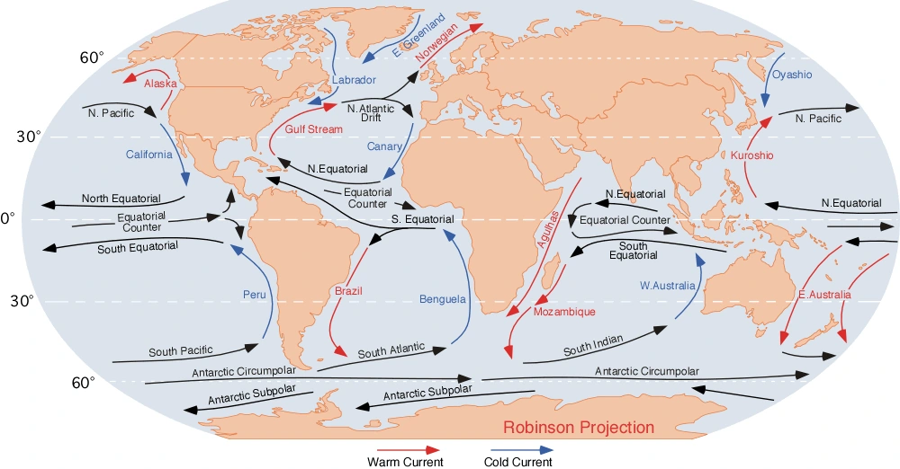
Map study
Global ocean currents: compare warm and cold current pathways and major gyres. Arrow directions and legend matter; local and seasonal currents can differ.
- Read the source legend, scale and reference period before comparing regions.
- Connect spatial patterns to the processes discussed in this topic; this map is a study reference, not live operational data.
Credit: Dr. Michael Pidwirny · Public domain · sourceConverted to WebP on an opaque white background; proportionally resized without cropping. Original cartography and legend retained.
1. Classification and geographical controls
Marine resources can be classified as living, non-living and ecosystem-service resources. Living resources include fish, crustaceans, molluscs, seaweeds and microorganisms. Non-living resources include petroleum, natural gas, dissolved salts, seabed minerals and renewable energy. Ecosystem services include coastal protection, carbon storage, nutrient cycling and recreation. Marine genetic resources also offer potential applications in pharmaceuticals, industrial enzymes and biotechnology.
Distribution depends strongly on bathymetry, sunlight, nutrient supply and geological history. The continental shelf is relatively shallow and receives river-borne nutrients and sediments. Sunlight supports photosynthesis, while mixing can replenish nutrients in surface waters. Many shelf seas consequently support valuable fisheries. Thick sedimentary sequences in suitable geological structures also favour the formation and accumulation of oil and natural gas.
Biological richness should not be equated with uniformly high ocean productivity. Much of the tropical and subtropical open ocean is nutrient-poor because stratification restricts vertical mixing. Productive waters occur especially where nutrients reach the sunlit zone through upwelling, seasonal overturning or river discharge. Resource assessment therefore requires attention to local oceanographic conditions rather than latitude alone.
- Renewable does not mean inexhaustible: fisheries and seaweed stocks can decline when extraction exceeds regeneration.
- Mineral deposits and fossil fuels are non-renewable on human timescales.
- Coastal ecosystems provide benefits that may be economically valuable even without extraction.
2. Fisheries, mariculture and biological resources
Phytoplankton form the base of most marine food webs. Their growth depends on light and nutrients such as nitrate, phosphate and, for diatoms, silicate. Zooplankton transfer this production to fish and larger animals. Coastal upwelling along Peru–Chile, California, northwestern Africa and southwestern Africa sustains important fisheries. Wind-driven offshore transport of surface water allows colder, nutrient-rich subsurface water to rise.
Traditional fishing grounds include the Grand Banks near Newfoundland, the North Sea and the waters around Japan. Broad shelves, mixing and nutrient supply help explain their productivity. Where currents meet, fronts can concentrate organisms, but the meeting of warm and cold currents is not by itself a sufficient explanation for rich fisheries. Fish abundance also depends on breeding conditions, habitat quality and fishing pressure.
India’s marine fisheries operate along both mainland coasts and island territories. Sardines, mackerel, tuna, anchovies, shrimps and other species support livelihoods, processing and trade. Capture fisheries harvest naturally occurring stocks, whereas mariculture cultivates organisms in marine or coastal environments. Examples include mussel and oyster culture, marine cage farming and seaweed cultivation. Shrimp aquaculture is frequently practised in brackish-water ponds and should not be confused with offshore fishing.
Management challenges include overfishing, juvenile catch, destructive gear, bycatch and habitat degradation. Seasonal closures, mesh-size regulation, stock assessment and protection of breeding grounds support conservation. The maximum sustainable yield concept links harvest to stock regeneration, but uncertainty and ecosystem interactions justify precautionary management. Pradhan Mantri Matsya Sampada Yojana, launched in 2020, addresses fisheries development, infrastructure, productivity and value chains.
How coastal upwelling supports fisheries
- 1. Alongshore winds drive net offshore transport of surface water
- 2. Colder subsurface water rises to replace displaced water
- 3. Nutrients enter the sunlit surface layer
- 4. Phytoplankton production increases where other conditions are favourable
- 5. Food-web production supports zooplankton and fish
- 6. Sustainable harvest depends on stock condition and fishing pressure
3. Minerals, hydrocarbons and freshwater
Offshore petroleum and natural gas occur mainly in sedimentary basins along continental margins. Mumbai High in the Arabian Sea is a major Indian offshore oilfield; the Krishna–Godavari basin is important for offshore hydrocarbons on the eastern margin. Exploration and production require costly infrastructure and involve risks such as oil spills, methane leakage and disturbance of coastal and marine habitats.
Marine minerals occur in several distinct settings. Polymetallic nodules lie on deep-ocean abyssal plains and contain manganese and iron, with economically interesting quantities of nickel, copper and cobalt. Polymetallic sulphides form around hydrothermal systems, commonly near mid-ocean ridges and back-arc basins, and may contain copper, zinc, gold and silver. Cobalt-rich ferromanganese crusts develop on exposed hard surfaces, especially seamounts. These deposits must not be treated as interchangeable.
Coastal placer deposits are concentrations of heavy minerals produced by weathering, river transport and wave sorting. Indian beach sands contain minerals such as ilmenite, rutile, zircon and monazite; monazite is significant for its thorium and rare-earth content. Seawater also supplies common salt and compounds of magnesium and bromine. Desalination converts seawater into freshwater, commonly through reverse osmosis, but entails energy demand, costs and concentrated-brine disposal.
Gas hydrates are ice-like crystalline solids in which water molecules trap gas, predominantly methane. They occur under high-pressure, low-temperature conditions in marine sediments and also in permafrost regions. India has investigated hydrate occurrences in its offshore basins. Their presence does not establish commercial recoverability: extraction faces technological, economic and environmental challenges, including potential methane release and sediment instability.
| Resource | Typical setting | Important distinction |
|---|---|---|
| Petroleum and natural gas | Continental-margin sedimentary basins | Require suitable source, reservoir and trapping conditions |
| Polymetallic nodules | Deep-ocean abyssal plains | Loose concretions on or partly buried in seabed sediments |
| Polymetallic sulphides | Hydrothermal vents and associated deposits | Form through precipitation from mineral-rich fluids |
| Cobalt-rich crusts | Exposed seamount rock surfaces | Attached crusts rather than loose nodules |
| Heavy-mineral placers | Beaches and nearshore deposits | Concentrated by sediment sorting |
4. Ocean energy and ecosystem services
Tidal energy uses predictable tidal movements. Barrage systems exploit the difference in water level across an enclosure, while tidal-stream turbines use moving currents. India’s Gulf of Khambhat and Gulf of Kachchh are often identified for tidal potential. Wave energy captures wind-generated surface-wave motion; its suitability depends on wave climate, device efficiency and survival under storm conditions.
Ocean thermal energy conversion uses the temperature difference between warm surface water and cold deep water, generally requiring a difference of about 20°C for practical operation. Tropical oceans offer favourable conditions, although pumping costs and engineering complexity constrain deployment. Offshore wind is ocean-based energy, but its immediate source is atmospheric motion rather than tides or seawater heat. India has prioritised offshore wind development off Gujarat and Tamil Nadu.
Mangroves, seagrass meadows and tidal marshes store blue carbon in biomass and sediments. They also provide nursery habitats, reduce coastal erosion and support livelihoods. Coral reefs sustain biodiversity, fisheries and tourism while attenuating wave energy. Their conservation is therefore resource management, not merely wildlife protection. Pollution, dredging, warming, coral bleaching and ocean acidification can reduce these services.
5. Maritime rights and sustainable utilisation
The United Nations Convention on the Law of the Sea, adopted in 1982 and in force since 1994, provides the principal legal framework. Territorial waters extend up to 12 nautical miles from the baseline. The contiguous zone may extend to 24 nautical miles, while the exclusive economic zone may extend to 200 nautical miles. Within the EEZ, the coastal state has sovereign rights over exploration, exploitation, conservation and management of natural resources, subject to other states’ lawful freedoms.
Continental-shelf rights concern the seabed and subsoil, not the overlying water column. A coastal state’s legal continental shelf can extend beyond 200 nautical miles where UNCLOS conditions are met. The seabed beyond national jurisdiction is called the Area; its mineral resources are the common heritage of humankind. The International Seabed Authority, headquartered in Kingston, Jamaica, organises and controls mineral-related activities there. An exploration contract does not itself authorise commercial mining.
India’s Deep Ocean Mission, approved in 2021 under the Ministry of Earth Sciences, includes deep-sea technology, mineral exploration, biodiversity studies and ocean-climate services. Samudrayaan envisages human exploration using the MATSYA 6000 submersible. Such research can improve knowledge, but deep-sea mining raises concerns about sediment plumes, noise, habitat loss and very slow ecosystem recovery.
A sustainable blue economy combines economic opportunity with ecosystem protection and equitable livelihoods. Priorities include marine spatial planning, ecosystem-based fisheries management, pollution control, disaster resilience and stronger monitoring of illegal, unreported and unregulated fishing. Scientific resource estimates, environmental assessment and consultation with coastal communities should precede large-scale extraction.
Real-world case studies
Peru: upwelling and El Niño
The Humboldt Current system supports the highly productive Peruvian anchoveta fishery. During strong El Niño events, a deeper thermocline and reduced nutrient delivery can weaken productivity and alter fish distribution. The example shows how climate variability interacts with fishing pressure to affect a major marine resource.
India’s Central Indian Ocean Basin exploration
India signed a polymetallic-nodule exploration contract with the International Seabed Authority in 2002. Its exploration area in the Central Indian Ocean Basin covers 75,000 square kilometres. The programme illustrates the distinction between identifying mineral potential, developing extraction technology and securing legal and environmental approval for commercial exploitation.
Previous year questions
No source-linked PYQ is available here yet. Use the practice questions below.
Practice questions
Practice MCQ 1
Consider the following pairs: 1. Polymetallic nodules — Abyssal plains; 2. Cobalt-rich ferromanganese crusts — Exposed seamount surfaces; 3. Polymetallic sulphides — Hydrothermal systems. How many pairs are correctly matched?
- A. Only one
- B. Only two
- C. All three
- D. None
Practice MCQ 2
With reference to maritime resource rights, consider the following statements: 1. Continental-shelf rights include sovereign rights over all fish in the overlying water column. 2. An EEZ may extend up to 200 nautical miles from the baseline. 3. The International Seabed Authority regulates mineral-related activities in the Area. Which statements are correct?
- A. 1 and 2 only
- B. 2 and 3 only
- C. 1 and 3 only
- D. 1, 2 and 3
Practice MCQ 3
Which statement best explains the high productivity of many coastal upwelling zones?
- A. Rising deep water supplies nutrients to the sunlit layer
- B. Cold water eliminates the need for sunlight in primary production
- C. High salinity directly supplies all nutrients required by phytoplankton
- D. Upwelling prevents all seasonal changes in fish populations
Mains practice · Explain the geographical controls on the distribution of marine resources. Discuss the opportunities and ecological constraints associated with their utilisation by India. Answer in 250 words.
- Classify living, mineral, energy and ecosystem-service resources.
- Explain shelves, upwelling, sedimentary basins, abyssal plains and hydrothermal systems.
- Use Indian examples: marine fisheries, Mumbai High, offshore wind and Central Indian Ocean Basin nodules.
- Identify livelihood, energy-security, mineral-security and research opportunities.
- Discuss overfishing, pollution, habitat damage, extraction costs and uncertain deep-sea impacts.
- Conclude with UNCLOS-compliant, science-based and community-sensitive blue-economy planning.
Further reading
- NCERT, Class XI, Fundamentals of Physical Geography: Water (Oceans) and Movements of Ocean Water.
- United Nations Division for Ocean Affairs and the Law of the Sea: UNCLOS text, especially Parts V, VI and XI.
- Ministry of Earth Sciences: Deep Ocean Mission and annual reports.
- International Seabed Authority: exploration contracts and marine mineral resources.
- Department of Fisheries, Government of India: Handbook on Fisheries Statistics and PMMSY guidelines.
- FAO: The State of World Fisheries and Aquaculture 2024.
Preparing for UPSC Civil Services? Get classroom teaching, answer-writing evaluation and mentorship at Pragnya IAS Academy, Ashok Nagar — see why aspirants choose us for IAS coaching in Hyderabad.