

Ocean Currents and Sea Ice from Atlas of World Maps, United States Army Service Forces, Army Specialized Training Division. Army Service Forces Manual M-101 (1943).
Credit: US army · Public domain · source

Small, single-celled phytoplankton play a key role in the marine food chain. They convert sunlight, carbon dioxide and nutrients into carbohydrates on which nearly all life in the ocean depends. In mo
Credit: European Space Agency · CC BY-SA 3.0 igo · source
Map study
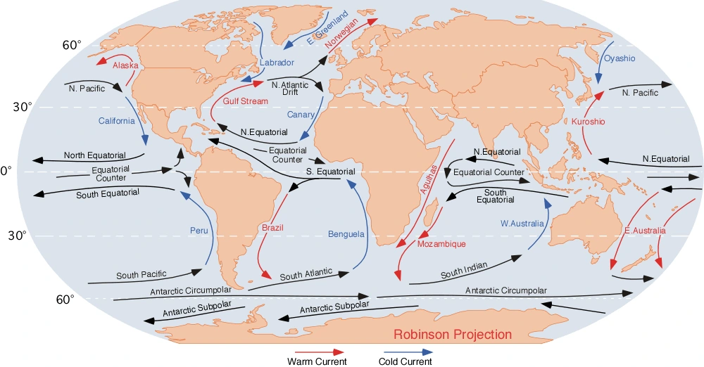
Global ocean currents: compare warm and cold current pathways and major gyres. Arrow directions and legend matter; local and seasonal currents can differ.
- Read the source legend, scale and reference period before comparing regions.
- Connect spatial patterns to the processes discussed in this topic; this map is a study reference, not live operational data.
Credit: Dr. Michael Pidwirny · Public domain · sourceConverted to WebP on an opaque white background; proportionally resized without cropping. Original cartography and legend retained.
Map study
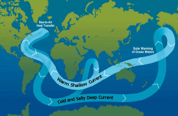
Global overturning circulation: distinguish surface and deep return flow. This conveyor pathway is a simplified model, not an exact current-speed map.
- Read the source legend, scale and reference period before comparing regions.
- Connect spatial patterns to the processes discussed in this topic; this map is a study reference, not live operational data.
Credit: Thomas Splettstoesser · Public domain · sourceConverted to WebP on an opaque white background; proportionally resized without cropping. Original cartography and legend retained.
1. Meaning, classification and geographical significance
An ocean current is a sustained movement of seawater in a broadly identifiable direction. Unlike ordinary wind-generated waves, which primarily transmit energy through oscillatory motion, currents transport water masses. They occur at the surface and at depth, horizontally and vertically, and over scales ranging from coastal streams to entire ocean basins. Their speed and position vary seasonally and over longer climatic timescales.
Currents may be classified as surface or deep, warm or cold, and permanent or seasonally reversing. Warm currents generally carry relatively warmer water towards higher latitudes, while cold currents commonly carry cooler water towards lower latitudes. These are useful patterns rather than universal rules. A warm current need not be warm in absolute terms: it is warmer than the neighbouring waters at comparable latitudes.
Surface circulation is strongly influenced by winds, whereas deep circulation is closely associated with density differences and water-mass formation. However, the two systems are interconnected: winds, tides, mixing and buoyancy changes collectively sustain ocean circulation. Vertical movements include upwelling, which brings subsurface water upwards, and downwelling, which carries surface water downwards. These movements connect ocean productivity with heat and carbon storage.
- Current names often reflect nearby coasts, regions or explorers: Brazil, Labrador, Canary and Humboldt.
- For map questions, identify the ocean basin, hemisphere and boundary before deciding a current’s direction and thermal character.
2. Forces controlling ocean circulation
Prevailing winds transfer momentum to the sea through friction. Trade winds drive the North and South Equatorial Currents mainly westwards, while mid-latitude westerlies help drive eastward flows. Winds also pile water against continental margins, creating sea-surface slopes and horizontal pressure gradients. Much large-scale flow away from the equator is approximately geostrophic, with the pressure-gradient force balanced by the Coriolis effect.
Earth’s rotation deflects moving water rightwards in the Northern Hemisphere and leftwards in the Southern Hemisphere. Together with prevailing winds and continental barriers, this helps organise subtropical gyres. The variation of the Coriolis effect with latitude produces western intensification: the western boundary of an ocean basin typically carries a stronger, narrower current than its eastern boundary. Thus, the Gulf Stream lies along eastern North America but is a western boundary current of the Atlantic.
Seawater density generally increases with cooling and increasing salinity. Evaporation, precipitation, river inflow, sea-ice formation and melting therefore affect circulation. Sea-ice formation rejects salt into surrounding water, potentially increasing its density and encouraging sinking. Coastlines, straits, submarine ridges and basin shape constrain the routes available to currents. Tides generate important periodic currents, especially in narrow channels and shallow coastal waters.
- Idealised net Ekman transport is about 90 degrees to the wind: right in the Northern Hemisphere and left in the Southern Hemisphere.
- The equatorial countercurrent flows eastwards between major westward equatorial flows; pressure gradients associated with water accumulation help sustain it.
Coastal upwelling and fishery productivity
- 1. Suitable alongshore winds blow
- 2. Ekman transport moves surface water offshore
- 3. Cool, nutrient-rich subsurface water rises
- 4. Nutrients stimulate phytoplankton growth
- 5. Food-web production supports fish populations
3. Major currents and the Indian Ocean exception
In the North Atlantic subtropical circulation, the North Equatorial Current feeds the Caribbean–Gulf of Mexico system and the Gulf Stream. The North Atlantic Current carries relatively warm water northeastwards, while the Canary Current flows equatorwards along northwestern Africa. The cold Labrador Current moves southwards from higher latitudes. In the South Atlantic, the warm Brazil Current and cold Benguela Current occupy the western and eastern basin boundaries respectively; the cold Falkland or Malvinas Current flows northwards off southeastern South America.
The North Pacific contains the warm Kuroshio off Japan, the North Pacific Current, the cold California Current and the cold Oyashio descending from subarctic waters. The South Pacific has the warm East Australian Current and the cold Peru or Humboldt Current. Southern Ocean westerlies drive the eastward Antarctic Circumpolar Current, also called the West Wind Drift, through an oceanic belt without a continuous continental barrier.
The southern Indian Ocean broadly follows the subtropical pattern, with the warm Agulhas Current along southeastern Africa and the cold West Australian Current. The northern Indian Ocean differs because Asia blocks poleward extension and monsoon winds reverse seasonally. The Somali Current generally flows northeastwards during the southwest monsoon and southwestwards during the northeast monsoon. The Southwest Monsoon Current transports water eastwards south of Sri Lanka; the Northeast Monsoon Current flows predominantly westwards.
- The warm, poleward Leeuwin Current along western Australia is an important exception to a simple cold-eastern-boundary rule.
- Northern Indian Ocean circulation includes regional eddies and coastal currents; not every current reverses uniformly or simultaneously.
| Current | Location and general direction | Thermal character | Exam association |
|---|---|---|---|
| Gulf Stream | Western North Atlantic; poleward, then northeastwards | Warm | Western boundary intensification |
| Labrador | Eastern Canada; southwards | Cold | Newfoundland fog and iceberg transport |
| Peru/Humboldt | Western South America; mainly northwards | Cold | Upwelling, fisheries and coastal aridity |
| Benguela | Southwestern Africa; mainly northwards | Cold | Upwelling and Namib coastal conditions |
| Somali | Horn of Africa; seasonally reversing | Seasonally variable; summer upwelling cools coastal waters | Monsoon-driven circulation |
| Antarctic Circumpolar | Around Antarctica; eastwards | Cold | Links three major ocean basins |
4. Upwelling, deep circulation and climate variability
Coastal upwelling develops when winds and Ekman transport move surface water offshore, allowing deeper water to rise. Major upwelling systems occur off Peru–Chile, California, northwestern Africa and southwestern Africa. Seasonal upwelling also occurs off Somalia, Oman and parts of India’s west coast during the southwest monsoon. Equatorial upwelling results partly from surface-water divergence on either side of the equator.
Upwelled water is often cool and nutrient-rich. Nutrients support phytoplankton, which sustain zooplankton and commercially important fish populations. Downwelling occurs where surface waters converge or become sufficiently dense to sink. It helps ventilate deeper layers with oxygen, although biological consumption and weak ventilation can still produce oxygen-poor regions.
The Atlantic Meridional Overturning Circulation involves northward transport of relatively warm upper-ocean water and southward transport of colder deep water. North Atlantic Deep Water and Antarctic Bottom Water are major deep-water masses. The familiar global conveyor-belt diagram is a simplification: real circulation contains multiple pathways and depends on winds and mixing as well as density. During El Niño, weakened equatorial Pacific trade winds and changes in thermocline depth commonly reduce nutrient supply in the eastern equatorial Pacific, affecting fisheries and atmospheric rainfall patterns.
- The Gulf Stream is one current within a broader circulation system; it is not synonymous with the entire Atlantic overturning circulation.
5. Climatic, ecological and economic effects
Ocean currents redistribute tropical heat and moderate regional climates. North Atlantic heat transport contributes to the relatively mild maritime climate of western Europe, alongside prevailing winds and atmospheric circulation. Cold eastern-boundary currents cool the overlying air and favour atmospheric stability, helping reinforce coastal aridity near the Atacama and Namib deserts. Subtropical subsidence and other geographical controls also matter; currents alone do not create these deserts.
Where moist air passes over cold water, condensation can produce advection fog. Waters influenced by the Gulf Stream and Labrador Current near Newfoundland illustrate the association between contrasting water masses and fog-prone conditions. Productive fishing grounds occur especially in nutrient-rich upwelling zones and shallow continental shelves; the meeting of warm and cold currents is not, by itself, a sufficient explanation for high productivity.
Currents influence shipping time, fuel use, search-and-rescue operations, oil-spill movement and the dispersal of larvae and pollutants. Convergence within subtropical gyres concentrates floating plastic debris, although a garbage patch is not a solid island. Changes in circulation and marine heatwaves can alter fish distributions and stress coral reefs. For India, understanding currents supports monsoon research, fisheries advisories, coastal hazard preparedness and maritime operations.
- INCOIS provides ocean information and advisory services, including ocean-state forecasts and Potential Fishing Zone advisories.
Real-world case studies
Peruvian anchoveta fisheries and El Niño
The Peru–Chile upwelling system supports a major anchoveta fishery. During strong El Niño events, warmer surface conditions and a deeper thermocline can reduce nutrient delivery, shifting fish distributions and lowering productivity. The 1972–73 fishery collapse reflected interacting environmental stress and heavy fishing pressure, illustrating why climatic variability and resource management must be assessed together.
Somali–Oman upwelling during the southwest monsoon
Strong southwest monsoon winds drive coastal upwelling off Somalia and Oman, cooling surface waters and stimulating biological productivity. This seasonal system demonstrates that tropical location does not necessarily imply warm surface water and that monsoon winds can reorganise ocean circulation.
Previous year questions
UPSC Mains 2015 · GS-I
Explain the factors responsible for the origin of ocean currents. How do they influence regional climates, fishing and navigation?
- Explain winds, pressure gradients, density differences, Coriolis effect and continental configuration.
- Use Gulf Stream, Humboldt and Somali Current examples.
- Connect heat transport with maritime climates and cold currents with coastal stability and fog.
- Explain nutrient supply through upwelling rather than merely citing current convergence.
- Discuss shipping routes, fuel savings, drifting ice and navigational hazards.
Practice questions
Practice MCQ 1
Consider the following statements: 1. Western boundary currents of subtropical gyres are generally faster than eastern boundary currents. 2. The Coriolis effect initiates ocean currents. 3. The Gulf Stream is a western boundary current despite lying near the eastern coast of North America. Which statements are correct?
- A. 1 and 2 only
- B. 1 and 3 only
- C. 2 and 3 only
- D. 1, 2 and 3
Practice MCQ 2
Which pair consists entirely of cold currents flowing generally equatorwards along eastern boundaries of ocean basins?
- A. Benguela and Peru
- B. Brazil and Canary
- C. Kuroshio and California
- D. Agulhas and East Australian
Practice MCQ 3
With reference to Indian Ocean circulation, consider the following statements: 1. Northern Indian Ocean surface circulation is strongly influenced by monsoon reversal. 2. The Somali Current flows northeastwards throughout the year. 3. Southwest monsoon winds promote upwelling off Somalia and Oman. Which statements are correct?
- A. 1 only
- B. 1 and 2 only
- C. 1 and 3 only
- D. 2 and 3 only
Mains practice · Ocean currents connect atmospheric circulation, regional climate and marine productivity. Explain, highlighting the distinctive circulation of the northern Indian Ocean. Answer in 250 words.
- Introduce currents as mechanisms of heat and material redistribution.
- Explain wind stress, pressure gradients, Coriolis effect and density contrasts.
- Link warm and cold currents with climate moderation, fog and coastal aridity.
- Explain upwelling and nutrient-driven food webs using Peru–Chile.
- Discuss monsoon reversal, Somali Current and currents south of Sri Lanka.
- Conclude with fisheries, navigation and the importance of ocean observations.
Further reading
- NCERT, Fundamentals of Physical Geography, Class XI: Movements of Ocean Water.
- NCERT, India: Physical Environment, Class XI: Climate.
- Indian National Centre for Ocean Information Services: incois.gov.in.
- NOAA National Ocean Service: educational resources on currents and upwelling.
- IPCC Sixth Assessment Report, Working Group I: Ocean, Cryosphere and Sea Level Change.
Preparing for UPSC Civil Services? Get classroom teaching, answer-writing evaluation and mentorship at Pragnya IAS Academy, Ashok Nagar — see why aspirants choose us for IAS coaching in Hyderabad.