

Bathymetric location map of the dependencies of France, South Africa and Australia in the far southern and southwestern Indian Ocean, with the area's location in the Ocean.
Credit: GrandEscogriffe · CC BY 4.0 · source

The Atlantic Ocean.
Credit: NOAA · Public domain · source
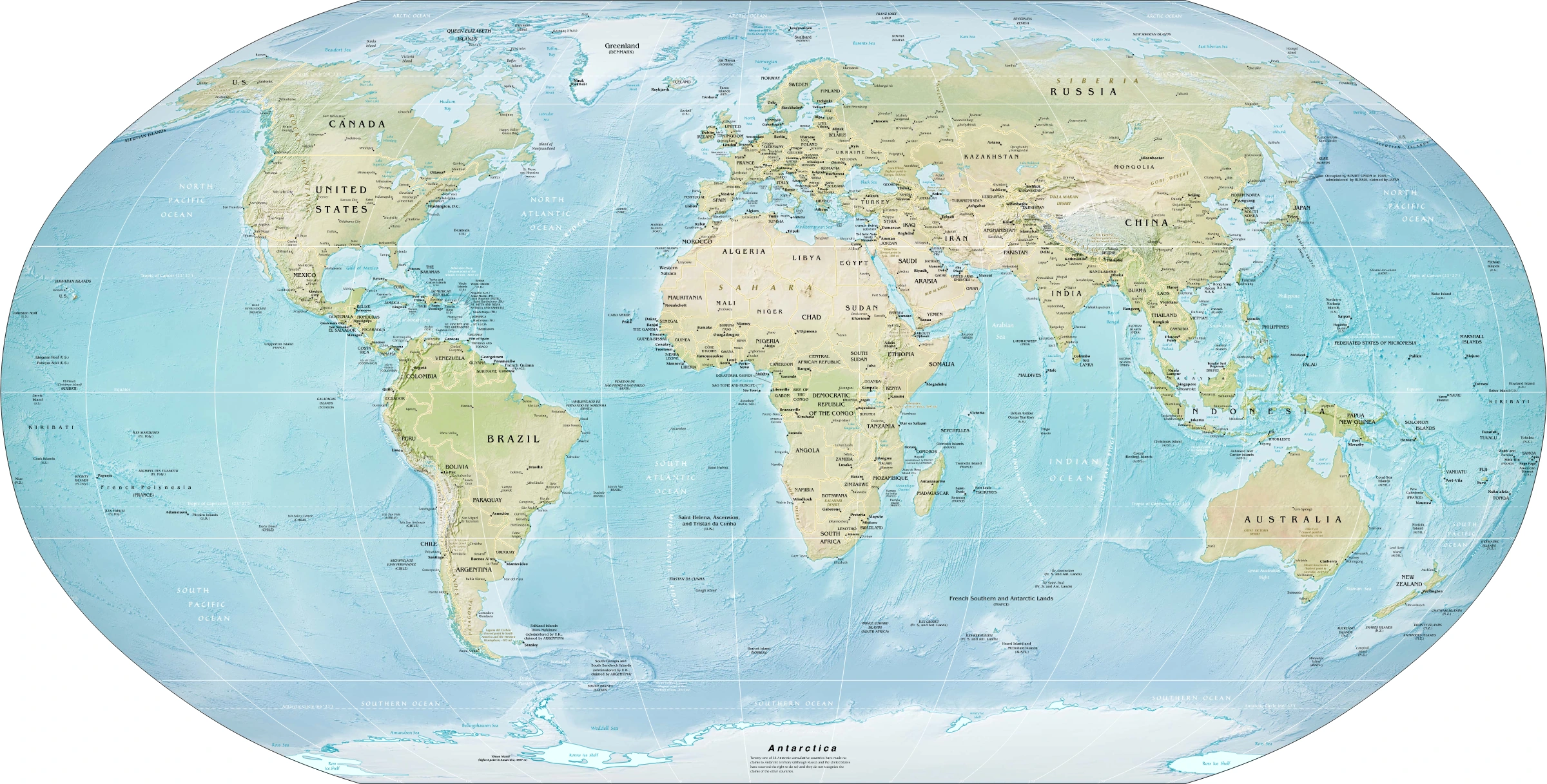
Map study
World physical relief: locate major mountain belts, plains and ocean basins. Regional orientation, not a detailed local landform survey.
- Read the source date and legend; distinguish territory, influence and geographic location.
- Historical boundaries and reference memberships are not live political or operational data.
Credit: US Government; Central Intelligence Agency · Public domain · sourceConverted to WebP on an opaque white background; proportionally resized without cropping. Original cartography and legend retained.
1. Understanding and mapping the ocean floor
Ocean-floor relief, or submarine topography, comprises the elevation differences and landforms beneath seawater. NCERT broadly groups the ocean floor into continental shelves, continental slopes, deep-sea plains and oceanic deeps. More detailed classifications distinguish continental rises, mid-ocean ridges, abyssal hills, submarine canyons, seamounts and guyots. These are not uniform belts present along every coastline: tectonic setting and sediment supply produce substantial regional differences.
Bathymetry is the measurement and mapping of underwater depth. Echo sounding calculates depth from the travel time of sound reflected from the seabed, with corrections for sound velocity in seawater. Multibeam sonar maps a wide swath rather than a single line. Satellite altimetry indirectly helps infer broad seabed relief through gravity-related variations in sea-surface height; it does not directly photograph the deep ocean floor.
Oceanic crust is typically about 5–10 km thick and predominantly basaltic, whereas continental crust is generally thicker and less dense. Most surviving oceanic crust is younger than about 200 million years because it is continuously created at spreading centres and recycled at subduction zones. Ocean basins therefore preserve a much younger geological record than ancient continental interiors.
- Bathymetric contours join points of equal water depth and are also called isobaths.
- Seabed depth alone does not identify crustal type: submerged continental crust can occur well below the shelf.
- Ocean-floor maps should be read together with maps of plate boundaries, earthquakes and volcanoes.
2. Continental margins: shelf, slope and rise
The continental shelf is the gently sloping submerged edge of a continent, extending from the coast to the shelf break. Its width varies from almost absent along some active margins to hundreds of kilometres along broad passive margins. Shelves developed through combinations of tectonic movement, erosion, sediment deposition and sea-level change. During Pleistocene glacial periods, lower sea levels exposed large shelf areas.
The continental slope descends more steeply from the shelf break towards the deep ocean basin. It commonly extends through depths of several thousand metres. The continental rise is a gently inclined sediment apron at the foot of the slope, formed largely by material transported downslope. A well-developed rise is characteristic of many passive margins but may be absent where a trench lies close to an active continental margin.
Active margins, such as much of the Pacific margin of South America, commonly have narrow shelves, steep slopes, trenches and nearby seismic or volcanic activity. Passive margins, such as much of the Atlantic coast, generally have broader sediment-covered shelves and rises. These are broad tendencies, not rigid rules.
Shelves matter economically because shallow, illuminated waters and nutrient supply often support productive fisheries. Sedimentary shelf basins also host petroleum and natural gas. Off India, the western shelf is notably broad near Gujarat, while shelf width varies considerably elsewhere. Mumbai High is an offshore petroleum field on the western continental shelf. The physical shelf must not be confused with the legal continental shelf under UNCLOS, which concerns sovereign rights over the seabed and subsoil rather than ownership of the overlying water.
- Submarine canyons are steep-sided valleys incised into shelves and slopes; some connect with major rivers, while others do not.
- Sediment-laden turbidity currents can erode canyons and deposit submarine fans beyond their mouths.
- Under UNCLOS, the legal continental shelf can extend to 200 nautical miles even where the geomorphological shelf is narrow; extension beyond this distance is subject to Article 76 criteria.
The oceanic lithosphere cycle
- 1. Plates diverge and mantle material rises beneath a spreading centre.
- 2. Decompression melting supplies magma that forms new oceanic crust.
- 3. The seafloor moves away, cools, thickens and generally subsides.
- 4. Sediments accumulate over the ageing oceanic crust.
- 5. At a convergent boundary, oceanic lithosphere may subduct into the mantle.
3. Deep ocean basins and minor relief features
Abyssal plains are exceptionally flat areas of the deep ocean floor, generally at depths of about 3,000–6,000 m. Their flatness results from sediments burying the irregularities of underlying oceanic crust. They are especially extensive where abundant sediment reaches the basin. Abyssal hills, by contrast, are low-relief elevations commonly associated with the formation and subsequent modification of oceanic crust.
Ocean trenches are elongated, narrow and very deep depressions, usually associated with one lithospheric plate descending beneath another. They differ from broad ocean basins in both shape and origin. The Mariana Trench lies in the western Pacific; the Peru–Chile Trench borders western South America. In the northeastern Indian Ocean, the Sunda or Java Trench forms part of the subduction system extending towards Sumatra and the Andaman region.
A seamount is a submarine mountain, usually volcanic and conventionally rising at least about 1,000 m above its surroundings. If it emerges above sea level, it forms an island. A guyot is a flat-topped seamount, commonly interpreted as a former volcanic island whose summit was eroded near sea level and later submerged through subsidence. Thus, neither seamounts nor guyots necessarily identify present-day plate boundaries.
Submarine fans form where sediment-carrying flows spread out and deposit material at the base of slopes or farther into basins. The Bengal Fan, supplied principally by the Ganga–Brahmaputra system, is the world's largest submarine fan. Oceanic plateaus are broad, elevated submarine regions, often associated with voluminous volcanism; the Kerguelen Plateau is a major Indian Ocean example.
- Abyssal plains are depositional surfaces; trenches are primarily tectonic depressions.
- A submarine canyon is an erosional valley and is not synonymous with an ocean trench.
- A guyot is flat-topped, whereas a typical seamount retains a more pointed or irregular summit.
| Feature | Typical form or setting | Dominant process | Prelims distinction |
|---|---|---|---|
| Continental shelf | Shallow, gently sloping continental margin | Submergence, erosion and sedimentation | Geomorphological shelf differs from the UNCLOS legal shelf |
| Continental rise | Sediment apron below the slope | Downslope sediment deposition | May be absent beside an active-margin trench |
| Abyssal plain | Very flat deep-basin surface | Sediment burial of irregular relief | Not the deepest ocean-floor feature |
| Mid-ocean ridge | Elevated divergent plate boundary | Upwelling, melting and crust formation | Not every submarine ridge is a spreading centre |
| Ocean trench | Narrow, elongated deep depression | Subduction | Not a submarine canyon |
| Guyot | Flat-topped submarine mountain | Volcanism, summit erosion and subsidence | A specialised type of seamount |
4. Plate tectonics, ridges and the Indian Ocean
Mid-ocean ridges form the interconnected submarine mountain system at divergent plate boundaries. As plates separate, mantle material rises and partially melts through decompression. Magma solidifies to create new oceanic crust. The hot, relatively buoyant lithosphere near the spreading axis stands higher than older, cooler seafloor farther away. Slow-spreading ridges commonly possess a pronounced axial rift valley, whereas fast-spreading ridges may have an axial high.
Several observations support seafloor spreading: basalt generally becomes older away from a spreading axis, sediment cover generally thickens with distance, and magnetic anomaly bands commonly show corresponding patterns on either side of the ridge. High heat flow and hydrothermal activity also characterise spreading centres. Transform faults offset ridge segments and accommodate lateral movement between plates.
The Mid-Atlantic Ridge illustrates a divergent boundary and rises above sea level in Iceland. In the Indian Ocean, the Central Indian, Southwest Indian and Southeast Indian ridges meet near the Rodrigues Triple Junction. The Carlsberg Ridge occupies the northwestern Indian Ocean. These active spreading structures should be distinguished from the Ninetyeast Ridge, a largely north–south volcanic ridge associated with hotspot activity rather than an active spreading boundary along its length.
The Lakshadweep–Chagos ridge system provides the volcanic foundation for many coral atolls. Corals construct reefs in suitable shallow, warm waters around subsiding volcanic foundations; they do not build directly upward from abyssal depths. The Andaman–Nicobar island arc, meanwhile, belongs to a convergent-margin setting associated with subduction, earthquakes and volcanism.
- Divergence creates new oceanic crust; subduction consumes oceanic lithosphere.
- Not every submarine ridge is a mid-ocean spreading ridge.
- Earthquake depth is a useful clue: divergent boundaries mainly produce shallow earthquakes, while subduction zones can generate shallow, intermediate and deep earthquakes.
5. Sediments, resources and environmental significance
Marine sediments are classified by origin. Terrigenous or lithogenous material comes from weathering and erosion of rocks on land. Biogenous sediment consists largely of organism remains, including calcareous shells and siliceous tests. Hydrogenous material precipitates from seawater, while cosmogenous material arrives from space. Their distribution reflects distance from land, biological productivity, currents, water chemistry and depth.
Calcareous remains tend to dissolve below the carbonate compensation depth, where their supply is balanced by dissolution. Its depth varies among ocean basins and through time; it is not a fixed global line. Siliceous oozes accumulate particularly where silica-producing organisms are abundant. Turbidites record episodic sediment-gravity flows rather than only slow settling through the water column.
Seabed resources include shelf hydrocarbons, polymetallic nodules on some abyssal plains, cobalt-rich crusts on seamounts and polymetallic sulphides around hydrothermal systems. India holds an International Seabed Authority exploration contract for polymetallic nodules in the Central Indian Ocean Basin. Exploration is not equivalent to commercial extraction. Deep-sea mining raises concerns about habitat removal, sediment plumes, noise and the slow recovery of poorly understood ecosystems.
Ocean-floor knowledge also supports tsunami assessment, submarine cable routing and navigation. Large tsunamis commonly result from rapid vertical seabed displacement during major submarine earthquakes, especially at subduction zones. Hydrothermal vents sustain chemosynthesis-based communities, demonstrating that deep-ocean ecosystems need not depend directly on sunlight.
- The International Seabed Authority regulates mineral-related activities in the Area, the seabed beyond national jurisdiction.
- India's Deep Ocean Mission, approved in 2021, supports deep-sea technologies, exploration and ocean science.
- For map revision, prioritise the Mariana and Sunda trenches, Mid-Atlantic Ridge, Indian Ocean ridge junctions, Ninetyeast Ridge and Bengal Fan.
Real-world case studies
Bengal Fan: mountains recorded beneath the ocean
Erosion of the Himalayas supplies enormous quantities of sediment to the Ganga–Brahmaputra system. Sediment transported into the Bay of Bengal is redistributed through submarine channels and gravity flows, building the Bengal Fan. Its deposits preserve evidence of Himalayan erosion, monsoon variability and sediment transport, connecting continental processes with deep-ocean landforms.
The 2004 Indian Ocean tsunami
On 26 December 2004, a magnitude 9.1 earthquake occurred off northern Sumatra along the Sunda subduction system. Rapid seabed displacement generated a tsunami that devastated coastlines across the Indian Ocean, including India. The event illustrates why understanding trenches, megathrust faults and bathymetry is essential for coastal hazard assessment.
Previous year questions
UPSC Mains 2022 · GS-I
Describe the characteristics and types of primary rocks.
- Primary rocks are igneous rocks formed by cooling and solidification of magma or lava.
- Distinguish intrusive and extrusive rocks using cooling rate, texture and examples.
- For the ocean-floor connection, explain basaltic crust formation at spreading centres.
Practice questions
Practice MCQ 1
Consider the following statements: 1. Abyssal plains commonly acquire their flatness through sediment deposition. 2. A continental rise is necessarily present between every continental slope and ocean basin. 3. Guyots are flat-topped submarine mountains. Which of the statements given above are correct?
- A. 1 and 2 only
- B. 1 and 3 only
- C. 2 and 3 only
- D. 1, 2 and 3
Practice MCQ 2
Which one of the following pairs is incorrectly matched?
- A. Mariana Trench — Subduction-related depression
- B. Bengal Fan — Major submarine sediment accumulation
- C. Ninetyeast Ridge — Active divergent boundary along its entire length
- D. Mid-Atlantic Ridge — Formation of new oceanic crust
Practice MCQ 3
In a typical ocean basin, which combination most strongly supports seafloor spreading?
- A. Increasing crustal age away from the ridge and corresponding magnetic bands on either side
- B. Oldest crust at the ridge axis and progressively younger crust towards continental margins
- C. Uniform crustal age and absence of heat flow at the ridge
- D. Deep-focus earthquakes concentrated directly beneath all spreading axes
Mains practice · Explain how plate tectonics and sedimentary processes together shape ocean-floor relief. Illustrate your answer with examples from the Indian Ocean. (250 words)
- Introduce continental margins, deep basins and submarine tectonic features.
- Explain ridge formation through divergence and trench formation through subduction.
- Distinguish active spreading ridges from hotspot-related ridges.
- Discuss continental rises, abyssal plains, canyons and submarine fans.
- Use the Central Indian Ridge, Sunda Trench, Ninetyeast Ridge and Bengal Fan.
- Conclude with implications for resources, ecosystems and tsunami hazards; add a labelled cross-section.
Further reading
- NCERT, Fundamentals of Physical Geography, Class XI: Distribution of Oceans and Continents; Water (Oceans).
- NOAA Ocean Exploration: resources on seafloor mapping, ocean trenches and hydrothermal vents.
- GEBCO: global bathymetric charts and seabed mapping resources.
- United Nations Convention on the Law of the Sea: Article 76 and Part XI.
- International Seabed Authority: India's polymetallic nodule exploration contract and marine environmental resources.
- Ministry of Earth Sciences, Government of India: Deep Ocean Mission.
Preparing for UPSC Civil Services? Get classroom teaching, answer-writing evaluation and mentorship at Pragnya IAS Academy, Ashok Nagar — see why aspirants choose us for IAS coaching in Hyderabad.