
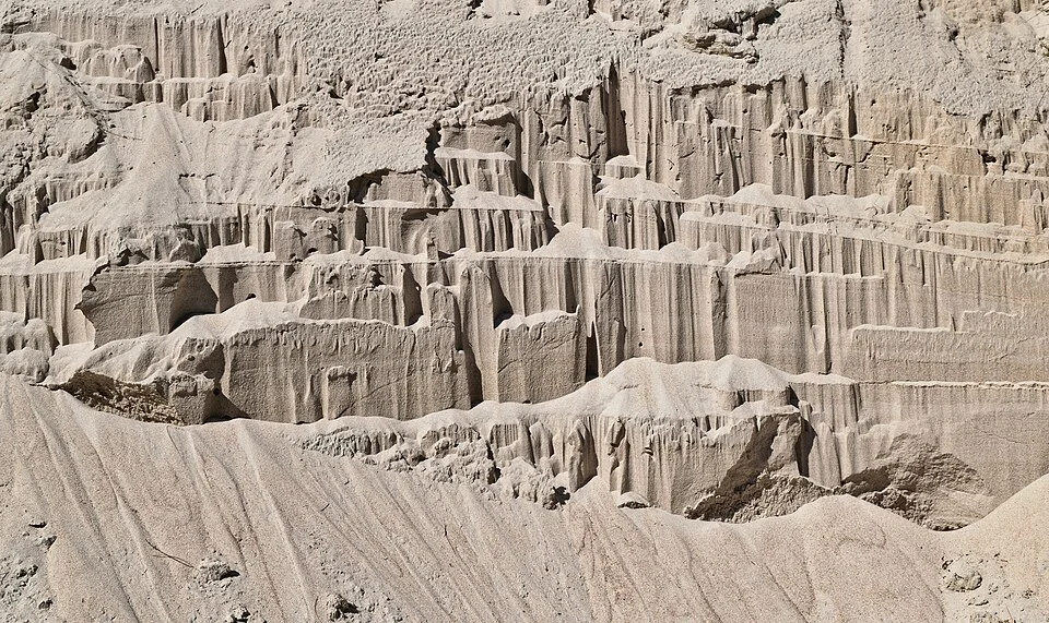
Bank erosion structures in sand at Harris River; a comparative illustration of river erosion.
Credit: СССР · CC BY-SA 2.5 ca · sourceResized and converted to WebP; uncropped.
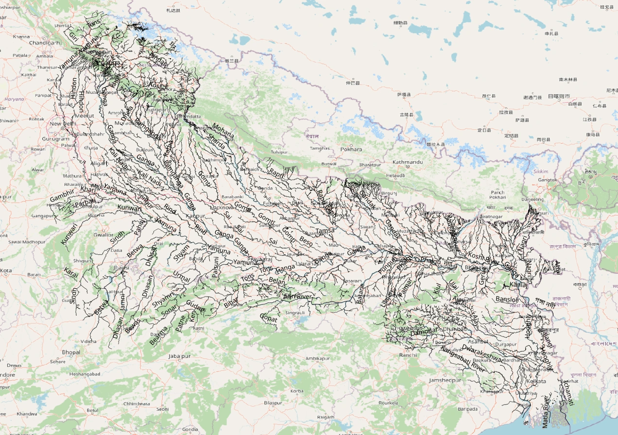
Map study
Ganga–Yamuna basin: trace Himalayan tributaries and trunk drainage. Catchment boundaries are not political borders.
- Read the source legend, scale and reference period before comparing regions.
- Connect spatial patterns to the processes discussed in this topic; this map is a study reference, not live operational data.
Credit: Heinz OSM · ODbL · sourceConverted to WebP on an opaque white background; proportionally resized without cropping. Original cartography and legend retained.
1. Meaning, controls and directions of river erosion
River or fluvial erosion is one component of running-water activity, alongside sediment transportation and deposition. Weathering weakens rock in place, while erosion removes material from the bed, banks and valley sides. Gravity supplies the potential energy that flowing water converts into motion. Some energy is dissipated through turbulence and friction; some entrains sediment and wears down channel boundaries. Consequently, a river’s erosive effect cannot be inferred from its length or water volume alone.
The principal controls are discharge, channel gradient, flow velocity and depth, sediment characteristics, vegetation and geological resistance. Discharge is the volume passing a cross-section per unit time, commonly measured in cubic metres per second. Stream power increases with discharge and slope, but actual erosion also depends on the availability of loose sediment and the resistance of the bed. Jointed rock, unconsolidated alluvium and poorly vegetated banks are generally more vulnerable than massive, resistant rock.
Vertical erosion, or downcutting, lowers the bed; lateral erosion removes banks and promotes valley widening; headward erosion extends channels towards their source. These operate together, although their relative importance varies. Steep upland channels commonly show strong incision, while low-gradient alluvial channels often migrate laterally. However, downstream discharge may compensate for a gentler gradient, and floods can cause major erosion even on broad plains.
- Bedrock channels erode their underlying rock; alluvial channels adjust within sediment previously deposited by rivers.
- Erosion is episodic: a few high-flow events may account for much of a river’s long-term channel change.
2. Mechanisms of erosion and sediment movement
Hydraulic action is the mechanical force of flowing water against channel boundaries. Turbulent flow can dislodge loose particles and exploit joints or bedding planes. Plucking removes blocks from fractured bedrock when hydraulic forces overcome their resistance. River erosion therefore often depends on prior weathering and rock structure: a fractured outcrop can be excavated more rapidly than an equally hard but unjointed one.
Abrasion, also called corrasion, occurs when transported sand, gravel and larger fragments scrape, strike or grind the bed and banks. Sediment acts as an erosive tool, but its effect is not unlimited. A thick sediment cover can shield bedrock from further abrasion. Attrition is different: transported fragments collide, becoming smaller and generally more rounded. Solution, sometimes called corrosion, chemically removes soluble minerals; it is especially significant in limestone and other soluble-rock terrains.
Entrainment begins when fluid forces exceed the resistance of particles. Clay can resist initial erosion because its particles are cohesive, even though clay particles remain suspended easily once entrained. The Hjulström diagram expresses the broad relationship between grain size and the velocities associated with erosion, transport and deposition. Sand is generally easier to entrain than cohesive clay or coarse gravel. The diagram is conceptual rather than a universal velocity rule for every river.
- Traction moves coarse particles along the bed; saltation moves grains in short hops.
- Suspension carries fine sediment within the water column; solution transports dissolved substances.
- Do not equate faster transport with greater bedrock erosion: sediment availability and protective bed cover also matter.
A common pathway of waterfall retreat
- 1. A resistant layer overlies or adjoins more easily eroded rock
- 2. Turbulence and abrasion excavate the weaker rock and plunge pool
- 3. Undercutting leaves resistant rock unsupported
- 4. Unsupported blocks collapse and are broken down or transported
- 5. Repeated erosion shifts the waterfall upstream
- 6. A gorge may remain downstream
3. Erosional landforms and their identification
V-shaped valleys develop where channel incision combines with weathering and downslope movement of material from valley sides. Interlocking spurs may remain as an upland river winds around resistant projections rather than cutting directly through them. A gorge is a deep, narrow valley with steep sides; canyon commonly describes a particularly large, deep valley, often with stepped slopes reflecting alternating rock layers. These terms overlap and should not be treated as rigid climatic categories.
Waterfalls and rapids occur at abrupt changes in channel gradient. Differential erosion between resistant and weaker rocks is a common cause, but faulting, glacial hanging valleys and other geological conditions can also produce waterfalls. Turbulence and sediment impact excavate a plunge pool. Undercutting may destabilise overlying rock, causing collapse and upstream retreat of the fall. Continued retreat can leave a gorge downstream.
Potholes are rounded bedrock depressions enlarged by turbulent eddies and sediment abrasion. Meanders demonstrate the coexistence of erosion and deposition: the outer bank commonly forms an eroding cut bank or river cliff, while the inner bank supports a depositional point bar. Flow circulation through bends helps redistribute sediment. Neck or chute cutoffs can shorten the channel and leave abandoned bends, some of which become oxbow lakes. Oxbow formation is therefore not solely an erosional process.
- A gorge alone does not prove river youth; uplift, structural controls or long-term incision may explain it.
- Meanders can occur in both alluvial plains and deeply incised bedrock valleys.
| Process | Main action | Exam distinction |
|---|---|---|
| Hydraulic action | Water forces detach material | Does not require sediment to act as an abrasive tool |
| Abrasion | Sediment scrapes and impacts channel boundaries | Also called corrasion |
| Attrition | Transported particles collide and fragment | Primarily modifies the load rather than the bed |
| Solution | Minerals dissolve in water | Chemical rather than mechanical removal |
| Headward erosion | Channel heads retreat upstream | A direction of erosion, not a separate physical mechanism |
4. Base level, rejuvenation and drainage adjustment
Base level is the limiting level towards which a river can erode its bed. Sea level is the ultimate base level for rivers draining to the ocean, while lakes, resistant rock barriers and reservoirs create local controls. A river’s longitudinal profile commonly becomes gentler downstream. A graded river maintains an approximate balance among water discharge, sediment supply, channel form and slope; it is dynamically adjusting, not inactive or permanently fixed.
Rejuvenation means renewed erosive activity after a change in controlling conditions. Relative land uplift or a fall in base level may increase the potential for incision. A knickpoint is a local break in the longitudinal profile, expressed as a steep reach or waterfall; some migrate upstream as erosion proceeds. Climatic changes affecting discharge and sediment supply can also trigger channel adjustment. Not every knickpoint marks tectonic uplift, because resistant rock and human structures may produce similar forms.
River terraces are remnants of former floodplain or valley-floor surfaces left above an incising channel. They record alternating phases of deposition, stability and erosion, rather than uplift alone. Incised meanders may preserve bends developed before renewed downcutting. Headward erosion can also contribute to river capture, in which one stream diverts another’s headwaters. An elbow of capture, wind gap or underfit stream may support this interpretation, but reconstruction requires several lines of evidence.
- The Davisian cycle is a useful historical model, not a universal timetable for river-landscape evolution.
- Tectonics, climate, rock structure and inherited drainage frequently interrupt idealised evolutionary sequences.
5. Indian relevance, hazards and human interventions
Himalayan rivers combine active tectonics, steep tributaries, monsoonal flows and large sediment inputs. On the Assam plains, the Brahmaputra’s mobile braided channels repeatedly erode banks and redistribute bars. Bank retreat results from both removal of material at the bank toe and collapse of unstable upper banks. Flood inundation and bank erosion are related but distinct hazards: water may recede after a flood, whereas eroded agricultural land or settlements may be permanently lost.
Peninsular rivers also provide major erosional examples. The Narmada gorge near Bhedaghat illustrates incision through a geologically controlled landscape, while the Chambal basin’s ravines show extensive gully erosion and headward extension through erodible material. Gully erosion connects hillslope runoff with channel networks, but it should not be confused with the continuous bank erosion of a large perennial river.
Dams trap sediment and modify flow regimes. Sediment-starved releases may erode downstream beds and banks, although reduced flood peaks can suppress other erosive processes. Excessive in-channel sand extraction may lower the bed, destabilise banks and expose bridge foundations. Management should combine catchment treatment, riparian vegetation, monitoring, floodplain zoning and context-specific bank protection. Embankments or revetments can protect selected sites but may transfer erosion elsewhere; channel-scale assessment is essential.
- Useful observations include repeated cross-sections, bankline mapping, sediment measurements and satellite imagery.
- For Prelims, distinguish erosion from deposition even when both processes contribute to a single landform.
Bank Erosion: Flow, Sediment and Slope Failure
The supplied metadata identifies bank erosion structures in sand at Harris River and gives an approximate horizontal field of view of three metres. This makes the image directly relevant to river erosion at the channel-bank scale. Flow can detach and entrain bank material when applied shear stress exceeds its resistance. Removal near the bank toe may also destabilise overlying sediment, causing collapse under gravity. Bank retreat therefore combines fluvial erosion with mass movement; it is not necessarily the result of abrasion alone.
This is a comparative example, not evidence from an Indian river. The same process framework helps explain bank retreat along Indian alluvial rivers, including the Ganga and Brahmaputra, where channel migration can affect settlements, farmland and infrastructure. However, the metadata does not establish flow conditions, erosion rates, sediment cohesion or the precise mechanism responsible here. Sandy banks are generally less cohesive than clay-rich banks, but moisture, layering and vegetation modify their stability. For Mains, connect bank erosion to floodplain management: protective works may reduce erosion locally while changing flow and sediment transport elsewhere.
- Distinguish lateral erosion, which widens or shifts channels, from vertical erosion, which deepens the river bed; both can operate within one reach.
- Outer meander banks commonly erode while inner banks accumulate sediment, but local geology and engineering can modify this pattern.
- Deposition elsewhere does not negate erosion: rivers redistribute sediment, and bank failure may occur during falling water levels as support declines.
Real-world case studies
Brahmaputra bank erosion around Majuli, Assam
Majuli’s river-island landscape is shaped by erosion, deposition and shifting Brahmaputra channels. Loss of land threatens villages, agriculture and cultural institutions such as satras. Its area varies with the observation period and mapping method, making undated area figures misleading. The case highlights the need to assess both local bank stability and the wider braided-channel system.
Chambal ravines
Ravines along the Chambal and its tributaries in Madhya Pradesh, Rajasthan and Uttar Pradesh reflect concentrated runoff, gully incision, headward erosion and bank collapse in susceptible materials. They illustrate how erosion expands drainage networks and degrades land. Treatment requires management of runoff and vegetation across the catchment, not merely barriers within individual gullies.
Previous year questions
No source-linked PYQ is available here yet. Use the practice questions below.
Practice questions
Practice MCQ 1
With reference to river erosion, consider the following statements: 1. Abrasion involves the wearing away of channel boundaries by transported sediment. 2. Attrition primarily refers to chemical dissolution of the river bed. 3. Headward erosion can contribute to river capture. Which of the statements given above are correct?
- A. 1 and 2 only
- B. 1 and 3 only
- C. 2 and 3 only
- D. 1, 2 and 3
Practice MCQ 2
Why may cohesive clay require a higher flow velocity for initial erosion than fine sand?
- A. Clay particles are always denser than sand particles
- B. Clay cannot be transported in suspension
- C. Cohesive forces bind clay particles together
- D. Fine sand is transported only in solution
Practice MCQ 3
Consider the following statements: 1. River terraces may represent remnants of former valley floors. 2. Every river knickpoint proves recent tectonic uplift. 3. Sediment trapped by a dam can influence downstream erosion. Which of the statements given above are correct?
- A. 1 only
- B. 2 and 3 only
- C. 1 and 3 only
- D. 1, 2 and 3
Mains practice · Explain the principal processes of river erosion. How do changes in base level and human interventions modify erosional landforms and channel stability? Illustrate with Indian examples. Answer in 250 words.
- Distinguish hydraulic action, abrasion and solution from attrition of the transported load.
- Explain vertical, lateral and headward erosion with suitable landforms.
- Connect base-level changes with incision, knickpoint migration, terraces and incised meanders.
- Discuss dams, sediment trapping, sand extraction and bank-protection structures with qualified impacts.
- Use Brahmaputra bank erosion, Chambal ravines or the Narmada gorge as examples.
- Conclude with catchment-to-channel management and the need to separate flood inundation from erosion risk.
Further reading
- NCERT, Class XI, Fundamentals of Physical Geography: Geomorphic Processes; Landforms and their Evolution.
- NCERT, Class XI, India: Physical Environment: Drainage System.
- Central Water Commission, official resources on flood management and river morphology: cwc.gov.in.
- Brahmaputra Board, official publications and information on flood and erosion management: brahmaputraboard.gov.in.
- G. C. Leong, Certificate Physical and Human Geography: Landforms Made by Running Water.
- https://commons.wikimedia.org/wiki/File:Bank_erosion_structures_in_sand,_Harris_River.jpg
Preparing for UPSC Civil Services? Get classroom teaching, answer-writing evaluation and mentorship at Pragnya IAS Academy, Ashok Nagar — see why aspirants choose us for IAS coaching in Hyderabad.