

Mississippi River Delta Aerial
Credit: formulanone from Huntsville, United States · CC BY-SA 2.0 · source
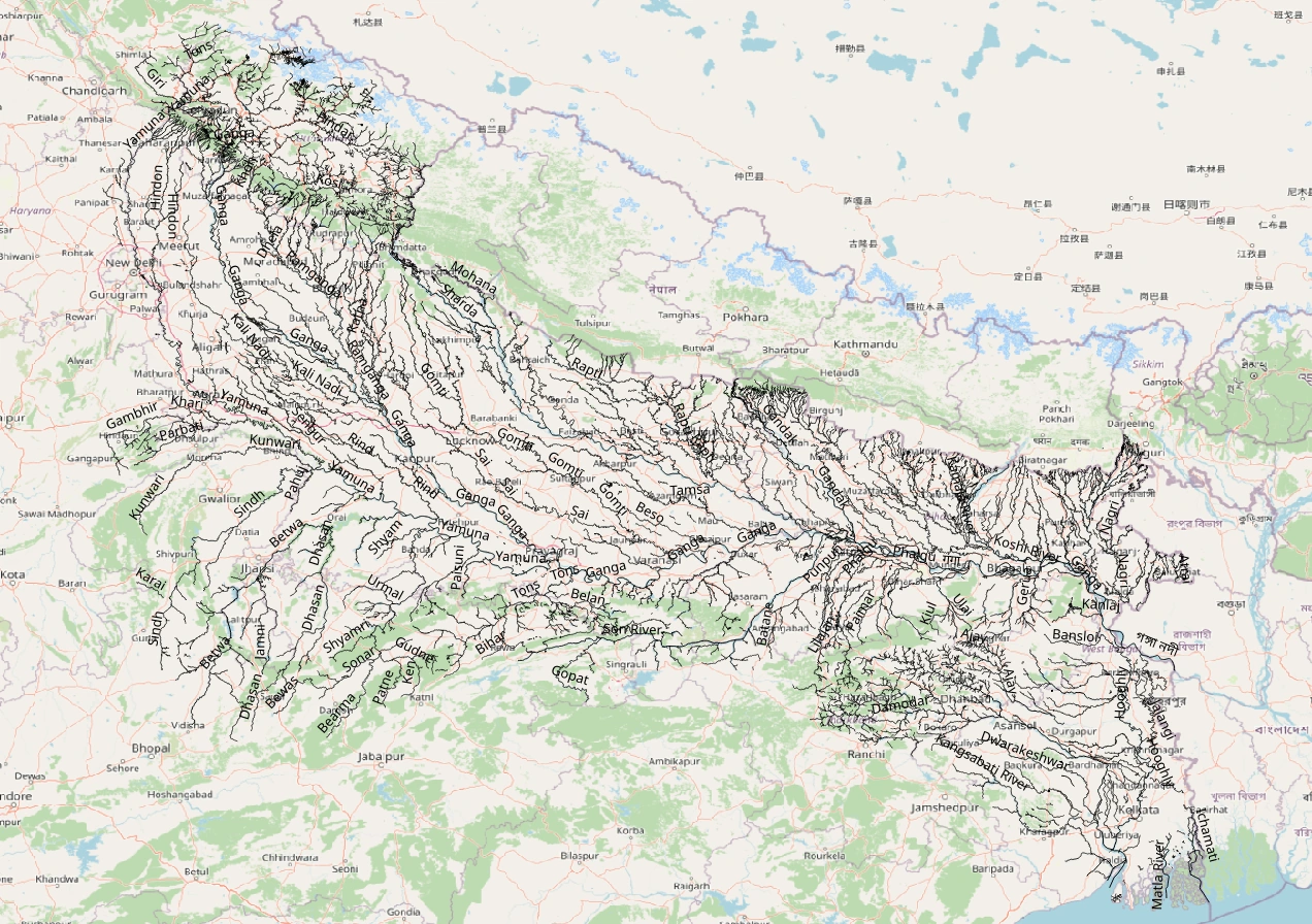
Map study
Ganga–Yamuna basin: trace Himalayan tributaries and trunk drainage. Catchment boundaries are not political borders.
- Read the source legend, scale and reference period before comparing regions.
- Connect spatial patterns to the processes discussed in this topic; this map is a study reference, not live operational data.
Credit: Heinz OSM · ODbL · sourceConverted to WebP on an opaque white background; proportionally resized without cropping. Original cartography and legend retained.
1. Why rivers deposit sediment
River deposition occurs when sediment supply exceeds the transporting ability of a stream. A river carries coarse particles as bed load through rolling, sliding and saltation, while finer particles travel in suspension. Dissolved substances move as solute load and generally do not settle mechanically like sand or silt. Their deposition requires chemical precipitation or biological processes. Sediment availability matters: a powerful river with little sediment supply may deposit less than a weaker, heavily loaded stream.
Transport depends on discharge, velocity, turbulence, slope and boundary shear stress. A decline in flow strength can reduce competence, causing larger particles to stop moving, and capacity, causing part of the sediment load to accumulate. Deposition commonly accompanies falling flood discharge, entry into standing water, flow spreading beyond a channel or a reduction in channel gradient. However, gradient alone does not determine deposition because discharge and channel geometry can change simultaneously.
The Hjulström diagram relates particle size and flow velocity to erosion, transport and deposition. Sand is relatively easy to entrain, whereas cohesive clay can require stronger currents for initial erosion. Once suspended, very fine particles may remain mobile at low velocities. Consequently, the conditions needed to erode a particle are not identical to those needed to keep it moving.
- Aggradation means a net rise in river-bed or valley-floor elevation through sediment accumulation.
- Deposition is not confined to a river’s lower course: it also occurs behind obstacles, in mountain valleys and along inner bends.
2. Channel deposits, meanders and floodplains
Within channels, local variations in velocity and sediment transport produce bars. A point bar accumulates on the inner side of a meander bend, where near-bank flow is generally weaker. The outer bank commonly experiences greater erosion and develops a cut bank or river cliff. Helical circulation helps redistribute water and sediment across the bend. As bends migrate, point-bar deposits build lateral-accretion surfaces, sometimes marked by meander scrolls.
Mid-channel bars occur where sediment accumulates within the active channel. Braided rivers contain multiple shifting channels separated by bars or islands. They are commonly associated with abundant sediment, variable discharge and readily erodible banks. Braiding and deltaic distributaries are not equivalent: braided channels repeatedly divide and rejoin within a river reach, whereas distributaries branch across a delta towards its receiving water body.
A floodplain develops through both lateral channel migration and vertical accumulation during overbank floods. When floodwater leaves the main channel, it spreads across a rougher surface and loses transporting power. Repeated deposition creates layers of alluvium. Meander cutoffs may leave oxbow lakes, which gradually fill with fine sediment and organic material. An oxbow lake therefore results from channel cutoff and abandonment, not deposition alone.
- A floodplain is an active river-associated landform, not simply any flat plain near a river.
- River terraces are abandoned former floodplain or valley-floor surfaces left above the active channel, commonly following incision.
Formation of natural levees and backswamps
- 1. Flood discharge exceeds channel capacity
- 2. Water spreads across the floodplain
- 3. Transporting power decreases outside the channel
- 4. Relatively coarse sediment settles near the banks
- 5. Finer sediment reaches more distant flood basins
- 6. Repeated floods build levees beside low-lying backswamps
3. Natural levees, backswamps and Indian alluvial plains
Natural levees are low ridges of alluvium bordering river channels. During an overbank flood, the abrupt reduction in flow velocity causes much of the relatively coarse suspended material to settle close to the bank. Finer silt and clay travel farther into the flood basin. Repeated floods gradually build levees, although their continuity and height vary. Natural levees must be distinguished from artificial embankments constructed for flood protection.
Beyond levees, poorly drained depressions called backswamps may develop. Fine-grained sediment restricts infiltration, while levees obstruct drainage back into the channel. A levee breach can create a crevasse splay: a fan-like deposit spreading across the floodplain. Where sustained aggradation raises the channel relative to adjacent land, floods may trigger avulsion, an abrupt diversion into a new course.
In the northern Indian plains, khadar refers to relatively younger floodplain alluvium, generally renewed by river flooding. Bhangar is older alluvium, often occupying higher surfaces beyond ordinary annual floods and sometimes containing calcareous kankar nodules. Along the Himalayan foothills, the Bhabar belt contains coarse, porous deposits into which streams may disappear. Farther south, groundwater re-emergence and finer deposits contribute to the wetter Terai belt.
- Khadar and bhangar are regional alluvial categories, not universal labels for every depositional surface.
- Floodplain fertility reflects mineral renewal and moisture availability, but flooding, waterlogging and sand burial can damage agriculture.
| Feature | Typical setting | Diagnostic characteristic |
|---|---|---|
| Point bar | Inner meander bend | Lateral accumulation accompanying bend migration |
| Natural levee | Beside a flood-prone channel | Relatively coarse overbank deposits near the bank |
| Backswamp | Flood basin behind levees | Fine sediment and poor drainage |
| Alluvial fan | Valley exit or mountain front | Fan-shaped deposit spreading from an apex |
| Delta | River mouth in a lake or sea | Sediment accumulation commonly crossed by distributaries |
4. Alluvial fans and deltas
An alluvial fan forms where sediment-laden flow emerges from a confined valley and spreads across an open surface, commonly at a mountain front. Reduced confinement and often a lower gradient encourage deposition. Fans typically have coarse proximal deposits near the apex and finer material towards their margins, though floods and debris flows produce considerable variation. Adjacent fans may merge into a bajada, especially along arid mountain fronts. Fans also occur in humid environments.
A delta develops where a river enters a sea or lake and delivers sediment that accumulates at its mouth. Delta growth reflects the balance among sediment input, waves, tides, currents, subsidence and relative water-level change. A river mouth does not automatically develop a delta. Strong marine redistribution, deep receiving waters or insufficient sediment supply may prevent substantial accumulation.
River-dominated deltas may develop elongated distributary lobes, exemplified by the Mississippi bird’s-foot pattern. Wave-dominated deltas tend to have smoother shorelines, while tide-dominated deltas exhibit prominent tidal channels and elongated sediment bodies. The Ganga–Brahmaputra–Meghna delta combines enormous fluvial sediment input with strong tidal influence. The Mahanadi, Godavari, Krishna and Kaveri have major east-coast deltas; the Narmada and Tapi instead have prominent estuarine mouths.
- Marine deltas can experience flocculation, in which fine particles aggregate after freshwater mixes with saline water.
- An estuary is not necessarily sediment-free: estuaries can contain extensive mudflats, sandbanks and other deposits.
5. Sediment budgets, hazards and management
Depositional landscapes change when sediment inputs, storage or outputs change. Catchment erosion, landslides and land-use disturbance can increase sediment delivery, while dams intercept sediment and reduce downstream supply. Reservoir sedimentation occupies storage space and can impair infrastructure. Downstream effects depend on local conditions, but sediment-starved releases may promote channel-bed erosion and reduce material available to floodplains and deltas.
Deposition creates fertile land, wetlands and groundwater-bearing alluvial aquifers, but also raises flood risk where channel capacity declines. Sandbars can obstruct navigation, and avulsion can shift hazards towards previously less exposed settlements. Excessive sand mining disrupts sediment continuity and can encourage incision, bank instability and damage near bridges. Conversely, blanket dredging is not a permanent solution because rivers may refill excavated reaches.
Management should assess the entire sediment budget rather than treating every deposit as waste. Floodplain zoning, protection of wetlands, catchment treatment and monitoring of channel migration reduce exposure and improve planning. Reservoir flushing or sediment bypass may help where technically and environmentally suitable. The National Water Policy, 2012 supports floodplain zoning and a basin-oriented approach to water management; depositional processes are central to applying these principles.
Real-world case studies
Kosi avulsion, Bihar, 2008
In August 2008, the Kosi breached its eastern embankment near Kusaha in Nepal and diverted into an older course, causing widespread flooding in Bihar. The event illustrates the interaction of a sediment-rich, aggrading river system with embankment vulnerability. It was not simply a case of exceptionally high discharge.
Nile delta after the Aswan High Dam
The Aswan High Dam traps much of the Nile’s sediment in Lake Nasser. Reduced sediment delivery has contributed to erosion along parts of the delta coast, alongside subsidence, sea-level rise and coastal interventions. The case demonstrates that upstream sediment retention can affect landforms far downstream.
Previous year questions
No source-linked PYQ is available here yet. Use the practice questions below.
Practice questions
Practice MCQ 1
Consider the following statements: 1. River competence refers to the largest particle size that can be transported. 2. Dissolved load normally settles when river velocity decreases. 3. Clay already in suspension can remain mobile at very low velocities. Which statements are correct?
- A. 1 and 2 only
- B. 1 and 3 only
- C. 2 and 3 only
- D. 1, 2 and 3
Practice MCQ 2
Which sequence best represents a common depositional pattern moving away from a river channel across its floodplain?
- A. Backswamp followed by natural levee
- B. Natural levee followed by fine-grained backswamp
- C. Alluvial fan followed by river cliff
- D. Delta followed by point bar
Practice MCQ 3
Consider the following statements: 1. Alluvial fans occur only in deserts. 2. Delta growth depends partly on the balance between sediment supply and marine redistribution. 3. Braided channels and deltaic distributaries are geomorphologically identical. Which statements are correct?
- A. 1 only
- B. 2 only
- C. 2 and 3 only
- D. 1, 2 and 3
Mains practice · Explain the formation of major river depositional landforms. How do human interventions alter sediment movement and associated hazards? Answer in 250 words.
- Introduce deposition through sediment supply, competence and capacity.
- Explain point bars, floodplains, levees, fans and deltas with locations.
- Discuss dams, embankments, catchment disturbance and sand mining.
- Use the Kosi avulsion and Nile delta as examples.
- Conclude with sediment-budget assessment, floodplain zoning and basin-scale management.
Further reading
- NCERT, Class XI, Fundamentals of Physical Geography: Geomorphic Processes; Landforms and their Evolution.
- NCERT, Class XI, India: Physical Environment: Structure and Physiography; Drainage System.
- Ministry of Water Resources, National Water Policy, 2012.
- Central Water Commission: publications on reservoir sedimentation and flood management.
- US Geological Survey: Water Science School resources on rivers, sediment and erosion.
Preparing for UPSC Civil Services? Get classroom teaching, answer-writing evaluation and mentorship at Pragnya IAS Academy, Ashok Nagar — see why aspirants choose us for IAS coaching in Hyderabad.