

Thingvellir National Park rift valley
Credit: Pi3.124 · CC BY-SA 3.0 · source
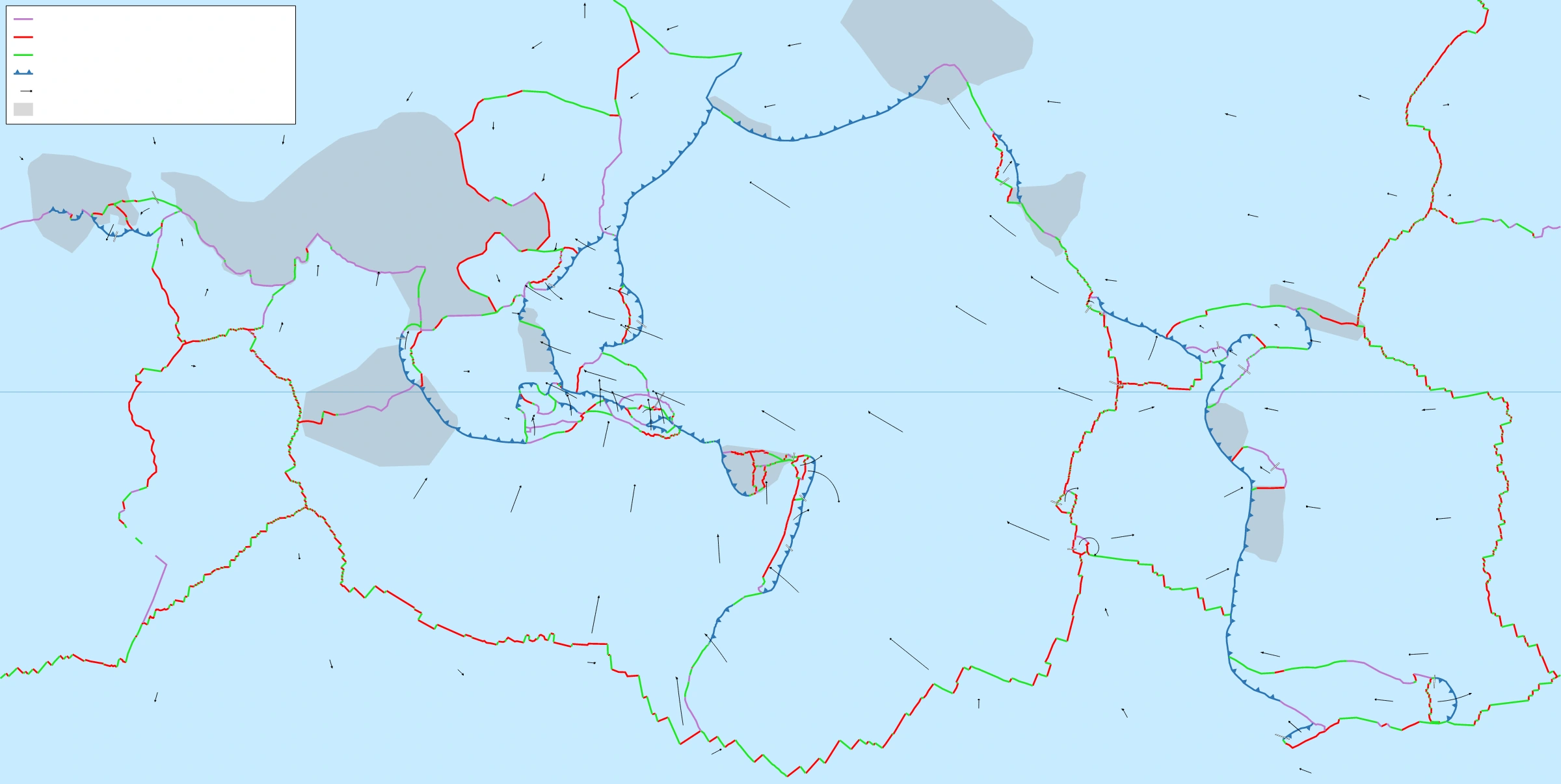
Map study
World tectonic plates: locate the Indian and Eurasian plates and distinguish convergent, divergent and transform boundaries through the legend.
- Read the source legend, scale and reference period before comparing regions.
- Connect spatial patterns to the processes discussed in this topic; this map is a study reference, not live operational data.
Credit: Eric Gaba (Sting) · CC BY-SA 2.5 · sourceConverted to WebP on an opaque white background; proportionally resized without cropping. Original cartography and legend retained.
1. Concept and place in geomorphology
Sea-floor spreading explains how ocean floors are created, displaced and eventually recycled. At a mid-ocean ridge, neighbouring lithospheric plates move apart. Hot mantle material rises beneath the opening, partially melts, and supplies magma that cools into new oceanic crust. Repeated additions separate previously formed crust from the ridge axis. The ocean floor therefore behaves as part of a moving lithospheric plate rather than as a permanent, stationary basin.
Alfred Wegener’s continental drift hypothesis, presented in 1912, drew support from matching continental margins, fossils, rocks and palaeoclimatic indicators. However, it lacked a satisfactory driving mechanism. Post-war sonar mapping revealed a nearly continuous global mid-ocean ridge system, while oceanographic surveys identified deep trenches, magnetic anomalies and unexpectedly young ocean floors. Hess and Dietz brought these discoveries together into an explanation of ocean-basin renewal.
Sea-floor spreading is narrower than plate tectonics. The former describes crustal creation and separation at spreading centres; the latter explains the movement and interaction of entire lithospheric plates at divergent, convergent and transform boundaries. Continents do not independently plough through oceanic crust: both continental and oceanic regions can belong to the same moving plate.
- Crust is a compositional layer; lithosphere is the mechanically rigid crust plus uppermost mantle.
- The asthenosphere beneath the lithosphere is predominantly solid but can deform and flow over geological time.
Timeline
1912
Alfred Wegener presents continental drift.
1961
Robert Dietz publishes an account using the term sea-floor spreading.
1962
Harry Hess publishes History of Ocean Basins.
1963
Vine and Matthews publish the magnetic-reversal explanation of marine magnetic anomalies; Morley develops it independently.
1968 onwards
Deep Sea Drilling Project investigations provide systematic ocean-floor age and sediment evidence supporting spreading.
2. Mechanism and associated landforms
As plates diverge, underlying mantle rises and experiences reduced pressure. This produces decompression melting, rather than melting caused simply by an increase in temperature. The resulting magma is mainly basaltic. Some solidifies at depth as gabbro, some forms sheeted dykes, and some erupts onto the sea floor, frequently producing pillow lavas. Together these processes build oceanic crust, typically about 6–7 kilometres thick.
Newly formed lithosphere is hot and relatively buoyant, explaining the elevated relief of mid-ocean ridges. Away from the axis it cools, thickens and becomes denser; the ocean floor consequently subsides. Slow-spreading ridges commonly possess rugged relief and a pronounced axial rift valley. Fast-spreading ridges generally have steadier magma supply and an axial high rather than a deep central valley. These are broad patterns, not rules applying uniformly to every segment.
Ridge segments are often offset by transform faults. The actively slipping transform section lies between spreading axes; its continuation beyond them forms fracture-zone traces within plates. Spreading centres also support hydrothermal circulation: seawater enters fractures, heats up, reacts with rocks and returns through vents. Black smokers precipitate metal-rich sulphides and sustain chemosynthesis-based ecosystems.
Plate movement reflects interacting forces, especially slab pull, gravitational sliding from elevated ridges and mantle–plate coupling. Ridge push is not simply magma mechanically forcing plates apart, and a single conveyor-belt convection cell beneath every plate is an oversimplification.
Formation and movement of oceanic crust
- 1. Lithospheric plates diverge at a spreading centre
- 2. Mantle rises and undergoes decompression melting
- 3. Basaltic magma rises through fractures
- 4. Cooling creates new oceanic crust and records magnetic polarity
- 5. Continued spreading moves crust away from the axis
- 6. Cooling thickens the lithosphere and causes subsidence
3. Evidence for sea-floor spreading
Magnetic anomalies provide the classic evidence. Basalt contains magnetic minerals that acquire remanent magnetisation as they cool through relevant blocking temperatures. Because Earth’s magnetic field has repeatedly reversed polarity, successive bands of newly formed crust record either normal or reversed magnetisation. Marine magnetic surveys reveal approximately parallel, alternating anomaly bands on both sides of many ridges. Their broadly matching sequence records crust being added at the axis and transported outward.
Frederick Vine and Drummond Matthews published this interpretation in 1963; Lawrence Morley independently reached the same explanation. Matching marine magnetic bands with an independently established geomagnetic reversal timescale allows oceanic crust to be dated and spreading rates to be calculated. Perfect visual symmetry is not essential: unequal spreading, ridge jumps and later tectonic disruption can modify the pattern.
Radiometric dating and deep-sea drilling show that oceanic basement generally becomes older with increasing distance from its spreading axis. Most surviving oceanic crust is younger than about 200 million years, unlike continental rocks that can exceed 4 billion years. Sediment cover is usually thin near active ridges and thicker farther away because older crust has had more time to accumulate deposits.
Heat flow is generally elevated near spreading centres, although hydrothermal circulation can produce local irregularities. Shallow earthquakes, basaltic volcanism and direct geodetic measurements of plate motion supply additional support. No single observation is sufficient everywhere; the strength of the theory lies in the convergence of independent evidence.
| Characteristic | Near the axis | Farther from the axis |
|---|---|---|
| Oceanic crustal age | Youngest | Generally progressively older |
| Sediment cover | Usually thin | Generally thicker |
| Thermal condition | Hot; generally elevated heat flow | Cooler; generally lower heat flow |
| Lithosphere | Thin | Thickens through cooling |
| Sea-floor elevation | Elevated ridge | Generally deeper through thermal subsidence |
4. Spreading rates and geographical examples
Spreading rates are generally expressed in centimetres per year. Half-spreading rate measures movement of one flank away from the ridge axis; full spreading rate measures total separation between the two flanks. If crust located 100 kilometres from the axis is 5 million years old, its average half-spreading rate is 2 centimetres per year. With equal spreading on both sides, the full rate is 4 centimetres per year.
The Mid-Atlantic Ridge separates the American plates from the Eurasian and African plates along different segments. Typical full spreading rates are roughly 2–4 centimetres per year. Much of the East Pacific Rise has full rates around 10–15 centimetres per year, although rates vary geographically and through time. Faster spreading does not necessarily produce a higher ridge: thermal conditions, magma supply and faulting jointly determine ridge morphology.
In the Indian Ocean, the Central Indian Ridge, Southwest Indian Ridge and Southeast Indian Ridge meet at the Rodrigues Triple Junction. These systems illustrate the regional complexity of spreading and plate boundaries. The Red Sea contains active spreading segments associated with separation of Arabia from Africa. The Gulf of Aden spreading system connects this broader rifting region with the Indian Ocean.
5. Significance and examination cautions
Sea-floor spreading explains the creation and widening of ocean basins and forms part of the Wilson cycle: continental rifting, development of an ocean, subsequent subduction and eventual closure. Nevertheless, active spreading does not guarantee that an entire ocean basin is expanding. The Pacific contains active spreading centres but is broadly shrinking because surrounding subduction consumes oceanic lithosphere faster than it is created.
The theory also connects geomorphology with ocean chemistry, mineral resources and ecosystems. Hydrothermal exchange alters seawater and oceanic crust, while sulphide deposits around some vents contain copper, zinc and other metals. Any resource discussion should recognise the ecological vulnerability of deep-sea habitats. For Prelims, connect divergent boundaries with constructive activity and mainly shallow earthquakes, while remembering that deep-focus earthquakes characterise descending slabs at subduction zones.
- A mid-ocean ridge need not lie at the geographical centre of an ocean.
- Magnetic reversals affect the global geomagnetic field; they are not reversals of plate movement.
- Sediment thickness is supporting evidence, not an infallible age indicator, because sediment supply and currents vary.
- Sea-floor spreading creates crust; subduction primarily removes oceanic lithosphere from the surface system.
Real-world case studies
Iceland: a ridge exposed above sea level
Iceland straddles the Mid-Atlantic Ridge between the North American and Eurasian plates. Interaction of spreading with a mantle hotspot produces unusually abundant magma and elevated terrain. The fissures and faulted landscape of Þingvellir provide an accessible terrestrial illustration of divergence. Iceland should not be treated as typical of all ridges because most remain submerged and lack comparable hotspot influence.
Glomar Challenger and the South Atlantic
During Deep Sea Drilling Project Leg 3 in 1968–1969, Glomar Challenger drilled sites across the South Atlantic. The ages of sediments immediately above basaltic basement increased away from the Mid-Atlantic Ridge and agreed with predictions based on magnetic anomalies. This supplied an independent test of sea-floor spreading rather than merely another interpretation of magnetic patterns.
Previous year questions
No source-linked PYQ is available here yet. Use the practice questions below.
Practice questions
Practice MCQ 1
Consider the following statements about ocean floors: 1. Oceanic basement generally becomes older away from an active spreading axis. 2. Sediment cover is invariably thickest at the spreading axis. 3. Cooling generally causes oceanic lithosphere to thicken away from a ridge. Which of the statements given above are correct?
- A. 1 and 2 only
- B. 1 and 3 only
- C. 2 and 3 only
- D. 1, 2 and 3
Practice MCQ 2
Oceanic crust 120 kilometres from a ridge axis formed 6 million years ago. Assuming constant, symmetrical spreading, what is the full spreading rate?
- A. 1 centimetre per year
- B. 2 centimetres per year
- C. 4 centimetres per year
- D. 8 centimetres per year
Practice MCQ 3
Which of the following best explains the alternating magnetic anomaly bands associated with mid-ocean ridges?
- A. Periodic reversal of the direction of plate movement
- B. Successive geomagnetic reversals recorded by cooling crust moving away from the ridge
- C. Alternating deposition of continental and marine sediments
- D. Regular changes in ocean-current direction above stationary basalt
Mains practice · Explain how sea-floor spreading bridged the gap between continental drift and plate tectonics. Discuss the evidence supporting it and its implications for ocean-basin evolution. Answer in 250 words.
- Introduce Wegener’s hypothesis and its inadequate driving mechanism.
- Explain divergence, mantle upwelling, decompression melting and basaltic crust formation.
- Discuss magnetic stripes, age gradients, sediment thickness, heat flow and drilling evidence.
- Distinguish creation at ridges from destruction at subduction zones.
- Connect spreading with the Wilson cycle and contrast the Atlantic with the broadly shrinking Pacific.
- Add a labelled ridge cross-section showing age progression and magnetic bands.
Further reading
- NCERT, Fundamentals of Physical Geography, Class XI: Distribution of Oceans and Continents.
- US Geological Survey, This Dynamic Earth: The Story of Plate Tectonics.
- NOAA Ocean Exploration: resources on mid-ocean ridges and hydrothermal vents.
- Deep Sea Drilling Project, Initial Reports, Volume 3: South Atlantic drilling results.
Preparing for UPSC Civil Services? Get classroom teaching, answer-writing evaluation and mentorship at Pragnya IAS Academy, Ashok Nagar — see why aspirants choose us for IAS coaching in Hyderabad.