

The view from the observation deck at the Thingvellir (Þingvellir) National Park Visitor Center of the rift valley and lake Thingvallavatn (Þingvallavatn) with mountains behind it. It had been snowing
Credit: G. Edward Johnson · CC BY 4.0 · source
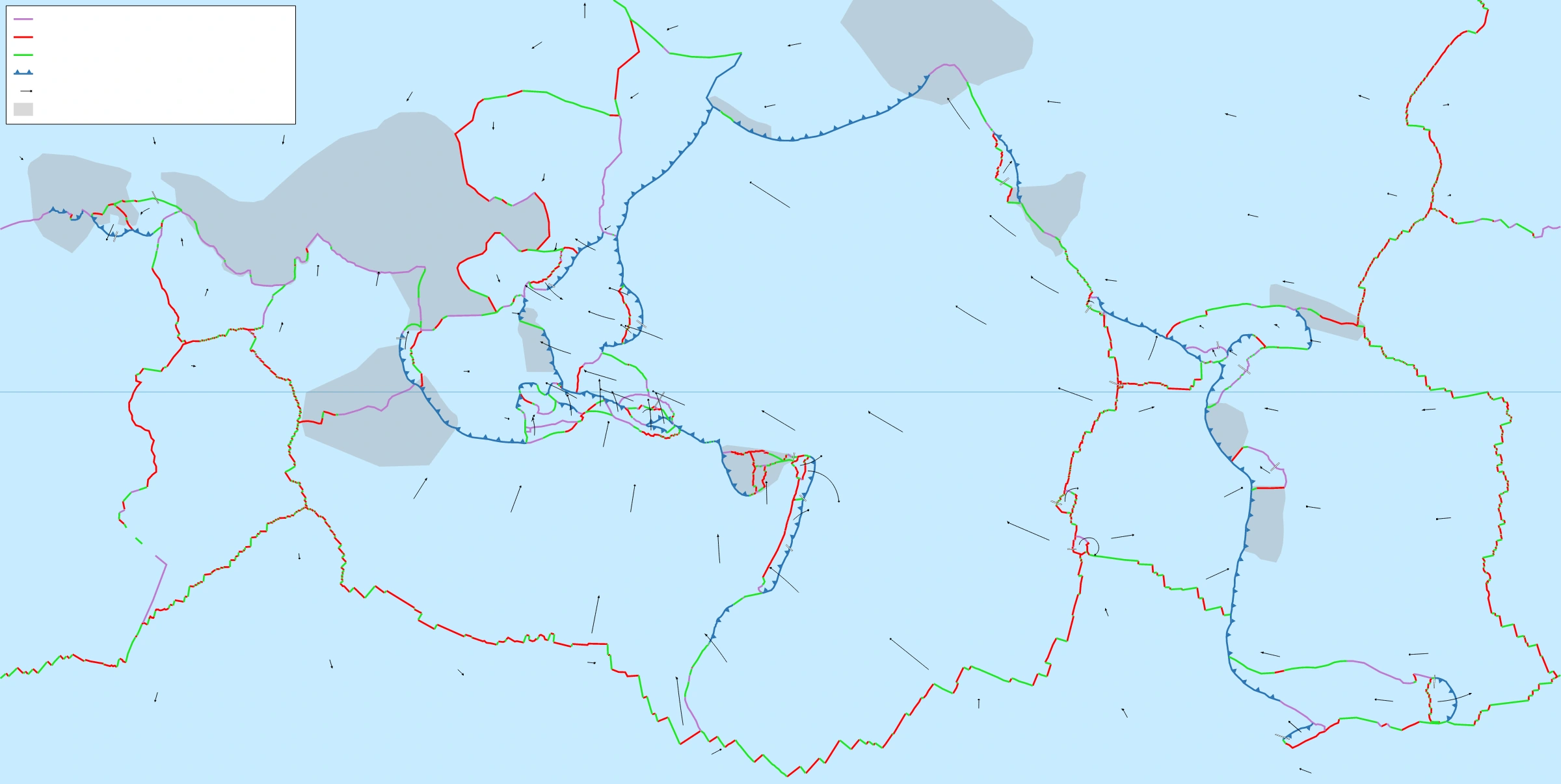
Map study
World tectonic plates: locate the Indian and Eurasian plates and distinguish convergent, divergent and transform boundaries through the legend.
- Read the source legend, scale and reference period before comparing regions.
- Connect spatial patterns to the processes discussed in this topic; this map is a study reference, not live operational data.
Credit: Eric Gaba (Sting) · CC BY-SA 2.5 · sourceConverted to WebP on an opaque white background; proportionally resized without cropping. Original cartography and legend retained.
1. Wegener’s hypothesis and the reconstruction of Pangaea
Continental drift challenged the earlier view that continents and ocean basins occupied essentially permanent positions. Wegener assembled evidence from continental outlines, rocks, fossils and ancient climates to argue that now-separated landmasses had once been connected. His contribution lay less in noticing similarities than in combining independent observations into a coherent global hypothesis.
Wegener called the former supercontinent Pangaea, meaning all Earth, and its surrounding ocean Panthalassa, meaning all sea. In the broad reconstruction used in physical geography, Pangaea differentiated into northern Laurasia and southern Gondwana, with the Tethys oceanic realm between them. Laurasia included the major ancestral landmasses of North America and Eurasia, while Gondwana included South America, Africa, Antarctica, Australia and India.
Pangaea assembled roughly 335–300 million years ago, and its major fragmentation began around 200 million years ago. These are approximate geological ages, not dates of a single event. Gondwana existed before the final assembly of Pangaea, so the familiar sequence of one supercontinent splitting neatly into two is a simplified teaching model.
The opening of the Atlantic separated the Americas from Europe and Africa. India travelled northward from Gondwana, while Australia eventually separated from Antarctica. These movements changed ocean gateways, atmospheric circulation, biological distributions and mountain-building environments.
- Pangaea: reconstructed supercontinent, not a lithospheric plate in the modern classification.
- Panthalassa: surrounding global ocean; the Pacific occupies much of its former realm.
- Tethys: an evolving oceanic realm whose closure contributed to the Alpine–Himalayan mountain system.
Timeline
Approximately 335–300 million years ago
Assembly of Pangaea through continental collisions.
Approximately 200 million years ago
Major fragmentation of Pangaea begins.
1912–1915
Wegener presents continental drift and publishes his major book.
Early 1960s
Seafloor spreading provides a mechanism for ocean-basin evolution.
1963–late 1960s
Magnetic-anomaly interpretation and other discoveries contribute to the consolidation of plate tectonics.
2. Continental fit and geological continuity
The best-known visual evidence is the complementary shape of eastern South America and western Africa. However, beaches and shorelines migrate through erosion, deposition and sea-level change. Reconstructions therefore obtain a more meaningful fit by comparing submerged continental margins rather than treating the present coastline as a fixed continental boundary.
In 1965, Edward Bullard and colleagues published a computer-assisted reconstruction of Atlantic continental margins. The improved fit reinforced Wegener’s geometrical argument, although some gaps and overlaps remain because continental edges undergo sediment accumulation, stretching and deformation. A jigsaw fit is supporting evidence, not sufficient proof by itself.
Geological continuity offers a stronger test: a valid reconstruction should bring together rocks of comparable age, structure and history. Geological belts in eastern South America correspond with belts in western Africa. Similarly, Appalachian structures in eastern North America can be related to parts of the Caledonian mountain system in Greenland, Scotland and Scandinavia.
Wegener also used mineral distributions. A standard textbook example is the association between Ghana’s placer gold and proposed source rocks in Brazil. This illustrates how continental reunion could explain a source–deposit relationship, but should be treated as historical supporting evidence rather than a decisive modern test. The key principle is convergence: geometrical, structural and chronological matches must support the same reconstruction.
- Continental shelf: gently sloping submerged margin adjoining a continent.
- Placer deposit: concentration of resistant, dense minerals by moving water or related sorting processes.
- Matching rocks must share geological history, not merely superficial appearance.
Simplified evolution from continental rifting to collision
- 1. Continental lithosphere stretches and develops a rift
- 2. Continental separation permits formation of a new ocean basin
- 3. Seafloor spreading widens the basin
- 4. Subduction consumes oceanic lithosphere where convergence develops
- 5. Ocean closure may culminate in continental collision and mountain building
3. Fossils and palaeoclimatic evidence
Fossil distributions provided evidence that widely separated continents were formerly connected. Mesosaurus, a small aquatic reptile associated with freshwater to restricted-water environments, occurs in Permian rocks of southern Africa and South America. Its distribution is difficult to explain by migration across a broad ocean, but becomes geographically coherent when the continents are joined.
Glossopteris, an extinct seed plant, is recorded across South America, Africa, India, Antarctica and Australia. Fossils of the terrestrial reptiles Lystrosaurus and Cynognathus provide additional correlations between parts of Gondwana. Such evidence is especially useful where organisms could not readily cross extensive ocean barriers. Earlier land-bridge explanations could account for individual similarities, but continental reconstruction explained several patterns together.
Late Palaeozoic glacial deposits occur across southern Africa, South America, India, Australia and Antarctica. Tillite is lithified glacial till, while striations preserve scratches made by debris carried beneath moving ice. When southern continents are reconstructed as Gondwana near the South Pole, the distribution of glacial deposits and many ice-flow directions becomes more consistent.
India’s Talchir Formation preserves important evidence of Gondwana glaciation, including characteristic glacial deposits. Conversely, coal-bearing sequences and plant fossils in Antarctica indicate climates different from those of today. Palaeoclimate alone cannot prove drift because global climate also changes; its strength comes from agreement with fossils, geology and later palaeomagnetic evidence.
- Mesosaurus: fossil correlation between southern Africa and South America.
- Glossopteris: a major floral indicator of Gondwana connections.
- Tillite: evidence of former glaciation, not evidence that the present location must always have been polar.
| Concept | Central proposition | Important limitation or scope |
|---|---|---|
| Continental drift | Continents change their relative positions | Wegener’s original driving forces were inadequate |
| Seafloor spreading | Oceanic crust forms at ridges and moves outward | Explains ocean-floor creation and spreading |
| Plate tectonics | Lithospheric plates interact at their boundaries | Integrates drift, spreading, subduction and many mountain-building processes |
4. Why Wegener’s mechanism was rejected
Wegener envisaged continents moving through denser oceanic material. He invoked a pole-fleeing force associated with Earth’s rotation and tidal forces arising from the gravitational attraction of the Moon and Sun. These forces were inadequate to produce the proposed movement, and the idea of continents ploughing through resistant oceanic crust posed a major mechanical difficulty.
His hypothesis also lacked the ocean-floor information needed to explain how ocean basins form and disappear. Mid-ocean ridges, global fracture systems, systematic seafloor ages and deep earthquake zones were not yet understood together. Thus, convincing observations of former continental connections coexisted with an unsatisfactory physical explanation.
Arthur Holmes suggested mantle convection as a possible driving process during the late 1920s and early 1930s. Later discoveries shifted the debate from whether continents could move to how the lithosphere behaves. For examination purposes, rejection of Wegener’s proposed forces must not be confused with rejection of the geological evidence for continental mobility.
- Main weakness: no physically adequate mechanism for the proposed drift.
- Incorrect modern inference: continents move independently across a stationary ocean floor.
- Correct distinction: mantle convection was a later explanatory development, not Wegener’s original mechanism.
5. Continental drift within modern plate tectonics
Post-war ocean-floor exploration identified interconnected mid-ocean ridges and deep-sea trenches. Harry Hess developed seafloor spreading in the early 1960s: new oceanic crust forms at ridges and moves away, while older oceanic lithosphere can return to the mantle at subduction zones. This supplied the missing framework for creating and consuming ocean basins.
In 1963, Frederick Vine and Drummond Matthews linked alternating magnetic anomalies on the seafloor to geomagnetic reversals and spreading. Lawrence Morley independently proposed the same basic interpretation. Broadly symmetrical magnetic patterns around ridges, together with increasing crustal age away from them, strongly supported seafloor spreading. Palaeomagnetic studies also showed that apparent polar-wander paths from different continents become more compatible when their relative movements are reconstructed.
Plate tectonics, consolidated in the late 1960s, treats the lithosphere as moving plates over a weaker, deformable asthenosphere. A plate may contain both continental and oceanic crust. Motion reflects interacting forces, particularly slab pull, gravitational sliding from elevated ridges commonly called ridge push, and mantle–plate coupling. The asthenosphere is predominantly solid, not a global molten layer.
Present-day satellite geodesy directly measures plate movements, generally at rates of millimetres to centimetres per year. The Atlantic illustrates ocean opening, whereas the Himalaya illustrates continental collision following ocean closure. Continental drift therefore remains a valid description of continental mobility, but plate tectonics is the more comprehensive explanatory theory.
- Divergent boundary: plates separate and new oceanic crust may form.
- Convergent boundary: plates approach, producing subduction or continental collision.
- Transform boundary: plates slide past one another without systematic creation or destruction of lithosphere.
Real-world case studies
India’s journey and the Himalaya
India separated from Madagascar approximately 88 million years ago and moved northward as intervening Tethyan oceanic lithosphere was consumed. India–Eurasia collision began broadly around 60–50 million years ago, although its precise timing and stages remain debated. Continued convergence drives Himalayan deformation and earthquakes. The Himalaya is therefore evidence of plate interaction, not simply of an isolated continent pushing through oceanic crust.
Iceland and the opening Atlantic
Iceland straddles the Mid-Atlantic Ridge between the North American and Eurasian plates. At Þingvellir, fissures and faulting provide an accessible example of extension. Iceland’s volcanism reflects both ridge processes and a mantle hotspot, so its exceptional elevation should not be attributed to divergence alone.
Previous year questions
UPSC Mains 2013 · GS-I
What do you understand by the theory of continental drift? Discuss the prominent evidences in its support.
- Explain Wegener’s hypothesis, Pangaea and continental separation.
- Discuss continental fit, matching geological belts, fossils and glacial evidence.
- Use South America–Africa, Glossopteris and Gondwana tillites as examples.
- Briefly distinguish weaknesses in the original mechanism from later validation through plate tectonics.
Practice questions
Practice MCQ 1
Consider the following statements: 1. Continental margins generally provide a more meaningful continental fit than present shorelines. 2. Mesosaurus fossils occur in both southern Africa and South America. 3. Wegener explained drift through seafloor spreading and subduction. Which statements are correct?
- A. 1 and 2 only
- B. 2 and 3 only
- C. 1 and 3 only
- D. 1, 2 and 3
Practice MCQ 2
Which observation most directly supports seafloor spreading?
- A. Similar coastlines on opposite sides of an ocean
- B. Broadly symmetrical magnetic anomalies across a mid-ocean ridge
- C. Coal deposits in Antarctica
- D. Glossopteris fossils on several southern continents
Practice MCQ 3
With reference to continental drift and plate tectonics, consider the following statements: 1. A single plate may include both continental and oceanic crust. 2. The asthenosphere is a continuous layer of fully molten rock. 3. Continental collision can follow the consumption of intervening oceanic lithosphere. Which statements are correct?
- A. 1 only
- B. 2 and 3 only
- C. 1 and 3 only
- D. 1, 2 and 3
Mains practice · Wegener’s continental drift hypothesis was stronger in its evidence than in its mechanism. Explain, and show how plate tectonics addressed this imbalance. Answer in 250 words.
- Introduce Wegener and Pangaea.
- Organise evidence into geometrical, geological, fossil and palaeoclimatic categories.
- Explain the inadequacy of pole-fleeing and tidal forces.
- Discuss seafloor spreading, magnetic anomalies and subduction.
- Distinguish continents from lithospheric plates and use India’s collision as an example.
- Conclude that plate tectonics incorporated continental mobility into a broader framework.
Further reading
- NCERT, Class XI, Fundamentals of Physical Geography, chapter Distribution of Oceans and Continents.
- US Geological Survey, This Dynamic Earth: The Story of Plate Tectonics.
- Geological Survey of India publications on Gondwana geology and the Talchir Formation.
- Alfred Wegener, The Origin of Continents and Oceans.
Preparing for UPSC Civil Services? Get classroom teaching, answer-writing evaluation and mentorship at Pragnya IAS Academy, Ashok Nagar — see why aspirants choose us for IAS coaching in Hyderabad.