

Satellite image of Cyclone Phailin near peak intensity at 1145 UTC on October 11, 2013, as viewed from a broadband visible channel imager on the Suomi NPP satellite that is sensitive to low-levels of
Credit: Colorado State Regional and Mesoscale Meteorology Branch, NOAA · Public domain · source

Tweet Text: RT @DM_Bhadrak: #OdishaPrepared4Fani CycloneFani Bhadrak Evacuation in #Basudevpur #CycloneShelter #OSDMA
Credit: Government of Odisha · CC BY 4.0 · source
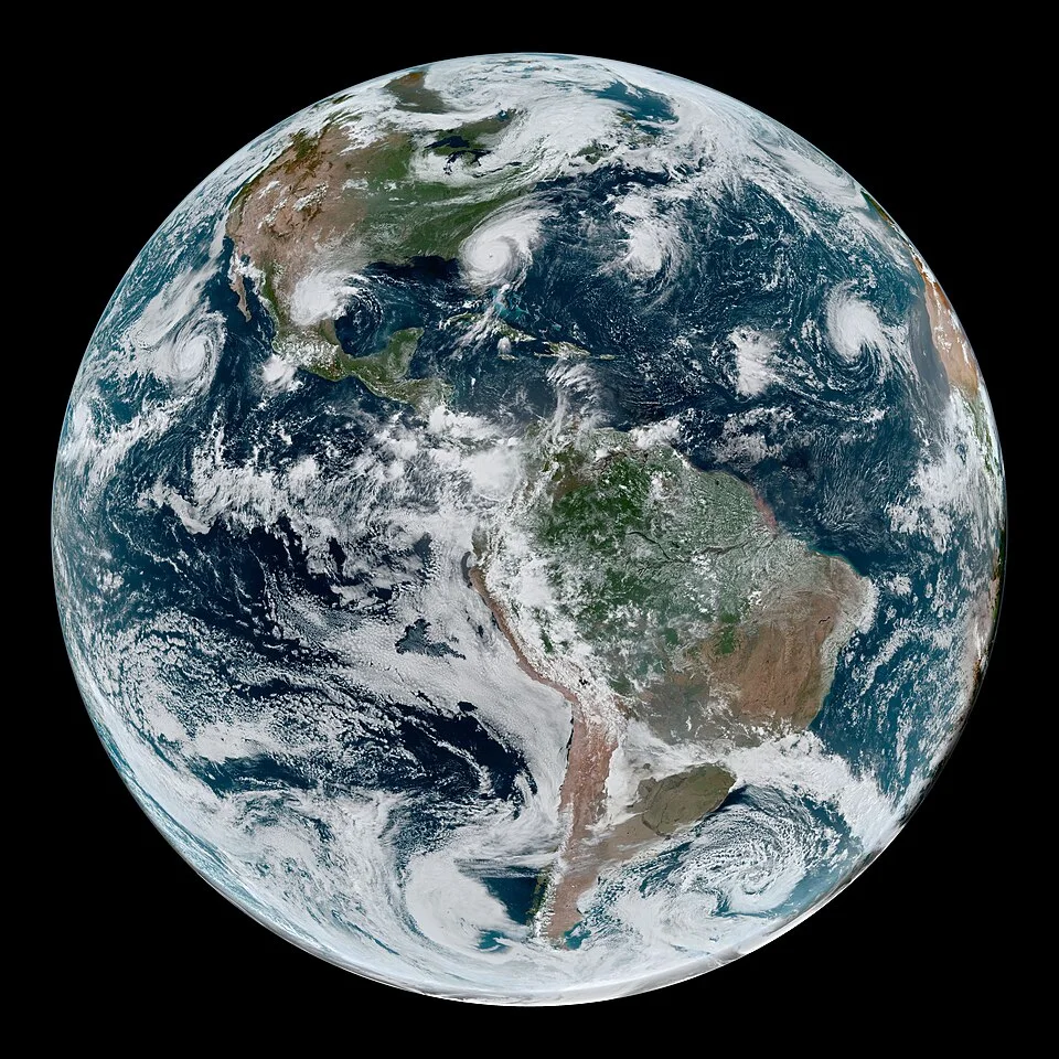
GOES-16-based simulated natural-colour image of Western Hemisphere tropical cyclones, 4 September 2019; a comparative example.
Credit: NASA Earth Observatory image by Joshua Stevens, using GOES 16 imagery courtesy of NOAA and the National Environmental Satellite, Data, and Information Service (NESDIS). Caption by Kathryn Hansen. · Public domain · sourceResized and converted to WebP; uncropped.
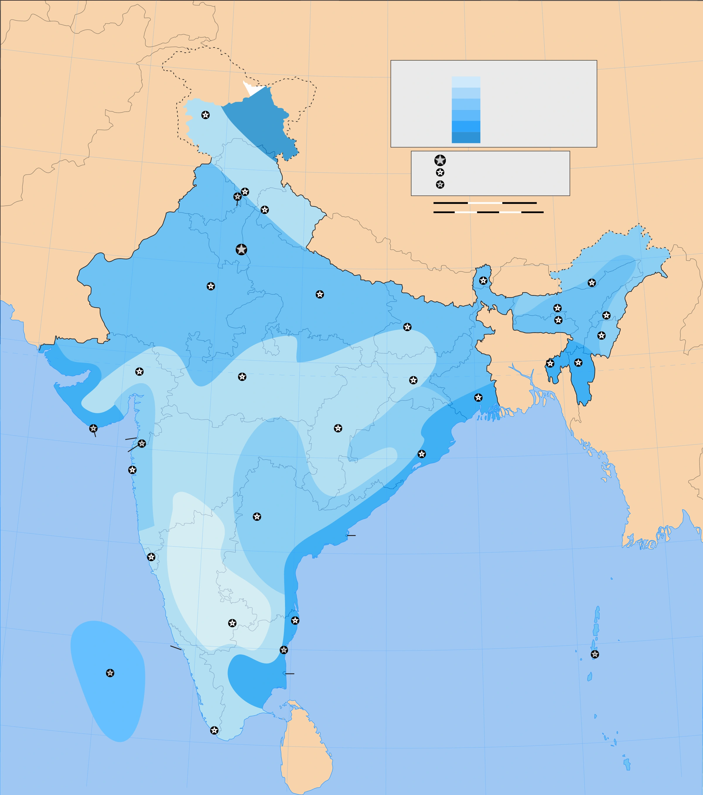
Map study
Wind and cyclone-risk reference zones: compare east coast, west coast and inland areas. Current official forecasts must guide operational decisions.
- Read the source legend and reference date before interpreting the map.
- Use spatial patterns to support topic revision; verify current official boundaries, designations and warnings separately.
Credit: Planemad · CC BY-SA 3.0 · sourceConverted to WebP on an opaque white background; proportionally resized without cropping. Original cartography and legend retained.
1. Nature, structure and energy source
A tropical cyclone is a non-frontal, synoptic-scale low-pressure system originating over tropical or subtropical waters, with organised deep convection and a closed surface wind circulation. It is called a hurricane in the North Atlantic and northeastern Pacific, a typhoon in the northwestern Pacific, and a cyclone in the Indian Ocean and South Pacific. These are regional names for the same basic phenomenon, not different categories of intensity.
A mature, intense cyclone commonly has an eye, an eyewall and spiral rainbands. The eye contains descending air and relatively light winds; skies may be partly clear. The surrounding eyewall contains vigorous rising air, deep cumulonimbus clouds, intense rainfall and usually the strongest winds. Rainbands extend outward and can produce heavy showers, squalls and local flooding. Weak or developing systems need not have a clearly defined eye.
The energy source is primarily heat and moisture transferred from the ocean. Moist air rises, cools and condenses, releasing latent heat that helps maintain a warm atmospheric column and low surface pressure. Air converges inward near the surface and diverges outward in the upper troposphere. Stronger winds increase ocean-to-atmosphere heat transfer, reinforcing the circulation under favourable conditions. Tropical cyclones therefore differ fundamentally from frontal systems driven mainly by horizontal temperature contrasts.
- Central pressure alone does not determine damage: storm size, wind distribution, translation speed and coastal exposure also matter.
- Calm conditions during eye passage are temporary; dangerous winds can return abruptly as the opposite eyewall arrives.
2. Conditions for formation and intensification
Formation usually requires warm ocean water, abundant lower- and middle-tropospheric moisture, atmospheric instability, a pre-existing disturbance and sufficient planetary rotation. A sea-surface temperature near 26.5°C or above is a useful textbook threshold. Warm water extending to roughly 50–60 metres or deeper helps prevent cyclone-driven mixing from quickly exposing colder water. Ocean heat content is consequently often more informative than surface temperature alone.
The Coriolis force helps organise inward-moving air into a rotating circulation. Because it is zero at the equator and weak nearby, tropical cyclones rarely originate within about 5° latitude of it. A pre-existing low-pressure area or tropical wave supplies initial convergence and relative vorticity. Moist middle levels limit the disruptive effects of dry-air entrainment, while upper-level divergence allows rising air to escape from the developing system.
Low vertical wind shear is especially favourable: a large change in wind speed or direction with height can tilt the vortex and separate thunderstorms from the surface centre. Warm water alone is therefore insufficient. Rapid intensification commonly means an increase in maximum sustained winds of at least 30 knots in 24 hours. It becomes more likely when high ocean heat content, weak shear and a favourable internal structure coincide.
- Cyclones usually weaken over land because moisture and heat supplies are reduced and surface friction increases.
- Cold water, dry air and strong wind shear can weaken a cyclone even before landfall.
Simplified development of a tropical cyclone
- 1. A pre-existing disturbance develops over a warm ocean under favourable moisture and wind-shear conditions.
- 2. Surface convergence supplies warm, moist air to organised thunderstorms.
- 3. Condensation releases latent heat and helps establish a warm-core low-pressure system.
- 4. Coriolis force organises the inflow into a rotating circulation.
- 5. Continued oceanic heat supply and upper-level outflow support intensification.
- 6. Land interaction, cold water, dry air or strong wind shear eventually promote weakening.
3. Global distribution, movement and Indian seasonality
Major cyclone basins include the North Atlantic, northeastern and northwestern Pacific, North Indian Ocean, southwest Indian Ocean and the Australian–South Pacific region. Formation is concentrated broadly between 5° and 30° latitude. The northwestern Pacific is the most active basin. The southeastern Pacific and South Atlantic are generally unfavourable because of combinations of cool water, strong shear and an absence of suitable disturbances; however, South Atlantic occurrences are not impossible.
Cyclones are steered mainly by the surrounding atmospheric flow, including subtropical ridges and mid-latitude troughs. Many initially move westward with tropical easterlies, then turn poleward and sometimes eastward as they encounter westerlies. This recurvature is a common pattern, not a fixed rule. Some systems stall, loop or change direction. Landfall is the crossing of the coastline by the cyclone’s surface centre, although dangerous weather can begin much earlier.
The North Indian Ocean has two principal activity periods: April–June and October–December, with prominent peaks around May and November. Strong vertical shear during the southwest monsoon suppresses the development of many intense tropical cyclones, although monsoon depressions remain important rain-bearing systems. The Bay of Bengal generally supports more cyclone formation than the Arabian Sea. Moisture availability, disturbances, circulation and ocean conditions all contribute to this contrast.
- Odisha, Andhra Pradesh, West Bengal and Tamil Nadu are highly exposed on the east coast; Gujarat and other western coastal areas also face risk.
- Arabian Sea cyclone risk must not be treated as negligible: Tauktae in 2021 and Biparjoy in 2023 are important examples.
| Category | Wind speed |
|---|---|
| Deep depression | 28–33 knots |
| Cyclonic storm | 34–47 knots |
| Severe cyclonic storm | 48–63 knots |
| Very severe cyclonic storm | 64–89 knots |
| Extremely severe cyclonic storm | 90–119 knots |
| Super cyclonic storm | 120 knots or more |
4. Hazards, coastal vulnerability and climate change
Cyclone hazards include destructive winds, wind-driven waves, storm surge, intense rainfall and inland flooding. Heavy rainfall can trigger landslides in hill regions far from the coast. A storm surge is the abnormal rise of sea level associated with a storm, above the predicted astronomical tide. Wind stress pushing water coastward is its main driver, while low atmospheric pressure also contributes. Storm tide combines the astronomical tide and storm surge.
Surge severity depends on storm intensity and size, approach angle, forward motion, coastal shape, shelf depth and tidal timing. Broad, shallow continental shelves and funnel-shaped bays favour large water accumulation. The northern Bay of Bengal is particularly vulnerable because of its coastal geometry, low-lying deltas, dense population and extensive settlements. Saline inundation damages crops, drinking-water sources and soils; transport disruption and power failures can magnify losses.
Climate change does not imply a uniform increase in cyclone numbers everywhere. Warmer oceans and greater atmospheric moisture can support higher rainfall rates and stronger peak intensities. Assessments project an increasing proportion of intense tropical cyclones globally, while changes in total frequency remain more uncertain and basin-dependent. Sea-level rise increases coastal inundation risk even without a stronger storm. The effects of warming must be distinguished from natural variability and growing coastal exposure.
- Storm surge is not a tsunami: tsunami waves usually originate from sudden displacement of water, commonly during submarine earthquakes.
- Track forecasts and intensity forecasts have different uncertainties; rapid intensification is a major operational challenge.
5. Monitoring, warnings and risk reduction in India
The India Meteorological Department is India’s principal cyclone-warning agency. Its Regional Specialised Meteorological Centre in New Delhi provides tropical cyclone advisories for the North Indian Ocean. Observations come from satellites, Doppler weather radars, ocean buoys, ships and coastal stations, supported by numerical models. Cyclone names are assigned from lists contributed by the WMO/ESCAP Panel’s member countries; naming improves communication and does not indicate intensity.
IMD’s four-stage warning system comprises a pre-cyclone watch, cyclone alert, cyclone warning and post-landfall outlook. These are normally issued about 72, 48, 24 and 12 hours respectively before the relevant anticipated onset or landfall stage. Forecasts support evacuation, fishing restrictions, port preparedness and emergency response. IMD’s wind-based intensity categories should not be confused with its colour-coded warning messages, which communicate expected impacts and required action.
Risk reduction combines timely evacuation with resilient buildings, shelters, reliable communication, protected utilities and appropriate coastal land-use planning. Mangroves and dunes can reduce some wave impacts but cannot replace engineered protection or evacuation. The National Cyclone Risk Mitigation Project has supported measures such as shelters, evacuation routes and early-warning systems. Effective preparedness must include fishers, persons with disabilities, migrants, livestock owners and isolated coastal communities.
- The Disaster Management Act, 2005 provides the institutional framework for national, state and district disaster-management authorities.
- A forecast becomes useful only when warnings reach exposed people in understandable language and lead to timely protective action.
Multiple Tropical Cyclones: Shared Conditions, Distinct Systems
The supplied metadata identifies several tropical cyclones active across the Atlantic and eastern Pacific, including hurricanes and tropical storms. This provides a comparative example of how favourable seasonal conditions can support multiple systems simultaneously. A loose geographical chain does not mean the storms form a single circulation or share one track. Each cyclone depends on its own environment: adequate oceanic heat, moist air, a pre-existing disturbance, sufficient Coriolis force and generally low vertical wind shear. Latent heat released through condensation helps sustain the warm-core circulation.
For India, the relevant basins are the Bay of Bengal and Arabian Sea, where cyclone activity typically peaks before and after the southwest monsoon. The Western Hemisphere example illustrates general processes, not evidence about a particular Indian cyclone. The metadata describes a simulated natural-colour satellite product, which is useful for studying cloud organisation and storm distribution; it cannot alone establish surface wind speed, central pressure or storm-surge height. Those assessments require additional observations and analysis. Coastal impacts also depend on storm size, track, rainfall, bathymetry, tides and settlement exposure, rather than intensity labels alone.
- Hurricane and cyclone are regional terms for the same broad phenomenon; Atlantic hurricane categories should not be equated directly with IMD classifications.
- Coriolis force supports rotation but does not supply storm energy; tropical cyclogenesis is therefore uncommon very close to the equator.
- Unlike frontal temperate cyclones, tropical cyclones are warm-core systems; their hazards include storm surge, destructive winds and inland flooding.
Real-world case studies
Cyclone Phailin, Odisha, 2013
Phailin made landfall near Gopalpur on 12 October 2013. Evacuation of roughly one million people, supported by forecasts, cyclone shelters and coordinated administration, sharply limited mortality compared with the 1999 Odisha super cyclone. The case demonstrates how preparedness can reduce deaths even when property and agricultural losses remain substantial.
Cyclone Catarina, Brazil, 2004
Catarina struck southern Brazil in March 2004 as a rare South Atlantic hurricane. Unusually favourable ocean–atmosphere conditions enabled its development in a normally hostile basin. It illustrates why geographical rules about cyclone absence should be framed as strong tendencies rather than absolute prohibitions.
Previous year questions
Source-linked detailed analyses are available above.
Practice questions
Practice MCQ 1
Which of the following conditions generally favour tropical cyclone formation? 1. Weak vertical wind shear 2. Moist middle troposphere 3. Location exactly on the equator Select the correct answer.
- A. 1 and 2 only
- B. 2 and 3 only
- C. 1 and 3 only
- D. 1, 2 and 3
Practice MCQ 2
With reference to storm surge, consider the following statements: 1. It is measured relative to the predicted astronomical tide. 2. A broad, shallow continental shelf can increase its severity. 3. It is primarily caused by submarine earthquakes. Which statements are correct?
- A. 1 only
- B. 1 and 2 only
- C. 2 and 3 only
- D. 1, 2 and 3
Practice MCQ 3
Which description of a mature tropical cyclone is correct?
- A. Its eye normally contains the strongest surface winds.
- B. Its circulation is clockwise in the Northern Hemisphere.
- C. Its eyewall contains vigorous ascent and usually the strongest winds.
- D. Its principal energy source is the collision of cold and warm fronts.
Mains practice · Explain the geographical factors responsible for tropical cyclone formation and assess why similar-intensity cyclones can produce different disaster outcomes along Indian coasts. Answer in 250 words.
- Explain ocean heat content, moisture, Coriolis force, initial disturbance, weak shear and upper-level outflow.
- Discuss Indian cyclone seasonality and the Bay of Bengal–Arabian Sea contrast.
- Differentiate wind damage, rainfall flooding and storm surge.
- Analyse shelf depth, coastal geometry, tidal timing, deltas and settlement exposure.
- Use Phailin to demonstrate the importance of evacuation, shelters and last-mile warnings.
- Conclude with resilient infrastructure, ecosystem protection and inclusive preparedness.
Further reading
- NCERT, Class XI, Fundamentals of Physical Geography: Atmospheric Circulation and Weather Systems.
- India Meteorological Department, RSMC New Delhi: cyclone FAQs, classification and annual cyclone reports.
- National Disaster Management Authority: National Disaster Management Guidelines on Management of Cyclones.
- World Meteorological Organization: Tropical Cyclone Programme.
- IPCC Sixth Assessment Report, Working Group I: Weather and Climate Extreme Events in a Changing Climate.
- https://commons.wikimedia.org/wiki/File:Turbulent_Tropical_Skies.jpg
Preparing for UPSC Civil Services? Get classroom teaching, answer-writing evaluation and mentorship at Pragnya IAS Academy, Ashok Nagar — see why aspirants choose us for IAS coaching in Hyderabad.