
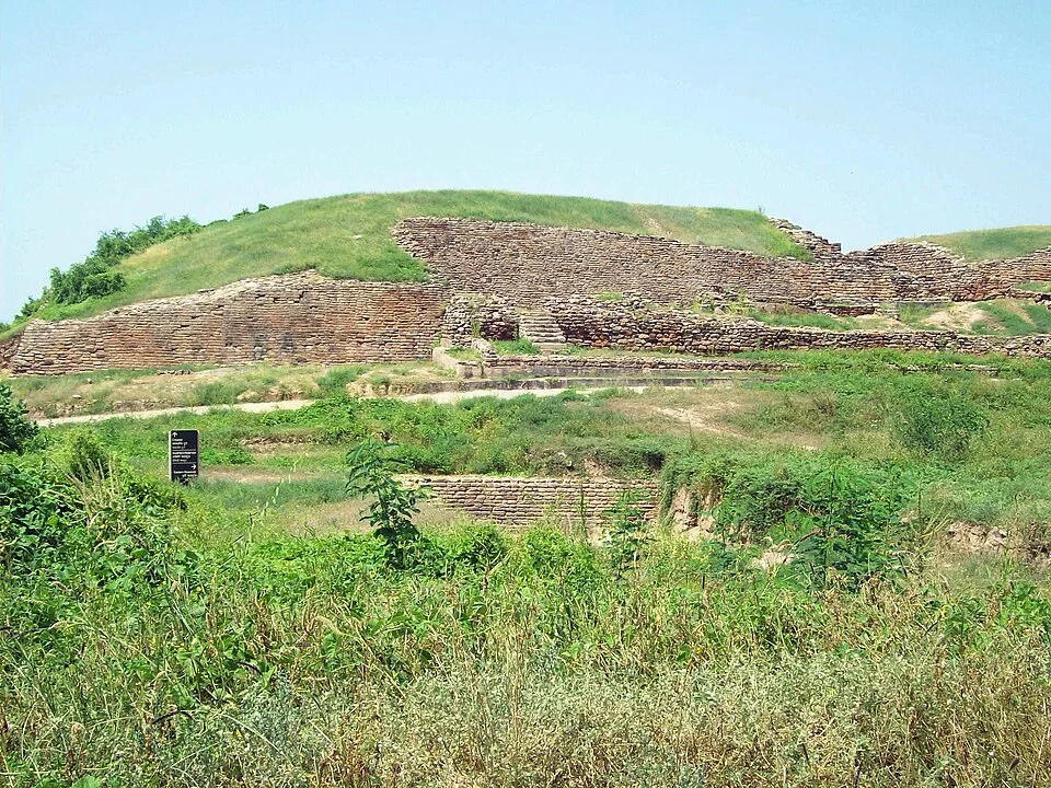
Dholavira, a Harappan urban site in Gujarat’s Kachchh region.
Credit: Himalyan · CC BY-SA 3.0 · sourceResized and converted to WebP; uncropped.
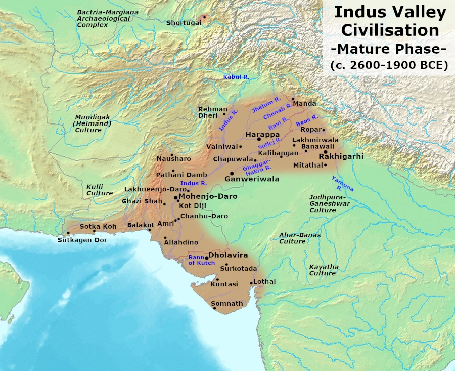
Map study
Mature Harappan civilisation, c. 2600–1900 BCE: settlement distribution, not the territory of a single empire.
- Read the source date and legend before interpreting territorial extent.
- Compare core regions, neighbouring powers and geographic barriers; historical borders and influence are approximate and changed over time.
Credit: Avantiputra7 · CC BY-SA 3.0 · sourceConverted to WebP on an opaque white background; proportionally resized without cropping. Original cartography and legend retained.
1. Location, discovery and historical setting
Dholavira lies on Khadir Bet in the Great Rann of Kachchh, within present-day Gujarat. Its setting differs markedly from the riverine landscapes of Harappa and Mohenjo-daro. The settlement occupied a position between two seasonal streams, the Mansar to the north and the Manhar to the south. Access to seasonal runoff, nearby stone and routes connecting Kachchh with other Harappan regions helped shape its growth. The modern salt-desert landscape should not, however, be projected unchanged into the third millennium BCE.
J. P. Joshi identified the site in 1967–68. Systematic excavations directed by R. S. Bisht for the Archaeological Survey of India during 1990–2005 revealed a long sequence of construction, rebuilding and changes in occupation. UNESCO describes the site’s broad occupation span as approximately 3000–1500 BCE. For examination purposes, distinguish this local sequence from the generally accepted Mature Harappan period of approximately 2600–1900 BCE.
Dholavira was among the major urban centres of the Indus civilisation and one of its most important sites within present-day India. Its trajectory includes urban expansion, changes in fortification and water infrastructure, and a later contraction or transformation of settlement. This sequence shows that Harappan urbanism was neither static nor identical across regions.
- Map association: Dholavira–Khadir Bet–Great Rann of Kachchh–Gujarat.
- Do not confuse Dholavira with Lothal, another Harappan site in Gujarat associated with a basin conventionally interpreted as a dockyard.
- The local archaeological sequence extends beyond the peak urban phase of the civilisation.
Timeline
Approximately 3000 BCE
Beginning of occupation within UNESCO’s broad chronology for Dholavira.
Approximately 2600–1900 BCE
Mature Harappan period, providing the wider chronological context for Dholavira’s major urban development.
Approximately 1500 BCE
End of occupation in the broad chronology cited by UNESCO, following substantial settlement transformation.
1967–68
J. P. Joshi identifies the archaeological site.
1990–2005
Major ASI excavations under R. S. Bisht document its planning, reservoirs and occupation sequence.
2021
Dholavira: a Harappan City is inscribed on the UNESCO World Heritage List.
2. Urban planning and stone architecture
Dholavira is commonly described through three broad divisions: the citadel, middle town and lower town. Its actual layout was more complex, with separately enclosed components and subdivisions. The citadel incorporated a strongly fortified castle and an adjoining bailey. Internal walls, gateways, streets and open spaces created a visibly differentiated urban landscape. Thus, the familiar three-part description is useful for Prelims but should not obscure the settlement’s finer architectural organisation.
A striking feature is the extensive use of locally available stone, including dressed stone in important structures. Mud brick and other building materials were also employed; Dholavira was not exclusively a stone-built city. Its masonry contrasts with the prominence of baked-brick architecture at several other major Harappan sites. This difference demonstrates regional adaptation within a civilisation that nevertheless shared seals, weights, craft traditions and other cultural practices.
Large open grounds, sometimes described as stadia, lay within the urban complex and may have served ceremonial gatherings or other collective activities. Monumental gateways and carefully organised enclosures indicate substantial planning and labour mobilisation. However, archaeological labels such as castle or citadel do not prove the existence of a king, palace or military state in the conventional historical sense. The precise political organisation of Harappan society remains uncertain.
- High-yield architectural identifiers: stone masonry, multiple fortified divisions and monumental gateways.
- The middle town is a particularly useful feature when distinguishing Dholavira in site-based questions.
- Urban differentiation suggests organised authority, but the identities and powers of governing groups remain unknown.
Simplified working of Dholavira’s water-harvesting system
- 1. Rainfall generates runoff across the catchment and flow in seasonal streams.
- 2. Dams and diversion structures intercept part of this water.
- 3. Channels convey collected water towards storage structures.
- 4. Reservoirs retain water for use beyond the rainy season.
- 5. Access structures, upkeep and sediment clearance support continued use.
3. Water harvesting and environmental adaptation
Dholavira’s best-known achievement is its integrated system for collecting, storing and distributing water in a region with limited and strongly seasonal rainfall. Its inhabitants captured runoff from the surrounding catchment and diverted flows from the seasonal streams through dams and channels. Reservoirs within the settlement complex provided storage across dry periods. Water availability was therefore addressed through a coordinated landscape-scale system rather than reliance on a single well or river.
Excavations exposed large reservoirs, stone-lined structures, rock-cut components, channels, drains and stepped access. Reservoirs occupied substantial areas around the built-up settlement. The combination of natural topography and engineered structures helped direct water towards storage spaces. Wells supplemented these arrangements. Although water-related structures could serve different functions, stormwater collection should not automatically be equated with sewage disposal; each structure requires interpretation from its context.
The system is evidence of technical knowledge, investment in public infrastructure and the capacity to organise construction and maintenance. It also provides an important example of adaptation to environmental constraints. Nevertheless, sophisticated storage could not eliminate vulnerability to prolonged ecological stress or disruptions in maintenance and exchange. Explanations of Dholavira’s eventual decline should consider interacting environmental, economic and social changes rather than assign the outcome to one securely established cause.
- Core process: catchment runoff and seasonal stream flow were collected, channelled and stored.
- Exam association: Dholavira is particularly noted for dams, channels and interconnected water-storage arrangements.
- Contemporary relevance: catchment protection, decentralised storage and water-sensitive planning, without treating ancient designs as universally transferable.
| Site | Present-day location | Key examination association |
|---|---|---|
| Dholavira | Gujarat, India | Stone architecture, reservoirs, differentiated urban divisions and ten-sign display |
| Lothal | Gujarat, India | Basin conventionally interpreted as a dockyard; bead production |
| Kalibangan | Rajasthan, India | Evidence of a ploughed field and fire altars |
| Mohenjo-daro | Sindh, Pakistan | Great Bath and extensive baked-brick architecture |
| Harappa | Punjab, Pakistan | Type-site of the civilisation; cemeteries and major urban remains |
4. Script, crafts, exchange and funerary evidence
Near the northern gateway of the castle, excavators recovered ten large signs of the Harappan script, generally interpreted as a signboard. The signs were formed from pieces of white gypsum and probably mounted on a wooden support that has not survived. Their unusual size suggests that they were intended to be visible rather than confined to a small seal. Since the Harappan script remains undeciphered, the text cannot reliably be identified as a royal name, place-name or administrative instruction.
Seals, beads, ornaments, pottery and objects made from materials such as stone, shell and copper reflect craft activity and participation in wider Harappan networks. Dholavira’s location connected it with resource zones and routes extending through Gujarat and beyond. Wider Indus contacts with western Asia provide a relevant background, but every imported-looking material or artefact should not automatically be treated as proof of direct overseas trade by Dholavira itself.
The cemetery contains varied funerary structures, including monumental forms and memorial deposits without human remains, often described as cenotaphs. Such evidence complicates any assumption that Harappan mortuary practices were uniform. Differences in burial architecture may illuminate ritual traditions and social distinctions, but they do not establish specific beliefs about deities or the afterlife. Material evidence supports cautious interpretation rather than confident reconstruction of an otherwise undocumented religion.
- The ten-sign display is a distinctive Dholavira discovery; its meaning remains unknown.
- Seals and inscriptions are not deciphered historical records from which named rulers can be reconstructed.
- Funerary monuments and cenotaphs should be distinguished from ordinary residential architecture.
5. Heritage significance and examination approach
Dholavira: a Harappan City entered the UNESCO World Heritage List in 2021 under criteria (iii) and (iv), recognising its testimony to Harappan civilisation and its outstanding urban and architectural remains. It became India’s fortieth World Heritage property at the time of inscription. The recognised property brings together the fortified city and its associated cemetery, allowing urban, technological and mortuary evidence to be considered within one archaeological landscape.
Conservation priorities include protecting exposed masonry, managing erosion, maintaining the setting of reservoirs and regulating visitor movement. Tourism can create opportunities for neighbouring communities, but poorly planned construction or excessive pressure can damage the archaeological landscape. Interpretation should explain both the site’s achievements and the limits of present knowledge, especially concerning the script, political institutions and causes of decline.
For UPSC, prepare Dholavira through linked identifiers rather than isolated superlatives: Gujarat, Khadir Bet, seasonal streams, stone architecture, differentiated urban divisions, water reservoirs, the large signboard and UNESCO recognition. In analytical answers, use it to demonstrate regional diversity within Harappan civilisation, environment-sensitive planning and the importance of public infrastructure. Avoid unsupported claims that it possessed a proven dockyard, deciphered inscription or securely identified royal palace.
- Prelims focus: location, site-feature matching, chronology and archaeological discoveries.
- Mains linkage: urbanisation, ecological adaptation, heritage management and continuity versus change in settlement systems.
Dholavira: Urban Planning and Water Adaptation
Dholavira, on Khadir Bet in the Rann of Kachchh, demonstrates how Harappan urbanism adapted to local environmental conditions. Its substantial use of stone distinguishes it from the predominantly brick-built remains familiar from several other Indus cities. Fortified divisions, gateways and differentiated urban spaces reveal organised planning, but these features do not by themselves establish a particular form of government or identify the groups occupying each enclosure. The supplied metadata identifies Dholavira; it does not specify which structure the photograph documents.
Water management is central to understanding the settlement. Reservoirs, channels and arrangements for capturing seasonal flows helped address unreliable water availability. These works should be studied as an integrated system linking terrain, runoff and storage, rather than simply as examples of drainage. Dholavira also belongs within the wider Harappan world of craft production and exchange, not as an isolated desert settlement. Its large signboard provides evidence for the prominent use of Indus signs, but the script remains undeciphered: neither the message nor its administrative purpose can be securely stated. UNESCO inscription in 2021 recognises the site’s heritage significance; it is not the date of its discovery or occupation.
- Prelims distinction: Dholavira is in Gujarat, not Rajasthan; do not confuse its reservoirs with Lothal’s commonly described dockyard.
- Mains linkage: Use Dholavira to explain environmental adaptation and urban infrastructure, while avoiding unsupported claims that every Harappan city followed an identical plan.
- Evidence limit: Monumental architecture suggests coordinated labour and resources, but does not prove rule by kings, priests or a modern-style municipal authority.
Real-world case studies
Dholavira’s reservoirs: planning for seasonal scarcity
Dholavira integrated reservoirs with the organisation of the city instead of treating water storage as an incidental household activity. Its combination of stream diversion, runoff collection and substantial storage illustrates how infrastructure could support urban life in a seasonally dry setting. The present-day lesson is to plan settlements around catchments and reliable water budgets, not merely expand supply after scarcity emerges.
The gateway signboard: evidence and interpretive limits
The ten large gypsum signs found near the castle’s northern gateway offer rare evidence of large-format writing in a Harappan urban setting. Their placement and scale support an interpretation involving public visibility. However, because the script is undeciphered, assigning a specific message would exceed the evidence. This is a useful example of separating archaeological observation from historical inference.
Previous year questions
UPSC Prelims 2021
Which ancient town is well known for an elaborate water-harvesting and management system involving a series of dams and channels carrying water into connected reservoirs?
- A. Dholavira
- B. Kalibangan
- C. Rakhigarhi
- D. Ropar
Practice questions
Practice MCQ 1
Consider the following statements about Dholavira: 1. It is located on Khadir Bet in the Great Rann of Kachchh. 2. Its urban architecture made extensive use of stone. 3. Its large Harappan signboard has been conclusively deciphered. Which statements are correct?
- A. 1 and 2 only
- B. 2 and 3 only
- C. 1 and 3 only
- D. 1, 2 and 3
Practice MCQ 2
Which pair of seasonal streams is associated with Dholavira?
- A. Ravi and Beas
- B. Mansar and Manhar
- C. Banas and Chambal
- D. Narmada and Tapi
Practice MCQ 3
Which interpretation of archaeological evidence from Dholavira is the most defensible?
- A. Its fortified castle establishes the name and dynasty of its ruler.
- B. Its reservoirs demonstrate that prolonged water stress was impossible.
- C. Its large signboard suggests visible communication, although its message remains unknown.
- D. Its stone buildings prove that it belonged to a civilisation unrelated to Harappa.
Mains practice · Dholavira illustrates both the shared features and regional adaptability of Harappan urbanism. Discuss with reference to its architecture, water management and material culture. Answer in 250 words.
- Locate Dholavira on Khadir Bet and place its urban development within the Harappan chronology.
- Explain shared features such as planned settlement, seals, script, specialised crafts and exchange.
- Discuss regional features: extensive stone masonry, multiple enclosed divisions and local environmental adaptation.
- Explain the integration of catchments, seasonal streams, diversion structures and reservoirs.
- Use the signboard and funerary monuments to illustrate distinctive evidence without claiming decipherment or certainty about beliefs.
- Conclude that common cultural practices coexisted with locally adapted urban forms.
Further reading
- NCERT, Themes in Indian History, Part I: Bricks, Beads and Bones.
- UNESCO World Heritage Centre: Dholavira: a Harappan City, property description and Statement of Outstanding Universal Value.
- Archaeological Survey of India: Dholavira site information and excavation publications.
- R. S. Bisht, Excavations at Dholavira (1989–90 to 2004–05), Archaeological Survey of India.
- UNESCO World Heritage Centre: Dholavira nomination dossier and ICOMOS evaluation.
- https://commons.wikimedia.org/wiki/File:Dholavira_gujarat.jpg
Preparing for UPSC Civil Services? Get classroom teaching, answer-writing evaluation and mentorship at Pragnya IAS Academy, Ashok Nagar — see why aspirants choose us for IAS coaching in Hyderabad.