

Dockyard in Lothal. Indus valley Civilization township
Credit: Jashjashjash · CC BY-SA 4.0 · source

Stone beads from Lothal
Credit: Ministry of Culture · Public domain · source
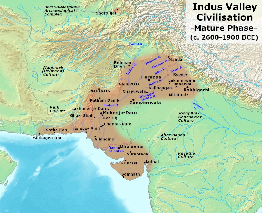
Map study
Mature Harappan civilisation, c. 2600–1900 BCE: settlement distribution, not the territory of a single empire.
- Read the source date and legend before interpreting territorial extent.
- Compare core regions, neighbouring powers and geographic barriers; historical borders and influence are approximate and changed over time.
Credit: Avantiputra7 · CC BY-SA 3.0 · sourceConverted to WebP on an opaque white background; proportionally resized without cropping. Original cartography and legend retained.
1. Location, chronology and discovery
Lothal lies near Saragwala village in present-day Ahmedabad district of Gujarat. Its setting in the Bhogavo–Sabarmati drainage and estuarine region connected it with the Gulf of Khambhat, formerly called the Gulf of Cambay. The relationship between river channels, tidal waters and the settlement is central to interpreting its economy. The modern distance from the sea should not be used to reconstruct ancient accessibility without considering channel migration, sediment deposition and changes in the coastline.
The site belongs to the southern distribution of the Harappan civilisation. Its principal urban occupation is generally placed within the Mature Harappan period, conventionally dated around 2600–1900 BCE, with later occupation continuing into the early second millennium BCE. Site-specific dates vary across publications, and broad cultural phases are more useful than treating one narrow date range as universally accepted. Pottery and other remains also indicate interactions between Harappan traditions and regional communities in Gujarat.
Following its identification in 1954, the Archaeological Survey of India excavated Lothal under S. R. Rao between 1955 and 1962. These excavations substantially expanded knowledge of Harappan settlements within post-Independence India. Lothal demonstrated that Harappan urbanism was not confined to the Indus plain: settlements in Gujarat linked inland production, coastal resources and long-distance exchange.
- Map association: Lothal—Gujarat—Gulf of Khambhat.
- Do not confuse Lothal with Dholavira, which is situated on Khadir Bet in the Rann of Kachchh.
Timeline
Third millennium BCE
Lothal developed as a Harappan settlement with specialised production and exchange connections.
After about 1900 BCE
Later occupation continued amid the wider transformation of Mature Harappan urban networks.
1954
Lothal was identified during archaeological exploration.
1955–1962
ASI excavations were conducted under S. R. Rao.
2014
The Archaeological Site of Lothal was added to India’s UNESCO Tentative List.
2. Settlement planning and civic infrastructure
Lothal was a relatively compact settlement with differentiated residential, productive and administrative spaces. Excavators distinguished an elevated area, often called the acropolis, from a lower town. Raised platforms supported important structures and offered some protection against flooding. Although terms such as acropolis and citadel are useful descriptive labels, they do not independently prove the existence of a king, palace or particular political system.
The settlement displayed familiar Harappan planning practices, including streets, lanes, brick-built structures, bathing arrangements and drains. Mud bricks were widely used, while baked bricks were employed in installations requiring greater resistance to water. Domestic wastewater could pass through drains and collection arrangements before entering larger channels. Such features indicate organised construction and maintenance, although surviving remains cannot reveal the precise institutional arrangements responsible for them.
A substantial platform near the basin has been interpreted as supporting a warehouse. Its layout and associated finds, including sealings, suggest the storage and handling of commodities. The identification is strongest when architecture and artefacts are considered together. It should not be imagined as a surviving roofed warehouse: much of what archaeologists recover consists of foundations, platforms and traces of superstructures.
Flood deposits and rebuilding episodes show that settlement planning involved repeated responses to environmental stress. Lothal therefore illustrates both the capabilities and limitations of Harappan civic engineering. Planned construction did not eliminate vulnerability to river flooding, siltation or changing waterways.
Reconstructing Lothal’s craft economy
- 1. Procurement of stone, shell and other raw materials
- 2. Processing by specialised craftspeople
- 3. Finishing and assessment using shared measurement practices
- 4. Storage and handling of goods
- 5. Distribution through regional and long-distance exchange networks
3. The basin and the dockyard debate
Lothal’s best-known feature is a large rectangular brick-lined basin along the eastern side of the settlement, approximately 214 metres long and 36 metres wide. S. R. Rao interpreted it as a dockyard connected to a navigable channel. Its substantial masonry, proposed arrangements for admitting and releasing water, and proximity to a probable warehouse underpin the conventional port interpretation.
Under this interpretation, vessels could enter a sheltered basin for loading and unloading while water-control arrangements helped manage tidal variation. Such an installation would have been particularly significant in the Gulf of Khambhat region, where tidal conditions are demanding. Combined with evidence for commodity production and exchange, the basin supports the reconstruction of Lothal as a trading settlement with access to waterways.
However, the dockyard identification is not unanimously accepted. Some scholars have proposed a reservoir or water-storage function and questioned aspects of navigability and the reconstructed channel connections. Assessment depends on the ancient landscape, hydraulic design, sediment evidence and the relationship between the basin and surrounding structures. Neither the present landscape nor the basin’s rectangular shape alone settles the question.
For examination purposes, Lothal remains the standard Harappan site associated with a dockyard. In an analytical answer, write that the basin is conventionally interpreted as a dockyard, while acknowledging alternative interpretations. Avoid presenting the description ‘world’s first dockyard’ as an uncontested archaeological fact.
| Site | Present location | Characteristic association |
|---|---|---|
| Lothal | Gujarat, India | Basin conventionally identified as a dockyard; bead-making |
| Dholavira | Gujarat, India | Water reservoirs, stone architecture and large inscription |
| Kalibangan | Rajasthan, India | Evidence of a ploughed field; features interpreted as fire altars |
| Mohenjo-daro | Sindh, Pakistan | Great Bath |
| Chanhudaro | Sindh, Pakistan | Specialised craft and bead production |
4. Crafts, trade and social evidence
Lothal was an important centre of specialised craft production. Bead-making remains include raw materials, unfinished products, tools and installations associated with production. Craftspeople worked stones such as carnelian and agate, using cutting, drilling, polishing and, where appropriate, heat treatment. These finds allow archaeologists to reconstruct production sequences rather than infer industry only from finished ornaments.
Shell working, metal objects, pottery and other manufactured goods further indicate an economy extending beyond subsistence agriculture. Standardised weights, seals and sealings reflect practices shared across the Harappan world. An ivory scale with fine divisions is also associated with Lothal, illustrating attention to measurement. Such evidence supports the existence of specialised skills and regulated transactions without proving that modern-style markets or monetary systems existed.
Lothal participated in exchange networks linking Gujarat with other Harappan regions and the Persian Gulf sphere. A circular seal of Persian Gulf type is among the finds used to discuss these contacts. Mesopotamian references to Meluhha provide broader context for Harappan overseas exchange, but they do not identify every settlement or demonstrate that every imported object arrived through direct voyages from Lothal.
The cemetery provides evidence of burial customs, including a small number of paired burials. These should not be interpreted as proof of sati or any historically documented institution without independent evidence. Features interpreted by excavators as fire altars likewise require caution: archaeological traces of burning do not automatically establish continuity with later Vedic ritual.
5. Transformation, heritage and examination significance
Lothal experienced destructive flooding and successive rebuilding. Its later transformation should be understood within the wider weakening of Mature Harappan urban networks after about 1900 BCE. Environmental instability, changing channels, reduced accessibility and altered exchange relationships may have interacted. A single flood or an unsupported invasion narrative cannot adequately explain the entire history of the settlement.
The Archaeological Site of Lothal entered India’s UNESCO Tentative List in 2014. This means that India has identified it as a potential candidate for World Heritage nomination; it does not mean that UNESCO has inscribed it on the World Heritage List. The National Maritime Heritage Complex project at Lothal also connects the site with contemporary efforts to interpret India’s maritime past.
For Prelims, prioritise location, the excavator, the conventional dockyard association, bead manufacture and warehouse remains. For historical reasoning, distinguish observation from interpretation: a brick-lined basin is an excavated feature, whereas its precise function is an inference. Lothal’s wider significance lies in showing how Harappan communities combined urban planning, specialised production and waterborne exchange while adapting to a changing environment.
Real-world case studies
Bead-making as evidence of production
At Lothal, unfinished beads, raw materials and production tools provide stronger evidence for local manufacture than finished beads alone. Their association allows archaeologists to reconstruct stages of work and identify specialised activity. This illustrates how archaeological context helps distinguish a production centre from a settlement merely consuming traded goods.
The basin as an exercise in historical inference
The conventional dockyard interpretation combines the basin’s architecture with the probable warehouse and reconstructed access to waterways. Alternative reservoir interpretations show why environmental evidence matters. Lothal offers a useful example of a major historical interpretation remaining open to testing without diminishing the significance of the excavated structure.
Previous year questions
No source-linked PYQ is available here yet. Use the practice questions below.
Practice questions
Practice MCQ 1
With reference to Lothal, consider the following statements: 1. It is located in present-day Gujarat. 2. Its excavations were led by S. R. Rao. 3. It is situated on Khadir Bet in the Rann of Kachchh. Which of the statements given above are correct?
- A. 1 and 2 only
- B. 2 and 3 only
- C. 1 and 3 only
- D. 1, 2 and 3
Practice MCQ 2
Which of the following provides the strongest evidence for local bead manufacture at a Harappan settlement?
- A. Finished beads found in a burial
- B. A seal bearing an animal motif
- C. Raw materials, unfinished beads and drilling tools found together
- D. A large water-storage structure
Practice MCQ 3
Which statement most accurately describes Lothal’s large brick-lined basin?
- A. It has been conclusively identified as a royal swimming pool.
- B. It is conventionally interpreted as a dockyard, although alternative functions have been proposed.
- C. Its identification as a dockyard depends on deciphered Harappan inscriptions.
- D. It demonstrates that every Harappan settlement had a maritime harbour.
Mains practice · Discuss how Lothal contributes to our understanding of Harappan craft production and maritime exchange. Highlight the limitations of archaeological interpretation. Answer in 150 words.
- Locate Lothal in Gujarat’s estuarine setting near the Gulf of Khambhat.
- Explain bead-making evidence through raw materials, unfinished products and tools.
- Connect weights, seals and probable storage facilities with commodity handling.
- Discuss the basin’s conventional dockyard interpretation and overseas exchange indicators.
- Acknowledge uncertainty over ancient waterways, the basin’s function and direct trade routes.
- Conclude by distinguishing excavated evidence from historical inference.
Further reading
- NCERT, Themes in Indian History, Part I: Bricks, Beads and Bones.
- Archaeological Survey of India, Lothal: A Harappan Port Town, excavation reports by S. R. Rao.
- UNESCO World Heritage Centre, Tentative Lists: Archaeological Site of Lothal.
- Archaeological Survey of India, official information on Lothal and its archaeological museum.
- Ministry of Ports, Shipping and Waterways, official information on the National Maritime Heritage Complex at Lothal.
Preparing for UPSC Civil Services? Get classroom teaching, answer-writing evaluation and mentorship at Pragnya IAS Academy, Ashok Nagar — see why aspirants choose us for IAS coaching in Hyderabad.