
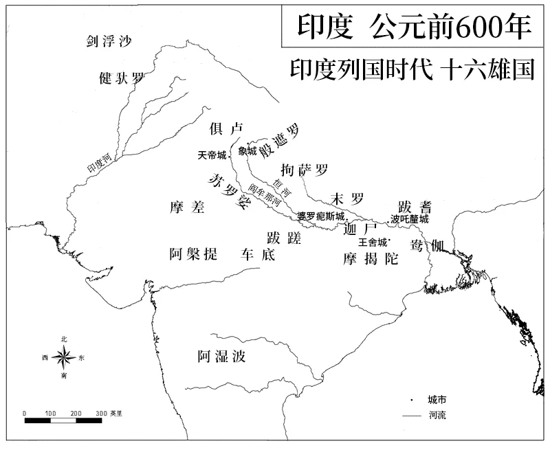
Illustrative context for ancient India’s territorial states; metadata is in Chinese.
Credit: Vikarna · CC BY-SA 4.0 · sourceResized and converted to WebP; uncropped.
Map study
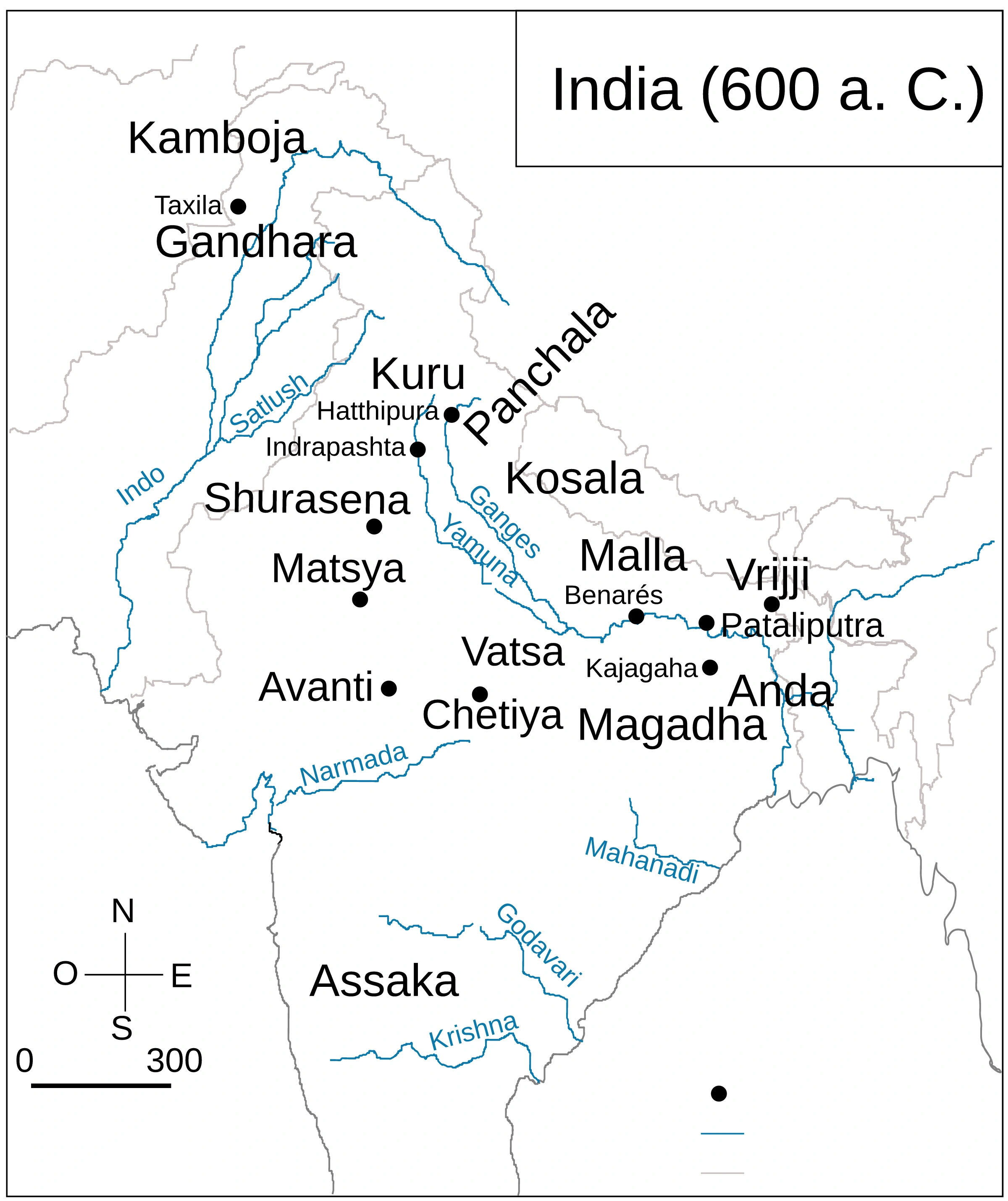
Sixteen Mahajanapadas: approximate ancient regional locations; compare Magadha and the Gangetic cluster with the northwest.
- Read the source date and legend; distinguish territory, influence and geographic location.
- Historical boundaries and reference memberships are not live political or operational data.
Credit: Rowanwindwhistler; Ski · CC BY-SA 4.0 · sourceConverted to WebP on an opaque white background; proportionally resized without cropping. Original cartography and legend retained.
1. From Vedic communities to territorial states
The term janapada literally suggests the foothold or settlement of a jana, a people or community. During the later Vedic period, political organisation increasingly acquired a territorial character. Some janapadas expanded into larger and more powerful Mahajanapadas, or great territorial states. Their emergence was a gradual process rather than a single event, and the familiar sixteen-state list should not be treated as a permanent political map.
By approximately the sixth century BCE, the middle Gangetic basin had become a major centre of settlement and political competition. Agricultural expansion, access to fertile alluvial soils, population growth and the mobilisation of surplus supported larger settlements, officials and armies. Iron tools helped agricultural development in some regions, but iron alone cannot explain state formation: labour organisation, water availability, exchange networks and political institutions also mattered.
This transformation formed part of the second urbanisation of the subcontinent. Unlike the earlier Harappan urban tradition, its principal centres included towns of the Gangetic plain and connected regions. Buddhism and Jainism developed within this changing society. Although studied after the Vedic period, the Mahajanapadas therefore belong to the transition into early historic India, not simply to an unchanged Vedic social order.
- Political shift: lineage-based authority increasingly gave way to control over territory and resources.
- Economic shift: expanding agriculture and exchange supported towns and specialised occupations.
- Religious shift: shramana traditions questioned ritual authority and offered alternative paths to liberation.
Timeline
Approximately 1000–600 BCE
Later Vedic developments contributed to settled territorial polities and expanding agriculture.
Sixth century BCE
Mahajanapadas, expanding towns and new shramana movements became prominent.
Sixth–fifth centuries BCE
Bimbisara and Ajatashatru expanded Magadha through conquest and diplomacy.
Fifth–fourth centuries BCE
Pataliputra rose in importance; Shishunaga and Nanda rule extended Magadhan power.
Approximately 321 BCE
Chandragupta Maurya established Mauryan rule, building on the Magadhan political base.
2. Sources and the geographical distribution of the sixteen states
The Anguttara Nikaya is the standard Buddhist source for the sixteen Mahajanapadas. Jain texts, including the Bhagavati Sutra, preserve a different political geography. These traditions were transmitted and compiled over time; their lists are not exact contemporary administrative surveys. Archaeological evidence from settlements, fortifications, pottery and coins helps test and supplement textual descriptions.
For map-based questions, group the states geographically rather than memorising isolated names. Their boundaries shifted, and modern state labels are only approximate. Several capitals are securely associated with particular states, while others have variant names or uncertain identifications. Kamboja’s precise territorial extent and capital are especially unsuitable for rigid modern mapping.
- Eastern Gangetic region: Anga, around Bhagalpur and Munger in Bihar, had Champa as its capital; Magadha, in southern Bihar, was centred initially on Rajagriha.
- Middle Gangetic region: Kashi centred on Varanasi; Kosala occupied much of Awadh, with Shravasti an important capital; Vajji was a confederacy north of the Ganga, associated with Vaishali.
- Malla had centres at Kushinara and Pava in present-day eastern Uttar Pradesh. Chedi lay around Bundelkhand, with Suktimati traditionally identified as its capital.
- Vatsa occupied the region around modern Prayagraj, with Kaushambi as its capital. Kuru was associated with the Delhi–Meerut region and Indraprastha; Panchala lay farther east, with Ahichchhatra and Kampilya as northern and southern centres.
- Matsya lay in eastern Rajasthan, associated with Viratanagara; Surasena centred on Mathura.
- Avanti covered the Malwa region and adjoining areas, with Ujjayini and Mahishmati as its major northern and southern centres.
- Assaka or Ashmaka lay in the Godavari valley; its capital appears as Potana or Potali, whose precise identification is debated.
- Gandhara occupied the north-west, including the Peshawar–Taxila region, with Taxila a major centre. Kamboja lay farther north-west, broadly in areas adjoining Afghanistan.
A simplified model of territorial state formation
- 1. Expansion of settled agriculture
- 2. Greater surplus and occupational specialisation
- 3. Growth of exchange networks and towns
- 4. Mobilisation of revenue and military resources
- 5. Competition, alliances and territorial conquest
- 6. Consolidation of larger states, especially Magadha
3. Monarchies and gana-sanghas
The Mahajanapadas did not share a uniform constitution. In monarchies such as Magadha and Kosala, kingship was generally hereditary, although succession disputes were common. Rulers maintained armies, collected resources and worked through officials. Fortified capitals served political, military and economic functions. Older assemblies associated with Vedic communities lost much of their earlier significance in several expanding kingdoms.
Gana-sanghas were political communities in which authority was exercised collectively by members of ruling clans. Vajji was a confederacy that included the Licchavis; Malla also possessed a non-monarchical organisation. Literary traditions describe deliberations in assemblies and meeting halls, often called santhagaras. Chiefs could bear the title raja even where no single hereditary monarch monopolised authority.
Calling these states republics is convenient but requires qualification. They were generally oligarchies, not democracies based on universal participation. Political rights largely belonged to a restricted aristocratic group; women, labourers and dependent populations did not enjoy equal membership. Also distinguish the sixteen Mahajanapadas from smaller clan polities: the Shakyas, to whom the Buddha belonged, do not appear as a separate Mahajanapada in the standard sixteen-state list.
- Prelims distinction: a ruler’s title alone does not establish whether a polity was monarchical.
- Vajji denotes the wider confederacy; Licchavi denotes one of its constituent groups.
- Political form and economic development were separate variables: non-monarchical states could also possess important settlements and trade connections.
| State | Principal centre | Political or geographical distinction |
|---|---|---|
| Magadha | Rajagriha; later Pataliputra | Monarchy in southern Bihar; nucleus of later empires |
| Vajji | Vaishali | Confederacy north of the Ganga, including the Licchavis |
| Malla | Kushinara and Pava | Gana-sangha with two major centres |
| Avanti | Ujjayini and Mahishmati | Important western monarchy with northern and southern divisions |
| Assaka | Potana or Potali | Godavari valley state, south of the Vindhyas |
| Gandhara | Taxila | North-western centre linked to transregional exchange |
4. Economy, society and urbanisation
Agriculture remained the principal economic base. Cultivators produced surpluses that ruling authorities appropriated through levies, tribute and other obligations. Terms such as bali, bhaga and shulka occur in early textual traditions, but their meaning and operation varied. Avoid assuming that every Mahajanapada possessed an identical tax system or the fully elaborated administration described in later texts.
Urban centres such as Kaushambi, Rajagriha, Varanasi, Ujjayini and Taxila connected agricultural hinterlands with craft production and long-distance commerce. River routes, particularly the Ganga system, reduced transport costs. Northern and southern overland networks linked regions conventionally associated with the Uttarapatha and Dakshinapatha. Merchants, financiers and substantial householders became increasingly prominent; terms such as setthi and gahapati reflect these changing social roles.
Punch-marked coins, commonly of silver, appeared in early historic exchange, although their earliest chronology and regional development remain debated. Northern Black Polished Ware is an important archaeological marker of this wider period, especially in the Gangetic region. Neither coins nor pottery styles can, by themselves, identify a particular Mahajanapada. Varna distinctions coexisted with considerable social and occupational diversity, while Buddhist and Jain communities drew support from rulers, merchants and householders.
5. Why Magadha became dominant
Magadha combined favourable geography with sustained political action. Fertile lands supported agriculture, while access to the Ganga and its tributaries facilitated movement and exchange. Forests provided timber and elephants, and proximity to mineral-bearing regions offered potential access to iron resources. These were advantages rather than automatic causes: rival states also possessed productive land, towns and commercial connections.
Bimbisara of the Haryanka dynasty strengthened Magadha through conquest and matrimonial diplomacy. His annexation of Anga brought Champa and its eastern commercial connections under Magadhan control. Ajatashatru subsequently fought Kosala and the Vajji confederacy. Buddhist accounts associate the weakening of Vajji with both warfare and efforts to undermine its internal cohesion.
Rajagriha’s surrounding hills provided natural protection. Pataliputra later offered a strategically valuable position near major river routes; Udayin is traditionally credited with establishing the capital there. Under the Shishunagas, Avanti was absorbed, removing a major western rival. Nanda expansion further enlarged Magadhan power before the Mauryas inherited this political base. Thus, the Mahajanapada age explains the foundations of empire, without implying that imperial unification was inevitable.
- Remember the combination: agrarian resources, river communications, military capacity, diplomacy and effective leadership.
- Distinguish Magadha’s location south of the Ganga from Vajji’s core territory to its north.
- Treat exact regnal dates and colourful descriptions of ancient war machines cautiously because textual traditions differ.
Mahajanapadas: Territory, Political Forms and Magadha’s Rise
The supplied description identifies the subject as India’s age of competing states, making it relevant to the Mahajanapadas. These large territorial polities reflected a shift from lineage-centred communities towards more extensive political authority. Buddhist tradition enumerates sixteen Mahajanapadas, but this list should not be treated as a precise snapshot of sixteen equally powerful states with permanently fixed borders. Their emergence belongs to the early historic transition, rather than to the early Vedic setting.
Political organisation varied: monarchies coexisted with gana-sanghas, where authority rested with restricted ruling groups rather than a modern democratic electorate. Agricultural expansion, surplus mobilisation, settlements and exchange supported state formation and the wider process of urbanisation. Magadha’s ascent is best explained through interacting advantages, including its fertile riverine setting, communication routes, resource access and political consolidation—not iron alone. This image can support regional orientation, but metadata alone cannot establish its boundary accuracy, capital placements or chronological consistency; these require checking against reliable historical references.
- Prelims distinction: a Mahajanapada was a territorial polity, not its capital; distinguish Magadha from Rajagriha and Vatsa from Kaushambi.
- Political distinction: “republic” is conventional shorthand for gana-sanghas; it does not imply universal suffrage, social equality or modern representative institutions.
- Mains approach: connect agrarian change, trade and political competition with Buddhism and Jainism’s emergence, without assuming a single uniform causal sequence.
Real-world case studies
Rajgir: geography and political security
Ancient Rajagriha, identified with modern Rajgir in Bihar, occupied a valley enclosed by hills. Its landscape illustrates the defensive advantages sought by early capitals. Surviving stone fortifications are important archaeological remains, although their individual construction phases should not automatically be assigned to a particular ruler.
Vaishali: collective rule without universal democracy
Vaishali was a major centre of the Licchavis within the Vajji confederacy. Buddhist accounts emphasise regular assemblies and concord as strengths of the Vajjis. The example demonstrates an alternative to monarchy, but restricted clan membership makes comparison with modern electoral democracy misleading.
Previous year questions
No source-linked PYQ is available here yet. Use the practice questions below.
Practice questions
Practice MCQ 1
Consider the following pairs: 1. Vatsa — Kaushambi; 2. Surasena — Mathura; 3. Anga — Rajagriha. How many pairs are correctly matched?
- A. Only one
- B. Only two
- C. All three
- D. None
Practice MCQ 2
Which statement best describes the gana-sanghas of early historic India?
- A. They guaranteed equal political rights to all adult residents.
- B. They had no assemblies or recognised chiefs.
- C. Authority was generally shared among members of ruling clans.
- D. Every Mahajanapada followed this political system.
Practice MCQ 3
With reference to the Mahajanapadas, consider the following statements: 1. Assaka was associated with the Godavari valley. 2. Vajji’s core territory lay south of the Ganga. 3. The Anguttara Nikaya contains a list of sixteen Mahajanapadas. Which statements are correct?
- A. 1 and 2 only
- B. 2 and 3 only
- C. 1 and 3 only
- D. 1, 2 and 3
Mains practice · Explain the relationship between economic change and the emergence of the Mahajanapadas. Why did Magadha outperform its major rivals? Answer in 250 words.
- Introduce the transition from janapadas to larger territorial states.
- Connect agricultural surplus, towns, trade and resource mobilisation.
- Explain the coexistence of monarchies and oligarchic gana-sanghas.
- Discuss Magadha’s fertile land, river routes and access to forest and mineral resources.
- Assess conquest, matrimonial alliances and the contributions of successive rulers.
- Conclude that geography enabled expansion, but political choices shaped the outcome.
Further reading
- NCERT, Themes in Indian History, Part I, Chapter 2: Kings, Farmers and Towns.
- NCERT, Our Pasts–I, Chapter: Kingdoms, Kings and an Early Republic.
- R. S. Sharma, India’s Ancient Past.
- Upinder Singh, A History of Ancient and Early Medieval India.
- Archaeological Survey of India: official information on Rajgir, Vaishali and other early historic sites.
- https://commons.wikimedia.org/wiki/File:Ancient_india-zh.png
Preparing for UPSC Civil Services? Get classroom teaching, answer-writing evaluation and mentorship at Pragnya IAS Academy, Ashok Nagar — see why aspirants choose us for IAS coaching in Hyderabad.