
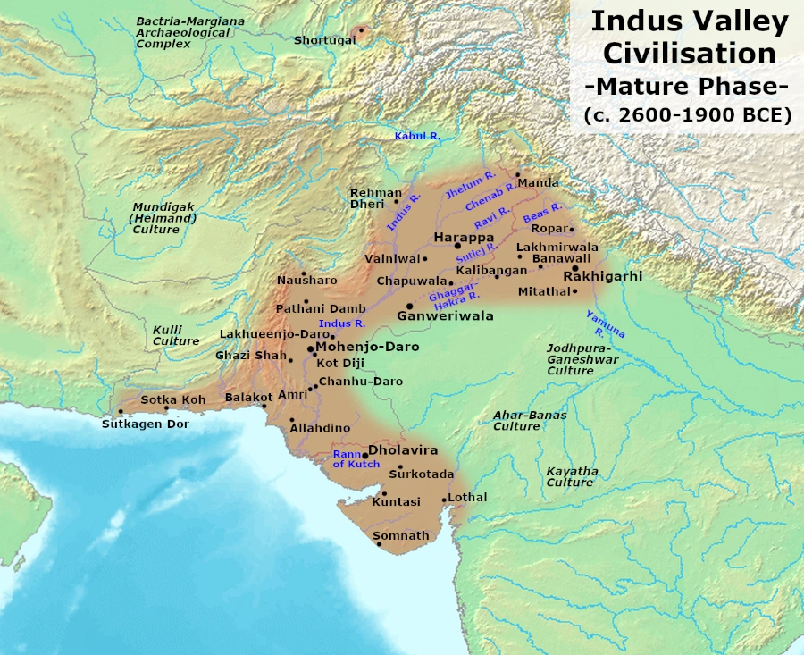
Map study
Mature Harappan civilisation, c. 2600–1900 BCE: settlement distribution, not the territory of a single empire.
- Read the source date and legend before interpreting territorial extent.
- Compare core regions, neighbouring powers and geographic barriers; historical borders and influence are approximate and changed over time.
Credit: Avantiputra7 · CC BY-SA 3.0 · sourceConverted to WebP on an opaque white background; proportionally resized without cropping. Original cartography and legend retained.
1. Urbanisation and the logic of settlement planning
Harappan urbanism emerged from a long regional history of farming villages, craft production and exchange. During the Mature Harappan phase, large settlements became centres of administration, production and redistribution within networks extending across northwestern South Asia. Planned spaces, recurring building proportions and standardised weights suggest shared conventions and considerable coordination. These features do not, however, prove that every city belonged to a single centrally administered empire.
Many settlements had streets running broadly north–south and east–west, often intersecting at approximately right angles. Larger roads connected neighbourhoods, while narrower lanes provided access to houses. This is commonly described as a grid pattern. The description is useful but should not be treated as a perfectly uniform geometric plan: street alignments, plot boundaries and rebuilding histories show variations. Archaeology reveals planned elements alongside incremental growth.
Location influenced urban form. Riverine plains offered agricultural hinterlands and transport opportunities, while Gujarat connected inland settlements with coastal exchange networks. Platforms, embankments and substantial walls sometimes helped manage environmental risks, including flooding. Dholavira, located on Khadir island in the Rann of Kachchh, faced a different challenge: securing seasonal runoff in a water-stressed landscape. Harappan planning therefore combined common practices with ecological adaptation.
- Exam distinction: urban planning includes streets, neighbourhoods, water systems, public structures and production spaces, not merely drainage.
- Avoid universal claims such as every Harappan settlement had a perfect grid, a citadel or underground sewers.
Timeline
c. 3300–2600 BCE
Early Harappan regional settlements developed craft networks, enclosure systems and increasingly organised layouts.
c. 2600–1900 BCE
Mature Harappan urbanism flourished, with major cities, standardised construction practices and elaborate water infrastructure.
After c. 1900 BCE
Major urban centres declined or changed, accompanied by regionalisation and shifts in settlement distribution.
2. Settlement sectors, walls and building technology
Textbook accounts often distinguish an elevated western citadel from a more extensive lower town to the east, particularly at Mohenjo-daro. Elevated sectors contained substantial structures and restricted or monumental spaces. Yet citadel is an archaeological label, not proof of a royal fortress. Similarly, lower town does not mean that only poorer inhabitants lived there. Harappa had several mounded and enclosed sectors, while Dholavira had a distinctive arrangement conventionally described through a citadel, middle town and lower town.
Walls could demarcate sectors, regulate movement, retain raised ground or offer protection. Their precise purposes must be assessed site by site rather than attributed exclusively to warfare. Gateways and passages reveal the organisation of access within settlements. Repeated construction on elevated platforms also indicates efforts to maintain usable space through successive phases of occupation and environmental change.
Mud bricks were widely employed, while fired bricks were especially useful where resistance to water and wear mattered. A recurring brick ratio of approximately 1:2:4 facilitated bonding and modular construction. It is incorrect to assume that all buildings were made of burnt brick: material choices depended partly on availability. Dholavira is particularly notable for extensive stone construction. Houses commonly contained rooms arranged around a courtyard; larger examples had bathing areas and sometimes wells or staircases. Differences in house size and facilities suggest social differentiation, although they cannot be translated directly into known caste or class categories.
- Common pattern does not equal universal template: Dholavira is a major qualification to the simple two-part city model.
- No structure has been universally accepted as an identifiable Harappan royal palace.
Typical wastewater pathway where connected drainage existed
- 1. Water used at a household bathing platform
- 2. Sloping surface directs wastewater to an outlet
- 3. Small household drain carries wastewater outward
- 4. Settling or collection arrangement intercepts some solids
- 5. Street drain conveys wastewater towards further disposal
3. Water supply, bathing and drainage
Water infrastructure provides some of the strongest evidence for organised urban life. Mohenjo-daro had numerous brick-lined wells, including wells associated with residential buildings. Bathing platforms were often paved and sloped to guide wastewater towards outlets. Household drains could discharge into street drains, demonstrating a physical connection between private dwellings and neighbourhood infrastructure. Such arrangements required coordination beyond individual building plots.
Street drains were frequently lined with bricks and covered with removable slabs or bricks. Covers and access points made cleaning possible, while settling arrangements could intercept solid material before wastewater entered larger channels. Nevertheless, the surviving evidence does not justify calling the system a modern sewerage network. Not every house had identical facilities, and wastewater disposal could also involve soakage jars or pits. Provision varied between cities and within neighbourhoods.
Mohenjo-daro’s Great Bath was a carefully constructed tank, approximately 12 metres long, 7 metres wide and 2.4 metres deep. Steps provided access, and brickwork, mortar and bituminous waterproofing helped retain water. Associated rooms and hydraulic arrangements suggest a special function; collective or ritual bathing is a common interpretation, not a deciphered historical fact. At Dholavira, channels, reservoirs and works associated with the seasonal Mansar and Manhar streams demonstrate water harvesting adapted to limited and seasonal rainfall.
- Great Bath: Mohenjo-daro, not Harappa or Dholavira.
- Water harvesting through an elaborate reservoir system: especially associated with Dholavira.
- Drainage indicates organised wastewater management, not proof of modern germ theory or universal sanitation.
| Site | Present location | Key planning association |
|---|---|---|
| Mohenjo-daro | Sindh, Pakistan | Great Bath, numerous wells and extensive drainage |
| Harappa | Punjab, Pakistan | Multiple mounded sectors, enclosure walls and substantial platforms |
| Dholavira | Gujarat, India | Stone architecture, differentiated sectors and reservoirs |
| Kalibangan | Rajasthan, India | Fortified sectors and planned streets |
| Lothal | Gujarat, India | Craft production and a large basin commonly interpreted as a dockyard |
4. Public spaces, crafts and the organisation of urban life
Harappan cities supported specialised crafts such as bead-making, shell-working, metallurgy, pottery and seal manufacture. Workshops, furnaces, tools and production waste help archaeologists identify activity areas. Their distribution indicates that towns were productive landscapes as well as residential settlements. Some crafts concentrated in particular neighbourhoods or settlements, but evidence does not support a rigid modern-style industrial zoning system across the civilisation.
Large buildings and platforms have often been interpreted as facilities serving collective purposes. However, familiar labels require caution. Structures traditionally called granaries at Harappa and Mohenjo-daro have debated functions; their identification cannot be treated as conclusively established by stored grain. At Lothal, a large brick-lined basin is widely interpreted as a dockyard, although alternative interpretations exist. Its significance should be explained alongside evidence for coastal exchange and craft production.
Shared building conventions, infrastructure maintenance and controlled access imply institutions capable of mobilising labour and coordinating decisions. Whether these were monarchies, councils, mercantile groups or other arrangements remains unresolved. Unlike Egypt or Mesopotamia, Harappan archaeology has not yielded securely identified royal tombs or unequivocal monumental temples. This contrast is significant, but absence of identified monuments does not prove an egalitarian society or the absence of political and religious authority.
- Use evidence-based wording: traditionally identified granary, basin interpreted as a dockyard, and possible ritual bathing.
- Standardisation supports organised coordination, but does not by itself establish a particular form of government.
5. Regional variation, transformation and examination relevance
Site comparisons are more reliable than memorising a single ideal city. Mohenjo-daro illustrates extensive wells, drainage and the Great Bath. Kalibangan in Rajasthan had distinct fortified sectors and planned streets; its famous excavated ploughed field belongs to the earlier settlement phase and is evidence of agricultural practices rather than urban sanitation. Dholavira combines stone architecture, multiple internal divisions, reservoirs and large open spaces. Lothal links settlement planning with craft production and exchange.
After approximately 1900 BCE, many major cities contracted or were abandoned, while settlement patterns and material traditions changed regionally. This was not an instantaneous disappearance of all Harappan communities. Environmental changes, altered river regimes, transformations in exchange and shifts in population distribution contributed in different places; no single explanation adequately accounts for every region. Reduced urban scale did not mean the complete loss of inherited technologies.
For Prelims, revise site–feature associations, building materials, hydraulic structures and the limits of archaeological interpretation. For Mains, connect urban planning with environmental adaptation, collective infrastructure and social organisation. Comparisons with contemporary urban policy may be illustrative, but calling Harappan cities smart cities or asserting direct continuity with modern municipal institutions would be anachronistic.
- Core analytical theme: shared planning principles coexisted with regional diversity.
- Major interpretive limitation: the undeciphered script prevents direct reconstruction of municipal rules and administrative offices.
Real-world case studies
Dholavira: planning for seasonal water availability
Dholavira, inscribed on the UNESCO World Heritage List in 2021, integrated reservoirs and water channels into its settlement design. Capturing seasonal flows and storing water illustrate environmental adaptation rather than dependence on a single perennial river.
Mohenjo-daro: linking households and shared infrastructure
Wells, bathing platforms and street drains demonstrate connections between domestic life and collective infrastructure. Their construction and maintenance imply organised cooperation, although the authority responsible remains unknown.
Previous year questions
UPSC Prelims 2021
Which ancient town is well known for an elaborate system of water harvesting and management involving dams and channels directing water into connected reservoirs?
- A. Dholavira
- B. Kalibangan
- C. Rakhigarhi
- D. Ropar
Practice questions
Practice MCQ 1
Consider the following statements: 1. Every Harappan city followed an identical two-part layout. 2. Stone was extensively used at Dholavira. 3. The Great Bath was discovered at Mohenjo-daro. Which statements are correct?
- A. 1 and 2 only
- B. 2 and 3 only
- C. 1 and 3 only
- D. 1, 2 and 3
Practice MCQ 2
Which inference is best supported by the presence of household drains connected to street drains?
- A. Harappans understood modern germ theory.
- B. All houses enjoyed identical sanitation facilities.
- C. Infrastructure required coordination beyond individual households.
- D. An elected municipal council administered every city.
Practice MCQ 3
With reference to Harappan construction, consider the following statements: 1. A brick proportion of approximately 1:2:4 was common during the mature phase. 2. Mud bricks were absent from major settlements. 3. The functions of structures traditionally called granaries remain debated. Which statements are correct?
- A. 1 only
- B. 2 and 3 only
- C. 1 and 3 only
- D. 1, 2 and 3
Mains practice · Harappan urban planning reflected both shared conventions and adaptation to local environments. Discuss with examples. Answer in 250 words.
- Introduce Mature Harappan urbanism and its chronology.
- Explain organised streets, brick proportions, household layouts and drainage.
- Contrast Mohenjo-daro’s wells with Dholavira’s reservoir-based water management.
- Highlight variations in settlement sectors and building materials.
- Distinguish evidence of coordination from uncertain claims about political institutions.
- Conclude that Harappan urbanism was organised but not architecturally uniform.
Further reading
- NCERT, Themes in Indian History, Part I: Bricks, Beads and Bones.
- NCERT, Our Pasts–I: In the Earliest Cities.
- UNESCO World Heritage Centre: Dholavira, a Harappan City.
- Archaeological Survey of India: Dholavira excavation and site publications.
- Upinder Singh, A History of Ancient and Early Medieval India.
Preparing for UPSC Civil Services? Get classroom teaching, answer-writing evaluation and mentorship at Pragnya IAS Academy, Ashok Nagar — see why aspirants choose us for IAS coaching in Hyderabad.