
El Niño Outlook to March 2027: ENSO Dynamics and India’s Climate Risks
Revise the static topic: UPSC Geography notes · UPSC Disaster Management notes
In short: According to the supplied Indian Express report, NOAA forecasts that the intensifying El Niño could remain strong to very strong through the first quarter of 2027. For India, this warrants preparedness for rainfall variability, warmer conditions and agricultural stress, but neither a deficient monsoon nor a record-breaking El Niño is a confirmed outcome.
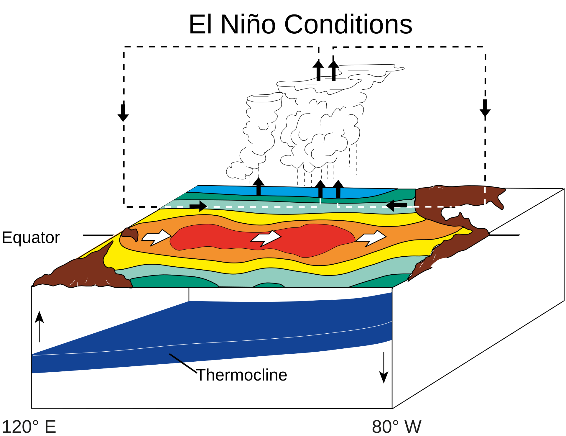
El Niño schematic showing warmer central and eastern equatorial Pacific waters, reduced cold-water upwelling off South America and shifted atmospheric circulation—not a forecast of the event’s strength or duration.
Image: Fred the Oyster · Public domain
Why in news
The report attributes to NOAA an outlook for El Niño persistence until March 2027 and around a 60% chance of reaching a historically exceptional intensity during the October–December and November–January periods. The central policy issue is how to translate a probabilistic global climate outlook into location-specific preparedness.
Around 60%
Reported probability of historically exceptional intensity
+2.5°C or more
Index threshold cited for the exceptional-event outlook
March 2027
Reported persistence horizon
1950
Starting year of the historical comparison cited
Background
The El Niño–Southern Oscillation, or ENSO, is a naturally occurring coupled ocean–atmosphere phenomenon in the tropical Pacific. Its phases are El Niño, La Niña and neutral. Under neutral conditions, easterly trade winds help maintain warmer surface waters in the western Pacific and promote the upwelling of colder water in the eastern Pacific. Changes in these winds, ocean temperatures and tropical convection modify the Walker circulation and influence weather in distant regions through atmospheric teleconnections. ENSO is an important driver of Indian climate variability, but it operates alongside the Indian Ocean state, land–ocean temperature contrasts and shorter-period monsoon fluctuations.
What the outlook says—and what it does not
The supplied report attributes to NOAA a forecast that El Niño will remain strong to very strong during the first quarter of 2027. It also quotes around a 60% chance of an event reaching the exceptional intensity threshold cited for the October–December and November–January periods.
Observed Pacific warming, a forecast of further intensification and an eventual historical ranking are different claims. The headline description of the event as the strongest since 1950 should therefore be read as a projected possibility, not an established final outcome. A record comparison requires the same index, geographical region, averaging period and reference baseline.
An institutional correction is essential: NOAA is a United States scientific agency, not a United Nations organisation. The World Meteorological Organization is a specialised agency of the United Nations.
- A probability attached to Pacific El Niño intensity is not a probability of drought in India.
- Persistence until March 2027 does not establish the ENSO phase during India’s subsequent southwest monsoon.
- An ENSO temperature anomaly measures departure from a reference condition; it is not the absolute temperature of the ocean.
Infographic
Pacific mechanism
Warming, weaker trade winds and shifted convection interact.
Forecast discipline
Projected intensity is not an observed historical record.
Indian modifiers
Ocean conditions, season and regional weather shape outcomes.
Sectoral exposure
Crops, water supplies and heat-sensitive populations need attention.
Adaptive action
Update local measures as forecasts and observations evolve.
AI-assisted infographic by Pragnya IAS Academy, based on the cited sources.
ENSO dynamics: how Pacific warming affects distant weather
During El Niño, weakened easterly trade winds allow warm surface waters to extend eastwards across the equatorial Pacific. Reduced upwelling and changes in the thermocline help sustain warming in the central and eastern Pacific. Tropical convection shifts, altering the Walker circulation and redistributing regions of rising and sinking air.
This interaction is reinforced by the Bjerknes feedback: changes in winds affect ocean temperatures, while changes in ocean temperatures further affect winds. The resulting atmospheric teleconnections can alter rainfall and temperature far beyond the Pacific.
The report refers to the Relative Ocean Niño Index, or RONI. Unlike a simple regional sea-surface temperature anomaly, a relative index accounts for broader tropical ocean warming. Operational diagnosis should consider the index methodology, persistence and ocean–atmosphere coupling rather than treating a single warm reading as sufficient.
- El Niño is the warm phase of ENSO, while La Niña is its cool phase.
- ENSO-neutral does not mean weather is necessarily normal or free from extremes.
- Local warming in one part of the Pacific is not interchangeable with the averaged Niño 3.4 index.
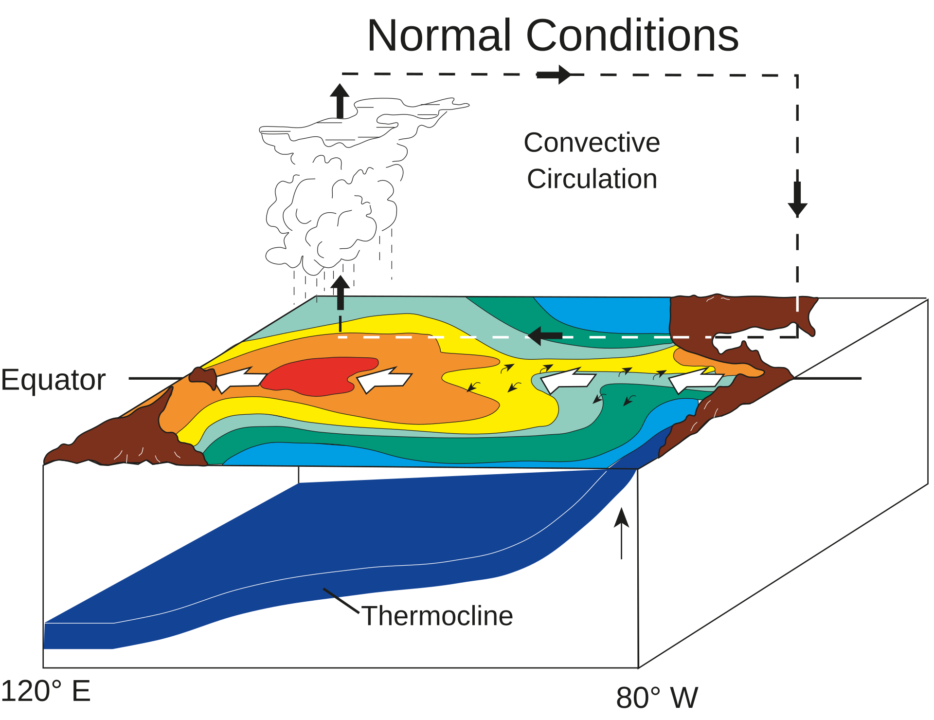
Neutral ENSO schematic for comparison: equatorial winds push warm surface water westward, while cold water rises off South America. Changes to this ocean–atmosphere pattern can influence weather far beyond the Pacific.
Image: Fred the Oyster , Czech translation Jirka Dl · Public domain
Implications for Indian rainfall and temperature
El Niño is often associated with weaker Indian southwest monsoon rainfall because changes in tropical circulation can suppress convection over the monsoon region. This is a statistical relationship, not a deterministic rule: El Niño does not invariably produce an all-India drought, and a national seasonal total can conceal major regional and temporal differences.
The Indian Ocean Dipole, intraseasonal oscillations, monsoon depressions and regional circulation can modify the ENSO influence. The northeast monsoon over southeastern peninsular India has a different ENSO relationship and can receive enhanced rainfall during some El Niño events. Hence, the proposition that El Niño uniformly reduces rainfall across India is incorrect.
El Niño can contribute to warmer conditions, but Indian heat risk also depends on season, soil moisture, cloud cover, humidity and local circulation. Persistence into early 2027 warrants monitoring for late-winter and pre-monsoon risks; it does not independently establish the severity or location of future heatwaves.
- Separate southwest monsoon impacts from northeast monsoon impacts.
- Distinguish meteorological drought from agricultural and hydrological drought.
- Use updated IMD assessments for Indian rainfall and temperature decisions rather than extrapolating directly from a global ENSO headline.
Agriculture and disaster management: act on risk, not certainty
Rainfall deficits or prolonged dry spells can reduce soil moisture, delay sowing and increase irrigation demand. Excessively warm conditions during sensitive crop stages can affect yields; terminal heat is particularly relevant for wheat. However, an ENSO forecast alone cannot establish crop losses, food inflation or reservoir shortages.
Preparedness should be multi-hazard. Even a season with below-normal total rainfall can contain damaging heavy-rainfall episodes and local floods. Dry vegetation and heat can increase fire-conducive conditions, but ignition sources, vegetation and land management also determine wildfire occurrence.
The appropriate response is phased anticipatory action: strengthen monitoring now, prepare contingency options and escalate interventions when regional forecasts and observed conditions justify them.
- Agriculture departments should align crop advisories with soil moisture, irrigation availability and district-level weather forecasts.
- Reservoir managers should balance drinking water, irrigation, ecological needs and flood-management requirements.
- Health and urban authorities should prepare heat action measures without declaring an inevitable heat emergency.
- Disaster authorities should retain flood, drought and fire preparedness rather than planning for only one hazard.
| Signal or claim | What it indicates | What it cannot establish |
|---|---|---|
| Observed Pacific warming | The present ocean state in the measured region and period | The final peak intensity or duration of the event |
| Around 60% exceptional-intensity probability | A conditional forecast for the specified Pacific index and periods | A 60% probability of drought or crop failure in India |
| Persistence until March 2027 | The reported forecast horizon for continued El Niño conditions | The ENSO state throughout the following southwest monsoon |
| El Niño–monsoon association | An increased risk of weaker southwest monsoon rainfall in some circumstances | Uniform rainfall deficits across every Indian region |
| A record-breaking intensity claim | A possibility requiring consistent historical comparison | An observed record before the relevant period is complete |
- 1. Equatorial Pacific trade winds weaken and ocean warming extends eastwards.
- 2. Changes in upwelling and the thermocline reinforce the warming.
- 3. Tropical convection and Walker circulation shift.
- 4. Atmospheric teleconnections alter the background conditions influencing Indian weather.
- 5. Indian Ocean conditions and regional weather systems modify the local outcome.
- 6. Updated forecasts and observed exposure guide sector-specific preparedness.
October 2026
The supplied report says WMO warned of exceptionally high Pacific temperature values.
November 2026
The supplied report attributes to NOAA an intensification outlook and around a 60% probability of historically exceptional intensity during the specified overlapping periods.
First quarter of 2027
The reported forecast indicates strong to very strong El Niño conditions; this is a forecast period, not an observed outcome.
Significance, challenges & way forward
Significance
- ENSO monitoring provides advance information for climate-sensitive decisions in agriculture, water management, health and energy.
- The outlook highlights the need to distinguish a predictable large-scale climate signal from less certain district-level impacts.
- Early preparation can reduce exposure even when the eventual event is weaker than forecast.
- Accurate interpretation prevents sensational record claims from becoming unsupported predictions of Indian drought or crop failure.
Challenges
- ENSO’s influence varies by season, region, event evolution and interactions with the Indian Ocean.
- Longer-range forecasts carry uncertainty, particularly when extrapolated beyond their stated horizon.
- Confusing absolute sea temperature, local anomalies and regional indices can distort assessments of event strength.
- Farmers and local administrations may receive broad climate warnings without actionable crop- or district-specific guidance.
- Seasonal rainfall totals can obscure damaging dry spells, short-duration extremes and unequal water availability.
- Unequal access to irrigation, cooling and financial protection increases vulnerability among small farmers and outdoor workers.
Way forward
- Base Indian operational decisions on regularly updated IMD forecasts, supported by credible international ENSO monitoring.
- Communicate the forecast variable, period, probability and uncertainty together, including the possibility that the projected outcome may not occur.
- Prepare district agricultural contingency plans covering crop choice, sowing decisions, irrigation scheduling and moisture conservation.
- Monitor reservoir storage, groundwater stress, soil moisture and crop conditions before imposing or relaxing water-use measures.
- Activate locally appropriate heat-health preparedness, including drinking water, shaded rest spaces and protection for outdoor workers.
- Maintain multi-hazard readiness and review action thresholds as forecasts and observations change.
Key terms
- ENSO
- A coupled tropical Pacific ocean–atmosphere phenomenon with warm, cool and neutral phases.
- El Niño
- The warm phase of ENSO, involving central and eastern equatorial Pacific warming and associated atmospheric changes.
- Walker circulation
- An east–west tropical atmospheric circulation involving rising air, upper-level flow, descending air and surface return winds.
- Bjerknes feedback
- A reinforcing interaction between equatorial Pacific winds, ocean temperature gradients and the thermocline.
- Thermocline
- The ocean layer across which temperature decreases rapidly with depth.
- Niño 3.4 region
- A central equatorial Pacific monitoring region used to assess ENSO-related sea-surface temperature anomalies.
- Relative Ocean Niño Index
- An ENSO index that assesses Niño 3.4 warming relative to broader tropical ocean temperature changes.
- Teleconnection
- A linkage through which climate variability in one region influences weather or climate in distant regions.
Link with static syllabus
Prelims practice MCQs
Q1. With reference to ENSO, consider the following statements: 1. El Niño involves changes in both the tropical Pacific Ocean and the atmosphere. 2. Weakened easterly trade winds can facilitate the eastward extension of warm surface waters. 3. ENSO-neutral conditions ensure the absence of extreme weather in India. Which of the statements given above are correct?
Q2. Consider the following statements about El Niño and India: 1. Every El Niño necessarily causes an all-India southwest monsoon drought. 2. Indian Ocean conditions can modify the influence of ENSO on Indian rainfall. 3. A season with deficient total rainfall may still experience local floods. Which of the statements given above are correct?
Q3. A forecast assigns around a 60% probability to an exceptionally intense El Niño during specified periods. Which of the following is the most appropriate inference?
Q4. Consider the following pairs: 1. NOAA — United States scientific agency 2. World Meteorological Organization — Specialised agency of the United Nations 3. RONI — Absolute sea-surface temperature at a single Pacific location Which of the pairs given above are correctly matched?
Mains practice questions
GS 3 · 15 marks · 250 words
El Niño is a risk multiplier, not a deterministic forecast of Indian drought. Explain its climatic influence and suggest a preparedness framework for India.
Frequently asked questions
Does the reported outlook confirm the strongest El Niño since 1950?
No. The supplied report quotes a probability of historically exceptional intensity; a final record claim requires completed observations and comparison using a consistent index and methodology.
Will El Niño continuing until March 2027 cause a poor Indian monsoon in 2027?
That cannot be concluded from this outlook. The subsequent monsoon requires updated ENSO projections, Indian Ocean assessments and regional rainfall forecasts.
Does El Niño reduce rainfall everywhere in India?
No. Its influence varies across regions and seasons, and the northeast monsoon can behave differently from the southwest monsoon.
Is NOAA a United Nations organisation?
No. NOAA is a United States scientific agency; the World Meteorological Organization is a specialised agency of the United Nations.
Sources
- Indian Express: ‘Intensifying’ El Niño to persist until March 2027; strongest ever since 1950, says NOAA
Analysis prepared by the Pragnya IAS Academy current-affairs desk with AI assistance from the cited reports. Verify figures with the original sources.
Turn current affairs into marks
Join Pragnya IAS Academy's mentorship for daily answer-writing evaluation on stories like this — classroom programmes from a trusted name in IAS coaching in Hyderabad.