
NVS-03 Reaches Geosynchronous Orbit: NavIC and India’s Navigation Autonomy
Revise the static topic: UPSC Science & Technology notes
In short: ISRO reported that NVS-03 reached its intended geosynchronous orbit after four successful orbit manoeuvres and that the satellite’s health was normal. The milestone advances NavIC’s replenishment, but dependable navigation services require successful commissioning, reliable satellite replacement and compatible user equipment—not merely a successful launch.
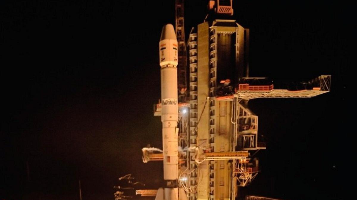
Photo from the source report: NVS-03 Reaches Geosynchronous Orbit: NavIC and India’s Navigation Autonomy
Image: The Hindu
Why in news
In its November 4, 2026 update, ISRO confirmed NVS-03’s arrival in geosynchronous orbit following its October 30 launch aboard GSLV. The achievement is significant after a valve malfunction prevented the intended orbit-raising operations of NVS-02 in 2025.
4
Successful orbit manoeuvres
6164 seconds
Cumulative LAM engine burn
1500 km
Coverage beyond Indian boundaries
5
Planned next-generation satellites
Background
Navigation with Indian Constellation, or NavIC, is the operational name of the Indian Regional Navigation Satellite System developed by ISRO. Unlike the global GPS constellation, NavIC is designed for regional coverage centred on India. Its architecture combines satellites in geostationary and inclined geosynchronous orbits with ground-based monitoring and control facilities and compatible user receivers. Navigation depends on precisely timed signals and accurate satellite-position information. NavIC provides a Standard Positioning Service for civilian users and a Restricted Service for authorised users.
What NVS-03 has achieved—and what remains to be established
GSLV-F18 launched NVS-03 from the Satish Dhawan Space Centre at Sriharikota, Andhra Pradesh, on October 30, 2026. The launch vehicle injected it into a transfer orbit reported as 170.3 km × 38080 km.
Following four orbit manoeuvres involving a cumulative Liquid Apogee Motor engine burn of 6164 seconds, ISRO reported that the satellite had reached its intended geosynchronous orbit and was in normal health.
This establishes successful launch injection and subsequent orbit raising. The supplied updates do not establish completion of navigation-payload commissioning or operational service entry; these should not be inferred from orbital arrival alone.
- NVS-03 is the third satellite in the planned series of five next-generation navigation satellites.
- Its purpose is to support continuity of navigation services provided by the IRNSS series.
- Its navigation payload operates in L1, L5 and S bands.
- It carries an indigenous atomic clock alongside procured clocks.
Infographic
Reliable access
Successful launch injection and onboard orbit raising.
Sustained constellation
Planned replenishment and continuous health monitoring.
Indigenous capability
Domestic clocks, electronics and receiver development.
Validated services
Payload commissioning and dependable ground operations.
User adoption
Compatible equipment and practical civilian applications.
Resilience
Interference safeguards and backup timing arrangements.
AI-assisted infographic by Pragnya IAS Academy, based on the cited sources.
NavIC architecture: space, ground and user segments
The space segment broadcasts navigation signals and timing information. NavIC’s combination of geostationary and inclined geosynchronous satellites supports regional coverage. A geosynchronous satellite has an orbital period equal to Earth’s sidereal rotation period; only a circular, equatorial, prograde geosynchronous orbit is geostationary.
The ground segment tracks satellites, monitors clocks and signals, determines orbits and uploads navigation information. The user segment consists of compatible receivers that process satellite signals to estimate position, velocity and time.
Atomic clocks provide the timing reference fundamental to satellite navigation. Adding L1 alongside L5 and S broadens the scope for receiver compatibility, but actual access still requires suitable antennas, chipsets and software.
- A transfer orbit is an intermediate orbit, not the final navigation-service orbit.
- NVS-03’s reported inclined geosynchronous orbit should not be described as geostationary.
- Service performance depends on the functioning of all segments, not the satellite payload alone.
Applications: positioning and timing as public infrastructure
NavIC can support road transport, fleet management, maritime navigation, fisheries, surveying and disaster-response logistics within its service region. Defence applications include navigation and coordination for authorised users.
Its timing function is also important: telecommunications, power systems and financial infrastructure depend on precise synchronisation. These are potential application domains for satellite-derived timing, not evidence that every such system already uses NavIC.
For safety-critical applications, signal availability alone is insufficient. Users also need appropriate accuracy, continuity, integrity monitoring and any applicable certification.
- Transport applications require compatible receivers and dependable service availability.
- Disaster response benefits from location-tagged information and coordinated movement of resources.
- Timing applications require robust synchronisation and independent backup arrangements.
Why launch reliability and replenishment are strategic issues
Navigation is a continuous service, whereas a launch is a discrete event. Ageing satellites, clock degradation or spacecraft failures can weaken service availability and satellite geometry unless replacements are introduced in time.
NVS-02 illustrates the distinction between launch success and mission success: after its January 29, 2025 launch, a valve malfunction prevented the intended orbit-raising operations. NVS-03’s successful orbital manoeuvres therefore represent an important additional milestone beyond launch-vehicle performance.
The reliability chain extends from launch injection through spacecraft propulsion and payload commissioning to ground operations and user receivers. Satellite replenishment must be planned as infrastructure maintenance rather than treated only as a succession of launches.
- Launch-vehicle reliability and spacecraft propulsion reliability require separate assessment.
- Replacement schedules should anticipate degradation rather than depend solely on failure-driven responses.
- Reported spacecraft health should be followed by payload validation and transparent service-status information.
NavIC versus GPS: autonomy without technological isolation
GPS provides global coverage, while NavIC’s stated coverage is India and a region extending 1500 km beyond its boundaries. NavIC is therefore not a like-for-like worldwide replacement for GPS.
Its strategic value lies in sovereign control over an essential positioning, navigation and timing capability. Indigenous clocks deepen technological capability, but NVS-03’s use of both indigenous and procured clocks also shows that localisation remains a continuing process.
Civilian receivers can use multiple constellations to improve availability and resilience while India retains an independently controlled regional capability. However, indigenous ownership does not itself prevent jamming or spoofing; these require additional technical and operational safeguards.
- Strategic autonomy means assured domestic capability, not mandatory exclusion of foreign systems.
- Interoperability can expand adoption while preserving sovereign service control.
- Regional coverage should not be confused with guaranteed performance in every operating environment.
| Dimension | NavIC | GPS |
|---|---|---|
| Control | Indian regional navigation system developed by ISRO | United States-controlled global navigation system |
| Coverage | India and approximately 1500 km beyond its boundaries | Global |
| Orbital architecture | Geostationary and inclined geosynchronous satellites | Medium Earth orbit satellites |
| Role for India | Sovereign regional positioning, navigation and timing capability | Access to a foreign-controlled global navigation service |
| User-equipment implication | Requires NavIC-compatible hardware and software | Requires GPS-compatible hardware and software |
| Relationship | Can complement GPS in multi-constellation receivers | Can be used alongside NavIC rather than treated as an exclusive alternative |
- 1. Launch vehicle injects the satellite into its transfer orbit.
- 2. Onboard propulsion raises and adjusts the orbit.
- 3. Ground teams verify spacecraft health, orbit and attitude.
- 4. Navigation payloads and clocks undergo testing and calibration.
- 5. The validated satellite is integrated into operational navigation services.
- 6. Continuous monitoring and planned replenishment sustain service availability.
January 29, 2025
NVS-02 was launched; a valve malfunction subsequently prevented its intended orbit-raising operations.
October 30, 2026
GSLV-F18 launched NVS-03 from Sriharikota and injected it into the intended transfer orbit.
November 4, 2026
ISRO reported completion of four orbit manoeuvres, arrival in geosynchronous orbit and normal satellite health.
Significance, challenges & way forward
Significance
- NVS-03 advances the replenishment effort needed to maintain continuity of India’s regional navigation capability.
- An independently controlled navigation system reduces strategic dependence on foreign-controlled positioning and timing services.
- The indigenous atomic clock strengthens domestic capability in a critical navigation technology.
- L1 transmission broadens opportunities for compatible mass-market receivers, subject to hardware and software support.
- Successful orbit raising reinforces confidence in mission execution after the NVS-02 setback.
Challenges
- Successful launch injection does not guarantee successful orbit raising, payload commissioning or sustained service delivery.
- Satellite ageing and clock failures require predictable replacement capacity and resilient constellation planning.
- Receiver availability, integration costs and software support can constrain civilian adoption.
- Jamming and spoofing remain threats even when the navigation constellation is domestically controlled.
- Regional coverage limits NavIC’s ability to serve as a standalone navigation solution for worldwide operations.
- The supplied reports do not establish NVS-03’s operational service entry or the current health of the full constellation.
Way forward
- Complete and communicate payload validation and commissioning before presenting NVS-03 as operational.
- Apply failure-analysis lessons to propulsion valves, subsystem testing and quality assurance across suppliers.
- Plan replenishment around satellite health, clock performance and service-continuity requirements.
- Strengthen domestic capabilities in atomic clocks, navigation electronics and compatible receiver chipsets.
- Encourage multi-constellation receivers while preserving independent access to NavIC services.
- Develop interference monitoring, resilient receivers and alternative timing arrangements for critical infrastructure.
- Publish accessible service-status information so users can assess availability and operational limitations.
Key terms
- NavIC
- Navigation with Indian Constellation, the operational name of India’s regional satellite navigation system.
- Positioning, navigation and timing
- Capabilities that establish location, support movement and provide precise time synchronisation.
- Geosynchronous orbit
- An orbit whose period equals Earth’s sidereal rotation period; it need not appear stationary from the ground.
- Geostationary orbit
- A circular, equatorial, prograde geosynchronous orbit in which a satellite appears fixed over the equator.
- Geosynchronous transfer orbit
- An intermediate elliptical orbit from which a satellite manoeuvres towards its intended geosynchronous orbit.
- Liquid Apogee Motor
- An onboard liquid-propellant engine used for orbit-raising and related orbital manoeuvres.
- Atomic clock
- A precision timekeeping device using an atomic transition as its frequency reference.
- Constellation replenishment
- The planned introduction of replacement satellites to sustain service capacity and continuity.
Link with static syllabus
Prelims practice MCQs
Q1. With reference to NVS-03, consider the following statements: Statement I: Its navigation payload operates in L1, L5 and S bands. Statement II: It carries an indigenous atomic clock alongside procured clocks. Statement III: Its arrival in geosynchronous orbit by itself proves completion of navigation-payload commissioning. Which of the statements given above are correct?
Q2. Consider the following statements regarding satellite orbits: Statement I: Every geostationary orbit is geosynchronous. Statement II: Every inclined geosynchronous satellite appears fixed over a point on the equator. Statement III: A geosynchronous transfer orbit is an intermediate orbit used before reaching the intended operational orbit. Which of the statements given above are correct?
Q3. With reference to NavIC and GPS, consider the following statements: Statement I: NavIC is designed for regional coverage centred on India. Statement II: GPS satellites primarily operate in geostationary orbits. Statement III: Compatible user receivers can use signals from more than one navigation constellation. Which of the statements given above are correct?
Q4. Which of the following best explains why atomic clocks are critical to satellite navigation?
Mains practice questions
GS 3 · 15 marks · 250 words
India’s navigation autonomy depends on more than launching indigenous satellites. Discuss with reference to NavIC, highlighting the importance of replenishment, reliability and user adoption.
Frequently asked questions
Has NVS-03 become fully operational?
The supplied reports confirm arrival in geosynchronous orbit and normal satellite health. They do not confirm completion of navigation-payload commissioning or operational service entry.
Is NavIC a global replacement for GPS?
No. NavIC is designed to cover India and a region extending 1500 km beyond its boundaries, while GPS provides global coverage; compatible receivers can use both.
Why is the L1 signal important?
L1 broadens the scope for integration with navigation receivers and chipsets. Access still depends on NavIC-compatible hardware and software, so support is not automatic for every existing device.
Why was NVS-03’s orbit raising particularly significant?
A valve malfunction prevented NVS-02’s intended orbit raising in 2025. NVS-03’s successful manoeuvres demonstrate completion of a critical mission stage beyond launch injection.
Sources
- The Hindu: NVS-03 reaches geosynchronous orbit; satellite in good health
- The Hindu: Back to back GSLV successes help ISRO win back some pride
- The Hindu: What is the debate on NavIC vs GPS | Explained
Analysis prepared by the Pragnya IAS Academy current-affairs desk with AI assistance from the cited reports. Verify figures with the original sources.
Turn current affairs into marks
Join Pragnya IAS Academy's mentorship for daily answer-writing evaluation on stories like this — classroom programmes from a trusted name in IAS coaching in Hyderabad.