
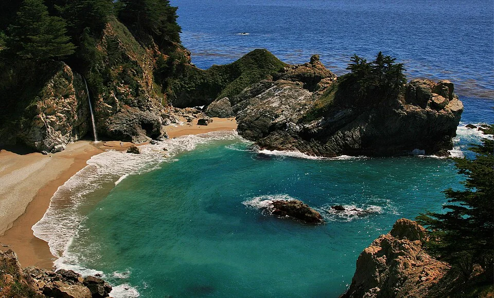
McWay Cove, California: a comparative example for studying coastal embayments.
Credit: Brocken Inaglory · CC BY-SA 3.0 · sourceResized and converted to WebP; uncropped.
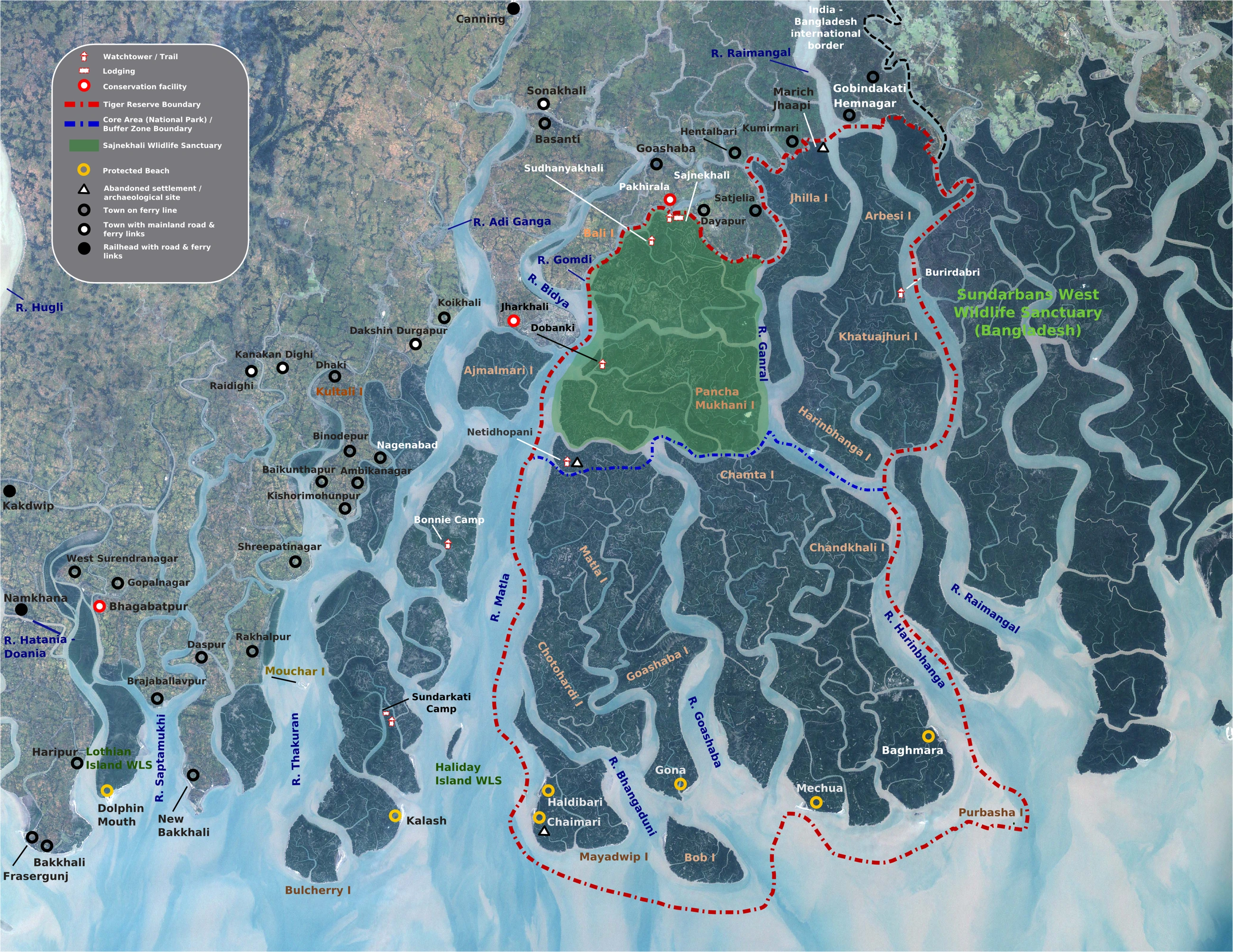
Map study
Sundarbans delta: relate distributaries and the Bay of Bengal coast to mangrove habitats. This geographic view is not a complete current protected-area boundary inventory.
- Read the source legend and reference date before interpreting the map.
- Use spatial patterns to support topic revision; verify current official boundaries, designations and warnings separately.
Credit: Pradiptaray · Public domain · sourceConverted to WebP on an opaque white background; proportionally resized without cropping. Original cartography and legend retained.
1. Controls and processes shaping coasts
A coast is the zone where terrestrial and marine processes interact, whereas the shoreline is the instantaneous boundary between land and water. Coastal morphology depends on wave energy, tidal range, currents, sediment availability, offshore slope, rock resistance and geological structure. Cyclones and storm surges can rapidly reshape landforms that normally evolve gradually. Consequently, a coastline should be understood as a dynamic system rather than a fixed boundary.
Most surface waves originate when wind transfers energy to water. As waves enter shallow water, interaction with the seabed slows them, shortens their wavelength and increases their steepness until they break. Wave refraction bends wave crests as different portions encounter different depths. Along an irregular coast, this generally concentrates energy on headlands and disperses it within bays, favouring headland erosion and sediment accumulation in sheltered recesses.
Marine erosion involves hydraulic action, abrasion and solution. Hydraulic action exploits cracks through water pressure and compressed air; abrasion occurs when sediment strikes or scrapes rock; solution affects soluble rocks such as limestone. Attrition is the wearing down of sediment particles through mutual collision, rather than direct erosion of a cliff. Salt weathering, rainfall, groundwater and mass movement also weaken cliffs before waves remove the debris.
- Tidal range influences the vertical extent of wave attack and the development of intertidal environments.
- Coastal change depends on the balance between sediment inputs, transfers, storage and losses within a sediment cell.
2. Erosional landforms: cliffs, platforms, caves and stacks
Sea cliffs are steep coastal faces produced where erosion and slope retreat affect resistant or unconsolidated materials. Concentrated wave attack may excavate a notch near the cliff base. Undercutting, weathering and instability lead to collapse and landward retreat. A gently sloping wave-cut platform may remain in front of the retreating cliff and can be exposed at low tide. Platforms are not necessarily produced by wave abrasion alone; weathering and other processes can contribute.
Where resistant and less resistant rocks alternate along a coast, differential erosion can produce projecting headlands and recessed bays. However, geological structure matters as much as hardness: joints, faults, bedding and the orientation of rock bands guide erosion. Headlands experience strong wave attack, while bays often provide lower-energy environments suitable for beaches.
Waves exploit weaknesses in a headland to enlarge cracks into caves. Continued erosion may produce an arch through the headland. Collapse of the arch roof can leave an isolated pillar called a stack; further erosion produces a low remnant or stump. This sequence is a useful model, not an inevitable history of every rocky coast. Blowholes develop where a cave connects to the surface through a shaft, allowing compressed air and water to escape.
- The Twelve Apostles in Victoria, Australia, are limestone stacks associated with coastal cliff retreat.
- Varkala in Kerala illustrates a cliff-backed shore; it should not be treated as evidence that all coastal cliffs share identical origins.
Idealised development of erosional features on a jointed headland
- 1. Waves exploit joints and fractures
- 2. Cracks enlarge into caves
- 3. Erosion creates an arch
- 4. Roof collapse isolates a stack
- 5. Further erosion reduces the stack to a stump
3. Sediment transport and depositional landforms
When waves approach a beach obliquely, swash carries sediment diagonally upslope, while backwash generally returns it downslope. Repetition creates longshore drift. Wave-generated longshore currents also transport sediment parallel to the shore. Transport direction and intensity can vary seasonally, particularly along monsoon-influenced Indian coasts. Beaches are accumulations of sand, gravel or other loose material supplied by rivers, eroding cliffs, offshore deposits and biological sources.
A spit is an elongated sediment ridge attached to land at one end and extending into open water. It commonly develops where a coastline changes direction or at an estuary mouth, allowing longshore transport to carry sediment beyond the shore. Its tip may become recurved under changing wave directions and currents. Sheltered water behind a spit may support mudflats or salt marshes. A baymouth bar extends across a bay, while a tombolo connects an island with the mainland or another island.
Barrier islands are elongated sandy islands separated from the mainland by lagoons, bays or marshes. They are distinct from spits because they are not attached to the mainland. Lagoons are shallow coastal water bodies partly separated from the sea by barriers; tidal inlets often maintain exchange. Offshore bars are submerged or partly emergent sediment ridges and should not automatically be equated with baymouth barriers.
- Mudflats develop where fine sediment settles in sheltered, low-energy intertidal settings.
- Coastal dunes form when wind transports dry beach sand inland and vegetation or obstacles trap it.
| Pair | Distinction | Key process |
|---|---|---|
| Spit and tombolo | Spit has one land-attached end; tombolo connects an island to another landmass | Sediment transport and deposition |
| Ria and fjord | Drowned river valley versus drowned glacial trough | Relative sea-level rise |
| Lagoon and estuary | Barrier-separated coastal water body versus marine–freshwater mixing environment | Barrier formation versus river–marine interaction; categories may overlap |
| Stack and stump | Tall isolated rock pillar versus low eroded remnant | Continued marine erosion |
| Beach and wave-cut platform | Loose sediment accumulation versus erosional rock surface | Deposition versus cliff retreat and erosion |
4. Sea-level change and classification of coasts
An emergent coast develops where land rises relative to sea level or sea level falls relative to land. Raised beaches and uplifted marine terraces can indicate former shoreline positions. A submergent coast develops when relative sea level rises because of ocean-level rise, land subsidence or both. Eustatic change concerns ocean-level change, while tectonic and isostatic movements affect land elevation. Present coastlines commonly preserve evidence of several episodes rather than one simple event.
Rias are drowned river valleys, usually branching and irregular in plan. Fjords are drowned glacial troughs, typically deep, steep-sided and U-shaped, sometimes with a shallower sill near their mouth. Norway provides classic fjord examples. A Dalmatian coast contains elongated islands and channels aligned broadly parallel to the mainland, reflecting submergence of a structurally controlled ridge-and-valley landscape, as along Croatia’s Adriatic coast.
An estuary is a coastal water body with marine exchange and freshwater input, whereas a delta is a sediment-built accumulation at a river mouth. Delta formation depends on sediment supply relative to redistribution by waves and tides, together with available accommodation space. Neither strong tides nor a particular coastal setting alone determines whether a delta forms. Estuarine and deltaic environments can occur together within complex river-mouth systems.
- The Narmada and Tapi have estuarine mouths; the Mahanadi, Godavari, Krishna and Kaveri have prominent deltaic systems.
- Emergent and submergent are useful interpretive categories, not permanent labels for entire national coastlines.
5. Biogenic coasts, Indian examples and human modification
Organisms also build and stabilise coastal landforms. Reef-building corals produce calcium-carbonate frameworks in suitable marine environments, generally warm, clear, sunlit water. Fringing reefs lie close to shore, barrier reefs are separated from land by a lagoon, and atolls form ring-like reefs enclosing lagoons. Darwin’s subsidence model explains a classic progression from fringing reef to barrier reef and atoll, although actual reef histories also involve sea-level fluctuations and other geological controls.
Lakshadweep contains coral atolls, while reefs also occur around the Andaman and Nicobar Islands, Gulf of Mannar and Gulf of Kachchh. Mangroves occupy suitable tropical and subtropical intertidal settings, trapping sediment and reducing current and wave energy. The Sundarbans demonstrate the interaction of distributary channels, tides, sediment deposition and mangrove vegetation. Mangroves cannot, however, eliminate all cyclone or tsunami damage.
Dams, sand extraction, ports and coastal structures can alter sediment budgets. Groynes and breakwaters may accumulate sand on one side while increasing erosion elsewhere. Seawalls protect assets locally but may contribute to beach narrowing. Beach nourishment, dune restoration, mangrove conservation and setback planning can complement engineered protection. Under India’s Environment (Protection) Act, 1986, Coastal Regulation Zone notifications regulate coastal activities; hazard assessment must still account for local geomorphology, subsidence and changing sea level.
- The east coast has extensive deltaic and lagoonal stretches, but broad east–west contrasts have local exceptions.
- For map-based revision, locate Chilika, Pulicat, Vembanad, the Sundarbans, Lakshadweep and the Gulf of Mannar.
Coastal Coves: Erosion, Shelter and Sediment
The metadata identifies McWay Cove at Julia Pfeiffer Burns State Park in California, making it directly relevant to coastal landforms as a comparative example rather than Indian evidence. A cove is a relatively small, sheltered coastal indentation, often with a restricted entrance. Such embayments may develop where differences in rock resistance, joints or faults guide erosion. However, the place name alone cannot establish this cove’s geological origin, sediment composition or present coastal processes.
Coastal embayments help explain why erosion and deposition can coexist along the same shoreline. Wave refraction commonly concentrates wave energy around projecting headlands and spreads it within bays, encouraging relatively sheltered conditions where sediment may accumulate if supply is sufficient. This is a general tendency, not a universal rule: storms, tidal currents, offshore bathymetry and human interventions can alter sediment movement. For Indian comparisons, rocky stretches of the Konkan coast provide a useful setting for studying headland–bay relationships, while Odisha’s Chilika illustrates a distinct barrier-associated lagoon system. These comparisons clarify processes without implying identical origins.
- Distinguish form from origin: “cove” describes a coastal indentation; it does not by itself prove differential erosion or a particular rock structure.
- Do not confuse a cove with a lagoon: a lagoon is separated from the open sea by a barrier, often retaining restricted marine connections.
- For Mains, explain coastal change through sediment budgets and relative sea level; a location label or single photograph cannot establish erosion rates or long-term shoreline trends.
Real-world case studies
Chilika: maintaining a lagoon’s marine connection
Chilika in Odisha is a brackish coastal lagoon separated from the Bay of Bengal by a sandy barrier. Restricted marine exchange contributed to ecological deterioration. A new sea mouth opened in 2000 improved exchange and helped ecological recovery. Chilika was removed from the Ramsar Montreux Record in 2002, illustrating the importance of inlet dynamics, salinity and sediment management.
Puducherry: harbour structures and sediment interruption
Harbour breakwaters at Puducherry interrupted littoral sediment transport, contributing to accumulation south of the harbour and erosion along stretches to the north. Subsequent beach-restoration efforts illustrate why shoreline protection must address sediment movement across the wider coastal cell rather than treating each beach independently.
Previous year questions
No source-linked PYQ is available here yet. Use the practice questions below.
Practice questions
Practice MCQ 1
Consider the following statements: 1. Wave refraction generally concentrates energy on headlands. 2. Attrition describes the wearing down of sediment particles through mutual collision. 3. Every wave-cut platform remains permanently above high-tide level. Which statements are correct?
- A. 1 and 2 only
- B. 2 and 3 only
- C. 1 and 3 only
- D. 1, 2 and 3
Practice MCQ 2
Which coastal feature is correctly matched with its description?
- A. Ria — Drowned glacial trough
- B. Tombolo — Sediment accumulation connecting an island to another landmass
- C. Spit — An isolated pillar of resistant rock
- D. Fjord — A lagoon enclosed by coral reefs
Practice MCQ 3
A groyne interrupts a coast’s dominant longshore sediment transport. Other conditions remaining unchanged, which outcome is most likely?
- A. Sediment accumulation updrift and possible erosion downdrift
- B. Equal sediment accumulation on both sides
- C. Immediate conversion of the beach into a wave-cut platform
- D. Permanent cessation of wave refraction
Mains practice · Explain how coastal landforms reflect interactions among marine processes, sediment budgets and relative sea-level change. Discuss the implications for coastal protection in India. Answer in 250 words.
- Introduce coasts as dynamic interfaces rather than fixed boundaries.
- Link refraction and erosion to headlands, cliffs, caves and stacks.
- Explain longshore transport, beaches, spits, barriers and lagoons.
- Distinguish relative emergence and submergence using terraces, rias and fjords.
- Use Chilika and Puducherry to illustrate inlet management and sediment interruption.
- Recommend sediment-cell planning, ecosystem restoration, setbacks and context-specific engineering.
Further reading
- NCERT, Fundamentals of Physical Geography, Class XI: Landforms and their Evolution; Movements of Ocean Water.
- NCERT, India: Physical Environment, Class XI: Structure and Physiography.
- National Centre for Coastal Research: shoreline-change assessments and coastal-management publications, nccr.gov.in.
- Chilika Development Authority: lagoon restoration and monitoring information, chilika.com.
- Ministry of Environment, Forest and Climate Change: Coastal Regulation Zone Notification, 2019, and subsequent amendments.
- https://commons.wikimedia.org/wiki/File:McWay_cove_1.jpg
Preparing for UPSC Civil Services? Get classroom teaching, answer-writing evaluation and mentorship at Pragnya IAS Academy, Ashok Nagar — see why aspirants choose us for IAS coaching in Hyderabad.