

li jiang li river guilin yangshuo china 2011 karst raft
Credit: chensiyuan · CC BY-SA 4.0 · source

Stalactites are developed due to water percolating from the roof of the caves
Credit: Akhilesh.xp437 · CC BY-SA 4.0 · source

Map study
World physical relief: locate major mountain belts, plains and ocean basins. Regional orientation, not a detailed local landform survey.
- Read the source date and legend; distinguish territory, influence and geographic location.
- Historical boundaries and reference memberships are not live political or operational data.
Credit: US Government; Central Intelligence Agency · Public domain · sourceConverted to WebP on an opaque white background; proportionally resized without cropping. Original cartography and legend retained.
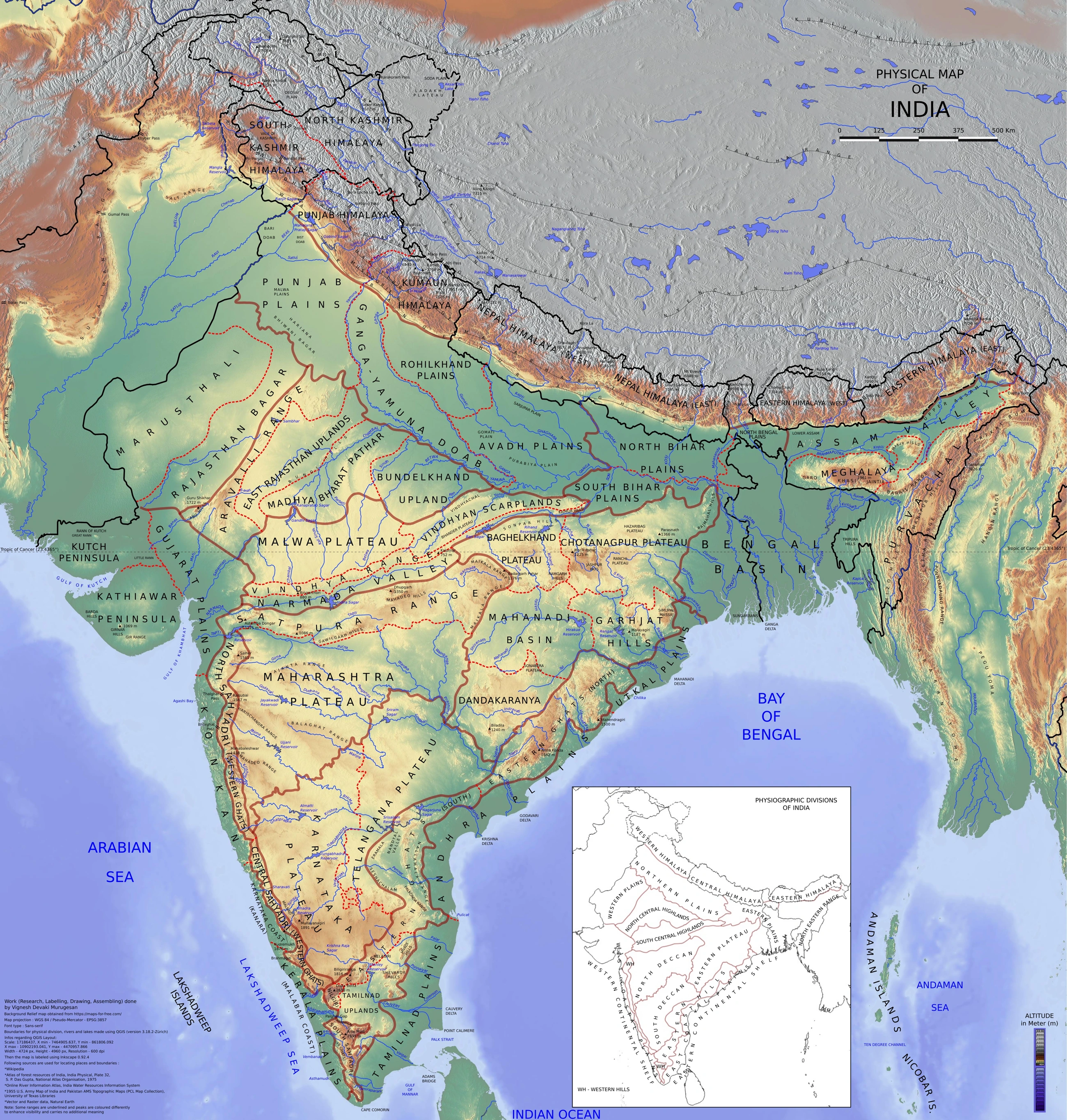
Map study
Physical divisions of India: locate mountains, plains, plateau, desert, coast and islands. Use regional relief to interpret landform processes; this is not a local geomorphological survey.
- Read the legend and reference date before interpreting regional patterns.
- Relate the map to the article’s topic; verify current administrative boundaries or data separately.
Credit: Vigneshdm1990 · CC BY-SA 4.0 · sourceConverted to WebP on an opaque white background; proportionally resized without cropping. Original cartography and legend retained.
1. Meaning and conditions for karst development
Karst refers to both a distinctive landscape and a drainage system created largely by the dissolution of soluble bedrock. Limestone, composed mainly of calcium carbonate, is its classic host rock. Dolomite also develops karst, although its dissolution behaviour differs from that of limestone. Gypsum and rock salt dissolve readily and may form caves and sinkholes, demonstrating that karst is not restricted to carbonate rocks.
Well-developed karst generally requires soluble rock, pathways for water entry, sufficient water supply and opportunities for drainage. Joints, faults and bedding planes guide initial groundwater movement. Progressive dissolution enlarges these openings into fissures and conduits. Consequently, limestone may have low primary porosity yet develop high secondary permeability. Thick, relatively pure limestone with connected fractures commonly supports extensive karst development.
Climate influences water supply, soil biological activity and reaction rates. Humid tropical environments favour strong chemical weathering and spectacular tower or cone karst. However, karst also occurs in temperate, cold and dry regions; some features are inherited from wetter past climates. Vegetation and soil respiration supply carbon dioxide to infiltrating water, while relief and the position of the water table influence the depth and direction of underground drainage.
- Karstification is the development of karst through dissolution and associated drainage reorganisation.
- Pseudokarst describes similar-looking features formed mainly by other processes, such as lava-tube caves.
2. Dissolution, groundwater and cave formation
Rainwater absorbs atmospheric carbon dioxide and usually gains additional carbon dioxide while passing through soil. The resulting weak carbonic acid reacts with calcium carbonate. The simplified reversible reaction is CaCO3 + CO2 + H2O ⇌ Ca2+ + 2HCO3−. Calcium and bicarbonate ions are transported in solution. Carbonation is therefore a major chemical-weathering process in limestone landscapes, rather than mechanical removal by abrasion alone.
Water initially follows small openings. As dissolution enlarges a fracture, it can carry more water and may enlarge further, creating preferential flow routes. Streams may disappear into swallow holes and reappear at springs. Surface catchment boundaries may not match groundwater catchment boundaries because underground conduits can cross beneath topographic divides. Dye tracing is often used to establish connections between sinking streams and springs.
Cave passages develop both below and above the water table. In the saturated or phreatic zone, dissolution can act around the whole passage, producing rounded or elliptical forms. Above the water table, vadose streams commonly incise downward, producing canyon-like passages. Falling base level, tectonic uplift or river incision may leave older passages above active drainage. Many caves therefore contain multiple levels and record several stages of landscape evolution.
- A disappearing stream enters underground drainage; a resurgence is a spring where previously sinking water returns to the surface.
- Not every cave owes its origin to ordinary downward infiltration: some develop through rising groundwater and other dissolution mechanisms.
Simplified development of limestone karst
- 1. Rainwater gains carbon dioxide from air and soil.
- 2. Weakly acidic water enters joints and bedding planes.
- 3. Calcite dissolves and dissolved ions are carried away.
- 4. Openings enlarge into conduits, caves and underground drainage routes.
- 5. Surface dissolution or collapse produces closed depressions.
- 6. Carbon dioxide loss from cave water allows carbonate deposits to form.
3. Surface solutional and residual landforms
Lapies, also called karren, are small grooves, channels and ridges etched into exposed soluble rock. On limestone pavements, widened joints form grikes, while intervening blocks are called clints. These features illustrate the close control exerted by rock structure on weathering. They should not be confused with depositional formations inside caves.
A doline or sinkhole is a closed depression, commonly circular or oval. It may develop through gradual bedrock dissolution, subsidence of overlying material or sudden collapse into an underground cavity. A swallow hole is specifically an opening through which surface water sinks; not every sinkhole has a visible stream entering it. Uvalas are larger, irregular closed depressions, often associated with the joining of smaller depressions.
A polje is a large, usually elongated, closed karst depression with a comparatively flat floor and steep margins. Its development may involve structural controls, dissolution and sediment accumulation. Water often drains through openings called ponors. Seasonal flooding occurs when inflow exceeds underground drainage capacity. Dolines, uvalas and poljes should not be treated as an inevitable, universal evolutionary sequence.
Cone and tower karst consist of residual limestone hills separated by depressions or plains. Tower karst has particularly steep-sided residual hills, as seen around Guilin in China. Blind valleys terminate where streams disappear underground, while dry valleys lack permanent surface streams following drainage diversion or changed hydrological conditions.
| Feature | Identifying characteristic | Dominant process |
|---|---|---|
| Lapies or karren | Grooves and ridges on exposed limestone | Surface dissolution |
| Doline | Closed, commonly rounded depression | Dissolution, subsidence or collapse |
| Polje | Large, flat-floored closed depression | Dissolution with structural and sedimentary influences |
| Stalactite | Hangs from a cave ceiling | Mineral precipitation |
| Stalagmite | Rises from a cave floor | Mineral precipitation |
| Column | Connects cave floor and ceiling | Joining of growing speleothems |
4. Cave deposits and geographical distribution
Dissolution excavates many limestone caves, but deposition creates their familiar mineral decorations, collectively called speleothems. When calcium-bicarbonate-bearing water enters a cave with lower carbon dioxide pressure, it can lose carbon dioxide and precipitate calcium carbonate. Evaporation may contribute, but carbon dioxide loss is often the principal control. The simplified depositional reaction reverses the dissolution reaction.
Stalactites grow downward from ceilings, and stalagmites grow upward where mineral-bearing drops reach the floor. Their union forms a column or pillar. Thin, hollow stalactites are called soda straws. Water spreading over walls or floors deposits flowstone, while water following sloping ceilings can produce curtains or draperies. These are depositional features; the cave chamber itself is generally an erosional or dissolutional feature.
Important global karst regions include the Dinaric belt of southeastern Europe, southern China, northern Vietnam and parts of the United States. In India, Meghalaya contains extensive limestone cave systems, particularly in the Khasi and Jaintia Hills. Other examples include Borra Caves in Andhra Pradesh, Belum Caves in Andhra Pradesh and Kotumsar Cave in Chhattisgarh. Karst may be partly hidden beneath soil or younger sediments rather than exposed as bare limestone.
- Speleothem growth layers and isotopic composition can provide records of past rainfall and monsoon variability.
- Cave deposits are fragile archives; touching, breaking or removing them damages scientific and heritage value.
5. Environmental significance and examination approach
Karst aquifers supply water to settlements, agriculture and ecosystems. Their rapid conduit flow, however, can allow sewage, pesticides or industrial contaminants to travel quickly with limited filtration. A polluted sinkhole may affect a distant spring. Groundwater protection must therefore consider recharge zones and underground connections rather than only the immediate surroundings of a well.
Subsidence and sinkhole collapse threaten roads, buildings and pipelines. Groundwater withdrawal, altered drainage, leakage from water infrastructure and excavation can trigger or worsen instability in susceptible settings. Geological mapping, groundwater monitoring and geotechnical investigations are important before construction. Quarrying and poorly managed tourism can damage caves, disturb specialised fauna and change cave microclimates.
For Prelims, classify each feature by dominant process, position and drainage relationship. Distinguish solutional surface forms from cave deposits, and distinguish rock solubility from permeability. Avoid absolute statements that karst occurs only in limestone, only in humid climates or entirely without surface streams. The most useful conceptual chain connects soluble rock and fractures to chemical weathering, underground drainage, distinctive relief and environmental vulnerability.
- Dissolution dominates the formation of limestone cavities; precipitation builds most carbonate speleothems.
- Rapid groundwater flow does not imply abundant or easily accessible groundwater everywhere in a karst region.
Real-world case studies
Meghalaya: caves, rainfall and limestone
Meghalaya's limestone belts host important caves such as Mawsmai and Krem Mawmluh. High rainfall and fractured carbonate rocks support active underground drainage. Mawmluh cave deposits have also been used in palaeoclimate research. The region illustrates the need to balance limestone extraction, tourism, groundwater protection and conservation of cave environments.
Guilin and Yangshuo, China: residual tower karst
The Li River landscape around Guilin and Yangshuo contains steep limestone towers and intervening lowlands. It illustrates prolonged carbonate dissolution interacting with river processes and landscape evolution. Its residual hills contrast sharply with the small-scale grooves of limestone pavements, showing the wide range of scales represented by karst landforms.
Previous year questions
No source-linked PYQ is available here yet. Use the practice questions below.
Practice questions
Practice MCQ 1
With reference to karst landscapes, consider the following statements: 1. Fractures can give limestone high secondary permeability. 2. Groundwater catchment boundaries must coincide with surface drainage divides. 3. Karst features can develop in gypsum. Which of the statements given above are correct?
- A. 1 and 2 only
- B. 1 and 3 only
- C. 2 and 3 only
- D. 1, 2 and 3
Practice MCQ 2
Which one of the following pairs is correctly matched?
- A. Stalactite: Deposit growing upward from a cave floor
- B. Grike: Limestone block between widened joints
- C. Polje: Large, usually flat-floored closed karst depression
- D. Lapies: Carbonate column joining a cave ceiling and floor
Practice MCQ 3
Calcium-carbonate-rich water enters a cave and loses carbon dioxide. Which outcome is most directly favoured?
- A. Precipitation of calcium carbonate
- B. Conversion of limestone into granite
- C. Mechanical abrasion of the cave ceiling
- D. Formation of glacial till
Mains practice · Explain how rock structure and groundwater processes shape karst landscapes. Why do such regions require distinctive approaches to water-resource management and infrastructure planning? Answer in 250 words.
- Define karst and identify soluble rocks and fracture-controlled permeability.
- Explain carbonation, conduit enlargement and underground drainage.
- Illustrate surface landforms and distinguish them from depositional speleothems.
- Discuss contamination vulnerability and mismatches between surface and groundwater catchments.
- Explain sinkhole hazards and the effects of altered drainage or groundwater withdrawal.
- Suggest recharge-zone protection, dye tracing, monitoring and geotechnical assessment; use Meghalaya as an example.
Further reading
- NCERT, Fundamentals of Physical Geography, Class XI: Geomorphic Processes; Landforms and their Evolution.
- Geological Survey of India: publications on limestone geology and Indian cave landscapes.
- United States Geological Survey: educational resources on karst aquifers and sinkholes.
- UNESCO World Heritage Centre: South China Karst.
Preparing for UPSC Civil Services? Get classroom teaching, answer-writing evaluation and mentorship at Pragnya IAS Academy, Ashok Nagar — see why aspirants choose us for IAS coaching in Hyderabad.