
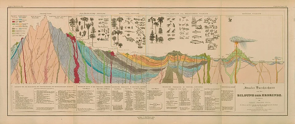
Historical diagram of Earth’s crust attributed to Alexander von Humboldt (1841), reproduced in Berghaus’s Physikalischer Atlas.
Credit: Alexander von Humboldt · Public domain · sourceResized and converted to WebP; uncropped.
1. Meaning, extent and composition
The crust is the rocky outer shell of Earth, lying above the mantle. In the compositional classification of Earth’s interior, the principal layers are crust, mantle and core. This differs from the mechanical classification into lithosphere, asthenosphere and deeper layers, which is based on strength and deformation behaviour. The crust includes exposed continental rocks, rocks beneath sediments, and the bedrock underlying the oceans. Seawater is not part of the crust.
The crust constitutes less than 1% of Earth’s volume. Its thickness is highly variable: it can be especially thin in tectonically stretched regions and beneath oceans, but thick beneath major continental mountain belts. Continents therefore cannot be understood merely as land rising above sea level; continental crust also extends beneath submerged continental shelves.
Oxygen is the most abundant element in the crust by mass, followed by silicon. Aluminium, iron, calcium, sodium, potassium and magnesium account for most of the remainder. Feldspars are the most abundant mineral group in the crust, while quartz is particularly common in silica-rich continental rocks. Crustal rocks are classified as igneous, sedimentary and metamorphic according to their origin, not simply their chemical composition.
- Crust refers to a compositional layer; land surface refers to topography.
- Sedimentary rocks cover extensive surface areas but form only a relatively thin portion of the crust.
- Crustal composition varies with depth and location; no single rock represents the entire layer.
2. Continental and oceanic crust
Continental crust is thick, compositionally varied and comparatively buoyant. Typical thickness is about 30–50 km, with a global average commonly placed around 35–40 km. Beneath parts of the Himalaya–Tibet region it exceeds 70 km. Its upper portion is generally more felsic, or rich in silica and feldspar, whereas its lower portion is commonly more mafic. Although frequently described as granitic in elementary geography, the bulk continental crust is closer to an intermediate composition.
Oceanic crust is thinner and denser. Normal oceanic crust is about 6–7 km thick, although oceanic plateaus and other anomalous regions can be substantially thicker. It consists chiefly of basaltic and gabbroic rocks. A typical sequence includes a sediment cover, basaltic lava flows, sheeted dykes and deeper gabbroic rocks. Below these lies ultramafic mantle rock, mainly peridotite.
Representative densities used in introductory geography are about 2.7 g/cm³ for continental crust and about 3.0 g/cm³ for oceanic crust, though actual values vary. Lower density and greater thickness help continents stand higher than ocean basins. Continental crust preserves rocks older than 4 billion years, whereas most surviving oceanic crust is younger than about 200 million years because it is continually created and recycled.
- Traditional sial refers to silica- and aluminium-rich material; sima refers to silica- and magnesium-rich material.
- Sial and sima are useful historical terms, not a precise modern division into two continuous global shells.
- Basalt and gabbro have broadly similar compositions but different textures because they cool at different rates.
Typical oceanic crust formation and recycling
- 1. Plate divergence permits mantle upwelling.
- 2. Pressure reduction causes partial melting of mantle rock.
- 3. Magma crystallises or erupts, forming basaltic–gabbroic oceanic crust.
- 4. Seafloor spreading carries crust away from the ridge as lithosphere cools and thickens.
- 5. Oceanic lithosphere may eventually subduct at a convergent boundary.
3. Boundaries and evidence about the crust
Direct knowledge of the crust comes from outcrops, mines, boreholes, volcanic material and rocks brought to the surface by tectonic processes. However, direct sampling reaches only a small fraction of Earth’s interior. Russia’s Kola Superdeep Borehole reached approximately 12.26 km and remained within continental crust. Much of our understanding therefore depends on indirect geophysical evidence.
Seismic waves provide the most important evidence for crustal structure. Their velocities and paths change with the elastic properties and density of the materials they cross. In 1909, Andrija Mohorovičić identified evidence of a major boundary beneath the crust through earthquake-wave observations. Across this boundary, now called the Moho, seismic velocities generally increase as crustal rocks give way to mantle rocks.
The Moho is a compositional boundary, not the boundary between solid and liquid Earth. The mantle immediately beneath it is predominantly solid. The Conrad discontinuity is a seismic boundary identified within continental crust in some regions, historically associated with an upper–lower crustal contrast. It is not a universal feature and should not be treated as a continuous boundary beneath both continents and oceans.
The lithosphere consists of the crust plus the mechanically rigid uppermost mantle. It overlies the weaker asthenosphere, which remains predominantly solid but can deform over geological time. Consequently, the Moho and the lithosphere–asthenosphere boundary are different boundaries defined by different properties.
- Gravity measurements, heat-flow studies and seismic imaging complement rock samples.
- Both P waves and S waves travel through ordinary solid crustal rocks.
- A tectonic plate may contain both continental and oceanic crust.
| Feature | Continental crust | Oceanic crust |
|---|---|---|
| Typical thickness | About 30–50 km; thicker beneath major mountain belts | About 6–7 km for normal oceanic crust |
| Composition | Heterogeneous; felsic upper crust and more mafic lower crust | Predominantly mafic basalt and gabbro |
| Representative density | About 2.7 g/cm³ | About 3.0 g/cm³ |
| Age | Includes rocks older than 4 billion years | Mostly younger than about 200 million years |
| Tectonic behaviour | Relatively buoyant; commonly thickens during collision | Regularly generated at ridges and recycled at subduction zones |
4. Formation, recycling and vertical adjustment
Earth’s earliest crust developed as the young planet cooled and differentiated. The present crust is not an unchanged primordial shell. Melting, magmatic addition, deformation, metamorphism, weathering and erosion have repeatedly modified it. Continental crust has grown through several processes, including magmatism associated with subduction, the addition of island arcs and repeated reworking of older rocks.
Most new oceanic crust forms at divergent plate boundaries. As mantle material rises beneath a mid-ocean ridge, decreasing pressure causes partial melting. Magma crystallises at depth or erupts as basalt on the seafloor. As the oceanic lithosphere moves away from the ridge, it cools, thickens and generally becomes denser. At convergent boundaries, sufficiently dense oceanic lithosphere can descend into the mantle through subduction.
Continental collision commonly shortens and thickens crust, producing mountain belts and deep crustal roots. Because continental crust is relatively buoyant, it resists wholesale subduction compared with oceanic lithosphere, although continental material can be carried to considerable depths during collision.
Isostasy describes the tendency of the lithosphere to maintain gravitational balance over the underlying mantle. In the Airy model, high terrain is supported by thicker crustal roots; in the Pratt model, lateral density differences help explain elevation differences. Actual landscapes also reflect lithospheric strength and mantle dynamics. Removal of ice or eroded rock can cause uplift, while sediment or ice loading can cause subsidence.
- Divergence commonly creates oceanic crust; convergence commonly recycles oceanic lithosphere.
- Isostatic adjustment is generally gradual because mantle deformation takes time.
- Weathering produces regolith from crustal rocks; soil formation additionally involves biological and other processes.
5. Indian examples and examination relevance
India illustrates contrasting crustal settings. The Peninsular region contains ancient continental nuclei, or cratons, including the Dharwar, Singhbhum and Bastar cratons. These preserve long geological histories and host important mineral resources. The Himalaya represents a much younger zone of continental collision, crustal shortening and active deformation associated with convergence between the Indian and Eurasian plates.
The Deccan Traps are extensive continental flood basalts emplaced around 66 million years ago. Their basaltic composition does not make the underlying region oceanic crust: volcanic rocks can cover continental basement. Likewise, a continental shelf is submerged continental crust, not automatically oceanic crust. These distinctions are especially useful for statement-based Prelims questions.
Crustal structure influences relief, drainage, groundwater storage, mineral occurrence and earthquake hazards. Fractures and faults can guide groundwater movement, while particular geological settings favour metallic ores or sedimentary resources. Nevertheless, earthquakes and volcanism should be explained through tectonic processes rather than through crustal thickness alone; ancient continental interiors can also experience damaging earthquakes.
- Do not equate continent with plate: the Indian Plate includes continental and oceanic domains.
- Do not equate basalt at the surface with oceanic crust.
- Do not confuse the crust–mantle boundary with a solid–liquid boundary.
Earth’s Crust: Historical Illustration and Modern Interpretation
The metadata identifies this image as a historical cross-section of Earth’s crust attributed to Alexander von Humboldt. It is directly relevant as an illustration of early attempts to represent Earth’s outer structure, but should not be treated as a modern seismic model. Present understanding distinguishes continental crust, which is generally thicker and less dense, from oceanic crust, which is generally thinner, denser and predominantly basaltic in bulk composition. Continental crust is compositionally diverse; describing it simply as a uniform granite layer is misleading.
The crust is a compositional division, whereas the lithosphere is a mechanically defined layer comprising the crust and rigid uppermost mantle. Thus, tectonic plates are not merely pieces of crust. The Mohorovičić discontinuity, or Moho, marks the crust–mantle boundary and is principally identified through changes in seismic-wave velocities. In India, crustal thickening beneath the Himalaya reflects continental collision, while the peninsular shield contains ancient continental crust. These regional interpretations require modern geophysical and geological evidence; the supplied historical metadata does not establish Indian crustal structure or the diagram’s scientific accuracy.
- Prelims distinction: the Moho separates crust from mantle; it is not the lithosphere–asthenosphere boundary.
- Oceanic crust is continually created at spreading ridges and recycled at subduction zones; continental crust can preserve much older rocks.
- Mains application: connect Himalayan crustal thickening with convergence and isostatic support, without assuming that crustal thickness alone determines surface elevation.
Real-world case studies
Himalaya–Tibet: thickened continental crust
The India–Eurasia collision, underway by roughly 50 million years ago, produced crustal shortening, underthrusting and thickening. Seismic studies identify crust exceeding 70 km beneath parts of Tibet. This illustrates why high mountains may possess deep crustal roots and why surface elevation alone does not reveal the depth of the Moho.
Fennoscandia: adjustment after ice unloading
Sweden and Finland continue to rise following the melting of the Scandinavian ice sheet after the last glacial period. Uplift near the northern Gulf of Bothnia approaches 1 cm annually in some areas. This glacial isostatic adjustment demonstrates the long-term mechanical response of the lithosphere and mantle to changes in surface loading.
Previous year questions
No source-linked PYQ is available here yet. Use the practice questions below.
Practice questions
Practice MCQ 1
With reference to Earth’s outer layers, consider the following statements: 1. The lithosphere includes the crust and part of the upper mantle. 2. The Moho separates the lithosphere from the asthenosphere. 3. Continental shelves are generally underlain by continental crust. Which of the statements given above are correct?
- A. 1 and 2 only
- B. 1 and 3 only
- C. 2 and 3 only
- D. 1, 2 and 3
Practice MCQ 2
Which one of the following best explains why most surviving oceanic crust is geologically younger than continental crust?
- A. Oceanic crust cannot preserve any radioactive minerals.
- B. Seawater dissolves the entire oceanic crust at regular intervals.
- C. Oceanic lithosphere is continually generated and recycled through plate tectonics.
- D. Continental crust stopped forming before oceanic crust first appeared.
Practice MCQ 3
Consider the following statements: 1. Basaltic lava can occur over continental crust. 2. The mantle immediately below the Moho is entirely liquid. 3. Removal of a large ice load can lead to gradual uplift of the underlying land. Which of the statements given above are correct?
- A. 1 only
- B. 2 and 3 only
- C. 1 and 3 only
- D. 1, 2 and 3
Mains practice · Distinguish continental crust from oceanic crust. Explain how plate tectonics and isostasy account for their contrasting relief and geological histories. Answer in 250 words.
- Compare thickness, composition, density and age.
- Distinguish crust from lithosphere and identify the Moho.
- Explain oceanic crust generation at ridges and recycling through subduction.
- Explain continental buoyancy, survival of ancient crust and collision-related thickening.
- Connect isostasy with mountain roots and adjustment to loading or unloading.
- Use the Himalaya–Tibet region and Fennoscandian uplift as examples.
Further reading
- NCERT, Fundamentals of Physical Geography, Class XI: Interior of the Earth; Distribution of Oceans and Continents; Minerals and Rocks.
- United States Geological Survey, This Dynamic Earth: The Story of Plate Tectonics.
- Geological Survey of India: publications and geological maps on Indian cratons, the Himalaya and the Deccan volcanic province.
- British Geological Survey: educational resources on Earth structure and plate tectonics.
- https://commons.wikimedia.org/wiki/File:Alexander_von_Humboldt_-_Diagram_of_a_cross-section_of_the_earth%27s_crust_-_rectified.jpg
Preparing for UPSC Civil Services? Get classroom teaching, answer-writing evaluation and mentorship at Pragnya IAS Academy, Ashok Nagar — see why aspirants choose us for IAS coaching in Hyderabad.