
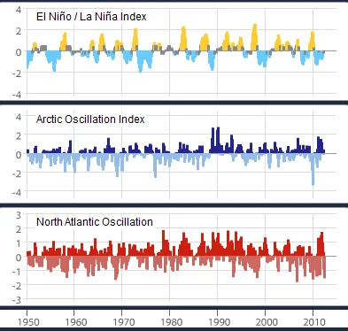
ENSO, Arctic Oscillation and North Atlantic Oscillation indices, 1950–2012; ENSO provides the El Niño context.
Credit: NOAA · Public domain · sourceResized and converted to WebP; uncropped.
1. Meaning, spatial setting and scientific identification
El Niño originally referred to a warm coastal current noticed by fishers off Peru and Ecuador around Christmas. The Spanish expression means “the boy”, traditionally referring to the Christ child. In modern climatology, it describes sustained, abnormal warming across parts of the central and eastern equatorial Pacific, coupled with changes in tropical atmospheric circulation. It is not simply a warm current, a cyclone, or the normal seasonal warming of an ocean.
El Niño forms the oceanic warm phase of the El Niño–Southern Oscillation, or ENSO. The Southern Oscillation is the associated fluctuation in atmospheric pressure across the tropical Pacific. Its conventional index, the Southern Oscillation Index, uses the standardised pressure difference between Tahiti and Darwin. Sustained negative values commonly accompany El Niño, while positive values commonly accompany La Niña.
Monitoring agencies examine sea-surface temperature anomalies, trade winds, atmospheric pressure, cloudiness and subsurface ocean heat. NOAA’s conventional Oceanic Niño Index uses three-month running mean temperature anomalies in Niño 3.4. A threshold of at least +0.5°C for five consecutive overlapping three-month seasons identifies warm episodes in its historical classification. Operational declarations also consider atmospheric coupling and forecasts; thresholds and procedures differ among agencies.
- An anomaly is a departure from a specified climatological average, not the absolute ocean temperature.
- ENSO-neutral means that neither El Niño nor La Niña dominates; it does not guarantee normal rainfall everywhere.
2. Formation: trade winds, thermocline and feedback
Under normal tropical Pacific conditions, easterly trade winds push warm surface water westward towards Indonesia and the western Pacific. This creates a western warm pool and a thermocline that is relatively deep in the west and shallow in the east. The thermocline is the layer where temperature decreases rapidly with depth. Along the South American coast, winds and ocean circulation favour the upwelling of colder, nutrient-rich water.
The Walker circulation connects these ocean conditions with the atmosphere. Warm western Pacific waters support rising moist air, cloud formation and heavy rainfall. Air flows eastward aloft, descends over the cooler eastern Pacific, and returns westward near the surface. This is primarily an east–west circulation, unlike the broadly north–south Hadley circulation.
El Niño develops when the easterly trades weaken, sometimes with episodic westerly wind bursts. Warm water spreads eastward, while downwelling equatorial Kelvin waves can deepen the eastern thermocline. Cold-water upwelling and its cooling effect weaken, allowing additional surface warming. The reduced east–west temperature contrast further weakens the trades: this mutually reinforcing ocean–atmosphere interaction is the Bjerknes feedback.
Rain-bearing convection consequently shifts towards the central or eastern Pacific, and the usual Walker circulation weakens or becomes reorganised. Eventually, redistribution and discharge of equatorial ocean heat, wave adjustments and changing winds help end the event. El Niño is therefore an evolving coupled process, not a permanent reversal of the trade winds.
- Weaker upwelling reduces nutrient supply and biological productivity off Peru.
- Eastern-Pacific and central-Pacific events have different warming patterns, helping explain variations in their distant effects.
Simplified El Niño development
- 1. Equatorial Pacific easterly trade winds weaken.
- 2. Warm water shifts eastward and downwelling Kelvin waves propagate.
- 3. The eastern thermocline deepens and cold-water cooling weakens.
- 4. Central and eastern equatorial Pacific surface temperatures rise.
- 5. Convection shifts eastward and Walker circulation reorganises.
- 6. Ocean–atmosphere feedback reinforces warming and generates teleconnections.
3. Global climatic and ecological effects
El Niño influences distant regions through atmospheric teleconnections: changes in tropical heating modify circulation, jet streams and storm tracks. Indonesia and parts of Australia often face reduced rainfall and higher drought or wildfire risk. Coastal Peru and Ecuador may experience intense rainfall and flooding, especially during strong eastern-Pacific events. These patterns depend on the season, event strength and location of peak warming.
In the eastern Pacific, a deeper thermocline and reduced nutrient availability can disrupt plankton production, fish distribution and seabird populations. Peru’s anchoveta fishery is particularly sensitive to ocean conditions, although fishing pressure and management also affect outcomes. Warm ocean conditions associated with strong events can contribute to widespread coral bleaching, superimposed on long-term ocean warming.
El Niño commonly raises global average surface temperature, with the temperature response often extending into the following calendar year. It adds short-term variability to human-induced warming rather than replacing it as an explanation. Tropical cyclone activity also changes: Atlantic hurricane activity is often suppressed through increased vertical wind shear, whereas conditions may become more favourable in parts of the central and eastern North Pacific.
- Teleconnections alter probabilities, not certainties; effects cannot be applied uniformly to an entire continent.
- ENSO is naturally occurring, while climate change modifies its background conditions and associated risks.
| Feature | Neutral | El Niño | La Niña |
|---|---|---|---|
| Central/eastern equatorial Pacific temperature | Near seasonal average | Warmer than average | Cooler than average |
| Equatorial easterly trade winds | Near normal | Generally weaker | Generally stronger |
| Eastern Pacific thermocline | Relatively shallow | Deeper than normal | Shallower than normal |
| Eastern Pacific upwelling | Normally active | Generally weakened | Generally enhanced |
| Indian southwest monsoon tendency | No dominant ENSO signal | Higher deficient-rainfall risk | Often favours stronger rainfall |
4. El Niño and the Indian monsoon
El Niño generally has an inverse relationship with India’s June–September southwest monsoon rainfall. The eastward shift in tropical Pacific convection can reorganise the Walker circulation and favour anomalous subsidence over parts of the Indian region. Changes in moisture transport and monsoon circulation may weaken rainfall or contribute to prolonged dry spells. The timing of event development is important because an event peaking after the monsoon need not have the same effect as one established early.
However, an El Niño year is not automatically an Indian drought year. The Indian Ocean Dipole, Indian Ocean temperatures, Eurasian snow conditions, monsoon depressions and intraseasonal oscillations also influence rainfall. A positive Indian Ocean Dipole, characterised by a relatively warmer western equatorial Indian Ocean and cooler southeastern waters, can sometimes counteract an adverse ENSO influence. It does not provide a guaranteed offset.
For agriculture, rainfall distribution matters as much as the seasonal total. Delayed sowing, long breaks, heat stress and inadequate reservoir recharge can affect kharif crops, hydropower and subsequent irrigation. Rainfed farming areas are particularly exposed. Conversely, El Niño can favour enhanced northeast monsoon rainfall over parts of southern peninsular India in some years; the southwest monsoon relationship should not be mechanically extended to every season.
- Assess El Niño alongside regional rainfall forecasts, soil moisture, reservoir storage and crop calendars.
- Separate all-India seasonal rainfall from district-level drought: the two can diverge substantially.
5. Monitoring, preparedness and examination relevance
ENSO monitoring combines satellite observations with moored buoys, drifting buoys, ships and profiling floats. The Tropical Atmosphere Ocean array and its associated international observing networks provide valuable measurements of equatorial Pacific winds and ocean temperatures. Subsurface observations matter because stored warm water can signal developing conditions before a large surface anomaly appears.
In India, the India Meteorological Department incorporates ENSO information into monsoon forecasting, while the Indian Institute of Tropical Meteorology contributes climate research and modelling. WMO coordinates international ENSO updates. Forecasts remain uncertain, especially across the boreal spring predictability barrier, when the subsequent evolution of ENSO is relatively difficult to predict.
Preparedness should use forecasts as risk information rather than deterministic warnings. District agricultural contingency plans, appropriate sowing advisories, short-duration crop varieties where suitable, water budgeting and reservoir coordination can reduce losses. For Prelims, prioritise the Pacific location, weakened easterlies, deeper eastern thermocline, reduced upwelling and the non-absolute monsoon relationship.
- El Niño is not the Indian Ocean Dipole: they occur in different ocean basins.
- La Niña is not simply the exact reverse of every El Niño impact; responses vary by region and season.
El Niño as internal climate variability
The metadata identifies an ENSO time series measured by the Oceanic Niño Index (ONI), alongside Arctic and North Atlantic oscillation indices. This makes the image relevant to El Niño while providing comparative climate context. ONI tracks three-month running mean sea-surface temperature anomalies in the equatorial Pacific’s Niño 3.4 region. Sustained positive anomalies meeting specified criteria indicate El Niño conditions; a single warm reading is insufficient. Unlike a seasonal temperature cycle, ENSO fluctuates irregularly between warm, cool and neutral conditions.
El Niño involves ocean–atmosphere coupling: weakened equatorial trade winds favour eastward redistribution of warm surface water, reduced cold-water upwelling in the eastern Pacific and shifts in tropical convection and the Walker circulation. These changes can influence India through atmospheric teleconnections, often increasing the risk of a weaker summer monsoon. However, Indian Ocean conditions, including the Indian Ocean Dipole, and intraseasonal variability can modify the outcome. The historical index comparison cannot by itself establish rainfall impacts in a particular Indian district or attribute an individual drought to El Niño.
- Distinguish the terms: El Niño is ENSO’s warm phase; the Southern Oscillation is its atmospheric pressure component; ONI measures an ocean-temperature anomaly.
- AO and NAO are separate circulation patterns, not phases of ENSO. Their inclusion supports comparison, not a claim that all three share identical mechanisms.
- Internal variability is not synonymous with climate change. ENSO redistributes heat and affects year-to-year global temperature, while long-term warming requires separate analysis of trends and forcings.
Real-world case studies
1997: strong El Niño without an all-India monsoon drought
The very strong 1997–98 El Niño did not produce an all-India southwest monsoon drought in 1997. A strong positive Indian Ocean Dipole was among the influences associated with the relatively favourable rainfall outcome. The event illustrates why ENSO alone cannot determine Indian seasonal rainfall.
2015: El Niño and Indian rainfall deficiency
During the developing strong 2015–16 El Niño, India’s 2015 southwest monsoon rainfall was approximately 86% of its long-period average, according to IMD. The deficiency highlighted agricultural and water-management risks, while regional differences showed why national rainfall totals require local interpretation.
Previous year questions
No source-linked PYQ is available here yet. Use the practice questions below.
Practice questions
Practice MCQ 1
Which combination is most consistent with a developing El Niño?
- A. Stronger easterly trades and a shallower eastern Pacific thermocline
- B. Weaker easterly trades and a deeper eastern Pacific thermocline
- C. Stronger easterly trades and intensified Peruvian upwelling
- D. Weaker easterly trades and persistent cooling of Niño 3.4
Practice MCQ 2
Consider the following statements: 1. The Southern Oscillation Index conventionally uses pressure observations from Tahiti and Darwin. 2. Sustained negative values commonly accompany El Niño. 3. Every El Niño causes an all-India monsoon drought. Which statements are correct?
- A. 1 and 2 only
- B. 2 and 3 only
- C. 1 and 3 only
- D. 1, 2 and 3
Practice MCQ 3
Why can El Niño adversely affect fisheries off Peru?
- A. It permanently stops the Humboldt Current.
- B. It increases nutrient-rich upwelling throughout the eastern Pacific.
- C. It reduces nutrient supply to surface waters and alters marine productivity.
- D. It causes the continental shelf to subside.
Mains practice · Explain the ocean–atmosphere interactions responsible for El Niño. Why should its occurrence be treated as a risk indicator rather than a definitive forecast of Indian monsoon drought? Answer in 250 words.
- Describe normal trade winds, western warm pool, thermocline slope and Walker circulation.
- Explain weakened trades, eastward warm-water movement, reduced upwelling and Bjerknes feedback.
- Link shifting convection with monsoon circulation and rainfall variability.
- Discuss Indian Ocean Dipole, intraseasonal variability and event timing.
- Contrast the Indian monsoon outcomes of 1997 and 2015.
- Conclude with probabilistic forecasting and district-level preparedness.
Further reading
- NCERT, Class XI, Fundamentals of Physical Geography: Atmospheric Circulation and Weather Systems.
- NCERT, Class XI, India: Physical Environment: Climate.
- India Meteorological Department: ENSO and Indian Ocean Dipole updates; monsoon season reports.
- NOAA Climate Prediction Center: ENSO diagnostic discussions and Oceanic Niño Index documentation.
- World Meteorological Organization: El Niño/La Niña Updates.
- https://commons.wikimedia.org/wiki/File:3_examples_of_internal_climate_variability_(1950-2012),_the_El_Ni%C3%B1o_%E2%80%93_Southern_Oscillation,_the_Arctic_Oscillation,_and_the_North_Atlantic_Oscillation_(NOAA).png
Preparing for UPSC Civil Services? Get classroom teaching, answer-writing evaluation and mentorship at Pragnya IAS Academy, Ashok Nagar — see why aspirants choose us for IAS coaching in Hyderabad.