
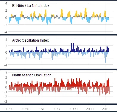
ENSO, Arctic Oscillation and North Atlantic Oscillation indices, 1950–2012; the ENSO series provides context for La Niña.
Credit: NOAA · Public domain · sourceResized and converted to WebP; uncropped.
1. Meaning, geographical setting and identification
La Niña is a large-scale, coupled ocean–atmosphere condition in which sea-surface temperatures across the central and eastern equatorial Pacific become persistently cooler than the relevant climatological average. It forms the cold phase of the El Niño–Southern Oscillation, or ENSO. El Niño is the warm phase, while neutral conditions occur when neither phase is sufficiently established. The Southern Oscillation is ENSO’s atmospheric component: variations in tropical Pacific pressure are linked with changes in winds, rainfall and ocean temperatures.
Monitoring focuses on several equatorial Pacific regions, especially Niño 3.4. Under NOAA’s traditional Oceanic Niño Index convention, a three-month running mean sea-surface temperature anomaly of −0.5°C or below, sustained for at least five overlapping three-month seasons, identifies historical cold episodes. Operational declarations also consider atmospheric coupling, subsurface conditions and forecasts. Thresholds and reference periods can differ between agencies, so an index value alone should not be treated as a universal declaration rule.
A cold patch near Peru is therefore not sufficient evidence of an established La Niña. The important feature is a coherent and persistent interaction between ocean cooling and atmospheric circulation. Likewise, the normal presence of cold water in the eastern Pacific is not itself La Niña: the phenomenon concerns departures from normal conditions.
- Principal monitoring regions include Niño 1+2 near South America, Niño 3, Niño 3.4 and Niño 4.
- The Southern Oscillation Index uses the pressure difference between Tahiti and Darwin; sustained positive values generally accompany La Niña.
2. Formation: trade winds, upwelling and feedback
Under normal tropical Pacific conditions, easterly trade winds push warm surface water westwards. Warm water accumulates near Indonesia and the western Pacific, where rising moist air supports deep convection and heavy rainfall. Farther east, winds and equatorial surface-water divergence help bring cooler subsurface water towards the surface. The thermocline, the layer in which temperature decreases rapidly with depth, is normally deeper in the west and shallower in the east.
During La Niña, stronger-than-normal easterly winds intensify this zonal contrast. They favour enhanced upwelling and cold-water influence in the central and eastern equatorial Pacific, while warm water remains concentrated farther west. The east–west sea-surface temperature gradient becomes stronger. Convection shifts towards the warmer western Pacific and Maritime Continent, and descending air becomes more prominent over the cooler central and eastern Pacific.
This supports a stronger Walker circulation, the tropical east–west atmospheric circulation involving rising air, upper-level flow, sinking air and near-surface return winds. Ocean cooling and stronger winds reinforce each other through the Bjerknes positive feedback. However, ENSO is not an indefinitely self-strengthening cycle. Changes in equatorial ocean heat content, oceanic waves and wind disturbances eventually help weaken or terminate an event.
- La Niña strengthens the typical thermocline tilt: relatively deeper in the west and shallower in the east.
- Walker circulation is primarily zonal; Hadley circulation is primarily meridional. They should not be confused.
Simplified reinforcing feedback during La Niña
- 1. Easterly trade winds strengthen over the equatorial Pacific.
- 2. Westward movement of warm surface water and eastern Pacific upwelling intensify.
- 3. Central and eastern equatorial Pacific surface waters cool further.
- 4. The east–west temperature contrast and western Pacific convection strengthen.
- 5. A stronger Walker circulation reinforces the easterly trade winds.
3. Global climate effects and teleconnections
La Niña influences distant climates through teleconnections: changes in tropical heating alter atmospheric waves, pressure systems, jet streams and storm tracks. These effects are probabilistic rather than universal. Their strength depends on the season, event intensity, location of ocean cooling and the background state of other oceans. Even two La Niña events can produce different regional weather outcomes.
Typical effects include increased rainfall over parts of Indonesia and northern or eastern Australia, with greater flood risk when favourable regional conditions coincide. Parts of the central and eastern equatorial Pacific tend to become drier. La Niña can contribute to deficient October–December short rains in equatorial East Africa, although the Indian Ocean Dipole is also important. During the Northern Hemisphere winter, southern parts of the United States often experience relatively warmer and drier conditions, while some northern areas are cooler and wetter.
La Niña generally favours Atlantic hurricane activity by reducing vertical wind shear over parts of the tropical Atlantic. This does not predict the number of landfalls or guarantee an active season, because Atlantic sea temperatures and other conditions also matter. Globally, La Niña usually lowers surface temperatures relative to comparable El Niño conditions, with a lag. A La Niña year can nevertheless remain very warm because greenhouse-gas-driven warming continues.
- Vertical wind shear means a change in wind speed or direction with height.
- An ENSO association describes a change in likelihood, not certain weather at a particular location.
| Feature | La Niña | El Niño |
|---|---|---|
| Central/eastern equatorial Pacific | Cooler than normal | Warmer than normal |
| Easterly trade winds | Generally stronger | Generally weaker |
| Thermocline tilt | Generally steeper | Generally flatter |
| Pacific Walker circulation | Generally strengthened | Generally weakened and displaced |
| Indian southwest monsoon tendency | Often favourable | Often unfavourable |
4. Implications for India and the monsoon
La Niña is generally associated with favourable conditions for India’s June–September southwest monsoon. Its tropical circulation anomalies often support a stronger monsoon compared with El Niño, which more frequently weakens Indian summer rainfall. However, the relationship is statistical, not deterministic. All-India seasonal rainfall can be above normal even when some districts face drought, and a favourable seasonal total may include long dry spells interrupted by intense rain.
The Indian Ocean Dipole, Indian Ocean temperatures, Eurasian snow conditions, monsoon depressions and intraseasonal variability can reinforce or offset ENSO influences. The Madden–Julian Oscillation and boreal-summer intraseasonal oscillations affect active and break phases. ENSO’s timing also matters: a developing La Niña late in the season may have different implications from one established before monsoon onset. Consequently, La Niña alone cannot reliably predict onset, withdrawal or district-level rainfall.
The October–December northeast monsoon, important for Tamil Nadu and adjoining southeastern peninsular India, has a different ENSO relationship. El Niño often favours rainfall during this season, whereas La Niña may be associated with reduced rainfall. This is also conditional on Indian Ocean conditions and individual weather systems. Claims that La Niña necessarily causes a harsh Indian winter or more Bay of Bengal cyclones are similarly oversimplified: circulation, sea temperatures, wind shear and local conditions remain crucial.
- For agriculture, rainfall timing and distribution matter as much as seasonal totals.
- For disaster management, a wet seasonal outlook supports preparedness but cannot replace catchment-scale flood forecasting.
5. Monitoring, prediction and examination relevance
ENSO monitoring combines satellite observations, equatorial moored buoys, drifting buoys, Argo profiling floats and other ocean measurements. Scientists track sea-surface temperature anomalies, subsurface heat content, thermocline depth, trade winds, pressure indices and outgoing longwave radiation. Low outgoing longwave radiation over warm tropical waters commonly indicates high, cold cloud tops associated with deep convection.
Dynamical and statistical models provide seasonal ENSO outlooks. Forecast confidence varies with lead time and season; predictions crossing the boreal spring period often face the spring predictability barrier. ENSO outlooks must therefore be communicated as probabilities. In India, the India Meteorological Department assesses Pacific and Indian Ocean conditions when issuing monsoon forecasts, alongside information from coupled prediction systems.
For Prelims, connect La Niña with stronger easterly trade winds, enhanced eastern Pacific cooling, a steeper thermocline tilt and an intensified Walker circulation. Avoid statements claiming universal rainfall increases, an annual fixed cycle or guaranteed cooling everywhere. ENSO-neutral does not mean an absence of climate variability or extreme events. Finally, distinguish ENSO from the Indian Ocean Dipole, which concerns an east–west temperature contrast within the tropical Indian Ocean.
- La Niña commonly lasts about nine to twelve months but can persist or recur across successive years.
- A triple-dip La Niña denotes persistence or recurrence across three successive Northern Hemisphere winters, not three equally strong cooling peaks.
Reading La Niña within ENSO variability
The metadata identifies the upper series as the Oceanic Niño Index (ONI), making this a relevant illustration of La Niña within broader climate variability. ONI measures three-month running mean sea-surface temperature anomalies in the Niño 3.4 region of the equatorial Pacific. Sustained sufficiently negative anomalies indicate La Niña conditions; a single negative value is not enough to establish an episode. The Arctic Oscillation and North Atlantic Oscillation series are comparative examples of other variability patterns, not alternative measures of La Niña.
La Niña is a coupled ocean–atmosphere state, not simply a patch of cold seawater. Stronger easterly trade winds typically reinforce westward movement of warm surface water and eastern equatorial upwelling, supporting cooler central and eastern Pacific conditions. Tropical convection shifts towards the western Pacific, altering the Walker circulation and influencing distant rainfall through teleconnections. For India, La Niña often favours a stronger summer monsoon, but the Indian Ocean Dipole, intraseasonal variability and regional circulation can modify outcomes. This historical index comparison cannot by itself establish rainfall impacts across Indian regions or provide a current forecast.
- Prelims distinction: ONI tracks ocean temperature anomalies; the Southern Oscillation Index tracks atmospheric pressure differences. Their signs should not be treated as interchangeable.
- Mains caution: A favourable all-India monsoon tendency does not imply uniform rainfall, fewer dry spells or freedom from local drought.
- Evidence limit: Internal variability redistributes heat and modifies regional climate; this historical chart alone neither establishes nor disproves long-term externally forced warming.
Real-world case studies
Australia: the 2010–2012 La Niña episodes
Strong La Niña conditions contributed to exceptionally wet conditions in Australia during 2010–2012. Queensland experienced severe flooding in 2010–2011, including Brisbane in January 2011. The case illustrates how ENSO can raise seasonal flood risk, while actual damage depends on individual storms, saturated catchments, river conditions and settlement exposure.
The 2020–2023 triple-dip La Niña
La Niña persisted or recurred across three successive Northern Hemisphere winters from 2020–2021 to 2022–2023. The WMO identified it as the first triple-dip La Niña of the twenty-first century. It coincided with repeated wet episodes in eastern Australia and drought in the Horn of Africa, demonstrating contrasting teleconnections rather than uniform global rainfall effects.
Previous year questions
No source-linked PYQ is available here yet. Use the practice questions below.
Practice questions
Practice MCQ 1
With reference to La Niña, consider the following statements: 1. Equatorial Pacific easterly trade winds generally strengthen. 2. The eastern equatorial Pacific thermocline generally deepens relative to normal. 3. The east–west sea-surface temperature contrast generally increases. Which statements are correct?
- A. 1 and 2 only
- B. 1 and 3 only
- C. 2 and 3 only
- D. 1, 2 and 3
Practice MCQ 2
Which statement best describes the relationship between La Niña and Indian rainfall?
- A. It guarantees above-normal rainfall in every Indian district.
- B. It strengthens the southwest and northeast monsoons equally.
- C. It often favours southwest monsoon rainfall, but other influences modify the outcome.
- D. It determines the exact date of southwest monsoon onset.
Practice MCQ 3
La Niña often favours Atlantic hurricane activity primarily because it tends to:
- A. Reduce vertical wind shear over parts of the tropical Atlantic
- B. Eliminate the Coriolis force over the Atlantic
- C. Shift the Pacific thermocline into the Atlantic
- D. Prevent all Saharan dust transport
Mains practice · Explain the ocean–atmosphere processes underlying La Niña. Why does its occurrence not guarantee a uniformly good monsoon across India? Answer in 250 words.
- Define La Niña as ENSO’s coupled cold phase.
- Explain trade winds, upwelling, thermocline tilt, Walker circulation and Bjerknes feedback.
- Describe its generally favourable association with the southwest monsoon.
- Discuss the Indian Ocean Dipole, intraseasonal oscillations and monsoon depressions.
- Distinguish seasonal rainfall totals from spatial distribution, dry spells and extreme rainfall.
- Conclude with probabilistic forecasting and locally tailored preparedness.
Further reading
- NCERT, Class XI, Fundamentals of Physical Geography: Atmospheric Circulation and Weather Systems.
- NCERT, Class XI, India: Physical Environment: Climate.
- NOAA Climate Prediction Center: ENSO Diagnostic Discussion and historical Oceanic Niño Index.
- World Meteorological Organization: El Niño/La Niña Updates.
- India Meteorological Department: ENSO and IOD bulletins and seasonal monsoon forecasts.
- Australian Bureau of Meteorology: ENSO explanations and the 2010–2012 La Niña events.
- https://commons.wikimedia.org/wiki/File:3_examples_of_internal_climate_variability_(1950-2012),_the_El_Ni%C3%B1o_%E2%80%93_Southern_Oscillation,_the_Arctic_Oscillation,_and_the_North_Atlantic_Oscillation_(NOAA).png
Preparing for UPSC Civil Services? Get classroom teaching, answer-writing evaluation and mentorship at Pragnya IAS Academy, Ashok Nagar — see why aspirants choose us for IAS coaching in Hyderabad.