
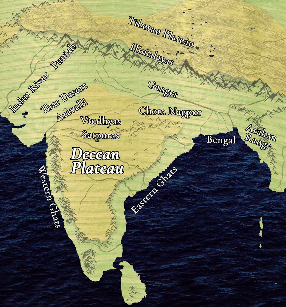
Deccan Plateau: a major southern division of India’s Peninsular Plateau.
Credit: Arjunullas · CC BY-SA 4.0 · sourceResized and converted to WebP; uncropped.
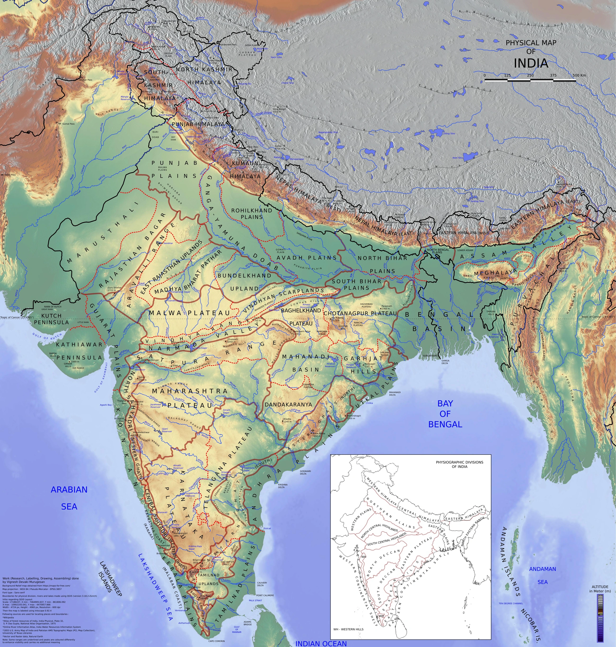
Map study
Physical divisions of India: locate mountains, plains, plateau, desert, coast and islands. Use regional relief to interpret landform processes; this is not a local geomorphological survey.
- Read the legend and reference date before interpreting regional patterns.
- Relate the map to the article’s topic; verify current administrative boundaries or data separately.
Credit: Vigneshdm1990 · CC BY-SA 4.0 · sourceConverted to WebP on an opaque white background; proportionally resized without cropping. Original cartography and legend retained.
1. Geological foundation and broad physiography
The Peninsular Plateau occupies much of India south of the Northern Plains. It is broadly triangular, although its boundaries are irregular and include several transitional uplands. The Aravalli system marks its northwestern margin, while the Central Highlands border the plains farther east. Towards the south, the plateau narrows into elevated hill systems. Unlike the young Himalayan mountain belt, the peninsula consists largely of an ancient continental foundation modified by prolonged weathering, erosion, faulting, uplift and volcanism.
Its basement includes Precambrian granites, gneisses and other metamorphic rocks. However, describing the entire plateau as a single mass of ancient crystalline rock is misleading. Vindhyan sedimentary rocks, Gondwana sedimentary basins and Deccan basalt also occupy substantial areas. The region was part of Gondwana before the Indian plate separated and moved northwards. Much later, collision with Eurasia produced the Himalayas, while the peninsular interior retained its older geological framework.
Typical landforms include rounded hills, broad valleys, rocky uplands, isolated residual hills and dissected plateaus. Elevations commonly lie between about 300 and 900 metres, though individual plateaus and mountain blocks vary considerably. The surface is neither uniformly level nor uniformly tilted. Regional uplift, differences in rock resistance and river incision explain its complex relief. Its relative tectonic stability must not be confused with inactivity: ancient faults can be reactivated, producing intraplate earthquakes.
- Shield: an exposed area of ancient crystalline continental crust.
- Escarpment: a steep slope separating surfaces at different elevations.
- Residual hill: an isolated elevation left after surrounding material has been removed by erosion.
2. Central Highlands and northeastern extensions
The Central Highlands lie mainly north of the Narmada valley and include the Malwa Plateau and adjoining uplands. The Aravallis form an ancient, highly eroded mountain system to the northwest. The Vindhyan hills and escarpments occur along the southern side of much of this northern plateau region. The Chambal, Sind, Betwa and Ken generally flow northwards or northeastwards towards the Yamuna, demonstrating that the overall eastward slope associated with the Deccan cannot be applied to every peninsular subdivision.
Malwa is largely a lava plateau extending across western Madhya Pradesh and southeastern Rajasthan. Eastwards, Bundelkhand is notable for exposed crystalline rocks, shallow soils and an undulating rocky landscape. Baghelkhand includes uplands associated with the Vindhyan and adjoining formations. These regional names describe distinct areas rather than interchangeable labels. Ravines along the Chambal and its tributaries illustrate intense gully erosion in susceptible materials, especially around the plateau–plain transition.
Farther east, the Chota Nagpur Plateau occupies much of Jharkhand and adjoining areas. Its component uplands include the Ranchi and Hazaribagh plateaus, separated or dissected by river valleys. Gondwana basins in the Damodar valley contain important coalfields, including Jharia and Bokaro. Metallic minerals occur in other geological formations, such as the iron-ore-bearing belts of Singhbhum. Thus, coal and iron ore may occur within the same broad region but do not share the same geological origin.
The Meghalaya Plateau, comprising the Garo, Khasi and Jaintia Hills, represents a northeastern extension of the peninsular block. A faulted, sediment-filled gap separates it from the main plateau. Its steep southern margin faces the Bangladesh plains and intercepts moisture-bearing monsoon winds. The exceptional rainfall around Cherrapunji and Mawsynram is therefore closely connected with relief and exposure, rather than elevation alone.
From geological foundation to present-day resource patterns
- 1. Ancient continental crust provides the basement
- 2. Sedimentation, faulting, uplift and regional volcanism modify the surface
- 3. Weathering and river erosion create soils, valleys and dissected uplands
- 4. Relief influences monsoon rainfall and drainage
- 5. Rocks, soils and water availability shape mining, agriculture and settlement
3. Deccan Plateau and its bounding hill systems
The Deccan Plateau lies mainly south of the Narmada and includes the Maharashtra, Karnataka and Telangana plateau regions. The Satpura–Mahadeo–Maikal uplands form important northern highlands. Large parts of the northwestern Deccan are covered by basaltic lava flows called the Deccan Traps. Successive lava layers and differential erosion produce characteristic step-like slopes. Weathering of basalt has contributed to extensive black-soil development, although neither all plateau soils nor all Deccan surfaces are black-soil covered.
The Western Ghats, also called the Sahyadri in their northern section, form a relatively continuous escarpment along the plateau’s western margin. Their western slopes descend steeply towards the narrow coastal plains. They are generally higher and more continuous than the Eastern Ghats and strongly influence southwest monsoon rainfall. Heavy rain falls on exposed western slopes, while much of the interior lies in a rain shadow. Bhor Ghat, Thal Ghat and the Palakkad Gap provide important transport passages.
The Eastern Ghats comprise discontinuous hill ranges along the eastern side of the peninsula. The Mahanadi, Godavari, Krishna and Kaveri river systems interrupt them on their way to the Bay of Bengal. The Western and Eastern Ghats meet in the Nilgiri region. Farther south lie the Anaimalai, Palani and Cardamom hill systems. Anamudi, in Kerala’s Western Ghats, reaches 2,695 metres and is the highest peak in peninsular India; Doddabetta is the highest peak of the Nilgiris.
- Deccan Plateau and Deccan Traps are not synonyms: the plateau extends beyond the basalt-covered region.
- The Ghats are plateau-margin hill systems, not young fold mountains comparable to the Himalayas.
| Region | Broad location | Diagnostic feature |
|---|---|---|
| Malwa Plateau | Western Madhya Pradesh and southeastern Rajasthan | Extensive basaltic terrain; drainage includes Chambal tributaries |
| Bundelkhand | Northern Madhya Pradesh and southern Uttar Pradesh | Crystalline rocky uplands; Betwa and Ken drainage |
| Chota Nagpur Plateau | Jharkhand and adjoining states | Dissected mineral-rich uplands and Gondwana coal basins |
| Deccan Plateau | Much of interior peninsular India south of the Narmada | Broad eastward slope; basalt extensive in its northwest |
| Meghalaya Plateau | Garo, Khasi and Jaintia Hills | Northeastern peninsular extension with a steep, rain-exposed southern margin |
4. Drainage, slopes and distinctive landforms
Most major rivers of the Deccan flow eastwards because of the broad regional slope towards the Bay of Bengal. The Godavari, Krishna and Kaveri originate in or near the Western Ghats and cross the plateau before reaching the eastern coast. The Mahanadi drains the east-central uplands. Their lower courses commonly develop deltas, although delta size and form depend on sediment supply, coastal processes and human modifications. Short west-flowing rivers descending the Western Ghats often have steep gradients and considerable hydropower potential.
The Narmada and Tapi are major exceptions to the dominant eastward drainage pattern. They flow westwards through structurally controlled troughs commonly described as rift valleys. The Narmada runs broadly between the Vindhyan uplands to the north and the Satpuras to the south; the Tapi flows south of the Satpuras. Their direction cannot be explained simply by assuming a uniform westward slope of the peninsula. Both discharge into the Gulf of Khambhat region.
Plateau edges, fault-related relief and variations in rock resistance generate waterfalls and gorges. Jog Falls occurs on the Sharavathi in Karnataka, while Hundru Falls occurs on the Subarnarekha in Jharkhand. Dhuandhar Falls and the Marble Rocks gorge near Jabalpur are associated with the Narmada. These examples help connect physical maps with geological controls: a waterfall may mark a resistant rock layer or an abrupt change in river-bed elevation.
5. Resources, environmental significance and map-based preparation
The plateau is central to India’s mineral and industrial geography. Chota Nagpur and adjoining eastern belts contain important coal, iron ore, mica and other mineral deposits. Bauxite often occurs as residual concentrations on suitable weathered upland surfaces. Black soils support cotton cultivation in parts of the Deccan, while red and yellow soils are widespread over crystalline terrains. Agricultural outcomes depend on rainfall, soil depth, irrigation and management; parent rock alone does not determine land productivity.
Water availability is uneven. Hard-rock aquifers generally store groundwater in weathered zones, joints and fractures rather than extensive primary pore spaces. Consequently, adjacent villages can have sharply different well yields. Seasonal rainfall, rapid runoff and excessive extraction create drought vulnerability in parts of the interior. Watershed treatment, groundwater budgeting and appropriate crop choices are therefore important. Mining, quarrying, deforestation and poorly planned construction also increase erosion, habitat fragmentation and slope instability.
For Prelims, prioritise relative locations and relationships rather than isolated lists. Trace the Narmada and Tapi against the Vindhya and Satpura ranges; identify the north-flowing Yamuna tributaries; locate the Nilgiris and Palakkad Gap; and distinguish the Meghalaya Plateau from the Himalayan and Purvanchal mountain systems. Link geological formations with resources, western escarpments with monsoon rainfall, and river gradients with waterfalls. Avoid absolute statements such as all peninsular rivers flow east or the entire plateau consists of basalt.
Deccan Plateau: Relief, Rocks and Drainage
The supplied metadata identifies the Deccan Plateau, making this image directly relevant to the Peninsular Plateau. The Deccan is the broad plateau region south of the Narmada, bordered by the Western Ghats and Eastern Ghats. It is a major division of the larger Peninsular Plateau, not a synonym for the entire physiographic region. Its general eastward slope helps explain why the Godavari, Krishna and Kaveri drain towards the Bay of Bengal, although local relief creates important departures from this pattern.
Distinguish the Deccan Plateau, a physiographic region, from the Deccan Traps, a volcanic rock province occupying only part of it. Much of the wider peninsula consists of older crystalline rocks; basalt does not underlie the entire plateau. The metadata’s references to Maharashtra, Telangana and Karnataka should not be treated as an exhaustive statement of the plateau’s extent. Metadata alone also cannot establish mapped boundaries, elevation values or individual geological units. For Indian geography, connect relief with drainage, orographic rainfall and soil formation rather than assuming that one rock type explains every landscape feature.
- Western Ghats form a more continuous western escarpment; the Eastern Ghats are discontinuous and dissected by major east-flowing rivers.
- Narmada and Tapi flow west through structurally controlled valleys; their courses caution against treating eastward drainage as universal across the peninsula.
- Basalt weathering contributes to black-soil formation, but soil distribution also reflects climate, drainage and transported material; black soils and Deccan Traps are not identical spatial units.
Real-world case studies
Koyna earthquake: a relatively stable shield can still experience seismicity
The 1967 Koyna earthquake in Maharashtra, of about magnitude 6.3, is a major example associated with reservoir-triggered seismicity. Changes in stress and pore-water pressure can activate existing fractures. The case demonstrates that the peninsular shield is relatively stable compared with active plate boundaries, not earthquake-proof.
Western Ghats: escarpment relief and conservation
The Western Ghats serial property was inscribed on the UNESCO World Heritage List in 2012. Its strong elevation and rainfall gradients support exceptional biodiversity and endemism. Forest loss, quarrying and construction on steep slopes can compound monsoon-related slope hazards, illustrating the need to integrate landform sensitivity into infrastructure planning.
Previous year questions
No source-linked PYQ is available here yet. Use the practice questions below.
Practice questions
Practice MCQ 1
Consider the following statements: 1. The Deccan Traps occupy the entire Deccan Plateau. 2. The Meghalaya Plateau is an extension of the peninsular block. 3. The Chambal and Betwa drain parts of the Central Highlands towards the Yamuna. Which statements are correct?
- A. 1 and 2 only
- B. 2 and 3 only
- C. 1 and 3 only
- D. 1, 2 and 3
Practice MCQ 2
Which one of the following correctly describes the spatial relationship between major peninsular features?
- A. The Narmada flows broadly between the Vindhyan uplands and the Satpuras.
- B. The Tapi flows north of the Vindhyan uplands.
- C. The Palakkad Gap separates the Aravallis from the Vindhyas.
- D. The Nilgiris lie north of the Maharashtra Plateau.
Practice MCQ 3
Consider the following pairs: 1. Jog Falls — Sharavathi 2. Hundru Falls — Subarnarekha 3. Dhuandhar Falls — Godavari. How many pairs are correctly matched?
- A. Only one
- B. Only two
- C. All three
- D. None
Mains practice · Explain how geological structure and relief influence the drainage, resource distribution and environmental challenges of the Peninsular Plateau. Answer in 250 words.
- Introduce the ancient shield and distinguish crystalline basement, sedimentary basins and Deccan basalt.
- Explain dominant eastward drainage, north-flowing Central Highland rivers and structurally controlled Narmada–Tapi valleys.
- Connect Gondwana basins with coal and appropriate mineralised belts with metallic ores.
- Discuss basalt-derived black soils, hard-rock groundwater and Western Ghats rainfall contrasts.
- Examine mining impacts, water stress, erosion and slope instability.
- Conclude with geological and watershed-based regional planning; add a simple labelled map.
Further reading
- NCERT, Contemporary India–I, Class IX: Physical Features of India.
- NCERT, India: Physical Environment, Class XI: Structure and Physiography; Drainage System.
- Geological Survey of India: geological maps and publications on Indian geology, gsi.gov.in.
- UNESCO World Heritage Centre: Western Ghats property description, whc.unesco.org.
- Central Ground Water Board: aquifer mapping reports for peninsular hard-rock regions, cgwb.gov.in.
- https://commons.wikimedia.org/wiki/File:Deccan_Plateau.png
Preparing for UPSC Civil Services? Get classroom teaching, answer-writing evaluation and mentorship at Pragnya IAS Academy, Ashok Nagar — see why aspirants choose us for IAS coaching in Hyderabad.