

A view from Zoji La
Credit: Wikimedia Commons · Public domain · source
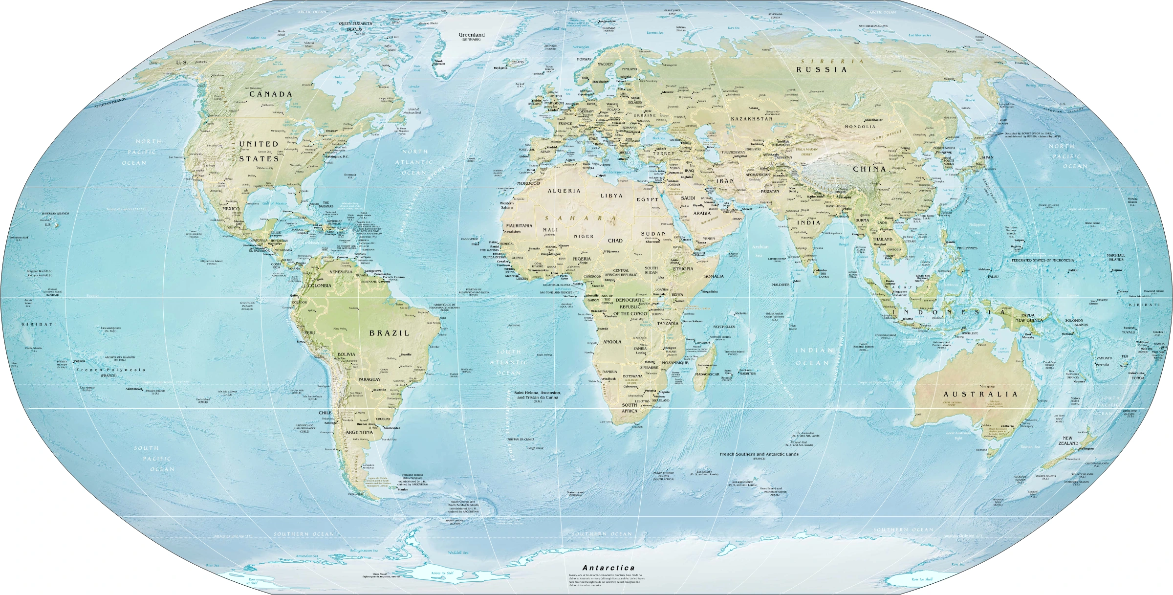
Map study
World physical relief: locate major mountain belts, plains and ocean basins. Regional orientation, not a detailed local landform survey.
- Read the source date and legend; distinguish territory, influence and geographic location.
- Historical boundaries and reference memberships are not live political or operational data.
Credit: US Government; Central Intelligence Agency · Public domain · sourceConverted to WebP on an opaque white background; proportionally resized without cropping. Original cartography and legend retained.
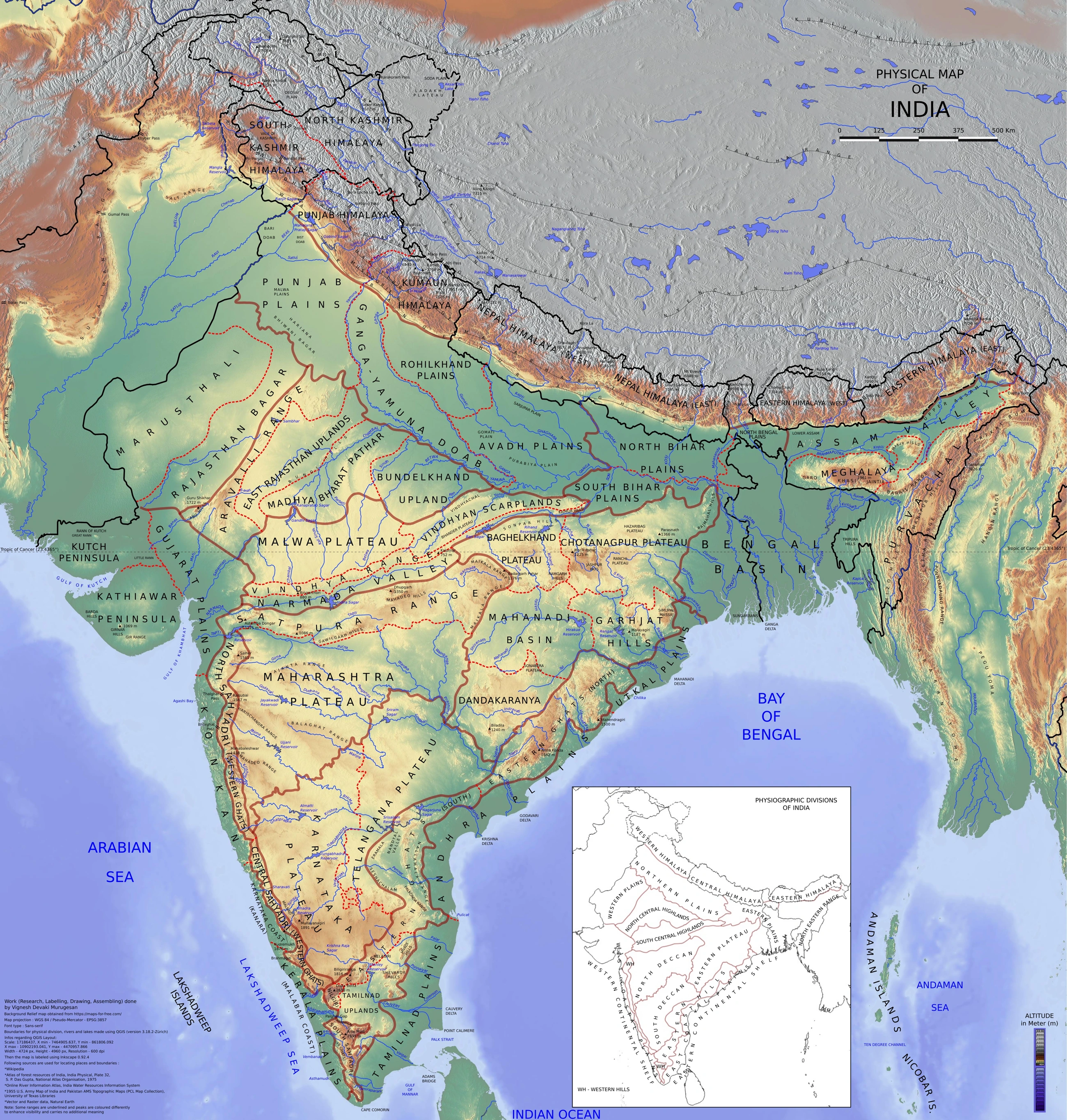
Map study
Physical divisions of India: locate mountains, plains, plateau, desert, coast and islands. Use regional relief to interpret landform processes; this is not a local geomorphological survey.
- Read the legend and reference date before interpreting regional patterns.
- Relate the map to the article’s topic; verify current administrative boundaries or data separately.
Credit: Vigneshdm1990 · CC BY-SA 4.0 · sourceConverted to WebP on an opaque white background; proportionally resized without cropping. Original cartography and legend retained.
1. Meaning, formation and geographical significance
A mountain pass is a relatively low crossing through a ridge or mountain barrier, commonly associated with a saddle between higher summits. It is low in relation to the surrounding terrain, not necessarily in absolute elevation: several Himalayan passes exceed 5,000 metres. A pass may be crossed by a foot trail, pack-animal route or motor road. Therefore, the existence of a geographical pass does not imply unrestricted access or a year-round road.
Passes develop through the combined influence of geological structure, weathering and erosion. Rivers may erode towards a watershed, while glaciers can deepen valleys and lower intervening ridges. Faults, fractures and comparatively weak rocks may guide erosion. Some crossings occupy watershed saddles; others use broader gaps or deeply incised valleys. A river gorge and a mountain pass are related features of mountain accessibility but are not interchangeable terms.
Their importance comes from the barrier effect of mountains. A relatively low crossing concentrates movement between valleys, influencing trade, migration, pilgrimage, military logistics and settlement. In the Himalaya, snow accumulation, avalanches and freeze–thaw processes restrict movement. In the Western Ghats, heavy monsoon rainfall, slope instability and sharp escarpments are major constraints. Thus, accessibility depends on relief, weather, engineering and administrative permission rather than elevation alone.
- Read a pass through four map relationships: location, mountain barrier, connected regions and nearby river or road.
- Distinguish the natural crossing from a tunnel beneath it and from the broader transport corridor that uses it.
2. Western Himalaya: Ladakh, Jammu and Kashmir, and Himachal Pradesh
The Karakoram Pass lies in the Karakoram Range on the India–China boundary between Ladakh and Xinjiang. It belonged to the historical caravan route linking the Leh region with Central Asia through the Yarkand trade network. It is not a routine civilian road crossing. Khardung La, by contrast, crosses the Ladakh Range north of Leh and provides access towards the Shyok–Nubra region. Chang La is another important Ladakh crossing, used on a major road approach to Pangong Tso.
Zoji La crosses the Great Himalayan barrier between the Kashmir Valley and Dras, providing the crucial Srinagar–Kargil–Leh connection. Banihal lies in the Pir Panjal Range on the Jammu–Srinagar corridor. These are not alternative names for the same crossing: Banihal gives access to Kashmir from the south, whereas Zoji La gives access from Kashmir towards Ladakh. Pir Ki Gali, on the Mughal Road, links the Poonch–Rajouri side with the Kashmir Valley through the Pir Panjal.
In Himachal Pradesh, Rohtang Pass crosses the Pir Panjal Range between the Kullu Valley and Lahaul. Kunzum Pass connects Lahaul and Spiti, while Baralacha La is an important crossing on the Manali–Leh route. Shipki La, in Kinnaur district, is a border pass associated with the traditional India–Tibet trade route. The Sutlej enters India from Tibet in the Shipki La region; this river association is especially useful for map-based elimination.
- Do not confuse the Karakoram Pass with Khardung La: they differ in range, position and transport function.
- Rohtang connects Kullu with Lahaul; Kunzum connects Lahaul with Spiti.
How to solve a pass-based map question
- 1. Identify the state, Union Territory or international boundary.
- 2. Locate the mountain range or ridge.
- 3. Identify the valleys, towns or regions connected.
- 4. Link the crossing with a river, highway or historical route.
- 5. Eliminate options that confuse a pass with its tunnel or a neighbouring crossing.
3. Uttarakhand, Sikkim and Arunachal Pradesh
Uttarakhand’s prominent border passes include Mana, Niti and Lipulekh. Mana Pass lies north of Badrinath, while Niti Pass is associated with the Niti Valley in Chamoli district. Lipulekh lies in the high Himalayan border region of Pithoragarh district and is associated with a traditional Kailash–Manasarovar pilgrimage route and border trade. Nepal contests India’s territorial position in the adjoining Kalapani–Lipulekh area, so maps and explanations should acknowledge the dispute rather than treat the entire boundary interpretation as uncontested.
Nathu La and Jelep La are in Sikkim and provide historical links towards Tibet’s Chumbi Valley. Nathu La connects the Gangtok side with Tibet and reopened for designated border trade in 2006 after having remained closed since the 1962 conflict. Jelep La was important to the historical Kalimpong–Lhasa trade network. Its association with Kalimpong does not place the pass itself in West Bengal; this is a useful distinction in state–pass matching questions.
In Arunachal Pradesh, Sela lies on the principal road approach to Tawang from the south, connecting the Tawang region with the West Kameng side. Bomdi La is another important crossing on the western Arunachal transport corridor. Bum La is near Tawang on the India–China border and has strategic significance. Pangsau Pass lies on the India–Myanmar boundary in the Patkai region and is associated with the historic Stilwell Road linking the Ledo area of Assam towards Myanmar.
- Nathu La and Jelep La face Tibet; Pangsau faces Myanmar.
- Sela is an internal mountain crossing on the Tawang approach, not an international border-trade gate.
| Pass or gap | Location | Barrier or connected regions |
|---|---|---|
| Zoji La | Kashmir–Ladakh corridor | Great Himalaya; Kashmir Valley–Dras |
| Banihal | Jammu and Kashmir | Pir Panjal; Jammu side–Kashmir Valley |
| Rohtang | Himachal Pradesh | Pir Panjal; Kullu–Lahaul |
| Nathu La | Sikkim | Gangtok side–Tibet’s Chumbi Valley |
| Pangsau | Arunachal Pradesh–Myanmar border | Patkai region; historic Stilwell Road |
| Palghat Gap | Kerala–Tamil Nadu corridor | Between Nilgiri and Anaimalai Hills |
4. Peninsular gaps and passes
The Western Ghats form a major relief barrier between the west coast and the Deccan interior. Their gaps and passes have channelled roads, railways, commerce and population movement for centuries. Unlike the highest Himalayan crossings, they are not normally closed by winter snow, but intense rainfall, landslides, rockfalls and drainage congestion can disrupt transport during the southwest monsoon.
Thal Ghat, also called the Kasara Ghat route, connects the Mumbai side with Nashik and the interior. Bhor Ghat, associated with the Khandala–Khopoli sector, carries the Mumbai–Pune transport corridor. These crossings helped connect western ports with the Deccan plateau and remain important to Maharashtra’s road and railway geography. Their positions should be learned relative to Mumbai, Nashik and Pune rather than memorised only as isolated names.
Palghat or Palakkad Gap is a broad, low break between the Nilgiri Hills to the north and Anaimalai Hills to the south. It connects the Palakkad region of Kerala with the Coimbatore side of Tamil Nadu and allows substantial movement of air across the mountain barrier. Farther south, the Shencottah or Sengottai Gap links southern Tamil Nadu with Kerala through the Aryankavu sector. A broad gap such as Palghat should not be imagined as a narrow, high-altitude Himalayan saddle.
- Thal Ghat: Mumbai–Nashik; Bhor Ghat: Mumbai–Pune.
- Palghat Gap: Nilgiri–Anaimalai separation and Kerala–Tamil Nadu connectivity.
5. Strategic importance, infrastructure and Prelims approach
Passes are strategic chokepoints because steep relief concentrates transport into a limited number of routes. Their closure can interrupt civilian supplies, tourism, troop movement and emergency services. The Border Roads Organisation, established in 1960, develops and maintains many important border roads. However, the opening of a road or tunnel does not automatically mean that a border crossing is open for trade, tourism or pilgrimage; these require separate security and administrative arrangements.
Tunnels can bypass snowbound crossings and reduce travel time, but all-weather connectivity must be assessed for the complete corridor. The Atal Tunnel bypasses Rohtang, yet other high passes can still interrupt onward travel towards Leh. Construction also requires careful management of slope cutting, muck disposal, drainage and fragile mountain ecosystems. For Prelims, prioritise durable geographical relationships over promotional claims such as the world’s highest motorable pass, whose validity depends on definitions and changing infrastructure.
- Practise west-to-east placement of major Himalayan passes on a blank map.
- Separate international border passes from internal valley-to-valley crossings.
- Check current operational status from official advisories; historical reopening dates do not prove continuous present-day operation.
Real-world case studies
Atal Tunnel: bypassing Rohtang
The 9.02-kilometre Atal Tunnel was inaugurated on 3 October 2020 beneath the Rohtang area. It substantially improved year-round connectivity between Manali and Lahaul and reduced the Manali–Leh route distance by about 46 kilometres. It did not, by itself, make the entire Manali–Leh corridor all-weather because other high-altitude crossings remain vulnerable to snow.
Sela Tunnel: improving the Tawang approach
The Sela Tunnel project in Arunachal Pradesh was dedicated to the nation on 9 March 2024. Built by the Border Roads Organisation, its two tunnels and connecting roads bypass the snow-prone Sela crossing. It illustrates how infrastructure can improve civilian and strategic mobility without changing the geographical location of the original pass.
Previous year questions
No source-linked PYQ is available here yet. Use the practice questions below.
Practice questions
Practice MCQ 1
Consider the following pairs: 1. Rohtang — Kullu and Lahaul; 2. Kunzum — Lahaul and Spiti; 3. Banihal — Kashmir Valley and Dras. How many pairs are correctly matched?
- A. Only one
- B. Only two
- C. All three
- D. None
Practice MCQ 2
With reference to gaps and passes in the Western Ghats, consider the following statements: 1. Palghat Gap lies between the Nilgiri and Anaimalai Hills. 2. Bhor Ghat is associated with the Mumbai–Pune corridor. 3. Thal Ghat connects Kerala with Tamil Nadu. Which statements are correct?
- A. 1 and 2 only
- B. 2 and 3 only
- C. 1 and 3 only
- D. 1, 2 and 3
Practice MCQ 3
Which one of the following passes is associated with the historic Stilwell Road and the India–Myanmar boundary?
- A. Shipki La
- B. Nathu La
- C. Pangsau Pass
- D. Lipulekh
Mains practice · Mountain passes are both gateways of connectivity and sources of strategic vulnerability. Discuss with Indian examples and assess the role of tunnel infrastructure. Answer in 250 words.
- Define passes as relatively low crossings through mountain barriers.
- Explain trade, pilgrimage and regional integration using Nathu La, Lipulekh and Western Ghats corridors.
- Discuss military logistics and chokepoint vulnerability using Zoji La and the Tawang approach.
- Identify snow, avalanches, landslides and limited alternative routes as constraints.
- Use Atal and Sela tunnels to illustrate improved reliability and reduced travel time.
- Distinguish bypassing one pass from achieving corridor-wide all-weather connectivity.
- Recommend geological assessment, drainage management, safe muck disposal and ecological safeguards.
Further reading
- NCERT, India: Physical Environment, Class XI, chapter on Structure and Physiography.
- NCERT, Contemporary India–I, Class IX, chapter on Physical Features of India.
- Survey of India: political and physical maps of India.
- Border Roads Organisation official website: Atal Tunnel and Sela Tunnel project information.
- Ministry of External Affairs: Kailash Manasarovar Yatra route information and official advisories.
- Press Information Bureau: official releases on the inauguration of Atal Tunnel and dedication of Sela Tunnel.
Preparing for UPSC Civil Services? Get classroom teaching, answer-writing evaluation and mentorship at Pragnya IAS Academy, Ashok Nagar — see why aspirants choose us for IAS coaching in Hyderabad.