
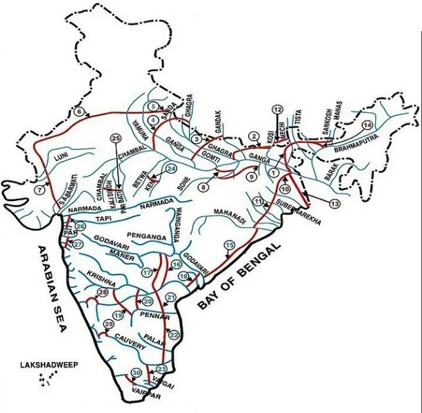
Indian river interlinking: an illustrative reference to proposed basin connections.
Credit: Nilesh shukla · CC BY-SA 4.0 · sourceResized and converted to WebP; uncropped.
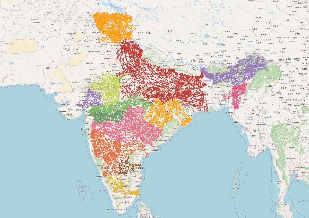
Map study
India river basins: distinguish watershed divides from state boundaries; compare east-flowing and west-flowing drainage.
- Read the source legend, scale and reference period before comparing regions.
- Connect spatial patterns to the processes discussed in this topic; this map is a study reference, not live operational data.
Credit: Heinz OSM · ODbL · sourceConverted to WebP on an opaque white background; proportionally resized without cropping. Original cartography and legend retained.
1. Concept and geographical rationale
River interlinking is the planned transfer of water from one drainage basin or sub-basin to another. A drainage basin is the area drained by a river and its tributaries, bounded by a watershed or drainage divide. Unlike an ordinary canal distributing water within a command area, an inter-basin link crosses a drainage divide. Transfers may use gravity where elevations permit; elsewhere, lift irrigation, tunnels and substantial electricity inputs are required.
India’s rainfall is highly seasonal and spatially uneven. Much of the country receives most of its annual precipitation during the southwest monsoon, while water demand persists throughout the year. Flooding in some regions can coincide with drought elsewhere. This contrast supports the argument for storing monsoon flows and redistributing part of them. However, simultaneous flooding and drought do not automatically establish that an economically and ecologically transferable surplus exists.
The basin, rather than the state, is the appropriate hydrological unit. A basin labelled surplus today may face shortages after changes in cropping patterns, urban demand, groundwater use or climate. Consequently, dependable yield and seasonal water balances matter more than average annual discharge alone.
- Inter-basin transfer differs from intrabasin redistribution, although both may involve canals and reservoirs.
- Water abundance at a flood peak is not equivalent to reliable year-round availability.
Timeline
1980
National Perspective Plan for water resources development prepared.
1982
National Water Development Agency established.
2012
Supreme Court directed constitution of a special committee on river interlinking.
March 2021
Union government, Madhya Pradesh and Uttar Pradesh signed the agreement for implementing Ken–Betwa.
December 2021
Union Cabinet approved implementation of the Ken–Betwa Link Project with central support.
2. National Perspective Plan and major link geography
The National Perspective Plan, prepared in 1980, has Himalayan and Peninsular components. The National Water Development Agency, under the Ministry of Jal Shakti, investigates proposed transfers and prepares feasibility reports and detailed project reports. Identification of a link is only a planning milestone: it does not imply agreement among states, statutory approval, construction or operation.
The Himalayan component envisages storage and transfer arrangements involving the Ganga–Brahmaputra river systems and associated basins. These proposals face difficult terrain, sedimentation, seismic hazards, interstate allocation questions and, in several cases, cooperation with neighbouring countries. Himalayan rivers receive varying contributions from rainfall, snowmelt and glacier melt; they should not be treated as uniformly glacier-fed.
The Peninsular component includes the Mahanadi–Godavari–Krishna–Pennar–Cauvery transfer concept, west-flowing river proposals and links such as Ken–Betwa. Many peninsular rivers have strongly monsoonal flows. Transfers across the Western Ghats or towards higher plateaus can involve major engineering and ecological constraints. The frequently quoted programme-level potential of about 35 million hectares of additional irrigation and roughly 34,000 MW of hydropower represents planning projections, not benefits already achieved.
- Par–Tapi–Narmada concerns western India; Damanganga–Pinjal is associated with augmenting water supply for the Mumbai region.
- Map the donor basin, receiving basin, intervening drainage divide and concerned states for each important link.
From proposed link to accountable operation
- 1. Assess basin water balances, dependable yield and environmental requirements
- 2. Compare transfer options with local supply and demand-management alternatives
- 3. Prepare feasibility studies and a detailed project report
- 4. Negotiate interstate or international sharing and operating arrangements
- 5. Obtain applicable clearances, arrange rehabilitation and secure finance
- 6. Construct, operate and monitor water deliveries, costs and ecological outcomes
3. Expected benefits and hydrological limitations
Supporters emphasise irrigation expansion, drinking-water security, industrial supply and drought mitigation. Storage-backed transfers may stabilise agricultural production during dry spells and support multiple cropping. Some projects can generate hydropower, while others consume electricity for pumping. Navigation is possible only where channel depth, continuity and infrastructure permit; it is not an automatic benefit of a water-transfer canal.
Reservoirs may moderate selected flood peaks if they maintain adequate flood-storage space and follow suitable operating rules. Yet flood control cannot be equated with complete flood prevention. Extreme rainfall, overflowing tributaries, urban drainage failure and floodplain encroachment can cause inundation even where large reservoirs exist. Irrigation storage and flood cushioning can also create competing operational objectives.
A sound appraisal must examine flows in dry years, not merely average conditions. Monsoon failures can affect donor and recipient basins together, reducing transfer reliability precisely when demand is greatest. Evaporation, canal seepage, sedimentation and pumping costs influence net benefits. Canal seepage can recharge groundwater in some settings but may also cause waterlogging and salinity. Benefits therefore depend on local soils, drainage, operating rules and water-use efficiency.
- Differentiate gross water diverted from water effectively delivered and productively used.
- Assess cumulative effects of existing dams and proposed links across the entire basin.
| Link or transfer concept | Geographical association | Exam distinction |
|---|---|---|
| Ken–Betwa | Madhya Pradesh and Uttar Pradesh; Bundelkhand | Both rivers are Yamuna tributaries |
| Mahanadi–Godavari | East-flowing peninsular basins | Part of the proposed southward transfer chain |
| Godavari–Krishna | East-flowing basins draining to the Bay of Bengal | Distinguish individual state projects from NPP proposals |
| Par–Tapi–Narmada | Western India, involving Gujarat and Maharashtra | Associated with west-flowing river basins |
| Damanganga–Pinjal | Western India; Mumbai water-supply objective | Urban water supply is a major purpose |
4. Environmental and social concerns
River flows sustain floodplains, wetlands, fisheries, estuaries and deltas. Water and sediment reaching the sea are not simply wasted: they maintain coastal landforms, nutrient cycles and salinity balances. Large diversions can reduce freshwater inflows to estuaries, encourage saline intrusion and alter downstream habitats. Dams trap sediment, potentially compounding delta erosion when combined with sand mining, subsidence and sea-level rise.
Reservoirs and canals can submerge forests, fragment wildlife habitats and alter fish migration. Inter-basin connections may facilitate the movement of invasive aquatic organisms or change water-quality conditions. Environmental flows must address seasonal variability and ecological functions rather than only a fixed minimum release. Climate change adds uncertainty by changing rainfall intensity, drought persistence and the reliability of historical flow estimates.
Land acquisition may displace villages and affect cultivators, forest-dependent communities and fishers. Impacts include loss of common property resources and livelihoods, not merely residential land. Appraisal should compare who receives irrigation or urban water with who bears displacement and ecological costs. Rehabilitation, livelihood restoration, applicable forest-rights requirements and meaningful consultation are integral project obligations.
- Environmental impact assessment should include downstream, cumulative and construction-related effects.
- Ken–Betwa illustrates the tension between regional water security and conservation around Panna Tiger Reserve.
5. Institutions, federalism and legal requirements
Water is primarily covered by Entry 17 of the State List, subject to Entry 56 of the Union List concerning regulation and development of interstate rivers and river valleys when Parliament declares Union control expedient in the public interest. Article 262 enables Parliament to provide for adjudication of interstate river-water disputes. The Inter-State River Water Disputes Act, 1956, provides the principal statutory framework for such adjudication.
Interlinking requires agreement on the quantity, timing, dependability and priority of transfers. States may contest the classification of a basin as surplus, especially when future irrigation or urban demand is considered. Downstream states can be affected even when a proposed canal lies elsewhere. Cross-border Himalayan proposals additionally require international cooperation and cannot be implemented solely through domestic administrative decisions.
Projects require applicable environmental, forest and wildlife approvals, along with land acquisition and rehabilitation processes. The EIA Notification, 2006, governs environmental appraisal of covered project categories. In 2012, the Supreme Court directed creation of a special committee to advance river interlinking; this did not remove project-specific legal requirements. Technical feasibility, statutory clearance, financial sanction and implementation remain distinct stages.
- National Water Policy, 2012, supports considering inter-basin transfers on their merits, with environmental, economic and social evaluation.
- Transparent hydrological data and enforceable operating arrangements are essential for durable interstate cooperation.
6. Balanced appraisal and complementary measures
River interlinking should be assessed project by project, not accepted or rejected as a single uniform intervention. A technically feasible link may still have high ecological costs or weak economic returns. Appraisal should test alternatives, account for energy and maintenance expenditure, evaluate distributional impacts and check whether projected agricultural demand reflects suitable cropping patterns.
Demand management and local water security remain essential. Measures include watershed treatment, tank restoration, rainwater harvesting, aquifer recharge where hydrogeologically suitable, wastewater reuse and improved irrigation scheduling. Micro-irrigation can reduce application losses, but basin-level savings are not guaranteed if farmers expand irrigated area or switch to more water-intensive crops. Groundwater extraction and surface-water transfers must therefore be planned together.
For Prelims, avoid absolute claims: not all links are gravity-based, not all generate power, and not all connect distant river systems. An operational state-led transfer is not necessarily a completed National Perspective Plan link. The strongest policy approach combines basin-scale evidence, realistic demand estimates, environmental safeguards and negotiated sharing arrangements.
- Evaluate reliability, affordability, ecological sustainability and equity together.
- Treat interlinking as one possible water-management instrument, not a universal cure for droughts and floods.
River Interlinking: Basin Transfers and Their Trade-offs
The supplied title and description directly identify India’s river-interlinking programme, making this image relevant to inter-basin water transfers. However, metadata alone cannot establish which links are represented, their alignment or their implementation status. India’s National Perspective Plan has Himalayan and peninsular components. Its central idea is to move water between selected basins through engineered connections; this is different from the natural joining of tributaries within a drainage basin.
Calling a basin “surplus” does not mean that its water is unused or permanently available for diversion. Transfer feasibility depends on seasonal flows, drought-year reliability, existing withdrawals, downstream needs and environmental flows. Because monsoon rainfall is strongly seasonal, storage and transfer timing matter as much as annual runoff. Potential irrigation, drinking-water and hydropower benefits must be weighed against displacement, habitat fragmentation, altered sediment transport and changes to downstream wetlands and deltas. Interstate agreements are crucial because hydrological basin boundaries do not coincide with state boundaries; some Himalayan proposals also involve transboundary considerations.
- Prelims distinction: a proposed link, an approved project, construction activity and an operational transfer are different stages. An illustrative image cannot establish current project status.
- Physical geography: gravity transfers require favourable elevation differences; pumping across divides raises energy requirements. Canal routes therefore depend on relief, not simply distance between rivers.
- Mains evaluation: compare interlinking with demand management, groundwater recharge and improved irrigation efficiency. Benefits require basin-level water accounting, credible ecological assessment and enforceable sharing arrangements.
Real-world case studies
Ken–Betwa: Bundelkhand water security and conservation
The project proposes transferring water from the Ken to the Betwa through Daudhan Dam and a link canal. It targets irrigation and drinking-water needs in drought-prone Bundelkhand across Madhya Pradesh and Uttar Pradesh. Its reservoir entails submergence within Panna Tiger Reserve, making habitat impacts, downstream flows and mitigation central issues. It demonstrates why an interstate agreement and infrastructure benefits must be examined alongside conservation and rehabilitation obligations.
Pattiseema: a lift-based Godavari–Krishna transfer
Commissioned in Andhra Pradesh in 2015, the Pattiseema Lift Irrigation Scheme pumps Godavari water into the Polavaram right main canal for conveyance towards the Krishna system. It illustrates how existing canal alignments can support inter-basin transfer, but also highlights pumping-energy requirements and dependence on available donor-river flows. It should not be confused with completion of the Polavaram multipurpose project or the entire national interlinking programme.
Previous year questions
UPSC Mains 2020 · GS-I
The interlinking of rivers can provide viable solutions to the multidimensional, interrelated problems of droughts, floods and interrupted navigation. Critically examine.
- Explain spatial and seasonal differences in water availability.
- Discuss irrigation reliability, selective flood moderation and conditional navigation benefits.
- Assess uncertain surplus estimates, ecological impacts, displacement and energy costs.
- Examine interstate cooperation and international dimensions.
- Conclude with project-specific evaluation and complementary demand management.
Practice questions
Practice MCQ 1
With reference to the Ken–Betwa Link Project, consider the following statements: 1. Both rivers are tributaries of the Yamuna. 2. The project concerns Madhya Pradesh and Uttar Pradesh. 3. The proposed Daudhan Dam is on the Betwa. Which statements are correct?
- A. 1 and 2 only
- B. 2 and 3 only
- C. 1 and 3 only
- D. 1, 2 and 3
Practice MCQ 2
Which of the following is the most appropriate basis for identifying transferable water surplus in a river basin?
- A. The highest flood discharge recorded at its mouth
- B. Average annual rainfall alone
- C. Dependable flows after accounting for demands, downstream obligations and environmental requirements
- D. The total volume of freshwater reaching the sea
Practice MCQ 3
Consider the following statements about inter-basin water transfers: 1. Every transfer can operate entirely by gravity. 2. Dams associated with transfers can reduce sediment delivery downstream. 3. Drought affecting both donor and recipient basins can weaken transfer reliability. Which statements are correct?
- A. 1 only
- B. 1 and 2 only
- C. 2 and 3 only
- D. 1, 2 and 3
Mains practice · A river basin’s water surplus is a planning assessment, not an immutable geographical fact. Discuss this statement in the context of river interlinking in India. Suggest safeguards for sustainable transfers. Answer in 250 words.
- Define surplus using dependable flows, demand and environmental requirements.
- Explain changes caused by urbanisation, cropping patterns, groundwater depletion and climate variability.
- Discuss seasonal mismatch and correlated droughts.
- Use Ken–Betwa to illustrate development–conservation trade-offs.
- Recommend open hydrological data, alternatives assessment, environmental flows and interstate operating rules.
- Integrate rehabilitation, demand management and adaptive monitoring.
Further reading
- NCERT, India: Physical Environment, Class XI, chapter on Drainage System.
- National Water Development Agency official website: National Perspective Plan and individual link reports.
- Ministry of Jal Shakti: annual reports and official material on interlinking of rivers.
- National Water Policy, 2012.
- Press Information Bureau: December 2021 Cabinet approval of the Ken–Betwa Link Project.
- India Code: Constitution of India and Inter-State River Water Disputes Act, 1956.
- https://commons.wikimedia.org/wiki/File:Indian_Rivers_Inter-link.png
Preparing for UPSC Civil Services? Get classroom teaching, answer-writing evaluation and mentorship at Pragnya IAS Academy, Ashok Nagar — see why aspirants choose us for IAS coaching in Hyderabad.