
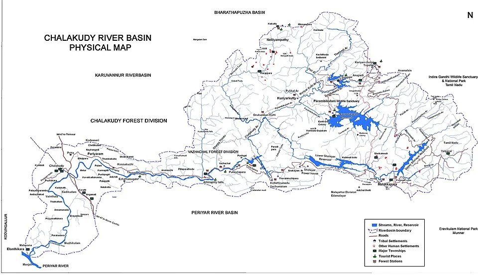
Chalakudy River basin map: an Indian example of west-flowing drainage.
Credit: Prajaneeshp (talk) · CC BY-SA 3.0 · sourceResized and converted to WebP; uncropped.
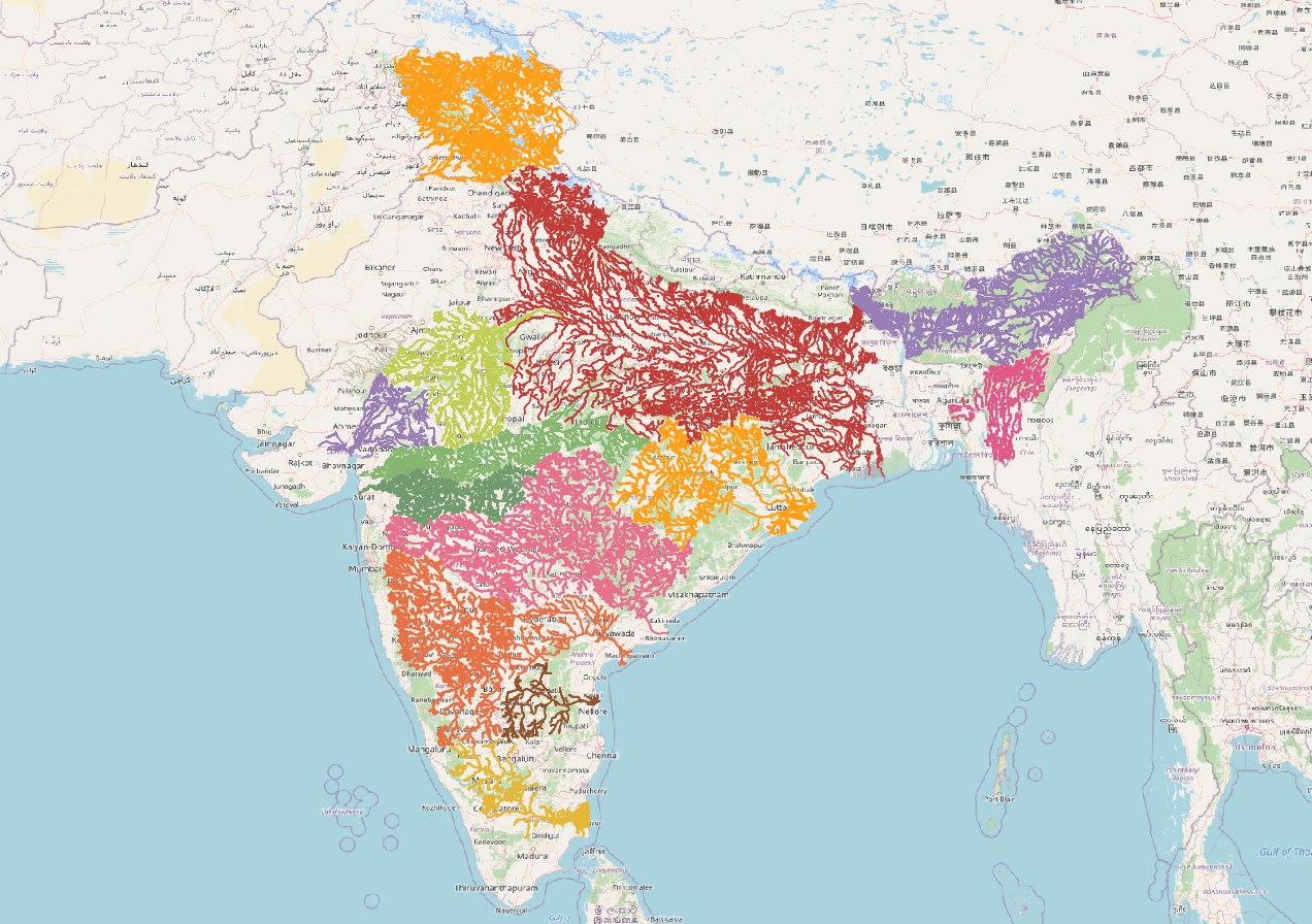
Map study
India river basins: distinguish watershed divides from state boundaries; compare east-flowing and west-flowing drainage.
- Read the source legend, scale and reference period before comparing regions.
- Connect spatial patterns to the processes discussed in this topic; this map is a study reference, not live operational data.
Credit: Heinz OSM · ODbL · sourceConverted to WebP on an opaque white background; proportionally resized without cropping. Original cartography and legend retained.
1. Basin concepts and drainage patterns
A river basin, or drainage basin, is the area from which surface runoff reaches a common river system and outlet. Its boundary is a drainage divide or water divide, usually following ridges and other elevated land. A tributary joins a larger stream, whereas a distributary branches away from the main channel, commonly near a delta. A confluence is the meeting point of streams. Groundwater movement does not always follow surface-basin boundaries because aquifers are controlled by subsurface geological conditions.
Catchment and drainage basin are often used interchangeably. In Indian planning, watershed commonly denotes a smaller hydrological unit within a basin, although terminology varies internationally. Basins can be subdivided into sub-basins and micro-watersheds for soil conservation, recharge and local water budgeting. An exorheic basin ultimately drains to the sea; an endorheic basin terminates within the landmass, usually in a lake, wetland or depression where evaporation and infiltration remove water.
Drainage patterns provide clues about relief and rock structure. Dendritic networks resemble tree branches and commonly develop over relatively uniform rocks. Trellis drainage occurs where alternating resistant and softer formations guide streams; rectangular drainage reflects joints and faults. Radial drainage develops outward from an elevated centre, while centripetal drainage converges towards a depression. Pattern describes the spatial arrangement of streams, not whether their water is perennial or seasonal.
- Drainage density is total stream length divided by basin area; it is influenced by permeability, vegetation, slope and rainfall.
- Antecedent rivers maintain their courses while the land rises; superimposed drainage inherits a course established on an earlier cover of rocks.
- River capture transfers drainage from one basin to another through processes such as headward erosion.
2. Himalayan and northern river basins
The Indus, Ganga and Brahmaputra are major transboundary Himalayan river systems. Their flows reflect both precipitation and snow or glacier melt, but the proportions differ across basins and seasons. They are generally perennial, carry substantial sediment and build extensive alluvial plains. Young mountain terrain, steep gradients, landslides and intense rainfall create major erosion and flood hazards. Himalayan rivers are not supplied exclusively by glaciers: monsoon rainfall is particularly important in the Ganga and Brahmaputra systems.
The Indus rises in Tibet near Lake Mapam Yumco, also called Manasarovar, and flows through Ladakh before entering Pakistan. Its major eastern tributaries are the Jhelum, Chenab, Ravi, Beas and Sutlej. The Beas joins the Sutlej at Harike in Punjab. The Chenab forms from the Chandra and Bhaga near Tandi in Himachal Pradesh. The Sutlej enters India near Shipki La. Distinguishing tributaries of the Indus system from those of the Ganga is a recurring map-based examination requirement.
The Ganga takes its name at Devprayag, where the Bhagirathi and Alaknanda meet. Major tributaries include the Yamuna, Ramganga, Gomti, Ghaghara, Gandak, Kosi and Son. The Yamuna joins the Ganga at Prayagraj, while the Chambal, Betwa and Ken join the Yamuna. The Brahmaputra is called Yarlung Tsangpo in Tibet and Siang or Dihang in Arunachal Pradesh; after receiving the Dibang and Lohit, it traverses Assam. The Ganga–Brahmaputra–Meghna system forms an extensive delta shared by India and Bangladesh.
- Left and right banks are identified while facing downstream, not by looking northward on a map.
- The Son is a right-bank tributary of the Ganga; the Ghaghara, Gandak and Kosi enter from the northern side.
- The Teesta joins the Brahmaputra, known as the Jamuna in Bangladesh, rather than directly joining the Ganga.
How to analyse a river basin
- 1. Locate the source, outlet and surrounding drainage divides.
- 2. Trace the main river, tributaries and confluences.
- 3. Identify relief, geological controls and drainage pattern.
- 4. Assess rainfall, seasonal flow, groundwater and storage.
- 5. Map settlements, irrigation, dams and ecological assets.
- 6. Evaluate hazards and upstream–downstream governance needs.
3. Peninsular and inland drainage
Peninsular drainage developed largely over an ancient, relatively stable geological framework. Many rivers have broad valleys, comparatively fixed courses and strong seasonal variation linked to the monsoon. They are often described as seasonal, but this does not mean every Peninsular river dries up each summer. Groundwater discharge, rainfall distribution and reservoir operations influence dry-season flow. The broad eastward slope of the plateau explains why most large Peninsular systems reach the Bay of Bengal.
The Mahanadi rises near Sihawa in Chhattisgarh and flows through Odisha. The Godavari rises near Trimbakeshwar in Maharashtra; important tributaries include the Pranhita, Indravati, Manjira and Sabari. The Pranhita drains the combined waters of the Wardha–Wainganga system. The Krishna rises near Mahabaleshwar, with the Bhima and Tungabhadra as major tributaries. The Kaveri rises at Talakaveri in Karnataka’s Brahmagiri Hills; its tributaries include the Kabini, Hemavati, Bhavani and Amaravati.
The Narmada rises near Amarkantak and flows west between the Vindhya and Satpura ranges, largely through a structurally controlled rift valley. The Tapi rises near Multai in Madhya Pradesh and also flows west through a structural trough. Both enter the Gulf of Khambhat and have estuarine mouths rather than extensive deltas. Short western coastal rivers include the Mandovi, Zuari, Sharavathi and Periyar. In arid northwestern India, some streams terminate inland; the Luni flows towards the Rann of Kachchh, while Sambhar Lake occupies a closed drainage depression.
- The Mahanadi, Godavari, Krishna and Kaveri build important east-coast deltas.
- West-flowing does not automatically mean rift-valley drainage: the Sabarmati, Mahi and numerous coastal rivers also flow west.
- River-mouth form depends on sediment supply, waves, tides and coastal configuration, not drainage direction alone.
| River | Source or naming point | Selected tributaries | Outlet |
|---|---|---|---|
| Ganga | Devprayag: Bhagirathi–Alaknanda confluence | Yamuna, Ghaghara, Gandak, Kosi, Son | Bay of Bengal through a shared deltaic system |
| Brahmaputra | Tibetan Plateau | Dibang, Lohit, Subansiri, Manas | Bay of Bengal through Bangladesh |
| Godavari | Trimbakeshwar, Maharashtra | Pranhita, Indravati, Manjira, Sabari | Bay of Bengal |
| Krishna | Near Mahabaleshwar, Maharashtra | Bhima, Tungabhadra, Ghataprabha | Bay of Bengal |
| Narmada | Near Amarkantak, Madhya Pradesh | Tawa, Hiran | Gulf of Khambhat |
| Kaveri | Talakaveri, Karnataka | Kabini, Hemavati, Bhavani | Bay of Bengal |
4. Basin water balance and hazards
Basin water availability depends on precipitation, evapotranspiration, runoff and changes in storage. Storage includes soil moisture, groundwater, lakes, wetlands, reservoirs and snow. Annual runoff is not equivalent to water reliably available throughout the year. India’s concentrated monsoon creates a mismatch between wet-season supply and dry-season demand. Water-resource estimates must therefore distinguish average availability, seasonal dependability, usable storage, water quality and ecological requirements.
Land-use changes alter basin responses. Deforestation, road cutting and exposed slopes can increase erosion; urban surfaces accelerate storm runoff and reduce local infiltration. Floodplain occupation increases exposure even where flood magnitude remains unchanged. Excessive groundwater withdrawal may reduce baseflow to rivers. Dams moderate some floods and provide irrigation or electricity, but they also modify sediment transport, aquatic connectivity and downstream flow timing. Delta subsidence, coastal erosion and saline intrusion require attention to both upstream management and coastal processes.
- Flood and drought can occur within the same basin because rainfall, storage and access to water are uneven.
- Environmental flows concern the quantity, timing and quality of water needed to sustain river ecosystems and dependent livelihoods.
- A basin assessment should examine upstream–downstream effects rather than treating each project in isolation.
5. Governance and examination approach
Basin-based planning seeks to coordinate land, surface water, groundwater and ecosystem management across administrative boundaries. Under the Constitution, water appears in State List Entry 17, subject to Union List Entry 56 concerning regulation and development of inter-state rivers and river valleys when Parliament declares Union control expedient in the public interest. Article 262 enables parliamentary provision for adjudicating inter-state water disputes. The Inter-State River Water Disputes Act, 1956 and River Boards Act, 1956 are important statutory reference points.
Effective management requires shared data, flood forecasting, pollution control, demand management and coordination among states. The Central Water Commission and India-WRIS provide useful basin information; the National Water Policy, 2012 supports integrated water-resources management with the river basin or sub-basin as the planning unit. For Prelims, trace each river from source to mouth, identify tributary hierarchies and distinguish states traversed by the main channel from states containing part of its catchment. Also separate a basin’s total transboundary area from its area within India.
- Study river–dam pairs alongside basin maps: Hirakud–Mahanadi, Nagarjuna Sagar–Krishna and Sardar Sarovar–Narmada.
- Avoid assuming that rivers originating near one another belong to the same basin: the Narmada and Son drain in different directions.
- Use physical maps to connect divides, plateaus, mountain passes, confluences and river mouths.
Chalakudy Basin: Relief, Drainage Divides and Water Management
The metadata identifies this image as a map of the Chalakudy River basin, making it directly relevant to river-basin geography. The Chalakudy drains part of the Western Ghats and flows westward through Kerala. Its basin offers a useful contrast with the extensive east-flowing Peninsular systems. A basin includes all land contributing runoff to a river and its tributaries, not merely the river channel or adjoining floodplain. Its boundary follows drainage divides, usually elevated terrain separating flows towards different river systems.
For Indian geography, this example connects relief with drainage direction and basin-scale planning. The Western Ghats help organise drainage towards the Arabian Sea and the Bay of Bengal, but individual river courses also reflect local slopes and geological structure. Monsoon rainfall, vegetation, reservoirs and water withdrawals influence runoff within a basin. Upstream interventions can affect downstream flow timing, sediment movement and ecosystems, so management must consider the connected catchment rather than isolated administrative units. The supplied metadata does not establish the map’s scale, boundary accuracy, tributary labels or reservoir coverage; these require verification before using it for detailed location-based revision.
- Distinguish basin, watershed and divide: watershed can denote either a catchment or its separating ridge, depending on usage.
- Avoid equating basin boundaries with state boundaries; hydrological and administrative units need not coincide.
- West-flowing does not mean Himalayan: Chalakudy is Peninsular, illustrating why drainage direction and physiographic origin are separate classifications.
Real-world case studies
Kosi embankment breach, 2008
In August 2008, the Kosi breached its eastern embankment near Kusaha in Nepal and diverted into an older course, causing devastating flooding in Bihar. The event illustrated channel instability and sediment-related risks on an alluvial megafan. It underlined the need for transboundary monitoring, embankment maintenance, floodplain planning and warning systems rather than reliance on embankments alone.
Cauvery basin coordination
The Cauvery basin supports irrigation, cities and ecosystems across Karnataka, Tamil Nadu, Kerala and Puducherry. Following the Supreme Court’s February 2018 judgment, the Cauvery Water Management Authority and Cauvery Water Regulation Committee were constituted in 2018. The basin demonstrates why rainfall variability, reservoir operations and seasonal release schedules are central to inter-state water management.
Previous year questions
UPSC Prelims 2013
The Narmada flows west while most other large Peninsular rivers flow east. Consider the suggested reasons: 1. It occupies a linear rift valley. 2. It flows between the Vindhyas and Satpuras. 3. The land slopes westward from Central India. Which correctly explains its westward flow?
- A. 1 only
- B. 2 and 3 only
- C. 1 and 3 only
- D. None of the above
Practice questions
Practice MCQ 1
Consider the following pairs: 1. Indravati — Godavari basin; 2. Betwa — Yamuna sub-basin; 3. Kabini — Krishna basin. Which pairs are correctly matched?
- A. 1 only
- B. 1 and 2 only
- C. 2 and 3 only
- D. 1, 2 and 3
Practice MCQ 2
Which statement best describes an endorheic basin?
- A. It drains exclusively through underground channels.
- B. Its river necessarily remains dry throughout the year.
- C. Its drainage terminates inland rather than reaching the ocean.
- D. Its streams radiate outward from a central mountain.
Practice MCQ 3
Consider the following statements: 1. The Western Ghats separate many Arabian Sea coastal catchments from east-flowing Peninsular basins. 2. Every west-flowing Peninsular river occupies a rift valley. 3. A state can contain part of a river’s basin even if the main river does not traverse that state. Which statements are correct?
- A. 1 and 2 only
- B. 2 only
- C. 1 and 3 only
- D. 1, 2 and 3
Mains practice · Why is the river basin a more appropriate unit than administrative boundaries for water-resource planning in India? Discuss with examples. Answer in 250 words.
- Define a basin as an interconnected hydrological unit.
- Explain upstream–downstream links involving runoff, sediment, pollution and reservoir releases.
- Integrate groundwater, floodplains, wetlands and environmental flows.
- Use the Kosi for transboundary flood risks and the Cauvery for inter-state allocation.
- Discuss fragmented institutions, competing demands and data-sharing constraints.
- Recommend cooperative basin planning, demand management and climate-resilient operations.
Further reading
- NCERT, India: Physical Environment, Class XI, chapter on Drainage System.
- NCERT, Contemporary India–I, Class IX, chapter on Drainage.
- Central Water Commission and ISRO, River Basin Atlas of India, 2012.
- India-WRIS portal: basin maps and water-resources information.
- Ministry of Jal Shakti, National Water Policy, 2012.
- India Code: Inter-State River Water Disputes Act, 1956 and River Boards Act, 1956.
- https://commons.wikimedia.org/wiki/File:Chalakudy_River_Basin_Map.jpg
Preparing for UPSC Civil Services? Get classroom teaching, answer-writing evaluation and mentorship at Pragnya IAS Academy, Ashok Nagar — see why aspirants choose us for IAS coaching in Hyderabad.