

This image is taken from a bridge on Indira Gandhi Canal at Lohgarh village (in Mandi Dabwali tehsil, Sirsa district, Haryana). It is the place where waters of Indira Gandhi Canal flow from Punjab int
Credit: Shemaroo at English Wikipedia (Sivendersingh, email:-Sivendersingh@gmail.Com) · CC BY-SA 3.0 · source

Drip irrigation tubes for the use in banana farm at Chinawal village, India
Credit: ABHIJEET · CC BY-SA 3.0 · source
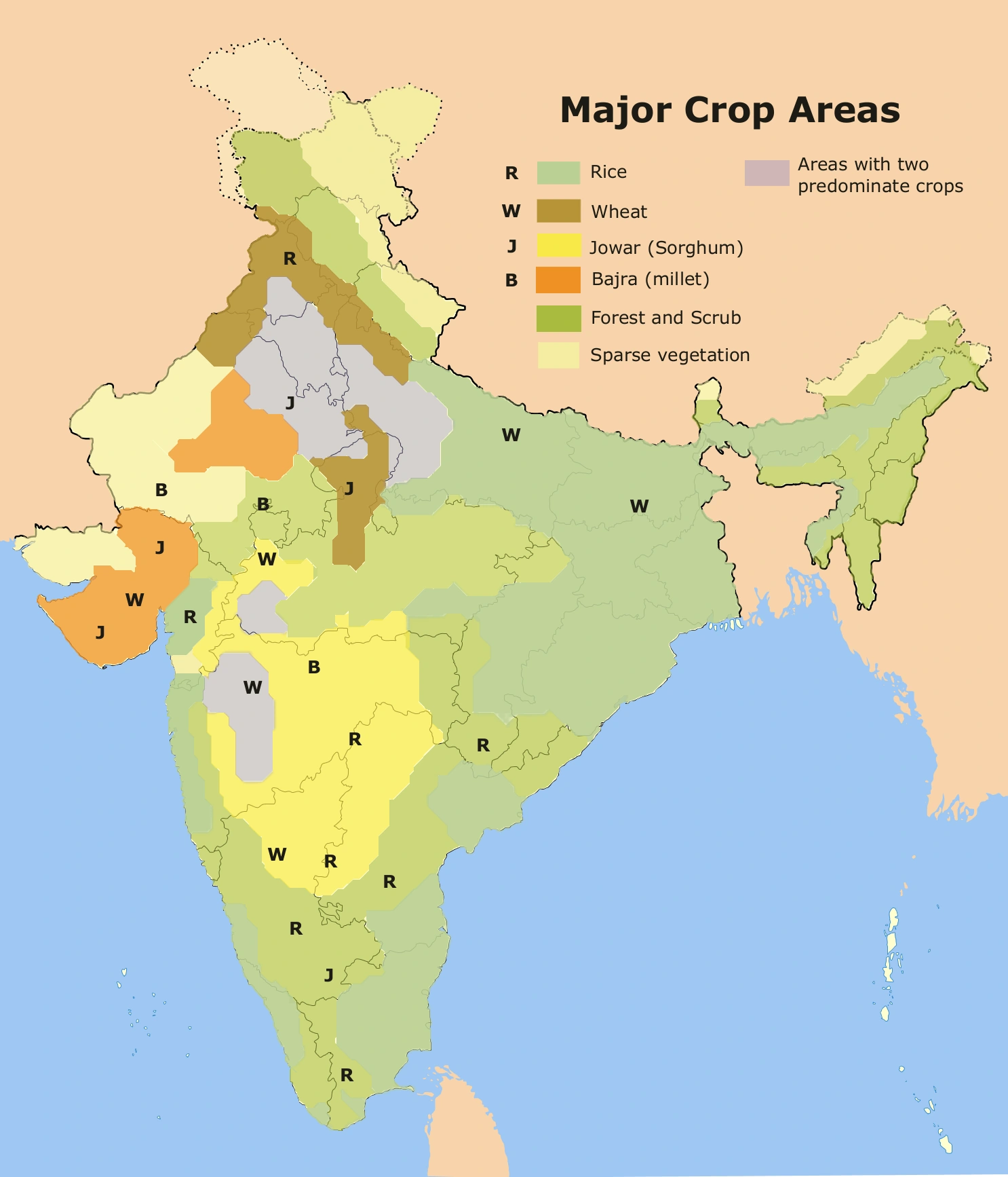
Map study
Major crop regions of India: relate crop belts to rainfall, soils, temperature and irrigation. Schematic historical reference, not current production rankings.
- Read the source legend, scale and reference period before comparing regions.
- Connect spatial patterns to the processes discussed in this topic; this map is a study reference, not live operational data.
Credit: Amog · CC BY-SA 2.5 · sourceConverted to WebP on an opaque white background; proportionally resized without cropping. Original cartography and legend retained.
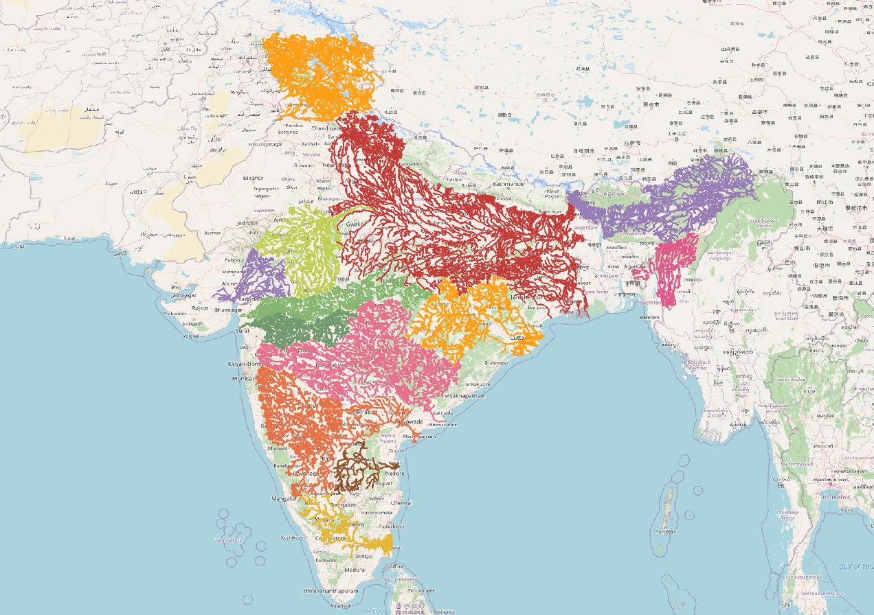
Map study
India river basins: distinguish watershed divides from state boundaries; compare east-flowing and west-flowing drainage.
- Read the source legend, scale and reference period before comparing regions.
- Connect spatial patterns to the processes discussed in this topic; this map is a study reference, not live operational data.
Credit: Heinz OSM · ODbL · sourceConverted to WebP on an opaque white background; proportionally resized without cropping. Original cartography and legend retained.
1. Agricultural importance and basic concepts
India receives much of its annual rainfall during the southwest monsoon, but its onset, withdrawal and within-season distribution vary. Irrigation bridges dry spells during kharif, supplies water for rabi crops and permits summer cultivation where water is available. Even relatively wet regions need supplemental irrigation when rainfall does not coincide with critical crop stages. Thus, annual rainfall totals alone do not determine irrigation requirements.
Reliable irrigation enables multiple cropping, adoption of high-yielding varieties and more effective use of fertilisers. It helped sustain the Green Revolution, particularly the rice–wheat system of northwestern India. Nevertheless, assured water can encourage unsuitable crop choices. Water-intensive paddy and sugarcane in water-stressed regions illustrate the importance of matching crops to agroclimatic conditions rather than treating irrigation expansion as an unconditional benefit.
Net irrigated area measures the physical area irrigated at least once during a year. Gross irrigated area includes repeated irrigation of the same land under successive crops. Irrigation intensity is gross irrigated area divided by net irrigated area, multiplied by 100. Culturable command area is the cultivable part of the area that an irrigation system can serve; it is not necessarily the area actually irrigated.
2. Sources and their geographical distribution
Canal irrigation is favoured by extensive plains, relatively gentle slopes and dependable river supplies. Diversion structures or storage reservoirs feed networks of main canals, distributaries and field channels. The northern plains and several peninsular river deltas have important canal commands. Perennial canals receive regulated supplies, whereas traditional inundation canals depend on high river stages and are less dependable.
Wells and tube wells provide decentralised irrigation that farmers can schedule according to crop needs. Thick alluvial aquifers and productive groundwater reserves explain their prominence in the Indo-Gangetic plains. Dug wells also occur widely in peninsular India, but groundwater there is often stored in weathered and fractured hard rock. Well yields can consequently vary sharply over short distances, and deeper drilling does not guarantee a dependable supply.
Tanks store local runoff behind embankments and are especially characteristic of peninsular landscapes, including Tamil Nadu, Karnataka and Telangana. Undulating terrain, natural depressions and seasonal streams favour these systems. Tanks may support irrigation, livestock, fisheries and groundwater recharge. Encroachment, siltation and disrupted feeder channels reduce their usefulness. Lift irrigation, meanwhile, raises water from rivers, reservoirs or other sources to higher ground and requires energy for pumping.
Planning sustainable irrigation
- 1. Assess rainfall, soil, aquifer and dependable surface-water supply.
- 2. Estimate crop water requirements and critical growth stages.
- 3. Choose suitable crops, sources and application methods.
- 4. Provide drainage, maintenance and equitable distribution.
- 5. Monitor groundwater, soil moisture and actual water consumption.
- 6. Adjust cropping area and water allocations to resource availability.
3. Application methods and water-use efficiency
Surface irrigation distributes water over fields through flooding, basins, borders or furrows. It is generally inexpensive to establish, but poor land levelling and uncontrolled flows can cause uneven watering, runoff and deep percolation. Furrows are suitable for many row crops because water moves along channels between crop rows. Laser land levelling can improve uniformity and reduce unnecessary application, especially in irrigated plains.
Sprinkler irrigation applies pressurised water as artificial rainfall. It is useful on undulating land and light-textured soils where conventional surface irrigation may be difficult. However, wind can distort distribution, evaporation can increase losses, and pressure requirements create energy costs. Water quality also matters because saline water sprayed on leaves can damage sensitive crops.
Drip irrigation supplies frequent, small quantities near the root zone through emitters. It is particularly useful for orchards, vegetables and widely spaced crops. Fertigation introduces soluble fertilisers through the irrigation system. Benefits depend on proper design, filtration, maintenance and scheduling; clogged emitters and unsuitable operating pressure reduce performance. Micro-irrigation therefore requires continuing technical support rather than equipment installation alone.
Higher field-level efficiency does not automatically produce equivalent basin-level water savings. Some seepage and percolation return to aquifers or downstream channels. Farmers may also use water saved per hectare to expand irrigation. Sustainable assessment must therefore consider consumptive use, return flows and crop area, while recognising that seepage can be harmful where it causes waterlogging or mobilises salts.
| Category | Criterion or meaning | Important distinction |
|---|---|---|
| Major project | Culturable command area above 10,000 hectares | Classification is not based on reservoir capacity. |
| Medium project | Culturable command area above 2,000 and up to 10,000 hectares | Uses the same command-area criterion. |
| Minor scheme | Culturable command area up to 2,000 hectares | Includes both groundwater and surface-water schemes. |
| Micro-irrigation | Localised or controlled application, especially drip and sprinkler | An application technology, not a command-area project class. |
4. Environmental stresses and management responses
Groundwater depletion occurs when abstraction persistently exceeds replenishment. Intensive pumping for irrigation, encouraged in some areas by subsidised electricity and water-intensive crop incentives, has lowered groundwater levels in parts of Punjab, Haryana, Rajasthan and other states. Consequences include rising pumping costs, drying shallow wells and unequal access: farmers able to finance deeper borewells may outcompete poorer users.
Waterlogging develops when the water table rises sufficiently to restrict aeration in the crop root zone. Canal seepage, excessive irrigation and inadequate drainage can contribute. In arid and semi-arid commands, capillary movement brings dissolved salts towards the surface, where evaporation concentrates them. Salinity impairs crop water uptake; sodicity involves excessive exchangeable sodium and can damage soil structure. The two problems require diagnosis rather than identical treatment.
Responses include surface and subsurface drainage, suitable leaching where drainage permits, conjunctive use of surface water and groundwater, and crop diversification. Gypsum can reclaim sodic soils under appropriate conditions, but it is not a universal remedy for all salt-affected land. Irrigation scheduling should consider soil moisture, crop growth stage and weather. At the command scale, equitable deliveries to tail-end farmers and maintenance of distributaries are as important as new storage construction.
5. Institutions, schemes and examination linkages
Water is primarily a State List subject under Entry 17, subject to Union powers concerning interstate rivers and river valleys under Entry 56. Irrigation development therefore involves state departments, central assistance and interstate coordination. Water User Associations can support participatory irrigation management through local distribution, maintenance and conflict resolution, although their effectiveness depends on genuine authority, finance and inclusive representation.
Pradhan Mantri Krishi Sinchayee Yojana, launched in 2015, seeks to improve irrigation access and water-use efficiency. Its architecture has included the Accelerated Irrigation Benefits Programme, Har Khet Ko Pani, watershed development and Per Drop More Crop. From 2022–23, Per Drop More Crop has been implemented under Rashtriya Krishi Vikas Yojana. Scheme names should therefore be read with their administrative period rather than assumed to have an unchanged structure.
Atal Bhujal Yojana promotes community-led sustainable groundwater management in selected water-stressed areas of seven states. The Central Ground Water Board assesses groundwater resources, while the Central Water Commission performs major surface-water planning and technical functions. For Prelims, connect irrigation with aquifer geology, river basins, cropping seasons, soil degradation and energy use. Distinguish irrigation potential created from potential utilised: unfinished field channels, poor maintenance and unreliable supplies can leave infrastructure underused.
Real-world case studies
Indira Gandhi Canal command, Rajasthan
The canal conveys water from the Harike headworks towards northwestern Rajasthan, enabling cultivation in an arid region. Parts of its command have also experienced waterlogging and salinity. It illustrates why irrigation expansion must be accompanied by drainage, controlled application and cropping patterns appropriate to desert environments.
Mission Kakatiya, Telangana
Launched in 2015, Mission Kakatiya focuses on restoring minor irrigation tanks through measures such as desilting, bund strengthening and feeder-channel repair. It highlights the interconnected functions of traditional tanks: irrigation storage, groundwater recharge and local livelihoods. Sustained benefits require catchment protection and recurring maintenance.
Previous year questions
No source-linked PYQ is available here yet. Use the practice questions below.
Practice questions
Practice MCQ 1
A farm of 100 hectares is entirely irrigated during kharif, and 60 hectares of the same farm are irrigated during rabi. What is its irrigation intensity?
- A. 60%
- B. 100%
- C. 160%
- D. 200%
Practice MCQ 2
Consider the following statements: 1. A minor irrigation scheme may use groundwater or surface water. 2. Drip irrigation necessarily reduces total basin-level water consumption. 3. Excessive canal irrigation without adequate drainage can contribute to soil salinity. Which statements are correct?
- A. 1 and 2 only
- B. 1 and 3 only
- C. 2 and 3 only
- D. 1, 2 and 3
Practice MCQ 3
Which condition best explains the importance of tank irrigation in several parts of peninsular India?
- A. Uniformly thick and highly productive alluvial aquifers
- B. Year-round snowmelt supplying local streams
- C. Undulating terrain and depressions suitable for storing seasonal runoff
- D. Complete absence of groundwater resources
Mains practice · Expanding irrigation infrastructure is necessary but insufficient for agricultural water security in India. Discuss. Suggest measures for sustainable and equitable irrigation management. (250 words)
- Explain monsoon variability, protective irrigation and multiple cropping.
- Examine groundwater depletion, inefficient distribution, waterlogging and unequal access.
- Distinguish field-level efficiency from basin-level water savings.
- Recommend crop diversification, micro-irrigation, drainage and conjunctive use.
- Include tank restoration, aquifer-based water budgeting and empowered Water User Associations.
- Align electricity and crop incentives with water availability and monitor outcomes.
Further reading
- NCERT, India: People and Economy, Class XII: Water Resources; Land Resources and Agriculture.
- Ministry of Jal Shakti, Sixth Census of Minor Irrigation Schemes, reference year 2017–18.
- Central Ground Water Board, National Compilation on Dynamic Ground Water Resources of India.
- Central Water Commission, Water and Related Statistics.
- Official PMKSY and Department of Agriculture and Farmers Welfare guidelines on Per Drop More Crop.
Preparing for UPSC Civil Services? Get classroom teaching, answer-writing evaluation and mentorship at Pragnya IAS Academy, Ashok Nagar — see why aspirants choose us for IAS coaching in Hyderabad.