

Sand dunes in the Namib-Naukluft National Park, Namibia. Older dunes are reddish and larger, newer dunes are yellow-brown.
Credit: Yathin S Krishnappa · CC BY-SA 3.0 · source

The famous mushroom shaped formation in the white desert, Egypt.
Credit: Asgalal · CC BY-SA 4.0 · source
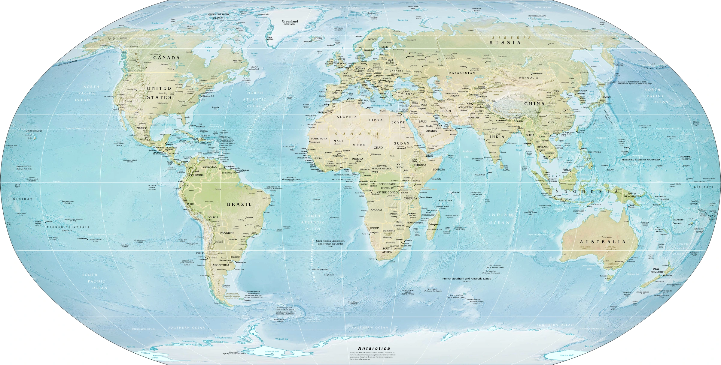
Map study
World physical relief: locate major mountain belts, plains and ocean basins. Regional orientation, not a detailed local landform survey.
- Read the source date and legend; distinguish territory, influence and geographic location.
- Historical boundaries and reference memberships are not live political or operational data.
Credit: US Government; Central Intelligence Agency · Public domain · sourceConverted to WebP on an opaque white background; proportionally resized without cropping. Original cartography and legend retained.
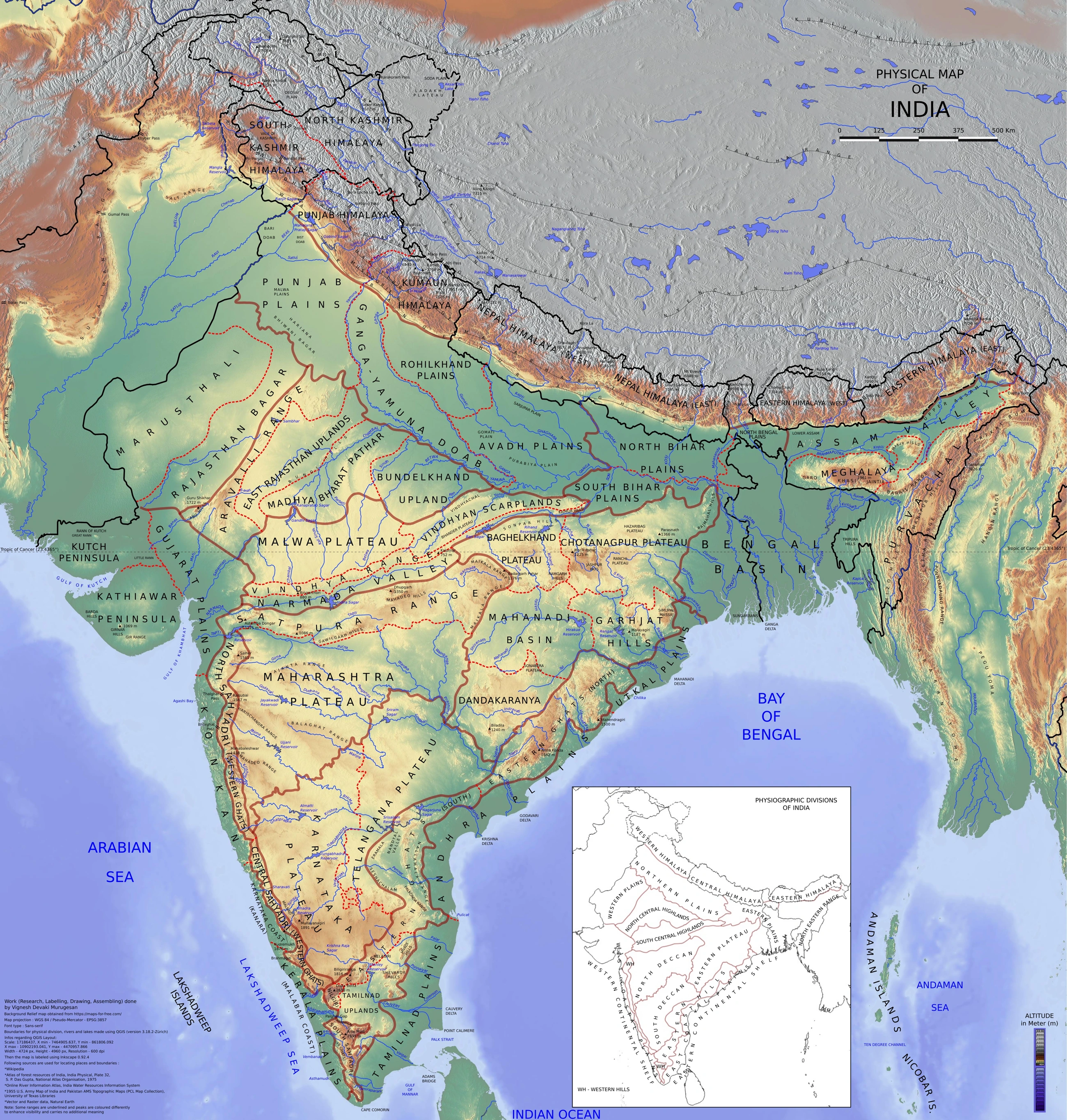
Map study
Physical divisions of India: locate mountains, plains, plateau, desert, coast and islands. Use regional relief to interpret landform processes; this is not a local geomorphological survey.
- Read the legend and reference date before interpreting regional patterns.
- Relate the map to the article’s topic; verify current administrative boundaries or data separately.
Credit: Vigneshdm1990 · CC BY-SA 4.0 · sourceConverted to WebP on an opaque white background; proportionally resized without cropping. Original cartography and legend retained.
1. Conditions and processes of aeolian activity
Aeolian processes are named after Aeolus, the keeper of winds in Greek mythology. Wind becomes an effective geomorphic agent where sediment is dry, loose and exposed, vegetation is sparse, and winds frequently exceed the threshold required to move particles. These conditions commonly occur in hot deserts, but also on beaches, river floodplains and cold, arid landscapes. Aridity encourages aeolian activity; it does not imply that wind created every desert landform.
Deflation is the lifting and removal of loose material from the ground. Abrasion is the wearing, polishing and grooving of rock by wind-driven particles, especially sand. Attrition refers to the wearing and fragmentation of transported grains through collisions. Wind alone is a relatively weak abrading agent; its sediment load supplies much of the cutting action.
Sediment movement depends on particle size, surface roughness, moisture and wind shear. Sand travels chiefly through saltation, a series of short hops. Impacting grains dislodge other grains or push coarser particles along the surface by creep. Fine silt and clay can remain suspended and move across continents and oceans. However, cohesive clay particles may initially resist entrainment more strongly than loose sand. Thus, the smallest particle is not necessarily the easiest to lift.
- Sediment sources include weathered rock, exposed lake beds, river deposits, beaches and glacial outwash.
- Vegetation traps grains, reduces near-surface wind velocity and helps stabilise sediment.
- Most sand transport occurs close to the ground; suspended dust can rise much higher.
2. Erosional landforms
Deflation hollows are depressions formed through the selective removal of loose sediment. They may enlarge until the surface reaches a resistant layer, becomes protected by coarse fragments, or encounters damp sediment near the water table. Some hollows contain seasonal water, but neither all desert basins nor all oases are products of deflation. An oasis depends fundamentally on accessible water.
Desert pavement is a tightly packed surface of gravel and stones over finer sediment. Selective removal of fines can leave a residual stone cover, but pavement formation is more complex than simple deflation: upward movement of stones and the accumulation of windblown dust beneath them can also contribute. The pavement acts as an armour that restricts further sediment loss.
Ventifacts are stones with polished, grooved or faceted surfaces produced by sand abrasion. A dreikanter is a characteristic three-edged or three-faced ventifact. Mushroom rocks or rock pedestals develop through differential erosion, often with stronger abrasion near the ground and contrasting resistance within the rock. Weathering and other processes may also help shape them.
Yardangs are elongated, streamlined ridges separated by grooves, commonly carved into relatively soft sediment or rock. Their long axes generally align with the effective erosive wind. Zeugens are traditionally described as table-like remnants in horizontally bedded rocks, where a resistant cap protects softer material beneath. The exam distinction is between streamlined, wind-aligned yardangs and cap-protected zeugens; actual landscapes may record several interacting processes.
Dune migration under a dominant wind
- 1. Wind exceeds the threshold for sand movement
- 2. Saltation and creep carry grains up the stoss slope
- 3. Sand accumulates near the crest
- 4. Grains avalanche down the leeward slip face
- 5. Repeated transfer shifts the dune downwind
3. Depositional landforms and dune morphology
Deposition occurs when wind transport capacity falls or grains are intercepted by obstacles. Sand may accumulate as sheets, ripples or dunes. A dune typically has a relatively gentle windward stoss slope and a steeper leeward slip face. Grains climb the stoss slope and avalanche down the slip face when its stability limit is exceeded. Dry sand commonly maintains slip-face angles around 30–34 degrees, although grain properties and moisture cause variation.
Barchans are isolated crescent-shaped dunes associated with limited sand supply, relatively firm ground and a dominant wind direction. Their horns point downwind because thinner margins advance faster than the central body. Where sand becomes more abundant, crescentic dunes may connect into ridges. Transverse dunes form broadly perpendicular to the resultant sand-transport direction, usually under abundant sediment supply and predominantly unidirectional winds.
Longitudinal or linear dunes are long ridges broadly aligned with the resultant sand-transport direction. Many develop under winds from two dominant directions, so they should not automatically be interpreted as products of a single wind. Star dunes have several radiating arms and multiple slip faces; they reflect multidirectional winds and substantial sand accumulation, often growing vertically.
Parabolic dunes are U-shaped, with arms pointing upwind. Vegetation anchors their trailing arms while the central nose advances downwind. They are common in coastal and semi-arid settings and may develop from blowouts in vegetated sand. Dune shape therefore reflects interacting controls rather than wind direction alone: sediment availability, vegetation, topography and changes in the wind regime all matter.
| Dune type | Shape or orientation | Typical controlling conditions |
|---|---|---|
| Barchan | Crescent; horns downwind | Limited sand; dominant wind direction; sparse vegetation |
| Transverse | Ridges broadly across sand transport | Abundant sand; predominantly unidirectional winds |
| Longitudinal | Long ridges broadly along resultant transport | Often two dominant wind directions |
| Parabolic | U-shaped; arms upwind | Vegetation anchors trailing arms |
| Star | Several radiating arms and slip faces | Multidirectional winds; substantial sand supply |
4. Loess and the global distribution of aeolian landscapes
Loess is a blanket-like deposit dominated by windblown silt. Its source material may originate in deserts, river floodplains or glacially ground sediment. Extensive deposits occur on China's Loess Plateau, in central Europe and in the Mississippi–Missouri basin. Loess is commonly porous and weakly cemented, and can maintain steep faces when dry. On wetting or disturbance, however, some deposits become susceptible to collapse, gullying and slope failure.
Large sand-covered desert areas are called ergs or sand seas. Regs are stony or gravelly desert surfaces, while hamadas are predominantly rocky plateaus or exposed bedrock surfaces. These terms describe contrasting desert surfaces, not successive stages of a universal erosion cycle. Much of the world's desert area is not covered by dunes.
Prominent aeolian landscapes occur in the Sahara, Arabian deserts, Namib, central Asia and Australia. In India, the Thar Desert of western Rajasthan and adjoining Pakistan contains active and stabilised dunes and sandy plains. Monsoon seasonality, vegetation, grazing and cultivation influence sediment mobility. Coastal dunes, including those along parts of Tamil Nadu and Odisha, demonstrate that aeolian deposition is not confined to deserts.
5. Environmental significance and management
Aeolian erosion can remove fertile topsoil, damage crops, reduce visibility and bury roads or canals. Fine dust affects air quality and can carry nutrients over great distances. Aeolian deposition is therefore not entirely harmful: it contributes parent material for soils and transfers minerals between ecosystems. The consequences depend on the sediment's composition, transport distance and rate of deposition.
Shelterbelts, native grasses, controlled grazing, residue retention and reduced disturbance can limit avoidable wind erosion. In Rajasthan, the Central Arid Zone Research Institute at Jodhpur has supported research on dune stabilisation and arid-land management. Coastal dunes should retain sufficient space for natural adjustment because they store sand and buffer storm impacts. Stabilising every dune is neither necessary nor ecologically desirable; management should distinguish natural dune mobility from human-induced land degradation.
Real-world case studies
Namib Sand Sea, Namibia
Inscribed as a UNESCO World Heritage Site in 2013, the Namib Sand Sea contains extensive dunes and experiences frequent coastal fog. Much of its sand has been supplied through river, coastal and wind transport, illustrating that aeolian landforms can form within a sediment system linking distant mountains, rivers and the ocean.
China's Loess Plateau
The Loess Plateau illustrates the interaction of wind deposition and later water erosion. Thick aeolian silt supports agriculture but is highly vulnerable to gullying when exposed. Watershed rehabilitation has used terracing, revegetation and grazing management, demonstrating that an aeolian deposit may subsequently be reshaped mainly by runoff.
Previous year questions
No source-linked PYQ is available here yet. Use the practice questions below.
Practice questions
Practice MCQ 1
Consider the following statements: 1. Barchan horns generally point downwind. 2. Parabolic dune arms generally extend upwind. 3. Star dunes indicate a persistently unidirectional wind regime. Which statements are correct?
- A. 1 and 2 only
- B. 2 and 3 only
- C. 1 and 3 only
- D. 1, 2 and 3
Practice MCQ 2
Which one of the following pairs is correctly matched?
- A. Loess — Predominantly wind-deposited silt
- B. Yardang — Crescent-shaped depositional dune
- C. Ventifact — Sediment deposited on a dune slip face
- D. Hamada — Extensive sea of sand dunes
Practice MCQ 3
Regarding aeolian sediment transport, consider the following statements: 1. Saltation involves short hops by grains. 2. Cohesive clay is always easier to entrain than loose sand. 3. Saltating grains can initiate surface creep through impact. Which statements are correct?
- A. 1 only
- B. 2 only
- C. 1 and 3 only
- D. 1, 2 and 3
Mains practice · Explain how wind regime, sediment supply and vegetation control aeolian landforms. Illustrate with examples from deserts and coastal environments. Answer in 250 words.
- Introduce deflation, abrasion and deposition.
- Connect wind strength and grain properties with saltation, creep and suspension.
- Contrast barchan, transverse, longitudinal and star dunes.
- Explain vegetation anchoring in parabolic dunes.
- Use the Thar Desert, Namib Sand Sea and Indian coastal dunes as examples.
- Conclude with context-sensitive erosion control and protection of natural dune dynamics.
Further reading
- NCERT, Fundamentals of Physical Geography, Class XI: Geomorphic Processes; Landforms and their Evolution.
- NCERT, India: Physical Environment, Class XI: Structure and Physiography.
- ICAR–Central Arid Zone Research Institute, Jodhpur: publications on wind erosion and sand-dune stabilisation.
- UNESCO World Heritage Centre: Namib Sand Sea.
- US Geological Survey: educational resources on deserts, wind erosion and aeolian sediment transport.
Preparing for UPSC Civil Services? Get classroom teaching, answer-writing evaluation and mentorship at Pragnya IAS Academy, Ashok Nagar — see why aspirants choose us for IAS coaching in Hyderabad.