

Marble Rocks, Madhya Pradesh, India.
Credit: Yann (talk) · CC BY-SA 4.0 · source

Jog Falls In Siddapur Taluk
Credit: Nikhilb239 · CC BY 3.0 · source
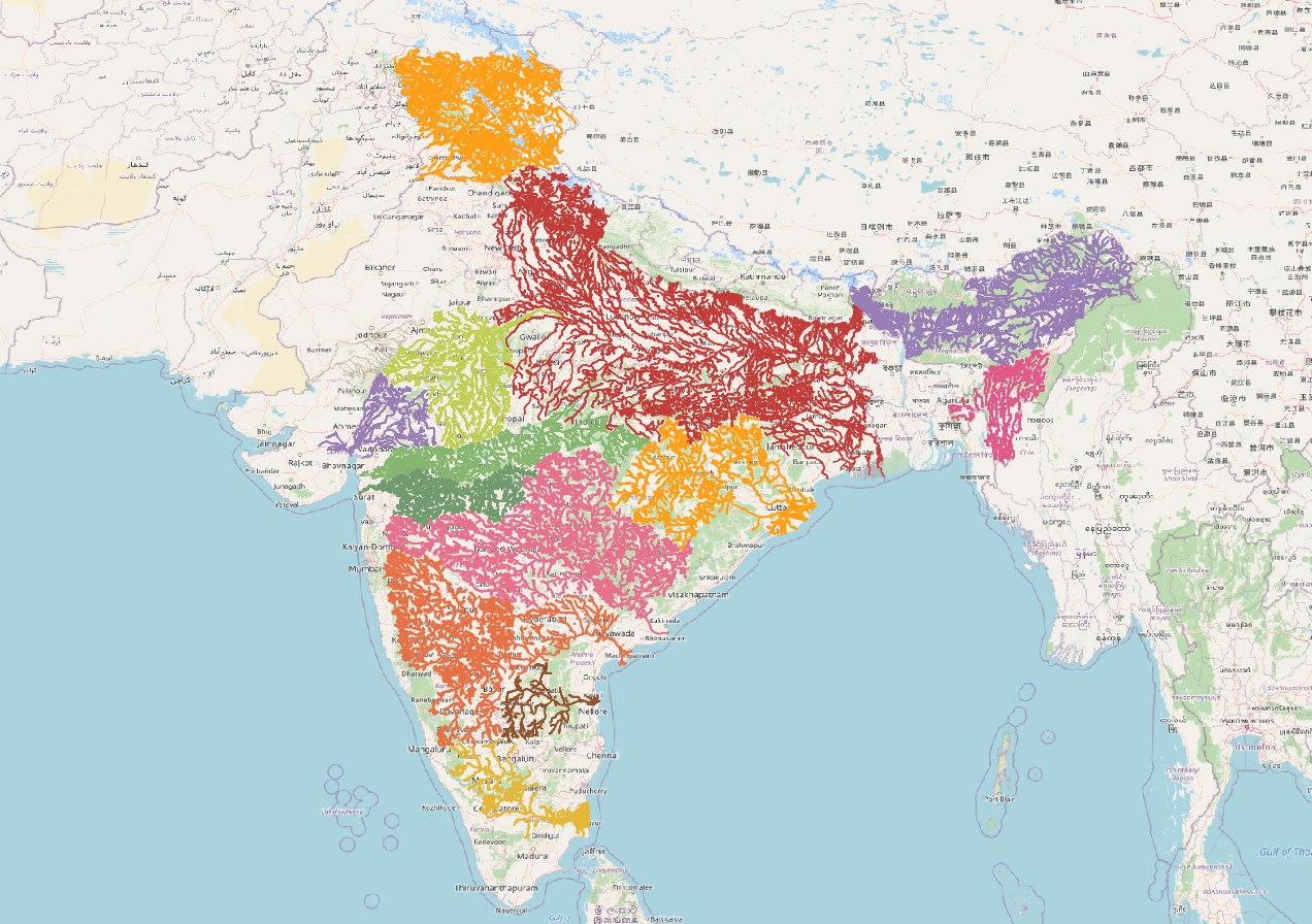
Map study
India river basins: distinguish watershed divides from state boundaries; compare east-flowing and west-flowing drainage.
- Read the source legend, scale and reference period before comparing regions.
- Connect spatial patterns to the processes discussed in this topic; this map is a study reference, not live operational data.
Credit: Heinz OSM · ODbL · sourceConverted to WebP on an opaque white background; proportionally resized without cropping. Original cartography and legend retained.
1. Geological setting and drainage characteristics
Peninsular drainage developed over an ancient landscape of crystalline rocks, plateaus, residual hills and sedimentary basins. Compared with the Himalayan rivers, many Peninsular rivers have relatively stable courses, broad valleys and comparatively subdued gradients across the plateau. However, geological age does not mean that every channel is equally old: uplift, faulting, erosion and river capture have modified the drainage network. Waterfalls and gorges occur where rivers cross resistant rocks or sharp changes in elevation.
The general eastward slope of much of the plateau explains why the Mahanadi, Godavari, Krishna, Cauvery and Pennar flow towards the Bay of Bengal. The Western Ghats stand close to the Arabian Sea, leaving a narrow western coastal plain. Consequently, most rivers originating on their western slopes have short courses, steep gradients and rapid runoff. Their eastern slopes feed much longer rivers extending across the plateau.
Rainfall provides the main source of discharge. Southwest monsoon rainfall produces the principal flood season in most basins, while northeast monsoon rainfall is especially important in southeastern India, including the lower Cauvery basin. Dry-season flows depend on groundwater, catchment conditions, reservoirs and withdrawals. Dendritic drainage is common over relatively uniform rocks; trellis drainage develops where alternating resistant and weaker rocks guide streams. Structural controls are especially evident in the Narmada and Tapi valleys.
- A drainage basin is the area drained by a river and its tributaries; a water divide separates adjoining basins.
- A left-bank or right-bank tributary is identified while facing downstream.
- Do not equate Peninsular origin with direct discharge into the sea: the Chambal, Betwa, Ken and Son join the Ganga river system.
2. Major east-flowing river systems
The Mahanadi rises in the Sihawa hills of Chhattisgarh and flows through Odisha before entering the Bay of Bengal. Its major tributaries include the Seonath, Hasdeo, Mand, Ib and Tel. The Hirakud Dam near Sambalpur is a major multipurpose project supporting flood moderation, irrigation and electricity generation. The lower basin forms a fertile delta, but monsoon floods remain a recurring hazard.
The Godavari rises near Trimbakeshwar in Maharashtra’s Nashik district and is often called the Dakshin Ganga. It flows across the Deccan towards the Andhra Pradesh coast. Important left-bank tributaries include the Purna, Pranhita, Indravati and Sabari; the Pravara and Manjira join from the right. The Pranhita system combines drainage from the Wardha, Wainganga and Penganga catchments. Extensive basin coverage across central and southern India makes tributary identification particularly important.
The Krishna rises near Mahabaleshwar in Maharashtra and flows through Karnataka, Telangana and Andhra Pradesh. The Bhima is a major left-bank tributary, while the Tungabhadra is a major right-bank tributary. The Tungabhadra forms from the union of the Tunga and Bhadra rivers in Karnataka. Other tributaries include the Koyna, Ghataprabha and Malaprabha. Major projects include Almatti, Srisailam and Nagarjuna Sagar.
The Cauvery rises at Talakaveri in the Brahmagiri hills of Karnataka and flows into Tamil Nadu before reaching the Bay of Bengal. Important tributaries include the Kabini, Hemavati, Shimsha, Bhavani and Amaravati. Its upper basin receives southwest monsoon rainfall, while the lower basin benefits from the northeast monsoon. The Pennar rises in Karnataka’s Nandi Hills and drains a comparatively dry region before reaching the Andhra Pradesh coast.
- Mahanadi: Chhattisgarh–Odisha axis; Hirakud project.
- Godavari: largest Peninsular basin; Indravati and Pranhita are tributaries.
- Krishna: Bhima and Tungabhadra; Nagarjuna Sagar project.
- Cauvery: Talakaveri source; Mettur Dam and a major delta in Tamil Nadu.
How catchment changes affect downstream rivers
- 1. Monsoon rainfall enters the catchment
- 2. Vegetation, soils and geology regulate infiltration and runoff
- 3. Tributaries convey water and sediment to the main river
- 4. Reservoirs and withdrawals modify flows and sediment transport
- 5. Changed downstream conditions affect farms, wetlands and river mouths
3. West-flowing rivers and northward-draining exceptions
The Narmada rises near Amarkantak in Madhya Pradesh and flows west between the Vindhya Range to the north and the Satpura Range to the south. Its structurally controlled valley is conventionally described as a rift valley. Near Jabalpur, it passes through the Marble Rocks gorge and forms the Dhuandhar Falls. The Tawa is an important tributary. The Sardar Sarovar project lies on the Narmada in Gujarat.
The Tapi, also called Tapti, rises near Multai in Madhya Pradesh’s Betul district. It flows west through Madhya Pradesh, Maharashtra and Gujarat, broadly south of the Satpura Range. The Purna is a major tributary, and Ukai is an important dam. Both the Tapi and Narmada enter the Gulf of Khambhat through estuarine mouths rather than forming extensive projecting deltas.
Short west-flowing rivers include the Mandovi and Zuari in Goa, the Kali, Sharavathi and Netravati in Karnataka, and the Periyar and Bharathapuzha in Kerala. Jog Falls occurs on the Sharavathi. The Sabarmati and Mahi also reach the Gulf of Khambhat, whereas the Luni drains towards the Rann of Kachchh. Not every west-flowing river occupies a rift valley. Conversely, several rivers arising on the plateau flow north or northeast: the Chambal, Betwa and Ken join the Yamuna, while the Son joins the Ganga.
- Amarkantak is associated with the sources of both the west-flowing Narmada and the eastward-draining Son.
- Distinguish the Purna tributary of the Godavari from the separate Purna tributary of the Tapi.
- The Damodar drains the Chota Nagpur Plateau and belongs to the Hugli drainage system.
| River | Source | Major tributaries | Outlet |
|---|---|---|---|
| Mahanadi | Sihawa hills, Chhattisgarh | Seonath, Hasdeo, Tel | Bay of Bengal; delta |
| Godavari | Trimbakeshwar, Maharashtra | Pranhita, Indravati, Manjira | Bay of Bengal; delta |
| Krishna | Near Mahabaleshwar, Maharashtra | Bhima, Tungabhadra, Koyna | Bay of Bengal; delta |
| Cauvery | Talakaveri, Karnataka | Kabini, Hemavati, Bhavani | Bay of Bengal; delta |
| Narmada | Amarkantak, Madhya Pradesh | Tawa, Hiran | Gulf of Khambhat; estuary |
| Tapi | Near Multai, Madhya Pradesh | Purna, Girna | Gulf of Khambhat; estuary |
4. Deltas, estuaries and river processes
A delta develops where river-borne sediment accumulates at the mouth faster than marine processes can remove it. The broad eastern coastal plains, sediment supply and suitable coastal conditions have supported major Peninsular deltas. Distributaries divide the lower river into multiple channels, supporting intensive agriculture, fisheries and wetlands. The Godavari–Krishna deltaic region and Cauvery delta are major agricultural landscapes.
An estuary is a coastal water body where river water mixes with seawater under tidal influence. The Narmada and Tapi mouths experience strong tidal action in the Gulf of Khambhat. Delta or estuary formation cannot be explained by flow direction alone: sediment load, basin geology, river discharge, waves, tides and coastal shape interact. Reservoir sediment trapping, sand extraction, subsidence and sea-level rise can increase erosion and salinity risks in lower river systems.
- Waterfalls reflect local relief and geological controls, not necessarily a young river system.
- Floodplains, wetlands and distributaries provide ecological functions as well as agricultural benefits.
5. Water use, governance and examination approach
Peninsular rivers sustain irrigation, hydropower, drinking-water supply, industries and inland fisheries. High seasonal variability creates pressure for reservoir storage, but dams also alter sediment movement, aquatic connectivity and downstream flows. Catchment degradation, urban sewage, industrial effluents and excessive sand mining further reduce river health. Basin management should integrate surface water, groundwater, environmental flows and floodplain protection.
Interstate disputes are prominent in the Cauvery, Krishna, Godavari and Mahanadi basins because rainfall, storage capacity and agricultural demand vary across states. Article 262 of the Constitution provides for parliamentary legislation on interstate river-water disputes; the Inter-State River Water Disputes Act, 1956 supplies the statutory framework for adjudication. For Prelims, distinguish a river’s main-channel states from the wider set of states lying within its drainage basin.
- Revise maps in the order: source, direction, tributaries, dams, mouth and neighbouring basins.
- Avoid absolute claims such as all Peninsular rivers flow east or all west-flowing rivers form estuaries.
Real-world case studies
Cauvery water sharing
Following the Supreme Court’s February 2018 judgment, the Union government notified the Cauvery Water Management Scheme in June 2018, establishing the Cauvery Water Management Authority and Cauvery Water Regulation Committee. The basin illustrates how monsoon variability and irrigation demand complicate interstate water sharing.
Godavari delta mangroves
Coringa Wildlife Sanctuary in Andhra Pradesh protects mangroves in the Godavari delta. These habitats support fisheries and coastal biodiversity and help buffer wave action. Their conservation requires attention to freshwater inflows, sediment supply and surrounding land-use pressures.
Previous year questions
No source-linked PYQ is available here yet. Use the practice questions below.
Practice questions
Practice MCQ 1
Which pair consists only of tributaries of the Godavari?
- A. Indravati and Pranhita
- B. Bhima and Kabini
- C. Tawa and Tel
- D. Tungabhadra and Manjira
Practice MCQ 2
Consider the statements: 1. The Narmada flows broadly between the Vindhya and Satpura ranges. 2. Both the Narmada and Tapi enter the Gulf of Khambhat. 3. Every west-flowing Peninsular river occupies a rift valley. Which are correct?
- A. 1 only
- B. 1 and 2 only
- C. 2 and 3 only
- D. 1, 2 and 3
Practice MCQ 3
Which waterfall–river pair is correctly matched?
- A. Jog Falls — Sharavathi
- B. Dhuandhar Falls — Tapi
- C. Shivanasamudra Falls — Godavari
- D. Chitrakote Falls — Krishna
Mains practice · Explain how relief, geological structure and monsoon rainfall shape Peninsular drainage. Discuss their implications for water management. Answer in 250 words.
- Relate the plateau’s general eastward slope and the Western Ghats watershed to river direction.
- Explain structural control using the Narmada and Tapi valleys.
- Discuss seasonal discharge and the northeast monsoon contribution to southeastern basins.
- Distinguish deltaic and estuarine mouths using sediment and coastal processes.
- Connect irrigation and storage needs with interstate cooperation, environmental flows and catchment conservation.
Further reading
- NCERT, India: Physical Environment, Class XI, chapter on Drainage System.
- NCERT, Contemporary India–I, Class IX, chapter on Drainage.
- Central Water Commission and ISRO, River Basin Atlas of India.
- India-WRIS portal: river basins, reservoirs and water-resources maps.
- India Code: Inter-State River Water Disputes Act, 1956.
Preparing for UPSC Civil Services? Get classroom teaching, answer-writing evaluation and mentorship at Pragnya IAS Academy, Ashok Nagar — see why aspirants choose us for IAS coaching in Hyderabad.