
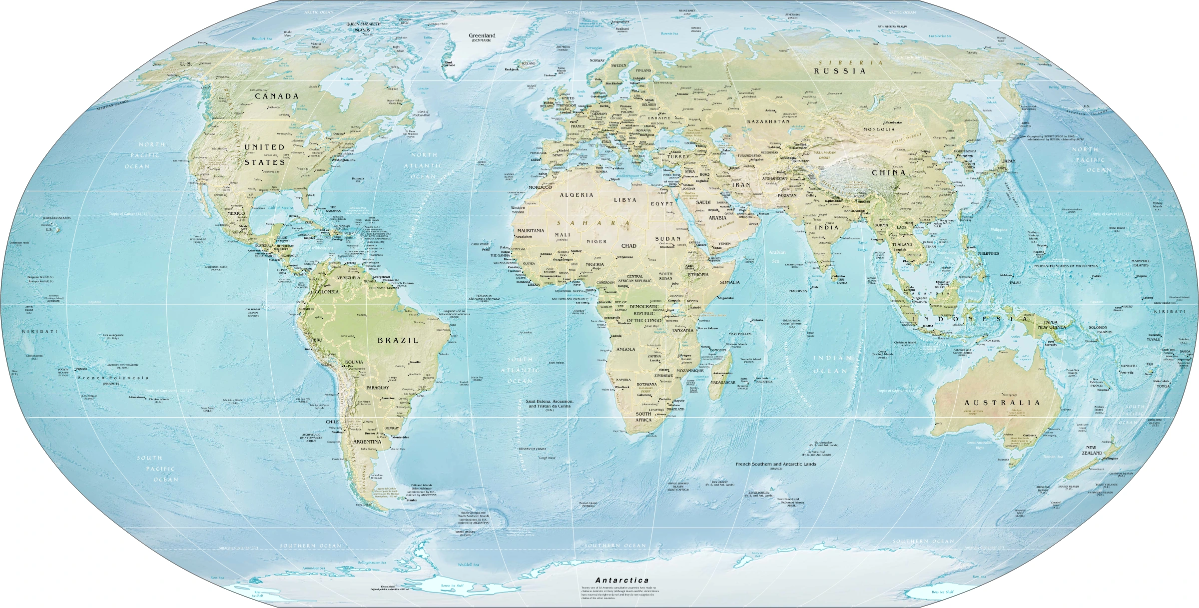
Map study
World physical relief: locate major mountain belts, plains and ocean basins. Regional orientation, not a detailed local landform survey.
- Read the source date and legend; distinguish territory, influence and geographic location.
- Historical boundaries and reference memberships are not live political or operational data.
Credit: US Government; Central Intelligence Agency · Public domain · sourceConverted to WebP on an opaque white background; proportionally resized without cropping. Original cartography and legend retained.
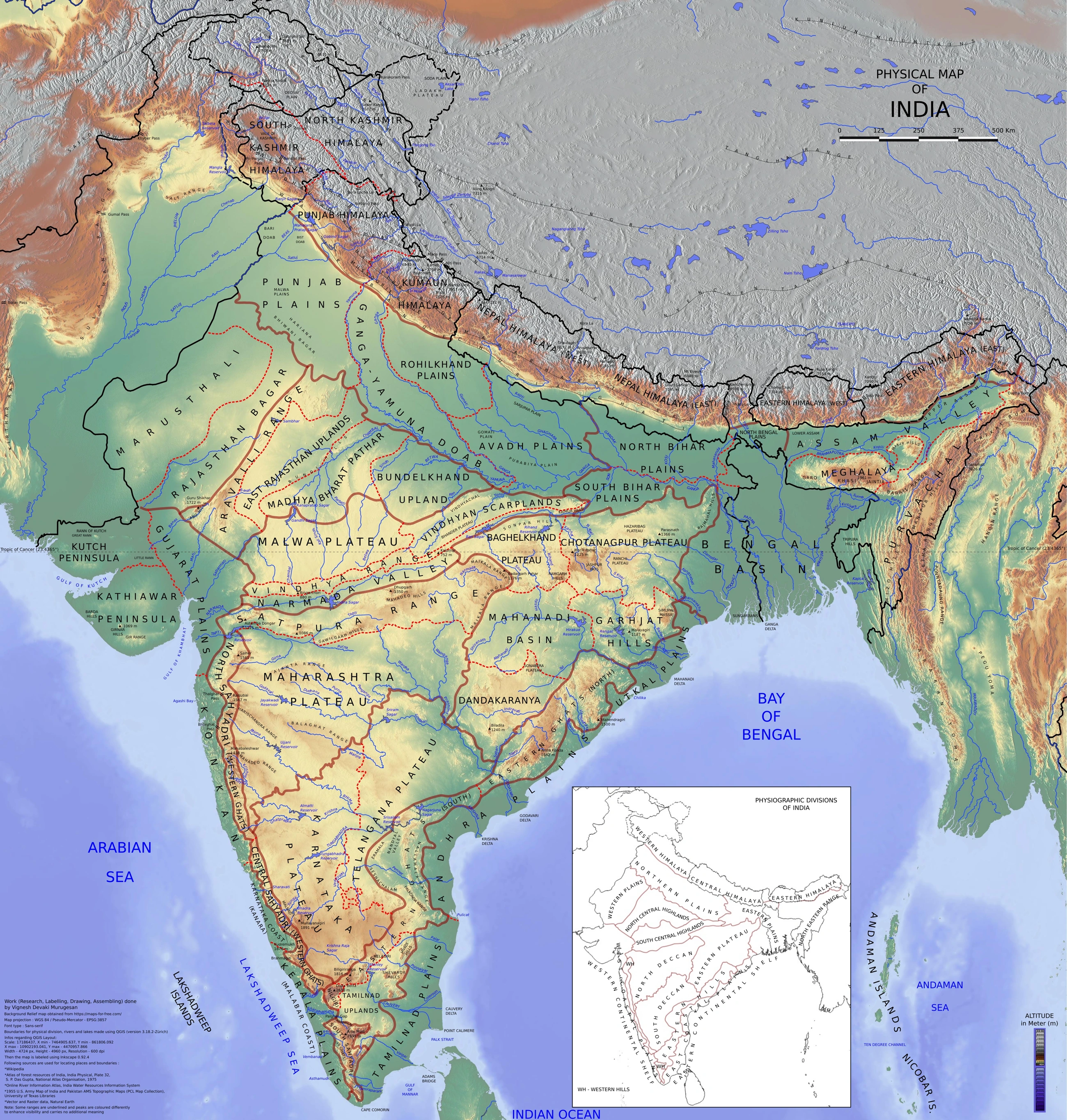
Map study
Physical divisions of India: locate mountains, plains, plateau, desert, coast and islands. Use regional relief to interpret landform processes; this is not a local geomorphological survey.
- Read the legend and reference date before interpreting regional patterns.
- Relate the map to the article’s topic; verify current administrative boundaries or data separately.
Credit: Vigneshdm1990 · CC BY-SA 4.0 · sourceConverted to WebP on an opaque white background; proportionally resized without cropping. Original cartography and legend retained.
1. Framework for understanding India’s relief
Physiography describes the physical form of Earth’s surface, especially relief and landforms. India’s six broad divisions are a useful school-level classification, but each contains substantial internal variation. Geological structure, elevation, slope, drainage and the processes shaping the surface should be studied together. A plateau, for example, need not be uniformly flat or higher than every neighbouring mountain.
Three broad geological components underlie this diversity. The Peninsular block consists largely of ancient crystalline rocks, although younger sedimentary formations and volcanic rocks cover extensive areas. The Himalayas developed through convergence and collision of the Indian and Eurasian plates, beginning roughly 50 million years ago. Between them, the Indo-Gangetic-Brahmaputra plains occupy a sediment-filled foreland basin associated with Himalayan uplift.
Endogenic processes, including folding, faulting and volcanism, create major relief features. Exogenic processes, including weathering, river erosion, wind action and marine deposition, modify them. Consequently, physiography is dynamic: Himalayan slopes remain tectonically active, rivers shift across floodplains, and coastlines respond to sediment supply, waves and relative sea-level change.
- For map questions, connect each division with bordering rivers, mountain ranges, passes and neighbouring regions.
- Distinguish geological age from present elevation: an old rock mass can be uplifted, while a young depositional plain can remain low-lying.
2. Himalayan Mountains and northeastern hills
The Himalayas form an approximately 2,400-kilometre-long arc along India’s northern margin. Their main longitudinal divisions are the Greater Himalaya or Himadri, Lesser Himalaya or Himachal, and Shiwalik ranges. The Himadri contains the highest peaks and major glaciers. The Lesser Himalaya includes ranges such as the Pir Panjal and Dhauladhar, while the Shiwaliks comprise relatively unconsolidated sediments brought down from higher ranges.
Longitudinal valleys between the Lesser Himalaya and Shiwaliks are called duns; Dehra Dun is a prominent example. Beyond the main Himalayan ranges lie the Trans-Himalayan ranges, including the Karakoram, Ladakh and Zanskar. These should not be confused with the three parallel belts of the main Himalaya.
River valleys provide another regional classification: Punjab Himalaya between the Indus and Satluj, Kumaon Himalaya between the Satluj and Kali, Nepal Himalaya between the Kali and Tista, and Assam Himalaya between the Tista and Dihang. These are conventional physiographic labels rather than present-day administrative units. Beyond the Dihang gorge, the mountain system bends southward into the Purvachal, including the Patkai, Naga and Mizo hills.
- The Himalayas influence monsoon circulation, support perennial rivers and contain diverse altitudinal ecosystems.
- Active tectonics, steep slopes, intense rainfall and poorly planned slope modification contribute to earthquakes, landslides and flash floods.
Formation and modification of the Northern Plains
- 1. Indian–Eurasian plate convergence raises the Himalayan mountain system.
- 2. Loading and flexure of the Indian plate help create a foreland basin.
- 3. Weathering, glaciers and rivers generate and transport sediment.
- 4. Rivers deposit alluvium as gradients decline towards the plains.
- 5. Channel migration and repeated floods form terraces, floodplains, levees and oxbow lakes.
3. Northern Plains: deposition and regional variation
The Northern Plains were built by the Indus, Ganga and Brahmaputra systems and their tributaries through prolonged alluvial deposition. Their broad subdivisions are the Punjab Plains, Ganga Plains and Brahmaputra Plains. Low gradients, fertile soils and accessible groundwater support intensive agriculture and dense settlement, although flood exposure, waterlogging and groundwater depletion vary considerably across the region.
From the Himalayan foothills southward, the Bhabar is a narrow belt of coarse pebbles and gravels deposited by descending streams. Its high permeability allows many smaller streams to disappear underground. South of it, groundwater and streams re-emerge in the moist Terai belt, historically characterised by marshes and dense vegetation. Large areas of the Terai have subsequently been reclaimed for agriculture.
Bhangar and Khadar represent older and newer alluvium respectively. Bhangar occupies relatively elevated terraces and may contain calcareous concretions called kankar. Khadar lies in active floodplains and is renewed by recurring deposition. This distinction is based on depositional setting and relative age, not simply location north or south of a river.
- Meanders, oxbow lakes, natural levees and flood basins are characteristic alluvial landforms.
- The Brahmaputra commonly develops braided channels; channel migration and bank erosion create major challenges for settlements and transport.
| Division | Dominant character | Representative feature | Key examination link |
|---|---|---|---|
| Himalayan Mountains | Young, tectonically active mountain system | Himadri, Lesser Himalaya, Shiwaliks | Glaciers, passes, earthquakes and landslides |
| Northern Plains | River-deposited alluvial lowlands | Bhabar, Terai, Bhangar and Khadar | Agriculture, floods and groundwater |
| Peninsular Plateau | Ancient continental upland | Deccan Traps and Chota Nagpur | Minerals, soils and drainage |
| Indian Desert | Arid region with aeolian and fluvial landforms | Dunes and saline depressions | Internal drainage and desertification |
| Coastal Plains | Marine and river-influenced lowlands | Estuaries, deltas and lagoons | Ports, cyclones and coastal erosion |
| Islands | Contrasting coral and tectonic settings | Lakshadweep and Andaman–Nicobar | Reefs, volcanism and strategic location |
4. Peninsular Plateau and its margins
The Peninsular Plateau is a broadly triangular upland composed mainly of old crystalline igneous and metamorphic rocks, with extensive sedimentary and volcanic covers. Its broad divisions are the Central Highlands north of the Narmada and the Deccan Plateau to the south. The Malwa Plateau, Bundelkhand, Baghelkhand and Chota Nagpur region illustrate its internal diversity.
The Deccan generally slopes eastward, helping explain why the Godavari, Krishna and Kaveri drain towards the Bay of Bengal. The Narmada and Tapi are important exceptions, flowing westward through structurally controlled troughs. Much of northwestern Deccan is covered by basaltic lava flows of the Deccan Traps, emplaced mainly around 66 million years ago. Weathering of basalt contributes to black-soil development.
The Western Ghats form a relatively continuous elevated western margin, whereas the Eastern Ghats are lower, more discontinuous and dissected by major rivers. They converge in the Nilgiri region. The Meghalaya Plateau, including the Garo, Khasi and Jaintia hills, is a northeastern extension of the Peninsular block, separated from the main plateau by sediment-covered structural depressions.
- Anamudi, in Kerala, is the highest peak of Peninsular India.
- The Palghat Gap separates the Nilgiri Hills from the hill ranges immediately to their south.
- Chota Nagpur is especially important for mineral resources; plateau rivers also support hydropower and irrigation.
5. Indian Desert and arid landforms
The Indian Desert, or Thar, lies mainly west of the Aravalli range in Rajasthan and extends into Pakistan. Low and highly variable rainfall, high evaporation and sparse vegetation favour wind erosion and deposition. Sand dunes are prominent, but the region also contains rocky surfaces, gravel plains and saline depressions; it is not an uninterrupted expanse of sand.
Barchans are crescent-shaped dunes associated with a dominant wind direction and limited sand supply. Their horns point downwind. Drainage is often seasonal or internal. The Luni is the principal river of the southern desert region and flows towards the Rann of Kachchh. Sambhar is an important inland saline lake in Rajasthan.
The Aravallis run broadly southwest–northeast, approximately parallel to the Arabian Sea branch of the southwest monsoon, limiting continuous orographic uplift along much of their length. However, aridity cannot be attributed to orientation alone: monsoon circulation, moisture availability and continental conditions also matter. Irrigation has transformed parts of the desert, but poor drainage can produce waterlogging and salinity.
- Aridity is a climatic condition; desertification is land degradation in drylands.
- Canal irrigation changes land use, but does not eliminate the region’s underlying ecological constraints.
6. Coastal Plains and Islands
The Western Coastal Plain lies between the Western Ghats and Arabian Sea. It is generally narrow and includes the Konkan, Kannad or Karnataka coast, and Malabar coast. Short, steep rivers commonly form estuaries rather than extensive deltas. Kerala’s backwaters, including Vembanad, illustrate coastal lagoons and interconnected waterways.
The Eastern Coastal Plain, between the Eastern Ghats and Bay of Bengal, is generally wider. It includes the Northern Circars and Coromandel coast. The Mahanadi, Godavari, Krishna and Kaveri have built major deltas. Chilika in Odisha and Pulicat on the Andhra Pradesh–Tamil Nadu boundary are important coastal lagoons. Cyclones, storm surges, erosion and saltwater intrusion are major coastal hazards.
Lakshadweep comprises coral islands and atolls in the Arabian Sea, supported by reefs developed over submarine foundations. The Andaman and Nicobar Islands lie in the Bay of Bengal in an active tectonic setting. The Ten Degree Channel separates the Andaman and Nicobar groups. Barren Island contains India’s only confirmed active volcano. The islands’ ecological sensitivity, seismic exposure and strategic location make them important beyond their small land area.
- Not all islands share the same origin: distinguish coral atolls from tectonic and volcanic island settings.
- Delta formation depends on sediment supply, river discharge, coastal configuration, waves and tides—not simply the direction in which a river flows.
Real-world case studies
Kosi: a mobile river on an alluvial plain
In August 2008, the Kosi breached its eastern afflux embankment near Kusaha in Nepal and diverted into an older course, causing devastating flooding in Bihar. High sediment loads, channel instability and embankment vulnerability demonstrated that low-relief plains are not static landscapes. Flood planning must account for historical channels and basin-wide sediment dynamics.
Indira Gandhi Canal: transforming desert land use
The Indira Gandhi Canal conveys water from the Harike system to northwestern Rajasthan, expanding irrigation and settlement in arid areas. Its command region also illustrates risks of waterlogging and secondary salinisation where seepage, excessive irrigation and inadequate drainage interact. Physiographic constraints therefore remain relevant even after major engineering interventions.
Previous year questions
No source-linked PYQ is available here yet. Use the practice questions below.
Practice questions
Practice MCQ 1
Consider the following statements about the Northern Plains: 1. The Bhabar contains coarse deposits through which smaller streams may disappear. 2. The Terai lies immediately north of the Bhabar. 3. Khadar represents relatively recent floodplain alluvium. Which statements are correct?
- A. 1 and 2 only
- B. 1 and 3 only
- C. 2 and 3 only
- D. 1, 2 and 3
Practice MCQ 2
Which one of the following pairs is incorrectly matched?
- A. Ten Degree Channel — Separation of the Andaman and Nicobar groups
- B. Palghat Gap — Gap south of the Nilgiri Hills
- C. Lakshadweep — Coral islands and atolls
- D. Eastern Ghats — Continuous mountain barrier unbroken by major rivers
Practice MCQ 3
Consider the following statements: 1. The Meghalaya Plateau is a northeastern extension of the Peninsular block. 2. The Narmada and Tapi flow westward through structurally controlled troughs. 3. The Western Coastal Plain is generally wider than the Eastern Coastal Plain. Which statements are correct?
- A. 1 only
- B. 2 and 3 only
- C. 1 and 2 only
- D. 1, 2 and 3
Mains practice · Explain how geological structure and geomorphic processes have shaped India’s major physiographic divisions. Illustrate their influence on drainage and natural hazards. Answer in 250 words.
- Introduce the contrast between the ancient Peninsular block, young Himalayas and depositional Northern Plains.
- Explain collision, folding and foreland-basin sedimentation.
- Discuss plateau structure, Deccan volcanism and westward-flowing structurally controlled rivers.
- Connect desert landforms with wind action and coastal plains with river–marine interaction.
- Differentiate coral islands from the tectonically active Andaman–Nicobar setting.
- Link relief with Himalayan landslides, floodplain channel migration and coastal storm-surge exposure.
- Use a small labelled outline map and conclude with the need for region-specific land-use planning.
Further reading
- NCERT, Contemporary India–I, Class IX: Physical Features of India.
- NCERT, India: Physical Environment, Class XI: Structure and Physiography; Drainage System.
- NCERT, Fundamentals of Physical Geography, Class XI: Geomorphic Processes; Landforms and their Evolution.
- Geological Survey of India: geological maps and publications, gsi.gov.in.
- National Disaster Management Authority: guidelines on earthquakes, landslides and floods, ndma.gov.in.
Preparing for UPSC Civil Services? Get classroom teaching, answer-writing evaluation and mentorship at Pragnya IAS Academy, Ashok Nagar — see why aspirants choose us for IAS coaching in Hyderabad.