

extinction of dinosaurs in Deccan Traps in Western Ghats, India. See also en:Talk:Deccan Traps#Image: artist's rendition of dinosaur extinction.
Credit: National Science Foundation, Zina Deretsky · Public domain · source

Plateau Point is 1.5 miles ( 2.4 km ) beyond Indian Garden. This is a strenuous day hike that takes from 8-12 hours round trip (on Bright Angel Trail) from Grand Canyon Village. The total round trip d
Credit: Grand Canyon NPS · CC BY 2.0 · source
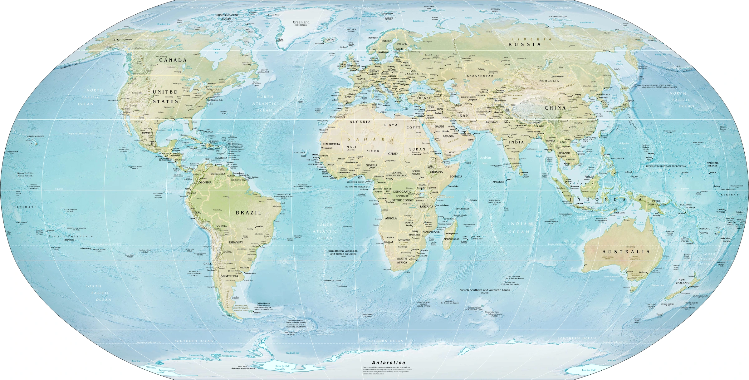
Map study
World physical relief: locate major mountain belts, plains and ocean basins. Regional orientation, not a detailed local landform survey.
- Read the source date and legend; distinguish territory, influence and geographic location.
- Historical boundaries and reference memberships are not live political or operational data.
Credit: US Government; Central Intelligence Agency · Public domain · sourceConverted to WebP on an opaque white background; proportionally resized without cropping. Original cartography and legend retained.
1. Meaning and diagnostic features
A plateau is a broad upland whose surface is relatively flat, gently undulating or locally dissected. It usually stands distinctly above adjoining terrain and may terminate in an escarpment, a long, steep slope separating surfaces at different elevations. The expression tableland captures its general appearance, but should not be interpreted as requiring a perfectly horizontal surface. Many mature plateaus contain deep valleys, isolated hills and several erosion levels.
Plateaus differ from plains primarily in their relative elevation and regional relief, and from mountain ranges in the greater extent of their summit surfaces. These categories grade into one another: uplifted plateau margins may resemble mountains, while heavily dissected plateaus may lose much of their original flat surface. The Colorado Plateau, for example, remains a plateau at the regional scale despite spectacular canyons.
Absolute elevation alone is therefore an unreliable test. The Tibetan Plateau is exceptionally high, whereas many Indian plateau surfaces stand only a few hundred metres above sea level. Geomorphologists examine surface continuity, slope breaks, rock structure and geological history together. A mesa is a smaller, flat-topped erosional remnant bounded by steep sides; a butte is generally smaller and narrower still.
- Regional form: elevated, extensive surface with comparatively low relief between major valleys.
- Local form: escarpments, gorges, waterfalls, mesas and residual hills may occur.
- Classification caution: categories based on origin and location can overlap.
2. Formation and classification
Tectonic plateaus form when large crustal areas rise through deformation, faulting or broad regional uplift. Crustal shortening and thickening during continental collision can produce high plateaus. The Tibetan Plateau developed through the India–Eurasia collision and subsequent deformation. It is an intermontane plateau associated with the Himalaya, Karakoram, Kunlun and other mountain systems. Its evolution involved multiple phases rather than a single uplift event.
Volcanic plateaus develop through successive lava outpourings, especially fluid basalt released along fissures. Individual flows spread over wide areas and build thick, broadly layered sequences. The Deccan Traps of India and Columbia River Basalt province of the northwestern United States are standard examples. Weathering and erosion of layered lava can produce step-like slopes; the term trap derives from a word meaning stairs. Such plateaus need not resemble volcanic cones.
Erosional or residual plateaus develop where resistant rocks or resistant surface layers survive denudation better than adjoining terrain. Differential erosion removes weaker material while preserving elevated remnants. Uplift and erosion commonly act together, so attributing every plateau to one process can be misleading. A dissected plateau describes the degree of valley incision, not necessarily an independent origin.
A second classification uses position. Intermontane plateaus occur among mountain systems, as in Tibet and the Andean Altiplano. Piedmont plateaus occupy foothill zones between mountains and adjacent lowlands; the eastern United States Piedmont is a familiar example. Continental plateaus occupy broad continental interiors or large upland regions, illustrated by extensive parts of Africa. These geographical labels do not, by themselves, establish the rocks or processes responsible.
- Origin-based labels: tectonic, volcanic and erosional.
- Position-based labels: intermontane, piedmont and continental.
- Surface condition: undissected, dissected or deeply incised.
One possible pathway of plateau dissection
- 1. Regional uplift creates an elevated surface
- 2. Rivers incise where gradient and stream power permit
- 3. Tributaries extend and subdivide interfluves
- 4. Weathering and slope retreat widen valleys
- 5. Resistant remnants may survive as mesas and buttes
3. Evolution, drainage and associated landforms
After uplift or lava accumulation, running water, weathering and mass movement progressively modify a plateau. Greater height above a river's base level can increase the potential for incision. Rivers cut valleys into the upland, while tributaries extend headward and divide the surface into interfluves. Renewed uplift or a fall in base level may rejuvenate a river, although discharge, sediment load and rock resistance also control erosion.
Waterfalls and rapids commonly develop at plateau margins, resistant rock bands or abrupt changes in valley gradient. Knickpoints may migrate upstream through erosion. In relatively dry landscapes with resistant horizontal strata, differential erosion can create steep-sided mesas and buttes. These features are associated with plateau dissection but are not restricted to plateaus.
Drainage patterns reflect structure rather than the plateau label alone. Dendritic drainage is common over relatively uniform rocks; trellis drainage may follow alternating resistant and weak belts; radial drainage develops around a central high. Some plateau basins are endorheic, meaning their water does not reach the ocean. Lakes and salt flats of the Tibetan and Andean highlands illustrate how relief and aridity can combine to produce internal drainage.
- Incision cuts downward; lateral erosion widens valleys; weathering and slope processes modify valley sides.
- A canyon is not proof of recent uplift alone: geological structure, climate and drainage history must also be considered.
| Plateau or province | Location | Key association |
|---|---|---|
| Tibetan Plateau | Central Asia, mainly China | Collision-related crustal thickening; intermontane high plateau |
| Deccan Traps | Western and central India | Continental flood basalts; extensive stepped terrain |
| Colorado Plateau | Southwestern United States | Uplifted sedimentary rocks and deep canyon incision |
| Altiplano | Mainly Bolivia and Peru | Intermontane Andean plateau with internally drained basins |
| Chota Nagpur Plateau | Eastern India | Ancient crystalline terrain, mineral belts and sedimentary coal basins |
4. Indian plateaus and map-based geography
The Peninsular Plateau is an ancient continental block composed extensively of crystalline igneous and metamorphic rocks, with sedimentary basins and large basalt-covered areas. NCERT broadly divides it into the Central Highlands and the Deccan Plateau. The Central Highlands lie mainly north of the Narmada, while the triangular Deccan Plateau lies to its south. The Narmada occupies a structurally controlled rift valley between the Vindhyan region and Satpura ranges.
The Deccan Plateau generally slopes eastward, helping explain why the Godavari, Krishna and Kaveri drain towards the Bay of Bengal. The Western Ghats form a prominent western escarpment, while the Eastern Ghats are more discontinuous and are crossed by major rivers. West-flowing rivers such as the Narmada and Tapi show why regional slope cannot explain every river: geological structure also matters.
The Malwa Plateau includes extensive basaltic terrain, whereas Bundelkhand is strongly associated with ancient crystalline rocks. The Chota Nagpur Plateau spans much of Jharkhand and neighbouring areas and contains important mineral belts. Meghalaya's Shillong Plateau is a northeastern extension of the Peninsular block, separated from the main plateau by intervening lowlands. Crucially, the geographical Deccan Plateau is not identical to the Deccan Traps: the former includes substantial non-basaltic terrain.
- Map anchors: Malwa, Bundelkhand, Baghelkhand, Chota Nagpur, Telangana, Karnataka and Meghalaya uplands.
- Waterfall example: Hundru Falls occurs on the Subarnarekha in the Chota Nagpur region.
- Soil link: basalt favours black-soil development in suitable conditions, but red and lateritic soils also occur across Peninsular uplands.
5. Economic significance and environmental constraints
Plateaus support mining, agriculture, grazing, forestry and hydropower, but their resources depend on geological history and climate. Ancient shield regions may contain metallic ores, while coal occurs in suitable sedimentary basins rather than in crystalline rocks simply because they form a plateau. The Damodar Valley's Gondwana coalfields and the iron-ore belts of eastern India illustrate this distinction. Bauxite may develop through intense weathering and lateritisation on suitable upland surfaces.
Plateau agriculture varies widely. Moisture-retaining black soils support cotton and other crops in parts of the Deccan, while drier uplands favour millets, pulses and livestock. Groundwater in hard-rock terrain is concentrated mainly in weathered zones, joints and fractures, creating locally variable well yields. High plateaus face additional limitations from cold, short growing seasons and sparse vegetation.
Mining, deforestation and poorly managed cultivation can accelerate erosion and damage headwater catchments. Sustainable management requires contour-based soil conservation, vegetation recovery, protection of drainage lines, geological assessment of groundwater and mine-site rehabilitation. Watershed planning should include the needs and rights of local communities rather than treating plateau regions only as sources of minerals, water or energy.
Real-world case studies
Colorado Plateau and the Grand Canyon
The Colorado River and its tributaries cut deeply into the elevated Colorado Plateau, exposing thick rock sequences. Grand Canyon National Park illustrates the combined influence of regional uplift, river integration, differential erosion and long geological history. Its rugged landscape demonstrates that a plateau need not remain locally flat.
Chota Nagpur: resources and competing land uses
The Chota Nagpur region contains crystalline uplands alongside coal-bearing Gondwana basins, including the Jharia and Bokaro coalfields. Mining and industry provide livelihoods but also create land degradation, pollution and displacement pressures. Jharia's coal fires highlight the need for scientific mine management and rehabilitation.
Previous year questions
No source-linked PYQ is available here yet. Use the practice questions below.
Practice questions
Practice MCQ 1
Consider the following statements: 1. All plateaus originate through lava accumulation. 2. A plateau may contain deeply incised valleys. 3. Intermontane is a classification based primarily on geographical position. Which statements are correct?
- A. 1 and 2 only
- B. 2 and 3 only
- C. 1 and 3 only
- D. 1, 2 and 3
Practice MCQ 2
Which pair is incorrectly matched?
- A. Tibetan Plateau: India–Eurasia collision
- B. Deccan Traps: Extensive basaltic lava flows
- C. Colorado Plateau: Canyon incision
- D. Altiplano: East African plateau
Practice MCQ 3
With reference to the Indian Peninsular Plateau, consider the following statements: 1. The Deccan Plateau and Deccan Traps have identical geographical extent. 2. Geological structure helps explain the westward courses of the Narmada and Tapi. 3. Hard-rock groundwater commonly occurs in weathered and fractured zones. Which statements are correct?
- A. 1 only
- B. 1 and 2 only
- C. 2 and 3 only
- D. 1, 2 and 3
Mains practice · Explain the major processes responsible for plateau formation. Using Indian examples, examine how geology and relief influence their economic potential and environmental vulnerabilities. Answer in 250 words.
- Define a plateau using relative elevation, surface extent and relief.
- Explain tectonic uplift, fissure volcanism and differential erosion.
- Distinguish the Deccan Plateau from the Deccan Traps.
- Connect Chota Nagpur's geological diversity with ores and coal-bearing basins.
- Discuss soils, drainage, hydropower and fractured-rock groundwater.
- Conclude with watershed conservation, responsible mining and community-sensitive planning.
Further reading
- NCERT, Class VI, Social Science: The Earth Our Habitat, Major Landforms of the Earth.
- NCERT, Class XI, India: Physical Environment, Structure and Physiography.
- NCERT, Class XI, Fundamentals of Physical Geography, Landforms and their Evolution.
- Geological Survey of India: publications on Indian geology and the Deccan volcanic province, gsi.gov.in.
- National Park Service: Grand Canyon geology resources, nps.gov/grca.
Preparing for UPSC Civil Services? Get classroom teaching, answer-writing evaluation and mentorship at Pragnya IAS Academy, Ashok Nagar — see why aspirants choose us for IAS coaching in Hyderabad.