

Himalaya from the International Space Station. In addition to looking heavenward, NASA helps the world see the Earth in ways no one else can. Astronauts on board the International Space Station recent
Credit: NASA · Public domain · source

The Sierra Nevada is a mountain range in the western United States, between the Central Valley of California and the Basin and Range Province. The vast majority of the range lies in the state of Calif
Credit: Ken Lund from Reno, Nevada, USA · CC BY-SA 2.0 · source
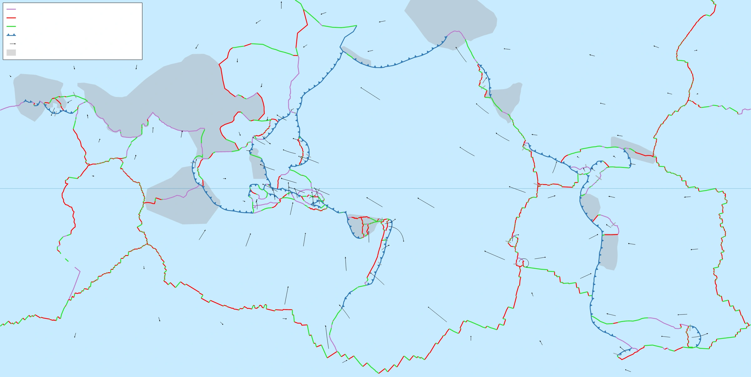
Map study
World tectonic plates: locate the Indian and Eurasian plates and distinguish convergent, divergent and transform boundaries through the legend.
- Read the source legend, scale and reference period before comparing regions.
- Connect spatial patterns to the processes discussed in this topic; this map is a study reference, not live operational data.
Credit: Eric Gaba (Sting) · CC BY-SA 2.5 · sourceConverted to WebP on an opaque white background; proportionally resized without cropping. Original cartography and legend retained.
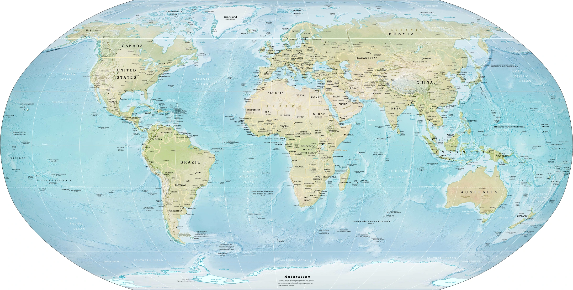
Map study
World physical relief: locate major mountain belts, plains and ocean basins. Regional orientation, not a detailed local landform survey.
- Read the source date and legend; distinguish territory, influence and geographic location.
- Historical boundaries and reference memberships are not live political or operational data.
Credit: US Government; Central Intelligence Agency · Public domain · sourceConverted to WebP on an opaque white background; proportionally resized without cropping. Original cartography and legend retained.
1. Mountain relief and the foundations of mountain building
A mountain is an elevated, usually steep and rugged part of the Earth's surface with appreciable relief relative to its surroundings. A range is an elongated group of related mountains, while a mountain system comprises several associated ranges. A cordillera is an extensive assemblage of ranges, plateaus and intermontane basins, exemplified by the western Americas. A massif is a relatively compact mountain mass. Altitude measures elevation above sea level, whereas local relief measures the difference between nearby high and low points.
Mountain building reflects interactions between internal and external processes. Plate convergence compresses and thickens the crust; faulting displaces crustal blocks; and volcanic eruptions accumulate lava and fragmental material. These mechanisms may operate together. The Himalayas, for example, contain folds, major thrust faults and uplifted crustal slices rather than being simple folds in layered rocks. Their development illustrates how mountain belts evolve through deformation over millions of years.
Isostasy helps explain why thick continental crust can support high elevations. In a simplified model, mountain belts possess deep, relatively low-density crustal roots, comparable to the submerged part of a floating iceberg. Removal of material by erosion can induce isostatic rebound. Nevertheless, elevation is not controlled by crustal thickness alone: lithospheric strength, mantle processes and erosion also contribute. Uplift is therefore not identical to an increase in surface elevation, because simultaneous denudation may remove much of the rising rock.
2. Genetic classification and diagnostic landforms
Fold mountains arise predominantly where compression bends and shortens rock layers, usually alongside thrust faulting. Anticlines are arch-like folds and synclines are trough-like folds in a simple, upright sequence. They should not automatically be equated with ridges and valleys: differential erosion can remove softer anticlinal rocks and leave resistant synclinal strata as elevated relief. This produces relief inversion, an important reminder that rock structure and present topography need not coincide.
Fault-block mountains develop through displacement along faults. Under extension, normal faults may produce raised blocks called horsts and down-dropped blocks called grabens. Some mountains are tilted blocks rather than symmetrical horsts. The Vosges and Black Forest flank the Upper Rhine Graben; the Sierra Nevada is a prominent tilted fault-block range. The Satpura region is commonly cited in Indian school geography as block-mountain terrain, although its geological history includes multiple tectonic and volcanic episodes.
Volcanic mountains are constructed by erupted material. Shield volcanoes have broad profiles associated mainly with fluid basaltic lava, as at Mauna Loa. Stratovolcanoes commonly form steeper cones built from alternating lava and pyroclastic deposits, as at Mount Fuji. Residual or erosional mountains are resistant remnants left after prolonged denudation. Domal mountains may result from broad crustal upwarping or intrusive activity. These categories describe dominant origins, not mutually exclusive histories.
Simplified evolution of a continental collision mountain belt
- 1. Continents converge across an intervening ocean
- 2. Oceanic lithosphere is progressively consumed by subduction
- 3. Continental collision produces shortening, folding and thrusting
- 4. Crustal thickening and uplift build mountain relief
- 5. Rivers, glaciers and mass movements remove and redistribute material
- 6. Continued tectonics and isostatic adjustment interact with denudation
3. Plate tectonics and the global mountain belts
At oceanic–continental convergent margins, the denser oceanic plate subducts beneath continental lithosphere. Compression, crustal deformation and magma generation can build a continental mountain belt with a volcanic arc. The Andes developed along the western margin of South America, principally through subduction of the Nazca Plate beneath the South American Plate. Volcanism is not continuous along every segment because variations in subduction geometry influence magma generation and ascent.
Continental collision follows the consumption of intervening oceanic lithosphere. Because continental crust is relatively buoyant, collision generally produces major crustal shortening and thickening rather than straightforward subduction of an entire continent. The Himalaya–Tibetan system formed through convergence of India and Eurasia after closure of the intervening Tethyan oceanic domain. Collision began roughly 50–60 million years ago, although estimates depend on the evidence and definition used. Unlike the Andes, the Himalayan mountain front is not a subduction-related active volcanic arc.
The Alpine–Himalayan belt extends through southern Europe and Asia, including the Alps, Zagros and Himalayas. The circum-Pacific region includes the Andes and several complex North American and island-arc mountain systems. Introductory geography contrasts geologically young belts with older, deeply eroded systems such as the Appalachians and Urals. However, older mountains may be rejuvenated by later uplift. The label 'young fold mountain' indicates a broad geological history, not that every rock exposed there formed recently.
| Dominant type | Principal mechanism | Examples | Exam distinction |
|---|---|---|---|
| Collision mountain belt | Continental convergence and crustal thickening | Himalayas, Alps | Folding occurs together with major thrusting |
| Subduction mountain belt | Oceanic plate subduction beneath a continent | Andes | Commonly includes a continental volcanic arc |
| Fault-block mountain | Differential displacement along faults | Sierra Nevada; Vosges–Black Forest | Includes tilted blocks and horsts |
| Volcanic mountain | Accumulation of erupted material | Mauna Loa, Mount Fuji | May occur at plate margins or hotspots |
| Ancient denuded mountain belt | Prolonged erosion of an older orogen | Aravallis | Present relief does not indicate the age of every uplift episode |
4. Indian mountains: spatial patterns and contrasts
The Himalayas form an arcuate mountain system along India's northern margin. From south to north, the broad divisions are the Shiwaliks or Outer Himalaya, Lesser Himalaya or Himachal, and Greater Himalaya or Himadri. The Shiwaliks contain comparatively young sediments derived from erosion of the rising mountains. Longitudinal valleys called duns occur between parts of the Shiwaliks and Lesser Himalaya; Dehra Dun is a familiar example. The Greater Himalaya contains very high peaks, extensive snowfields and glaciers.
The Main Frontal Thrust, Main Boundary Thrust and Main Central Thrust are major structures associated with Himalayan shortening. North of the Greater Himalaya lie distinct Tethyan and Trans-Himalayan geological domains; the Karakoram, Ladakh and Zanskar ranges should be located separately on maps rather than treated as interchangeable names. Around the eastern syntaxis near Namcha Barwa, the regional mountain system bends sharply. Farther south, the Patkai, Naga and Mizo hills form important parts of the Indo-Myanmar mountain region.
Peninsular mountains have different origins and histories. The Aravallis preserve remnants of an ancient mountain belt, extensively reduced by erosion. The Western Ghats form a major escarpment along the western edge of the Deccan Plateau and are not a Himalayan-style fold belt. The Eastern Ghats are discontinuous and deeply dissected by major rivers. The Nilgiris occur near the meeting of the Western and Eastern Ghats; the Anaimalai and Cardamom hills lie farther south.
5. Mountain evolution, environmental functions and hazards
Mountains are continuously reshaped after and during uplift. Rivers incise valleys, weathering weakens rock, and landslides transfer debris downslope. Glacial erosion creates cirques, sharp arêtes, pyramidal peaks and U-shaped valleys, while glacial deposition produces moraines. Freeze–thaw action contributes to rock breakdown where water and suitable temperature fluctuations coexist. Differential erosion leaves resistant rocks as ridges and removes weaker formations more rapidly. These processes explain why mountain landscapes vary even within the same tectonic belt.
Mountains obstruct airflow and force moist air upward, encouraging cooling, condensation and orographic precipitation. Descending leeward air may generate rain-shadow conditions. Temperature generally decreases with elevation, producing altitudinal vegetation belts, although aspect and local inversions modify this pattern. Snow and glacier storage influence downstream river seasonality, but not every mountain river is glacier-fed. Mountains also act as drainage divides, ecological refuges and barriers affecting settlement, transport and regional connectivity.
Steep slopes, fractured rocks and active faults create overlapping hazards. Earthquakes can trigger landslides; intense rainfall can mobilise debris; and unstable moraine-dammed lakes may generate glacial lake outburst floods. Roads, quarrying, deforestation and poorly drained construction can amplify existing instability. Hazard assessment should distinguish the trigger from underlying susceptibility and human exposure. Sustainable mountain development requires geological mapping, drainage management, slope-sensitive infrastructure, monitoring and risk-based land-use planning rather than treating engineering structures alone as sufficient protection.
Real-world case studies
Chamoli disaster, Uttarakhand, 2021
On 7 February 2021, a large rock–ice avalanche from the Ronti Peak area generated a destructive debris flow through the Rishiganga and Dhauliganga valleys. Hydropower infrastructure and settlements were affected. The event demonstrates cascading high-mountain hazards; it should not be described simply as a glacial lake outburst flood.
The Andes: an active continental margin
The Andes link mountain building with offshore subduction, earthquakes, volcanic activity and mineralisation. Their high relief also helps produce sharp climatic contrasts. The example shows why a mountain belt must be understood as a connected tectonic and environmental system rather than solely as a chain of peaks.
Previous year questions
UPSC Mains 2014 · GS-I
Why are the world's fold mountain systems located along continental margins? Explain the relationship between their global distribution and that of earthquakes and volcanoes.
- Explain convergence, compression, subduction and continental collision.
- Illustrate with the Andes and Alpine–Himalayan belt.
- Connect earthquakes with active deformation and plate-boundary faults.
- Distinguish volcanic subduction belts from largely non-volcanic continental collision belts.
Practice questions
Practice MCQ 1
Consider the following statements: 1. An anticline must always form a topographic ridge. 2. Differential erosion can produce a ridge from synclinal strata. Which of the statements given above is/are correct?
- A. 1 only
- B. 2 only
- C. Both 1 and 2
- D. Neither 1 nor 2
Practice MCQ 2
Which one of the following pairs is incorrectly matched?
- A. Andes — Oceanic–continental convergence
- B. Himalayas — Continental collision
- C. Mauna Loa — Volcanic accumulation
- D. Western Ghats — Young continental collision belt
Practice MCQ 3
With reference to mountains, consider the following statements: 1. Erosional unloading can induce isostatic rebound. 2. All volcanic mountains occur at convergent plate boundaries. 3. Ongoing rock uplift can coexist with falling surface elevation if erosion is faster. Which of the statements given above are correct?
- A. 1 and 2 only
- B. 2 and 3 only
- C. 1 and 3 only
- D. 1, 2 and 3
Mains practice · Mountain landscapes are products of both tectonic construction and erosional modification. Explain with suitable examples, highlighting implications for Himalayan hazard management. Answer in 250 words.
- Differentiate rock uplift, surface elevation and denudation.
- Explain collision, subduction, faulting and volcanic construction.
- Discuss river incision, glaciation, differential erosion and isostatic adjustment.
- Use the Himalayas, Andes and a fault-block example.
- Link tectonic instability and slope processes with exposure-sensitive planning.
Further reading
- NCERT Class XI, Fundamentals of Physical Geography: Interior of the Earth; Distribution of Oceans and Continents; Geomorphic Processes; Landforms and their Evolution.
- NCERT Class XI, India: Physical Environment: Structure and Physiography.
- Geological Survey of India: publications and maps on Himalayan and peninsular geology, gsi.gov.in.
- National Disaster Management Authority: National Disaster Management Guidelines on Management of Landslides and Snow Avalanches, ndma.gov.in.
- United States Geological Survey: This Dynamic Earth — The Story of Plate Tectonics, usgs.gov.
Preparing for UPSC Civil Services? Get classroom teaching, answer-writing evaluation and mentorship at Pragnya IAS Academy, Ashok Nagar — see why aspirants choose us for IAS coaching in Hyderabad.