
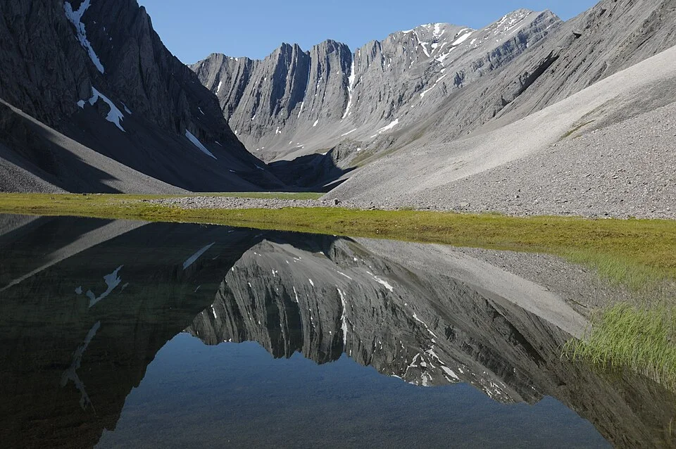
A tarn in Oolah Valley, Gates of the Arctic National Park and Preserve, Alaska: a comparative glacial-landform example.
Credit: National Park Service, Alaska Region · Public domain · sourceResized and converted to WebP; uncropped.
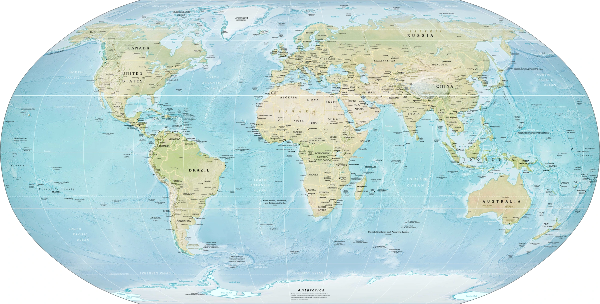
Map study
World physical relief: locate major mountain belts, plains and ocean basins. Regional orientation, not a detailed local landform survey.
- Read the source date and legend; distinguish territory, influence and geographic location.
- Historical boundaries and reference memberships are not live political or operational data.
Credit: US Government; Central Intelligence Agency · Public domain · sourceConverted to WebP on an opaque white background; proportionally resized without cropping. Original cartography and legend retained.
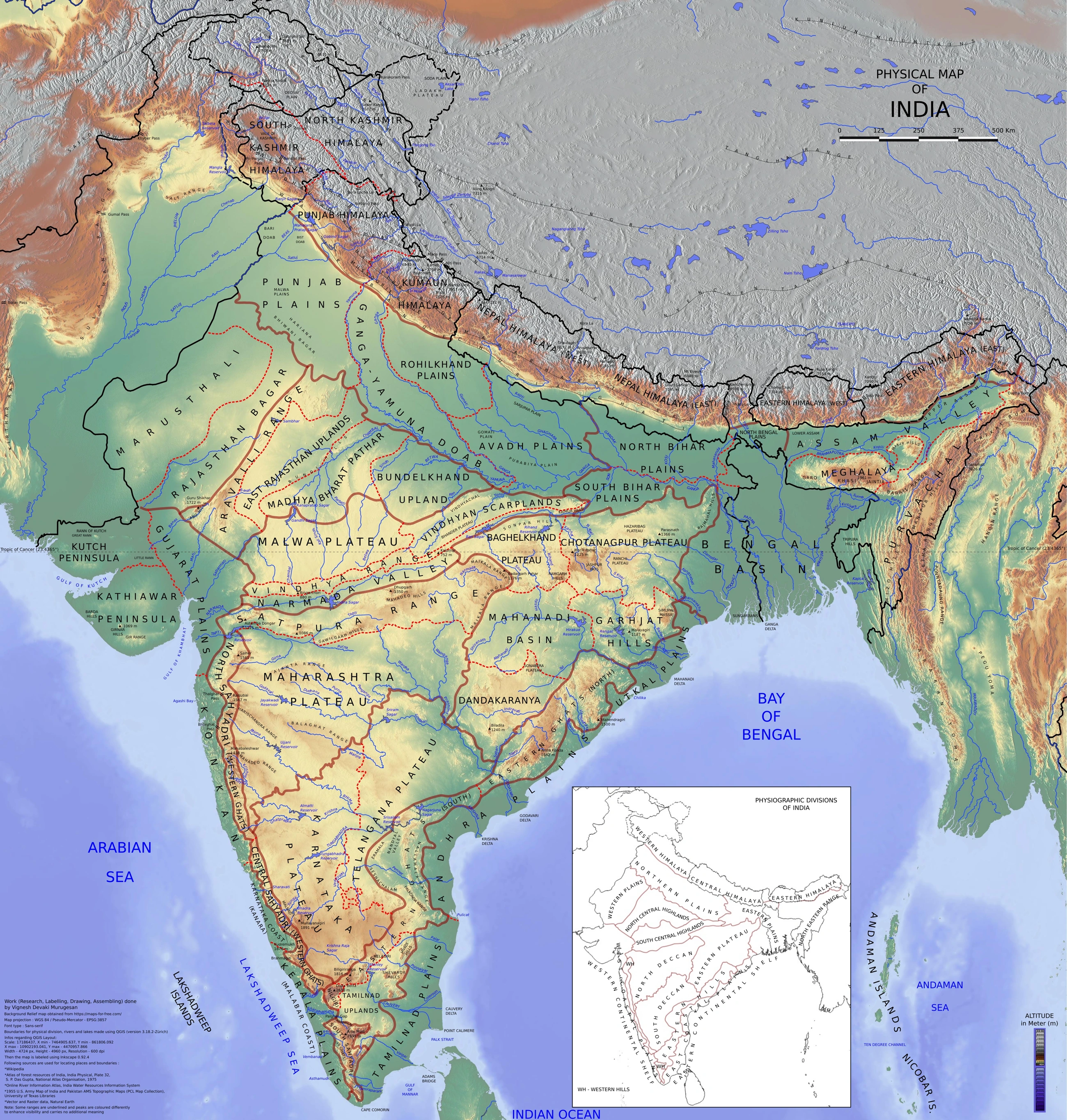
Map study
Physical divisions of India: locate mountains, plains, plateau, desert, coast and islands. Use regional relief to interpret landform processes; this is not a local geomorphological survey.
- Read the legend and reference date before interpreting regional patterns.
- Relate the map to the article’s topic; verify current administrative boundaries or data separately.
Credit: Vigneshdm1990 · CC BY-SA 4.0 · sourceConverted to WebP on an opaque white background; proportionally resized without cropping. Original cartography and legend retained.
1. Glaciers as geomorphic agents
Glaciers develop where accumulated snow survives successive melt seasons and is progressively compacted into firn and glacier ice. Valley glaciers occupy mountain valleys, while ice sheets spread across extensive land areas and may override much of the underlying relief. Antarctica and Greenland contain the present ice sheets. The Himalaya, Karakoram, Alps, Andes and Alaska support major mountain glacier systems.
Glacial mass balance is the difference between accumulation and ablation over a specified period. Accumulation includes snowfall and avalanche inputs; ablation includes melting, sublimation and, where relevant, calving. The equilibrium line separates zones of net annual accumulation and net annual ablation. Its position is influenced by temperature, snowfall, aspect and local topography rather than latitude alone.
Glaciers shape landscapes by eroding their beds, carrying sediment within, beneath and on top of the ice, and depositing it when transport capacity declines or ice melts. Moving ice is not equivalent to flowing water: it can transport particles ranging from clay to enormous boulders together. Meltwater then reworks part of this debris, producing distinctly different deposits.
- Temperate or warm-based ice commonly permits basal sliding and substantial erosion; cold-based ice frozen to its bed may preserve older surfaces.
- Periglacial processes occur in cold environments around or beyond glaciers and include frost action and solifluction; they do not require glacier movement.
2. Erosion and high-mountain landforms
Abrasion occurs when debris carried at the glacier base scrapes and grinds bedrock, producing polished surfaces, grooves, striations and fine rock flour. Quarrying, commonly called plucking, removes fractured bedrock blocks as moving ice interacts with bedrock and fluctuating basal water pressure. Freeze-thaw weathering helps supply debris from exposed valley walls but should not be treated as identical to glacial erosion.
A cirque, also called a corrie or cwm, is an amphitheatre-shaped hollow near the head of a glaciated valley. It typically has steep enclosing walls, an overdeepened floor and a threshold or rock lip. After ice melts, a small lake called a tarn may occupy the hollow. Not every tarn has the same origin, but cirque lakes are its classic geographical expression.
An arête is a sharp ridge separating adjacent cirques or glacial valleys. Where several cirques erode a mountain from different directions, a steep pyramidal peak or horn may remain. The Matterhorn in the Alps is the standard example. A col is a saddle or pass along a ridge; glacial headward erosion can contribute to its formation.
- Cirque: hollow; arête: ridge; horn: peak. These are related but not interchangeable.
- Striations indicate the alignment of former ice movement; determining its direction usually requires additional evidence.
Typical development of a deglaciated mountain valley
- 1. Persistent snow accumulation produces firn and glacier ice.
- 2. Ice flows downslope and entrains rock debris.
- 3. Abrasion and quarrying deepen and widen the valley.
- 4. Ice and meltwater transport and deposit sediment.
- 5. Negative mass balance causes the glacier margin to retreat.
- 6. A trough, moraines, exposed bedrock and possible lakes remain.
3. Glacial valleys and bedrock features
Valley glaciers widen, deepen and straighten pre-existing valleys, often transforming a river-cut V-shaped cross-section into a U-shaped glacial trough. Such troughs have steep sides and relatively broad floors. Interlocking river spurs may be cut back into truncated spurs. Glacial overdeepening can create rock basins that later hold ribbon lakes; however, lake shape alone does not establish a glacial origin.
A hanging valley is a tributary valley whose floor remains above that of the main glacial trough. It commonly develops because the larger trunk glacier excavates more deeply than its tributary. After deglaciation, a stream entering the main valley may descend as a waterfall. Yosemite Valley in the United States provides well-known examples of glacial troughs and hanging tributaries.
A roche moutonnée is an asymmetric bedrock knob, typically with a smooth, gently sloping upstream or stoss face and a rough, steeper downstream or lee face. Abrasion dominates the stoss side, while quarrying is characteristic of the lee. A fjord forms where the sea inundates a glacial trough, often producing a deep, steep-sided inlet with a shallower threshold near its mouth. Norway provides classic examples.
- Distinguish a fjord, which occupies a glacial valley, from a ria, which occupies a drowned river valley.
- A roche moutonnée is an eroded bedrock feature, whereas a drumlin is generally a streamlined sediment landform.
| Feature | Dominant origin | Diagnostic characteristic |
|---|---|---|
| Roche moutonnée | Bedrock erosion | Smooth stoss face and rough, steep lee face |
| Drumlin | Subglacial sediment shaping | Streamlined hill aligned with ice flow |
| Moraine | Accumulation of glacial debris | Typically poorly sorted material marking margins or former glacier beds |
| Esker | Ice-confined meltwater deposition | Sinuous ridge of sorted sand and gravel |
| Outwash plain | Meltwater deposition beyond ice margin | Broad, stratified deposits crossed by braided channels |
| Kettle | Melting of stranded ice | Depression, sometimes occupied by a lake |
4. Glacial and fluvioglacial deposition
Till is deposited directly by glacier ice and is typically unsorted and unstratified, with mixed particle sizes. Moraine refers to accumulations or landforms of glacial debris rather than a single sediment size. Lateral moraines occur along glacier margins; medial moraines commonly develop where tributary glaciers merge and their adjoining lateral debris bands unite.
Terminal or end moraines mark a former ice-margin position; the terminal moraine commonly denotes the farthest advance in a particular glacial episode. Recessional moraines mark pauses or minor readvances during overall retreat. Ground moraine is a spread of till left beneath or behind ice. An erratic is a glacier-transported rock whose lithology differs from the local bedrock, providing clues to transport pathways.
Drumlins are streamlined hills commonly composed largely of till, sometimes with bedrock cores. Their long axes generally parallel former ice flow; the classic form has a blunt upstream end and a tapered downstream tail. Their formation is complex and may involve sediment deformation and erosion as well as deposition, so they should not be reduced to a single universal mechanism.
Meltwater sorts and stratifies sediment. Eskers are long, winding ridges of sand and gravel deposited by streams flowing within or beneath ice. Kames are irregular mounds of ice-contact sand and gravel. Outwash plains, or sandurs, form beyond glacier margins through braided meltwater streams. Kettle holes develop when buried or partly buried stagnant ice blocks melt; water-filled depressions become kettle lakes.
- Varves are paired seasonal sediment layers, commonly found in glacial lakes; coarser summer and finer winter layers can preserve annual records.
- A sinuous ridge suggests an esker, not a former surface river valley: sediment accumulated in an ice-confined channel and remained after melting.
5. Indian distribution, hazards and interpretation
Indian glacial landscapes occur mainly in the Himalaya and Karakoram. Gangotri Glacier lies in Uttarakhand, Zemu Glacier in Sikkim and Siachen Glacier in the eastern Karakoram. The Bhagirathi emerges at the Gangotri glacier terminus near Gaumukh. Moraines, glacial troughs and lake basins help reconstruct earlier glacier extents even where present ice has retreated.
Moraines may impound proglacial lakes, but such dams can contain loose sediment and buried ice. Overtopping waves, slope failures, intense inflows or internal erosion can contribute to a glacial lake outburst flood. Not every glacial lake is moraine-dammed: lakes also occupy bedrock basins or are dammed by ice. Hazard assessment therefore requires dam composition, lake geometry, surrounding slopes and downstream exposure.
For Prelims, classify features first by dominant agent and process. Contrast direct ice deposition with meltwater deposition, and distinguish a surviving landform from evidence of active glaciation. Ancient glacial features can persist in presently temperate regions. Remote sensing, field mapping, sediment analysis and dating of exposed rocks are used together to reconstruct glacier history.
- Glacier retreat does not automatically imply immediate river drying: runoff responses vary with season, precipitation and the stage of glacier loss.
- In mountain hazards, avoid labelling every debris flow or flash flood a glacial lake outburst flood without evidence of lake drainage.
Tarns and the legacy of glacial erosion
The supplied metadata identifies a small tarn in Oolah Valley, Alaska. A tarn is a mountain lake commonly occupying a basin excavated by glacial erosion, often within a cirque. Moving ice erodes bedrock through abrasion by embedded debris and through plucking of fractured rock. Where erosion deepens a basin below its outlet, water can accumulate after ice retreats. A bedrock threshold or a depositional barrier may help retain the lake; the term tarn alone does not establish which mechanism formed its particular basin.
This Alaskan example provides comparative context, not evidence for an Indian site. In the Himalaya, cirques, overdeepened valleys and glacial lakes help explain how former ice extent shaped present drainage and relief. However, not every high-altitude lake is a tarn, and glacial lakes may occupy erosional basins or be impounded by moraines or ice. The metadata does not establish this lake’s basin geometry, dam material, age or formation history. Such interpretations require geomorphological mapping and field evidence rather than a place-name or scenic description.
- Distinguish landform from water body: a cirque is an amphitheatre-like erosional hollow; a tarn is a lake that may occupy its floor.
- Separate processes: bedrock overdeepening is erosional, whereas moraine construction is depositional; either can contribute to a glacial lake setting.
- For Himalayan hazard analysis, a glacial lake does not automatically imply imminent outburst risk; dam stability, drainage and possible triggers require assessment.
Real-world case studies
South Lhonak Lake, Sikkim, 2023
On 4 October 2023, an outburst from South Lhonak glacial lake generated destructive flooding along the Teesta system. The event illustrates the interaction of an expanding moraine-dammed lake, unstable high-mountain terrain and vulnerable downstream infrastructure. It underlines the need for repeated lake monitoring, slope assessment, early warning and basin-wide planning.
Norway’s fjord landscape
Geirangerfjord and Nærøyfjord, included in UNESCO’s West Norwegian Fjords World Heritage property, display steep-sided, sea-flooded glacial troughs. Their landscape demonstrates how glacial excavation followed by marine inundation produces fjords, distinguishing them from drowned river valleys.
Previous year questions
No source-linked PYQ is available here yet. Use the practice questions below.
Practice questions
Practice MCQ 1
Consider the following pairs: 1. Arête — Sharp ridge between glacial hollows or valleys; 2. Esker — Ridge deposited by ice-confined meltwater; 3. Roche moutonnée — Hill composed exclusively of sorted sand. Which pairs are correctly matched?
- A. 1 and 2 only
- B. 2 and 3 only
- C. 1 and 3 only
- D. 1, 2 and 3
Practice MCQ 2
Which of the following best distinguishes an outwash deposit from typical glacial till?
- A. Outwash is always composed only of clay.
- B. Outwash is generally sorted and stratified by flowing water.
- C. Till is deposited exclusively in glacial lakes.
- D. Till cannot contain large boulders.
Practice MCQ 3
Consider the following statements: 1. A hanging valley may result from stronger erosion by a trunk glacier than by a tributary glacier. 2. Glacier retreat necessarily means that ice flows uphill. 3. A fjord occupies a sea-flooded glacial trough. Which statements are correct?
- A. 1 only
- B. 2 and 3 only
- C. 1 and 3 only
- D. 1, 2 and 3
Mains practice · Explain how glacial and fluvioglacial processes produce contrasting landforms. Discuss the significance of these landforms for hazard assessment in the Indian Himalaya. Answer in 250 words.
- Define glacial erosion, direct ice deposition and meltwater deposition.
- Explain cirques, U-shaped valleys and roches moutonnées through abrasion and quarrying.
- Contrast till and moraines with sorted esker and outwash deposits.
- Discuss moraine-dammed lakes, unstable slopes and outburst-flood pathways.
- Use South Lhonak as an example and recommend monitoring, warning systems and risk-sensitive infrastructure.
Further reading
- NCERT, Fundamentals of Physical Geography, Class XI: Geomorphic Processes; Landforms and their Evolution.
- G. C. Leong, Certificate Physical and Human Geography: glaciation.
- National Disaster Management Authority, Guidelines on Management of Glacial Lake Outburst Floods, 2020.
- Geological Survey of India: publications on Himalayan glaciers and glacial geology.
- UNESCO World Heritage Centre: West Norwegian Fjords – Geirangerfjord and Nærøyfjord.
- https://commons.wikimedia.org/wiki/File:Oolah_Valley_(16089307144).jpg
Preparing for UPSC Civil Services? Get classroom teaching, answer-writing evaluation and mentorship at Pragnya IAS Academy, Ashok Nagar — see why aspirants choose us for IAS coaching in Hyderabad.