
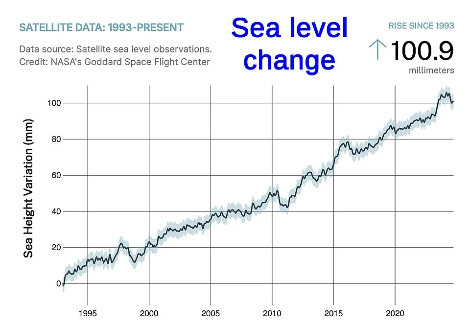
Satellite sea-level observations beginning in 1993, illustrating measurement of sea-level change.
Credit: NASA · Public domain · sourceResized and converted to WebP; uncropped.
1. Meaning, measurement and essential distinctions
Sea level is not a fixed, uniformly flat surface. Tides, atmospheric pressure, winds, currents, temperature and salinity produce variations over hours to decades. Sea-level rise refers to a persistent increase after these shorter-term fluctuations are accounted for. Global mean sea level is the spatial average of ocean-surface height; regional and local trends may differ substantially from this average.
Absolute, or geocentric, sea level describes ocean height relative to an Earth-centred reference frame. Relative sea level describes the sea surface relative to the land at a particular coast. Tide gauges primarily record relative sea level, whereas satellite radar altimeters measure sea-surface height in a geocentric reference frame. Satellite altimetry has provided near-global observations since 1993.
Measurements are combined to identify causes. Satellite gravimetry, including GRACE and GRACE Follow-On, tracks changes in ice and water mass. Argo profiling floats measure ocean temperature and salinity, helping estimate expansion-related changes. GNSS observations near tide gauges help distinguish ocean rise from vertical land movement.
- Eustatic change traditionally refers to global sea-level change associated with changes in ocean-water volume or ocean-basin capacity.
- Steric change results from changes in seawater density: thermosteric change concerns temperature, while halosteric change concerns salinity.
- A storm surge is a short-lived abnormal rise caused mainly by storm winds and atmospheric pressure; it is not the same as long-term sea-level rise.
2. Physical causes and uneven regional patterns
Thermal expansion occurs because seawater generally occupies more volume as it warms. The ocean absorbs most of the excess heat accumulating in the climate system, and warming can penetrate progressively into deeper layers. Expansion therefore continues beyond the initial atmospheric warming. IPCC AR6 attributed approximately half of the observed global mean rise during 1971–2018 to thermal expansion.
The second major mechanism is transfer of water from land to ocean. Mountain glaciers and the Greenland and Antarctic ice sheets lose mass through surface melting, runoff and ice discharge. Floating sea ice already displaces approximately its own weight of seawater, so its melting makes a negligible direct contribution. However, sea-ice loss reduces reflectivity, while thinning or collapse of floating ice shelves can weaken their buttressing effect and accelerate the discharge of grounded ice.
Terrestrial water storage also matters. Groundwater extraction can transfer previously stored water into the ocean through runoff and the water cycle, whereas reservoir impoundment stores water on land. Over geological timescales, tectonic changes in ocean-basin capacity also influence sea level.
Rise is geographically uneven because winds, ocean currents, density changes and gravitational effects redistribute water. Ice-sheet mass loss changes the gravitational attraction exerted on nearby seawater and deforms the solid Earth, producing distinct sea-level fingerprints. Meanwhile, groundwater withdrawal, sediment compaction and reduced sediment replenishment can lower coastal land. Tectonic uplift and post-glacial rebound can instead reduce or reverse local relative sea-level rise.
- Subsidence and sea-level rise are distinct processes, but both increase relative sea level.
- Glacial isostatic adjustment is the continuing response of the Earth to past loading and unloading by ice sheets.
- No single global rate should be applied mechanically to every Indian coastal settlement.
From greenhouse warming to increased coastal risk
- 1. Greenhouse gases increase planetary heat retention
- 2. Oceans warm and land-based ice loses mass
- 3. Seawater expands and additional water enters the ocean
- 4. Global sea-level rise is modified locally by circulation and land motion
- 5. Higher baseline water levels amplify flooding, erosion and salinisation
- 6. Mitigation and location-specific adaptation reduce future risk
3. Observed trends, projections and long-term commitment
IPCC AR6 reported a global mean rise of about 0.20 metre during 1901–2018. The average rate increased from 1.3 mm per year during 1901–1971 to 1.9 mm during 1971–2006 and 3.7 mm during 2006–2018. These figures show acceleration rather than a constant linear trend. Individual years may depart from the long-term trend because phenomena such as El Niño and La Niña alter ocean heat and terrestrial water storage.
Relative to 1995–2014, the likely rise by 2100 is 0.28–0.55 metre under the very low-emissions scenario SSP1-1.9 and 0.63–1.01 metres under the very high-emissions scenario SSP5-8.5. These are conditional projections, not fixed predictions. Uncertain ice-sheet processes create additional risks beyond the likely ranges.
Sea level responds slowly to changes in climate. Deep-ocean warming and ice-sheet adjustment mean that rise will continue for centuries to millennia even after temperatures stabilise. Strong mitigation reduces its eventual magnitude and rate but does not immediately stop it. Coastal planning must therefore consider both near-term observations and longer-term commitments.
- Always identify the projection’s baseline period, target year, emissions scenario and uncertainty range.
- Global mean projections must be combined with local land motion and regional ocean conditions for adaptation planning.
| Process | Mechanism | Effect |
|---|---|---|
| Thermal expansion | Warming reduces seawater density | Raises global mean sea level |
| Land-ice loss | Water moves from glaciers and ice sheets to ocean | Raises global mean sea level |
| Floating sea-ice melt | Ice already displaces seawater | Negligible direct contribution |
| Coastal subsidence | Land sinks through compaction, extraction or tectonics | Raises local relative sea level |
| Storm surge | Storm winds and pressure elevate coastal water | Temporary rise superimposed on mean sea level |
4. Coastal impacts and Indian vulnerability
A higher mean sea level raises the starting point for tides, storm surges and wave action. Consequently, an extreme water level that was formerly rare may occur more frequently even without stronger storms. Impacts include permanent inundation of some lowlands, more frequent coastal flooding, shoreline retreat, impaired drainage and saltwater intrusion into rivers, soils and aquifers.
Vulnerability depends on exposure and adaptive capacity, not elevation alone. Deltas are particularly sensitive because they combine low relief, compressible sediments and dense settlement. Upstream dams, embankments and sediment extraction may reduce sediment delivery, limiting the ability of delta surfaces to build upward. Mangroves and tidal wetlands can accumulate sediment or migrate inland, but rapid rise and development barriers may prevent adjustment.
In India, the Sundarbans and the Mahanadi, Godavari, Krishna and Cauvery delta regions warrant attention, alongside low-lying urban coasts and island territories. Mumbai and Chennai illustrate the importance of considering coastal water levels together with heavy rainfall and drainage constraints. Lakshadweep’s low-lying coral islands face risks to freshwater lenses, infrastructure and beaches. Nevertheless, shoreline erosion is not automatically proof of sea-level rise: ports, sand mining, waves and sediment deficits may also be responsible.
- Coastal squeeze occurs when intertidal habitats are trapped between rising seas and fixed landward barriers.
- Compound flooding combines interacting drivers such as heavy rainfall, river discharge, high tides and storm surge.
- Salinisation can affect drinking-water security and agriculture before land becomes permanently submerged.
5. Adaptation, mitigation and governance
Adaptation is commonly organised into protection, accommodation and retreat. Protection includes seawalls, surge barriers and ecosystem-based measures. Accommodation includes elevated buildings, flood-resilient infrastructure, improved drainage and suitable farming practices. Planned retreat moves people or assets away from persistently hazardous locations. Avoiding new development in exposed areas often prevents costly future dependence on defences.
Each approach involves trade-offs. Hard structures may protect valuable assets but disrupt sediment transport, intensify erosion elsewhere and require maintenance. Mangrove restoration and dune conservation provide ecological benefits, but their success depends on suitable hydrology, sediment supply and space. Nature-based measures complement rather than universally replace engineered protection.
India’s Coastal Regulation Zone framework, including the CRZ Notification, 2019 under the Environment (Protection) Act, 1986, regulates coastal activities and recognises sensitive areas. Integrated Coastal Zone Management promotes coordination across sectors. INCOIS supplies ocean information and coastal hazard services, while the National Centre for Coastal Research studies shoreline change and coastal processes. Effective planning combines such information with local surveys, community participation and periodic reassessment.
- Mitigation limits future warming; adaptation manages unavoidable impacts.
- Use flexible adaptation pathways with clear thresholds for upgrading defences or relocating assets.
- Prioritise vulnerable communities, livelihood continuity and fair compensation in relocation decisions.
Measuring Sea-Level Rise: Global Trends and Local Risk
The supplied metadata identifies a satellite sea-level observation record beginning in 1993, directly relevant to monitoring sea-level rise. Satellite radar altimeters estimate sea-surface height from the travel time of radar pulses, combined with precise knowledge of satellite position and necessary corrections. Repeated observations help establish changes in global mean sea level relative to a geocentric reference frame. However, the metadata alone does not establish the plotted trend, its magnitude or the record’s end date; these should not be inferred from the filename.
Global mean sea-level rise mainly reflects thermal expansion of warming seawater and the addition of water from melting glaciers and ice sheets on land. Local relative sea level can change differently because the coast itself may subside or rise, while currents and winds redistribute ocean water. This distinction matters for India’s coastal cities, deltas and islands: a global average cannot directly specify inundation at a particular shoreline. Tide gauges, land-motion measurements and coastal elevation data are needed alongside satellite observations. Higher mean sea level can worsen storm-surge flooding, erosion and salinity intrusion, but exposure also depends on coastal geomorphology, sediment supply and development.
- Measurement distinction: Tide gauges measure sea level relative to nearby land; satellite altimetry measures sea-surface height in a geocentric reference frame.
- Prelims trap: Melting floating sea ice has little direct effect on sea level; melting land ice adds ocean water.
- Mains application: Indian coastal adaptation needs local risk assessments; combine ecosystem protection, development controls and suitable engineered measures.
Real-world case studies
Indian Sundarbans: interacting deltaic risks
The Indian Sundarbans in West Bengal experience tidal-channel migration, erosion, cyclonic flooding and salinity stress. Relative sea-level rise interacts with sediment dynamics, embankments and local land movement. Cyclone Amphan in 2020 illustrated the consequences of saline inundation and embankment failure. The lesson is to combine mangrove conservation, embankment management and livelihood adaptation rather than attribute every local land loss solely to global sea-level rise.
The Netherlands: adaptive delta planning
The Dutch Delta Programme combines flood protection, freshwater management and climate-resilient spatial planning. The Delta Works provide major engineered protection, while Room for the River demonstrates the value of allowing floodwater more space. Together, these approaches illustrate integrated management of coastal and river risks, supported by long-term funding and periodic revision rather than a one-time infrastructure solution.
Previous year questions
Source-linked detailed analyses are available above.
Practice questions
Practice MCQ 1
Which of the following directly contribute to an increase in global mean sea level? 1. Thermal expansion of seawater 2. Melting of mountain glaciers 3. Subsidence of land at a particular coastal city Select the correct answer.
- A. 1 and 2 only
- B. 2 and 3 only
- C. 1 and 3 only
- D. 1, 2 and 3
Practice MCQ 2
Consider the following statements: 1. Tide gauges record sea level relative to adjacent land. 2. Satellite altimetry measures sea-surface height using an Earth-centred reference frame. 3. Melting floating sea ice contributes approximately as much directly to sea-level rise as an equal mass of melting land ice. Which statements are correct?
- A. 1 only
- B. 2 and 3 only
- C. 1 and 2 only
- D. 1, 2 and 3
Practice MCQ 3
What best explains coastal squeeze?
- A. Compression of deep-ocean water under increasing pressure
- B. Loss of intertidal habitat between rising seas and barriers preventing inland migration
- C. Narrowing of an ocean basin by convergent plate movement
- D. Temporary withdrawal of seawater before some tsunamis
Mains practice · Sea-level rise is global in origin but locally differentiated in its consequences. Explain with reference to Indian coasts and suggest an integrated adaptation strategy. Answer in 250 words.
- Explain thermal expansion and land-ice loss as major global drivers.
- Distinguish absolute sea-level rise from relative change caused by land motion.
- Discuss circulation, sediment supply, delta subsidence and coastal development.
- Use the Sundarbans, urban coasts and Lakshadweep as contrasting examples.
- Address compound flooding, salinisation, habitat loss and unequal vulnerability.
- Combine development controls, ecosystem restoration, resilient infrastructure and planned retreat.
- Conclude with sustained monitoring, flexible planning and emissions mitigation.
Further reading
- NCERT, Fundamentals of Physical Geography, Class XI: Water (Oceans) and Movements of Ocean Water.
- IPCC, Climate Change 2021: The Physical Science Basis, Summary for Policymakers and Chapter 9.
- IPCC, Special Report on the Ocean and Cryosphere in a Changing Climate, 2019.
- INCOIS official website: ocean observations and coastal hazard services.
- National Centre for Coastal Research: shoreline-change assessments.
- Ministry of Environment, Forest and Climate Change: Coastal Regulation Zone Notification, 2019.
- https://commons.wikimedia.org/wiki/File:NASA-Satellite-sea-level-rise-observations.jpg
Preparing for UPSC Civil Services? Get classroom teaching, answer-writing evaluation and mentorship at Pragnya IAS Academy, Ashok Nagar — see why aspirants choose us for IAS coaching in Hyderabad.