
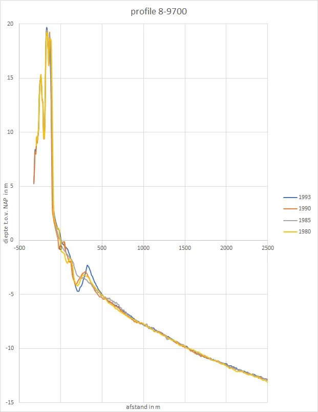
Coastal profile at Meijendel, Netherlands, based on Rijkswaterstaat’s JARKUS data; a comparative example.
Credit: Henk Jan Verhagen · CC BY-SA 4.0 · sourceResized and converted to WebP; uncropped.
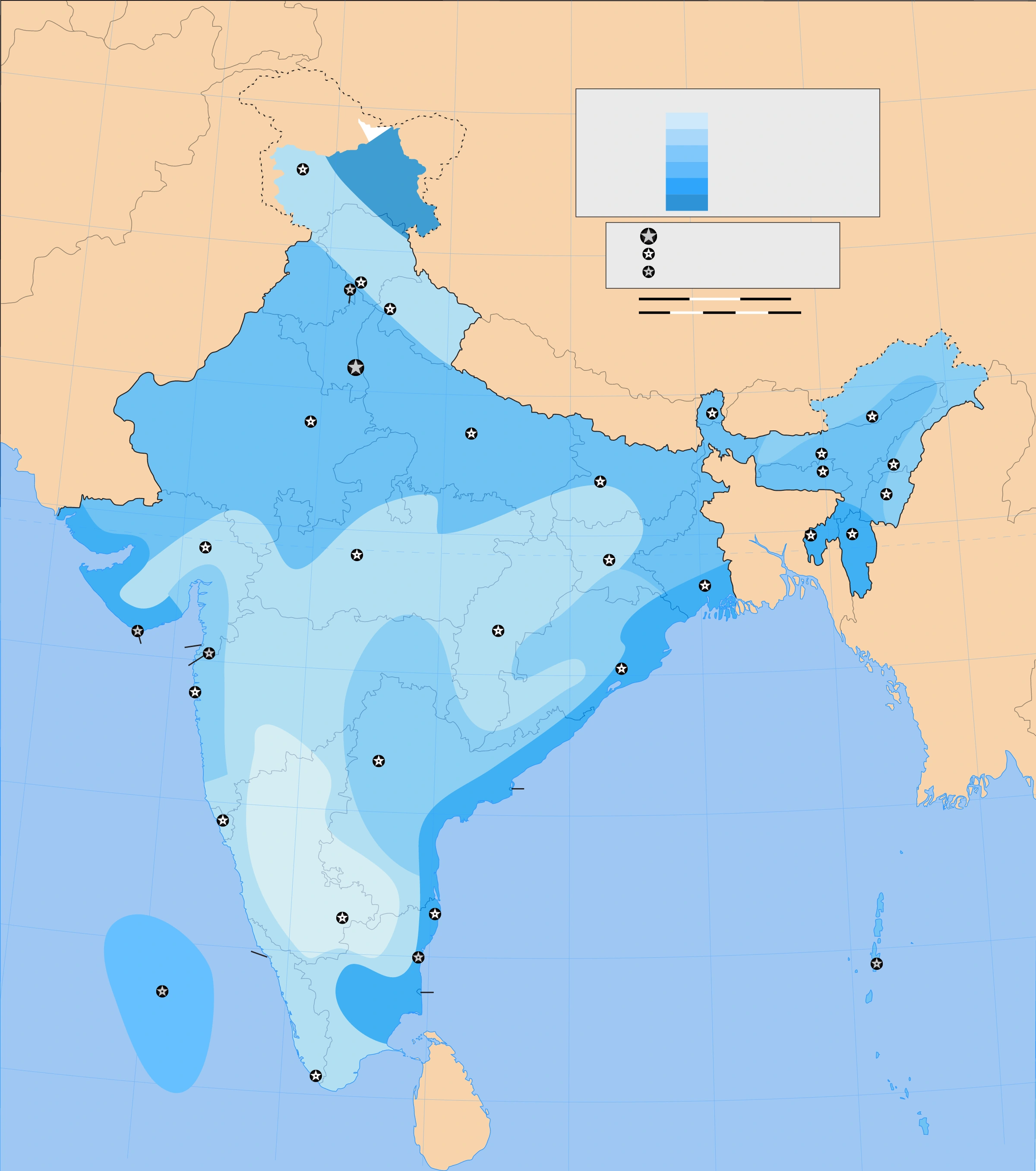
Map study
Wind and cyclone-risk reference zones: compare east coast, west coast and inland areas. Current official forecasts must guide operational decisions.
- Read the source legend and reference date before interpreting the map.
- Use spatial patterns to support topic revision; verify current official boundaries, designations and warnings separately.
Credit: Planemad · CC BY-SA 3.0 · sourceConverted to WebP on an opaque white background; proportionally resized without cropping. Original cartography and legend retained.
1. The coast as a dynamic system
A coast is a transition zone shaped by marine processes, terrestrial sediment supply, geological structure and biological activity. Its form depends on rock resistance, coastal slope, wave exposure, tidal range and the availability of sediment. The shoreline is not a permanently fixed boundary: its observed position changes with tides, storms and seasons. Long-term shoreline change therefore requires comparison of consistent indicators over sufficiently long periods.
A useful organising concept is the sediment budget: the balance between sediment entering, being stored within and leaving a coastal segment. Rivers, eroding cliffs, offshore deposits and wind may supply material. Longshore currents, offshore transport, dredging and sand extraction may remove it. A persistent deficit commonly causes erosion, whereas a surplus supports accretion, although local engineering and geology also matter.
A littoral cell is a coastal sediment-transport compartment with sources, pathways and sinks. Headlands, estuaries or submarine canyons may partly bound such cells. Because neighbouring beaches can share sediment, protecting one location may increase erosion elsewhere. Shoreline retreat must also be distinguished from temporary inundation: the former is landward displacement of the shoreline, while the latter is flooding that may subsequently recede.
- Principal controls: geology, waves, tides, currents, sediment supply and relative sea level.
- Prelims distinction: coastal erosion removes material; coastal flooding covers land with water.
2. Waves, tides and coastal sediment transport
Wind-generated wave characteristics depend principally on wind speed, duration and fetch, the uninterrupted distance over which wind blows. In deep water, water particles move in approximately circular orbits that diminish with depth. As waves enter shallow water, seabed interaction reduces their speed and wavelength; their height commonly increases through shoaling until they become unstable and break. The uprush on a beach is swash, and the returning flow is backwash.
Wave refraction is the bending of wave crests caused by differences in propagation speed over varying depths. The shallower part of a wave slows first. Along an irregular coast this usually concentrates wave energy around headlands and spreads it across bays, encouraging headland erosion and deposition in sheltered areas. Local seabed configuration can modify this pattern.
When waves break obliquely, swash carries sediment diagonally up the beach while gravity-driven backwash returns it more directly downslope. Together with wave-generated longshore currents, this produces alongshore sediment transport. Cross-shore transport redistributes material between beaches and offshore bars. Steep storm waves commonly move sand offshore; gentler conditions may return some of it. Tidal currents are particularly important in estuaries and inlets, whereas rip currents are narrow seaward flows, not tides.
- Spring tides occur around new and full moon; neap tides occur around the first and third quarters.
- Constructive and destructive waves are useful textbook categories, but actual beach response also depends on sediment size, slope and antecedent conditions.
How a sediment-trapping coastal structure can shift erosion
- 1. Waves generate net longshore sediment transport.
- 2. A groyne or harbour breakwater interrupts part of that transport.
- 3. Sediment accumulates on the updrift side.
- 4. Sediment supply to the downdrift coast decreases.
- 5. A sediment deficit may cause beach narrowing and shoreline retreat.
- 6. Sediment bypassing, nourishment or structural redesign may be needed.
3. Erosion and its characteristic landforms
Marine erosion operates through hydraulic action, abrasion and solution. Hydraulic action involves wave impact and pressure changes, including compression of air in rock joints. Abrasion occurs when transported sand and pebbles scour the coast. Solution is chemical dissolution, especially important in susceptible rocks such as limestone. Attrition differs from abrasion: transported fragments collide with one another and become smaller and more rounded.
Repeated wave attack can excavate a notch near the foot of a cliff. Undercutting and weathering weaken the overlying rock, which may collapse through rockfall or other mass movements. Cliff retreat can leave a gently sloping wave-cut platform, often exposed at low tide. Its development reflects wave action, rock structure, weathering and sea-level history rather than a single process.
On jointed headlands, waves can enlarge weaknesses into caves. A cave may extend through a headland to form an arch; roof collapse can leave an isolated stack, later reduced to a stump. This is a common explanatory sequence, not a compulsory evolution for every rocky coast. Alternating resistant and weak rocks can produce headlands and bays through differential erosion. Beaches within bays may subsequently dissipate wave energy and limit further erosion.
- Rock structure matters: joints, faults, bedding and lithology influence the position and rate of erosion.
- Marine erosion and subaerial weathering commonly act together; cliffs are not shaped by waves alone.
| Landform | Defining feature | Dominant process |
|---|---|---|
| Spit | Ridge attached to land at one end | Alongshore sediment transport and deposition |
| Tombolo | Sediment ridge connecting an island to land or another island | Deposition influenced by local wave transformation |
| Barrier island | Elongated island separated from the mainland by a lagoon or marsh | Sediment redistribution by waves, tides and storms |
| Ria | Drowned river valley, often branching | Relative sea-level rise |
| Fjord | Drowned, steep-sided glacial valley | Glacial erosion followed by marine inundation |
| Wave-cut platform | Gently sloping rock surface adjoining a retreating cliff | Marine erosion and cliff retreat |
4. Deposition, coastal ecosystems and sea-level change
Deposition occurs when transporting agents lose the capacity to carry sediment. Beaches are accumulations of sand, gravel or other loose material within the active coastal zone. A spit is a narrow depositional ridge attached to land at one end, commonly extending across an inlet where longshore transport continues beyond a change in coastline direction. Its distal end may curve because of changing wave directions and currents.
A baymouth bar extends across a bay entrance, while a tombolo connects an island to the mainland or another island. Barrier islands are elongated sedimentary bodies separated from the mainland by lagoons or marshes. Lagoons are shallow coastal water bodies partly or largely isolated from the open sea. Tidal flats form where fine sediment accumulates under suitable low-energy conditions; vegetation can promote sediment trapping in salt marshes and mangroves.
Wind can transfer dry beach sand inland to form coastal dunes, whose vegetation helps stabilise sediment. Dunes also provide sand reserves during storms. Emergent coasts reflect relative sea-level fall and may display raised beaches or marine terraces. Submergent coasts reflect relative sea-level rise: rias are drowned river valleys, while fjords are drowned glacial valleys. Relative sea level can rise because the ocean rises, the land subsides, or both.
- A delta forms where river-borne sediment accumulation builds land at a river mouth; not every river mouth develops a delta.
- An estuary is a coastal water body with marine connection and mixing of seawater with land-derived freshwater.
5. Indian coastal hazards and management
India’s coasts illustrate contrasting process regimes. Strong tidal currents influence the Gulfs of Khambhat and Kachchh, while major east-coast rivers support extensive deltaic environments. Monsoon-driven changes in waves and currents cause pronounced seasonal beach fluctuations. Tropical cyclones add storm surge and energetic waves; surge is an abnormal meteorological rise in sea level, distinct from astronomical tide. Tsunamis are also distinct, usually originating from sudden displacement of the seabed.
Human activities can disrupt sediment budgets. Dams may reduce downstream sediment delivery; river and beach sand mining remove material; harbours and breakwaters can intercept longshore transport. Groundwater extraction and sediment compaction can intensify relative sea-level rise through subsidence. The National Centre for Coastal Research assessed about 6,907 km of mainland coastline for 1990–2016 and classified 33.6 per cent as eroding, illustrating that shoreline behaviour varies substantially along India’s coast.
Management combines hazard mapping, development setbacks, ecosystem conservation and selective engineering. Seawalls protect assets locally but can increase reflection and toe scour. Groynes trap alongshore-moving sediment but may starve downdrift beaches. Beach nourishment replenishes sand but requires suitable material and periodic renewal. Coastal Regulation Zone notifications under the Environment (Protection) Act, 1986 regulate coastal activities. Integrated coastal management should evaluate the whole sediment cell and favour long-term risk reduction over isolated structures.
- Soft approaches include dune restoration, wetland protection and beach nourishment.
- Hard structures should be assessed for effects on neighbouring shorelines, habitats and fishing access.
Coastal Profiles and Sediment Exchange
The metadata identifies this image as a coastal profile at Meijendel, derived from the Dutch Rijkswaterstaat’s JARKUS dataset. It is directly relevant to understanding how coastal form relates to sediment movement. A coastal profile represents changes in elevation or depth along a transect. Repeated measurements along the same transect can reveal beach lowering, sediment accumulation and redistribution between the upper beach and nearshore zone. However, the supplied metadata does not establish the measurement dates, profile orientation or whether multiple surveys are included.
Cross-shore sediment transport helps explain why a beach may narrow during energetic wave conditions and recover when gentler waves move sediment landward. Longshore transport, by contrast, redistributes sediment along the coast, commonly driven by waves approaching obliquely. For India, these distinctions help analyse monsoon-related beach variability and the effects of ports, groynes and breakwaters on sediment supply. Meijendel provides a comparative framework, not direct evidence about any Indian shoreline; local surveys and wave, tide and sediment observations remain essential.
- Profile change is not automatically permanent erosion: temporary offshore storage can occur within the coastal sediment system.
- A single profile cannot establish a long-term trend; comparable repeated surveys must account for seasonal variability and measurement reference levels.
- Shoreline position and sediment volume are different indicators. Tidal stage can shift the observed waterline without demonstrating a net sediment loss.
Real-world case studies
Puducherry: harbour development and sediment interruption
Harbour breakwaters constructed in the late 1980s interrupted longshore sand transport along the Puducherry coast. Updrift accumulation and severe downdrift erosion illustrate how infrastructure can redistribute, rather than eliminate, coastal risk. Subsequent beach-restoration initiatives have combined engineering interventions with nourishment. The lesson is to examine the regional sediment budget before selecting local protection measures.
Odisha: mangroves and cyclone protection
Research following Odisha’s 1999 super cyclone associated mangrove presence with reduced losses in some coastal settlements after accounting for other relevant factors. Mangrove roots and stems can dissipate flow energy and retain sediment. However, protection varies with forest width, density, topography and storm intensity. Mangrove conservation must complement, not replace, cyclone shelters, warnings and evacuation.
Previous year questions
No source-linked PYQ is available here yet. Use the practice questions below.
Practice questions
Practice MCQ 1
With reference to wave refraction, consider the following statements: 1. The part of a wave entering shallower water generally slows first. 2. Wave energy generally becomes concentrated around headlands. 3. Refraction necessarily causes erosion throughout every bay. Which of the statements given above are correct?
- A. 1 and 2 only
- B. 2 and 3 only
- C. 1 and 3 only
- D. 1, 2 and 3
Practice MCQ 2
Which one of the following pairs is correctly matched?
- A. Tombolo — Drowned glacial valley
- B. Ria — Sedimentary ridge connecting an island to the mainland
- C. Spit — Depositional ridge attached to land at one end
- D. Wave-cut platform — Wind-deposited sand ridge
Practice MCQ 3
A harbour breakwater interrupts a coast with persistent net northward longshore sand transport. In the absence of effective sediment bypassing, which outcome is most likely?
- A. Sand accumulation to the north and erosion to the south
- B. Sand accumulation to the south and increased erosion risk to the north
- C. Equal sand accumulation on both sides regardless of sediment supply
- D. Permanent cessation of all cross-shore sediment movement
Mains practice · Coastal erosion is a sediment-budget problem as much as a wave-energy problem. Explain with Indian examples and suggest an integrated management approach. Answer in 250 words.
- Define the sediment budget and relate erosion to persistent sediment deficits.
- Explain wave attack, seasonal cross-shore transport, longshore drift and relative sea-level change.
- Discuss reduced river sediment supply, sand extraction and harbour-induced interruption of transport.
- Use Puducherry to illustrate updrift accumulation and downdrift erosion.
- Compare seawalls and groynes with nourishment, sediment bypassing and ecosystem restoration.
- Recommend sediment-cell-based planning, shoreline monitoring, setbacks, community participation and hazard preparedness.
Further reading
- NCERT, Fundamentals of Physical Geography, Class XI: Landforms and their Evolution; Movements of Ocean Water.
- NCERT, India: Physical Environment, Class XI: Structure and Physiography.
- National Centre for Coastal Research, Ministry of Earth Sciences: National Assessment of Shoreline Changes along Indian Coast, 1990–2016.
- Ministry of Environment, Forest and Climate Change: Coastal Regulation Zone Notification, 2019, and subsequent amendments.
- Indian National Centre for Ocean Information Services: ocean-state forecasts, high-wave alerts and tsunami information.
- https://commons.wikimedia.org/wiki/File:Profile_8-9700-Meijendel.jpg
Preparing for UPSC Civil Services? Get classroom teaching, answer-writing evaluation and mentorship at Pragnya IAS Academy, Ashok Nagar — see why aspirants choose us for IAS coaching in Hyderabad.