
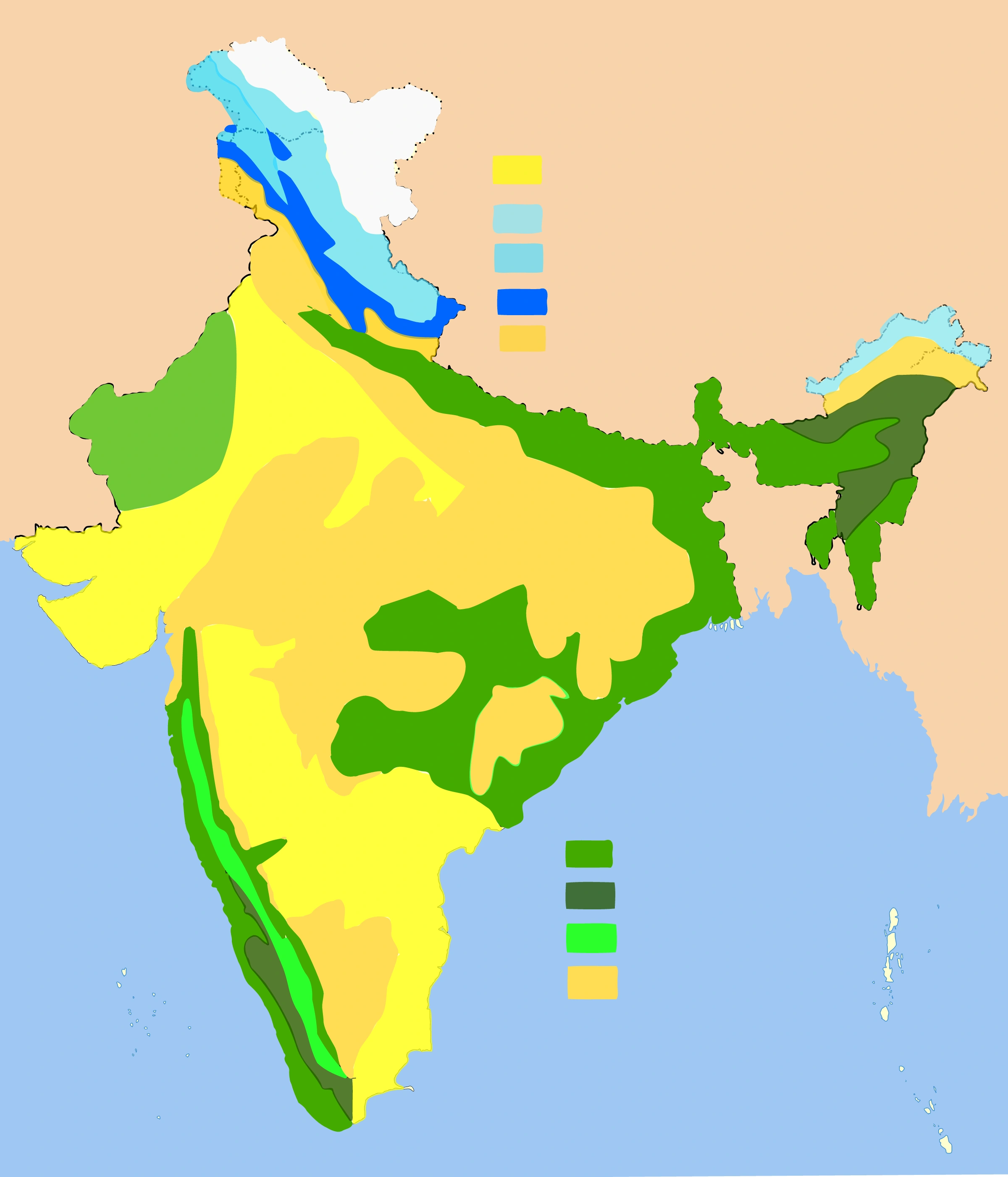
Map study
Natural vegetation zones: relate patterns to rainfall, relief and temperature. Potential natural vegetation differs from measured current forest cover.
- Read the source legend, scale and reference period before comparing regions.
- Connect spatial patterns to the processes discussed in this topic; this map is a study reference, not live operational data.
Credit: Amog · CC BY-SA 3.0 · sourceConverted to WebP on an opaque white background; proportionally resized without cropping. Original cartography and legend retained.
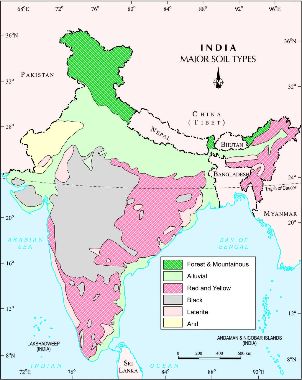
Map study
Major soil groups of India: NCERT reference map via NROER. Compare alluvial, black, red, lateritic and desert soils through the legend; local variation is finer than this national map.
- Read the legend and reference date before interpreting regional patterns.
- Relate the map to the article’s topic; verify current administrative boundaries or data separately.
Credit: NCERT via NROER · CC BY-SA 3.0 · sourceConverted to WebP on an opaque white background; proportionally resized without cropping. Original cartography and legend retained.
1. Soil formation, profile and classification
Soil is the biologically active upper part of the Earth’s crust in which mineral particles, organic matter, water, air and organisms interact. Weathering supplies mineral material, while vegetation and organisms contribute and transform organic matter. Pedogenesis includes additions, losses, transformations and movement of substances within the profile. Soil is therefore more than loose, weathered rock: its structure and horizons reflect continuing physical, chemical and biological processes.
The principal soil-forming factors are parent material, climate, organisms, relief and time. Parent material influences mineral composition and texture; rainfall and temperature regulate weathering, leaching and decomposition. Relief affects drainage and erosion: steep slopes generally support thinner soils, while lower slopes may accumulate transported material. Time allows horizons to develop, but repeated flooding or erosion can continually rejuvenate a soil.
A typical profile contains an organic-rich surface layer where present, an A horizon of mineral topsoil, a B horizon of accumulation or alteration, and a C horizon of relatively unweathered parent material above bedrock. Not every soil contains every horizon. Texture means the proportions of sand, silt and clay; structure means their arrangement into aggregates. Fertility is nutrient-supplying capacity, while productivity also depends on moisture, drainage, climate and management.
The eight traditional Indian soil groups are useful geographical categories, not exact equivalents of modern Soil Taxonomy orders. For example, many black soils are Vertisols, but the two terms are not universally interchangeable. ICAR’s National Bureau of Soil Survey and Land Use Planning, headquartered at Nagpur, undertakes soil resource assessment and land-use planning.
2. Alluvial and black soils: major agricultural foundations
Alluvial soils develop in river-deposited material and dominate the Indo-Gangetic-Brahmaputra plains. They also occur in river valleys and the eastern coastal deltas of rivers such as the Mahanadi, Godavari, Krishna and Kaveri. Their texture ranges from sandy deposits near channels to finer silts and clays in floodplains and deltas. They are generally poor in nitrogen and organic matter; potash and other nutrients vary with sediment provenance. Flood renewal does not automatically guarantee balanced fertility.
Khadar is newer alluvium deposited on active floodplains and commonly replenished by floods. Bhangar is older alluvium on relatively elevated terraces, usually beyond regular flood deposition; it may contain calcium carbonate concretions called kankar. These are geomorphic subdivisions of alluvium rather than separate soil orders. Rice, wheat, sugarcane, maize, pulses and jute are important crops on alluvial soils, depending on rainfall, irrigation and temperature.
Black soils, also called regur or black cotton soils, are prominent in Maharashtra, Madhya Pradesh, Gujarat and parts of Karnataka, Telangana and Andhra Pradesh. They are strongly associated with the basaltic Deccan region, although parent materials are not exclusively basaltic everywhere. Smectitic clays produce swelling when wet and shrinking when dry. Deep summer cracks aid aeration and mixing, explaining the familiar description of a self-ploughing soil.
Black soils retain substantial moisture and can support crops after the rainy season, but poor drainage and wet-season stickiness complicate cultivation. They are generally rich in lime, iron and magnesia, but often deficient in nitrogen, phosphorus and organic matter. Cotton is characteristic, not exclusive: soybean, sorghum, pulses and wheat are also cultivated. Moisture retention should not be confused with good aeration or universal nutrient sufficiency.
Diagnosing and managing a soil problem
- 1. Identify landform, parent material, rainfall and drainage
- 2. Sample soil and assess texture, pH, electrical conductivity and nutrients
- 3. Distinguish erosion, nutrient deficiency, acidity, salinity or sodicity
- 4. Select conservation measures and amendments suited to the diagnosis
- 5. Combine suitable cropping with water and nutrient management
- 6. Monitor soil condition and adjust practices
3. Red, lateritic, arid and mountain soils
Red and yellow soils commonly form over crystalline igneous and metamorphic rocks across the eastern and southern Deccan Plateau, Odisha, Chhattisgarh and adjoining regions. Iron oxides give the reddish colour; hydrated forms of iron compounds can produce yellowish shades. These soils range from coarse-textured upland soils to finer, more productive lowland soils. They are generally low in nitrogen, phosphorus and humus. Millets, groundnut, pulses and oilseeds are common, while irrigation and nutrient management permit wider crop choices.
Laterite soils occur in warm, humid regions with intense seasonal rainfall, including parts of the Western and Eastern Ghats, northeastern hills and plateau uplands. Leaching removes bases and silica, leaving relative concentrations of iron and aluminium compounds. Lateritic material may harden on exposure. These soils are often acidic and nutrient-poor; high rainfall does not imply high fertility. With suitable management, lateritic landscapes support cashew and plantation crops such as tea, coffee and rubber where other environmental requirements are met.
Arid soils occur chiefly in western Rajasthan and adjoining dry areas. They are often sandy, low in humus and moisture, and locally saline. Evaporation exceeds precipitation for much of the year, restricting leaching and encouraging salt or carbonate accumulation. Kankar horizons may impede infiltration. Irrigation can raise productivity, but inadequate drainage may create waterlogging and secondary salinity.
Forest and mountain soils vary sharply with altitude, slope, vegetation and rainfall. Valley bottoms may contain relatively deep, loamy deposits, whereas steep slopes have shallow, coarse soils. Humus-rich forest surfaces do not necessarily imply high available nutrients: cold conditions slow decomposition, and heavy rainfall can promote acidity and leaching. Mountain soil management must therefore be locally adapted rather than based on a single uniform category.
| Soil group | Main distribution | Diagnostic feature | Typical constraint |
|---|---|---|---|
| Alluvial | Northern plains and major deltas | River-deposited, variable-textured material | Nutrient imbalance; local flooding or salinity |
| Black | Deccan region | Swelling clay and deep dry-season cracks | Poor drainage and difficult wet tillage |
| Red and yellow | Eastern and southern peninsular uplands | Colour associated with iron compounds | Low humus and nutrient reserves |
| Laterite | High-rainfall hills and plateau surfaces | Strong leaching and iron-aluminium enrichment | Acidity and nutrient depletion |
| Arid | Western Rajasthan and adjoining areas | Low humus; limited leaching | Moisture scarcity and wind erosion |
| Forest and mountain | Himalayas and other forested uplands | Strong variation with altitude and relief | Slope erosion; local acidity and shallow depth |
4. Saline, sodic and peaty soils
Saline soils contain excessive soluble salts and occur in arid and semi-arid areas, poorly drained irrigated tracts and coastal zones affected by seawater. Sodic soils contain excessive exchangeable sodium, which disperses clay, damages structure and reduces infiltration. Both impair agriculture, but salinity, sodicity and alkalinity are not synonymous. Soil and irrigation-water testing is essential before choosing reclamation measures.
Saline soils generally require salt leaching with suitable water and adequate drainage. Sodic soils often require a calcium amendment such as gypsum, followed by leaching and drainage; calcium replaces sodium on exchange sites. Gypsum is therefore not a universal remedy for every degraded soil. Acid soils may require lime, with the dose determined by soil conditions and crop needs.
Peaty soils form where prolonged waterlogging restricts decomposition and allows organic matter to accumulate. They are generally dark and may be strongly acidic. Peaty or organic-rich wetland soils occur in parts of Kerala and other waterlogged coastal or deltaic environments. Organic abundance alone does not ensure agricultural suitability because drainage, acidity and salinity can remain limiting.
5. Soil degradation, conservation and policy
Soil degradation includes erosion, nutrient depletion, organic-carbon loss, compaction, waterlogging, salinisation and contamination. Sheet erosion removes a relatively uniform surface layer; rills are small runoff channels; gullies are larger channels that ordinary tillage cannot erase. Extensive gully erosion produces ravines, exemplified by the Chambal region. Wind erosion is important where dry soil is loose and vegetation sparse.
Conservation must match the dominant process. Contour cultivation and bunding slow runoff; properly designed terraces shorten slopes; vegetative barriers and cover crops protect the surface. Shelterbelts reduce wind velocity in drylands. Crop rotation, legumes, residue retention and balanced nutrient application improve soil condition. Reduced tillage can help conserve soil, but its benefits depend on cropping system, residue availability and local conditions.
The Soil Health Card Scheme, launched in 2015, promotes soil-test-based nutrient recommendations. The standard assessment covers 12 parameters, including major nutrients, selected micronutrients, organic carbon, pH and electrical conductivity. Watershed Development Component–Pradhan Mantri Krishi Sinchayee Yojana supports integrated treatment of degraded and rainfed landscapes. Sustainable management combines soil and water conservation with drainage, appropriate crop selection and farmer participation.
Real-world case studies
Indira Gandhi Canal command, Rajasthan
Canal irrigation enabled agricultural expansion in an arid environment. In parts of the command area, seepage, excessive irrigation and inadequate drainage raised groundwater levels, causing waterlogging and secondary salinity. The example demonstrates that irrigation development must include drainage, water budgeting and locally appropriate cropping.
Sodic-land reclamation in Uttar Pradesh
Reclamation programmes in Uttar Pradesh have combined gypsum application, land levelling, drainage and managed cultivation to restore sodic land. The underlying principle is replacement of exchangeable sodium by calcium, followed by removal of displaced salts. Chemical treatment alone is insufficient without suitable water and drainage.
Previous year questions
No source-linked PYQ is available here yet. Use the practice questions below.
Practice questions
Practice MCQ 1
Consider the following statements about alluvial soils: 1. Khadar generally occupies active floodplains. 2. Bhangar may contain kankar concretions. 3. All alluvial soils have a uniform clayey texture. Which of the statements given above are correct?
- A. 1 and 2 only
- B. 2 and 3 only
- C. 1 and 3 only
- D. 1, 2 and 3
Practice MCQ 2
Which process best explains the characteristic composition of laterite soils?
- A. Accumulation of undecomposed organic matter under permanent freezing
- B. Deposition of fine sediment by annual river floods
- C. Intense leaching that removes bases and silica, relatively enriching iron and aluminium compounds
- D. Mechanical fragmentation of rocks without chemical alteration
Practice MCQ 3
Consider the following statements: 1. Gypsum can supply calcium for replacing exchangeable sodium in sodic soils. 2. Leaching saline soils is effective only when salts can be removed through adequate drainage. 3. Lime is the standard amendment for all saline soils. Which of the statements given above are correct?
- A. 1 only
- B. 1 and 2 only
- C. 2 and 3 only
- D. 1, 2 and 3
Mains practice · Explain how climate, parent material and relief account for India’s soil diversity. Why must soil-conservation strategies be region-specific? Answer in 250 words.
- Introduce the interaction of soil-forming factors rather than attributing each soil to one factor alone.
- Connect Deccan parent materials with black soils, monsoonal leaching with laterites, and river deposition with alluvium.
- Explain slope erosion, valley accumulation and altitude-related variations in mountain soils.
- Contrast shelterbelts in drylands, contour measures on slopes, and drainage in irrigated saline tracts.
- Distinguish gypsum for sodicity, lime for acidity, and balanced nutrient management for fertility constraints.
- Conclude with soil testing, watershed planning and continuous monitoring.
Further reading
- NCERT, India: Physical Environment, Class XI, chapter on Soils.
- NCERT, Fundamentals of Physical Geography, Class XI, chapter on Geomorphic Processes.
- NCERT, Contemporary India II, Class X, chapter on Resources and Development.
- ICAR–National Bureau of Soil Survey and Land Use Planning: soil-resource publications and maps.
- ICAR–Central Soil Salinity Research Institute: guidance on salt-affected soils and reclamation.
- Department of Agriculture and Farmers Welfare: Soil Health Card portal and scheme guidance.
Preparing for UPSC Civil Services? Get classroom teaching, answer-writing evaluation and mentorship at Pragnya IAS Academy, Ashok Nagar — see why aspirants choose us for IAS coaching in Hyderabad.