

Kalibangan pre-Harappan structural strata
Credit: Ministry of Culture · GODL-India · source

Kalibangan pre-Harappan painted pottery
Credit: Ministry of Culture · GODL-India · source
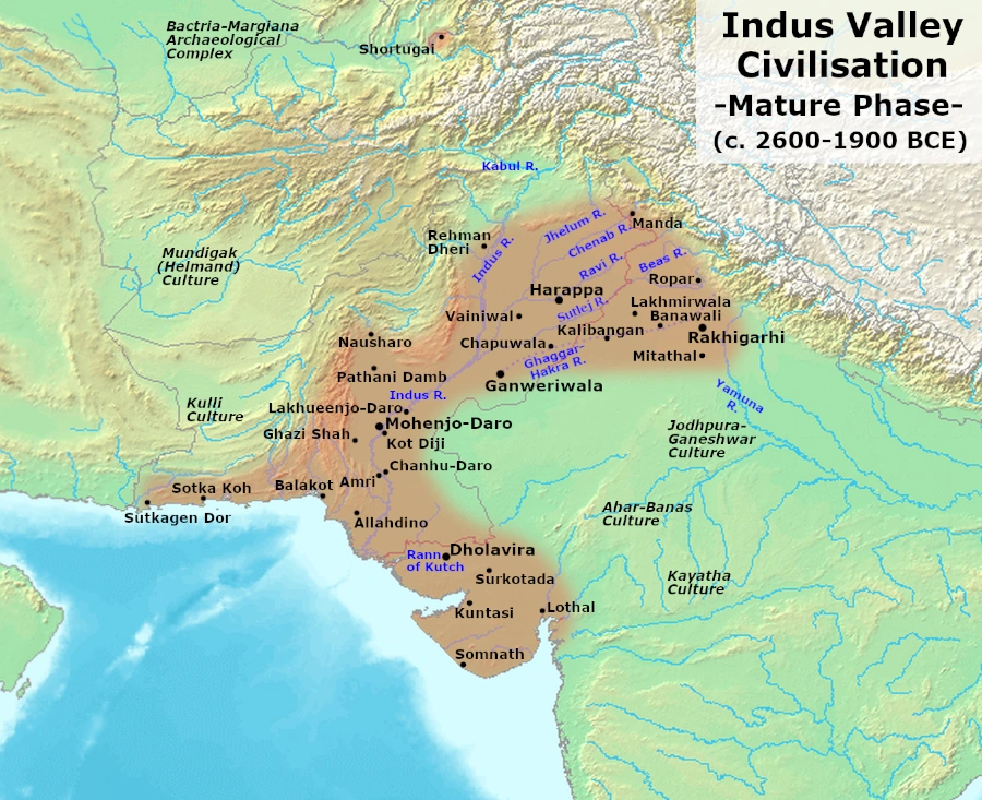
Map study
Mature Harappan civilisation, c. 2600–1900 BCE: settlement distribution, not the territory of a single empire.
- Read the source date and legend before interpreting territorial extent.
- Compare core regions, neighbouring powers and geographic barriers; historical borders and influence are approximate and changed over time.
Credit: Avantiputra7 · CC BY-SA 3.0 · sourceConverted to WebP on an opaque white background; proportionally resized without cropping. Original cartography and legend retained.
1. Location, discovery and chronological setting
Kalibangan stands in the Ghaggar plain of northwestern Rajasthan, a landscape now much drier than the settings usually associated with early agricultural settlements. Its location connects it with the wider Ghaggar-Hakra concentration of Harappan sites extending across northwestern India and adjoining Pakistan. Archaeological literature sometimes describes this as the Sarasvati region. However, the identification of an ancient river by a literary name, the timing of river changes, and the water available to particular settlements are separate questions requiring archaeological and geological evidence.
The Italian scholar Luigi Pio Tessitori drew attention to archaeological remains around Kalibangan during his work in Rajasthan in the early twentieth century. His observations preceded the formal recognition of the Indus civilisation in the 1920s. Following Independence, surveys and systematic excavations established Kalibangan as a crucial site for understanding the civilisation within India. The Archaeological Survey of India excavated it over nine field seasons between 1960 and 1969.
Two principal cultural phases were identified. The earlier settlement, called Kalibangan I, belongs to the Early Harappan stage; the later settlement, Kalibangan II, belongs to the Mature Harappan stage. Broadly, these correspond to the third millennium BCE, with the mature phase situated within the wider Harappan chronology of approximately 2600–1900 BCE. Exact local phase boundaries differ between chronological reconstructions and should not be treated as identical to civilisation-wide dates.
Timeline
Early third millennium BCE, broadly
Early Harappan Kalibangan I developed, with mud-brick fortification and the associated ploughed field.
Around the transition to Mature Harappan urbanism
Disturbances ending the earlier occupation were interpreted by excavators as possible earthquake damage.
Within approximately 2600–1900 BCE
Mature Harappan Kalibangan II developed its citadel, lower town and distinctive fire installations.
Early twentieth century
Luigi Pio Tessitori recognised the archaeological importance of remains in the locality.
1960–1969
The Archaeological Survey of India undertook major excavations under B. B. Lal and B. K. Thapar.
2. Settlement planning and the built environment
The Early Harappan settlement was already fortified with mud-brick walls. Its houses, lanes and craft remains demonstrate that organised settlement life preceded the mature urban phase. This is important because Harappan urbanism did not appear suddenly: it developed through regional agricultural communities, exchange networks and growing experience in construction and settlement organisation.
During the Mature Harappan period, Kalibangan had a fortified western citadel and a larger lower town to its east, which was also enclosed. The citadel was internally divided, with substantial platforms and installations in its southern sector. Streets in the lower town intersected broadly at right angles, and houses commonly opened onto subsidiary lanes. These features indicate planned circulation and control over building alignments, though they do not by themselves reveal the precise political authority responsible.
Mud brick was the main building material, while baked bricks were used selectively, including in certain water-related installations. Domestic wastewater could be managed through arrangements such as soakage jars and local drains. Kalibangan therefore should not be imagined as possessing the same extensive covered drainage system familiar from descriptions of Mohenjo-daro. Its planning reflects shared Harappan principles adapted to local requirements and resources.
For comparison-based questions, distinguish a citadel from a securely identified palace or temple. A raised, enclosed sector indicates spatial differentiation, but its name is an archaeological convention rather than proof of military rule. Likewise, planning and standardised construction imply coordination without establishing a particular monarchy, priesthood or republican institution.
How to evaluate an archaeological claim
- 1. Identify the excavated feature and its location.
- 2. Establish its cultural phase through stratigraphy and associated material.
- 3. Separate physical observations from proposed functions.
- 4. Compare with evidence from other sites and relevant scientific studies.
- 5. State the conclusion with appropriate limits and uncertainty.
3. The ploughed field and agricultural economy
Kalibangan’s most celebrated discovery is a field preserving intersecting furrows, found southeast of the Early Harappan settlement. The field is associated with the earlier occupation, not simply with the later mature town. It provides unusually direct archaeological evidence of cultivation techniques, whereas agriculture at many other sites is reconstructed primarily from seeds, tools and animal remains.
The furrows formed two sets crossing approximately at right angles. One set was spaced roughly 1.9 metres apart and the other about 30 centimetres apart. This arrangement has been compared with local mixed-cropping practices involving mustard and gram. That comparison suggests a possible agricultural strategy, but it does not establish beyond doubt which crops occupied each ancient furrow. The secure observation is the patterned field surface; the particular crop combination remains an interpretation.
The discovery suggests knowledge of field preparation and potentially efficient use of land through intercropping. It should be described as one of the earliest archaeologically attested ploughed fields, rather than proof that the plough was invented at Kalibangan. Cattle husbandry would have supported the wider agricultural economy through traction and other uses, while settlement life also depended on pottery production, crafts and exchange.
Riverine and seasonal water availability must have influenced cultivation in the Ghaggar plain. Nevertheless, a location beside a former river channel is not evidence for a large canal-irrigation system. Distinguishing excavated infrastructure from reasonable ecological inference is essential when assessing claims about Harappan farming.
| Evidence | What it supports | What it does not prove |
|---|---|---|
| Intersecting field furrows | Early Harappan plough cultivation | Invention of the plough at Kalibangan |
| Repeated fire installations | Activities involving controlled burning, plausibly ritual | Conclusive identification of Vedic sacrifice |
| Fortified sectors and planned streets | Coordinated settlement organisation | A specific form of government |
| Graves without surviving skeletons | Variation in funerary treatment; possible symbolic burial | Automatic proof of cremation |
| Structural disturbances | A proposed earthquake at an occupational transition | A civilisation-wide earthquake collapse |
4. Fire installations, pottery and burial practices
Kalibangan yielded installations conventionally interpreted as fire altars, including a row of seven on a platform in the citadel area. Related features were also identified in residential contexts. Some consisted of clay-lined pits with a central projection or upright element and evidence of burning. Their repeated form and arrangement encouraged a ritual interpretation, making them a distinctive feature of the site.
The term fire altar nevertheless contains an interpretation of function. These remains cannot, on their own, demonstrate Vedic sacrifice, identify a named deity, or establish the language or ethnic identity of the inhabitants. The Harappan script remains undeciphered, so precise claims about religious doctrine are especially uncertain. A sound answer separates the material evidence of fire installations from broader arguments about religious continuity.
Early Harappan pottery at Kalibangan is traditionally classified into six fabrics, labelled A to F, according to characteristics such as texture, surface treatment and decoration. Painted vessels include geometric and naturalistic designs. The mature occupation also produced recognisably Harappan material, including seals, beads, bangles and other craft objects. Such finds reveal both regional traditions and participation in a wider cultural and exchange system.
The cemetery southwest of the citadel contained several forms of burial. These included extended inhumations in rectangular pits, circular or oval pits containing pottery, and rectangular graves furnished with objects but without surviving human skeletons. The latter are often interpreted as symbolic burials. These variations caution against assuming a single Harappan funerary custom; graves lacking bodies do not automatically demonstrate cremation.
5. Environmental change and historical significance
Structural disturbances at the end of the Early Harappan phase have been interpreted by excavators as evidence of an earthquake. This is an important proposal, but it concerns a particular occupational transition and should not be presented as a proven explanation for the decline of the entire civilisation. A later Mature Harappan settlement developed at the site, demonstrating that the earlier disruption was not Kalibangan’s final abandonment.
The eventual abandonment of the mature town has often been connected with reduced water availability and changes in the Ghaggar system. Modern studies of northwestern Indian palaeochannels reveal a complex history involving ancient river courses, monsoon variability and changing local environments. They do not justify a simple claim that one great perennial river suddenly disappeared and simultaneously ended every Harappan settlement.
Kalibangan’s larger significance is threefold: it documents local development before mature urbanism, provides rare evidence of agricultural practice, and demonstrates diversity in settlement organisation and ritual behaviour. For Prelims, connect the site with Rajasthan, the Ghaggar, the Early Harappan ploughed field and fire installations. For analytical answers, use it to show how a shared Harappan cultural system accommodated regional variation.
Real-world case studies
The furrowed field: direct evidence and analogy
The intersecting furrows at Kalibangan are direct evidence of an ancient cultivation pattern. Comparison with regional mustard-and-gram cultivation helps explain how such spacing might have worked. The case illustrates a standard archaeological method: modern analogy can generate a plausible interpretation, but cannot independently establish the ancient crop combination.
Kalibangan and Mohenjo-daro: diversity within urbanism
Kalibangan’s extensive use of mud brick and relatively localised wastewater arrangements contrast with Mohenjo-daro’s celebrated baked-brick drains. Both belong to the Harappan urban tradition. Their comparison demonstrates that shared planning practices did not require identical materials, infrastructure or settlement scale.
Previous year questions
No source-linked PYQ is available here yet. Use the practice questions below.
Practice questions
Practice MCQ 1
With reference to Kalibangan, consider the following statements: 1. It is situated in present-day Rajasthan near the Ghaggar channel. 2. Its excavated ploughed field is associated with the Early Harappan occupation. 3. It is known for a basin conventionally interpreted as a dockyard. Which of the statements given above are correct?
- A. 1 and 2 only
- B. 2 and 3 only
- C. 1 and 3 only
- D. 1, 2 and 3
Practice MCQ 2
Which inference is best supported by the structures conventionally called fire altars at Kalibangan?
- A. The inhabitants certainly spoke Vedic Sanskrit.
- B. The site contains repeated installations involving fire, some plausibly used for ritual purposes.
- C. All Harappan settlements followed an identical religious system.
- D. The Harappan script has been deciphered as ritual literature.
Practice MCQ 3
Consider the following pairs concerning Kalibangan: 1. Kalibangan I — Early Harappan occupation 2. Principal building material — Mud brick 3. Cemetery evidence — Only one uniform form of burial How many of the pairs given above are correctly matched?
- A. Only one
- B. Only two
- C. All three
- D. None
Mains practice · Kalibangan demonstrates both the shared characteristics and the regional diversity of Harappan civilisation. Discuss with reference to its agricultural, urban and ritual evidence. Answer in 150 words.
- Locate Kalibangan in Rajasthan’s Ghaggar plain and distinguish its Early and Mature Harappan phases.
- Explain the importance of the Early Harappan ploughed field without treating the inferred crop combination as certain.
- Identify shared features such as planned streets, fortifications and Harappan material culture.
- Discuss local characteristics, including predominant mud-brick construction and wastewater arrangements.
- Mention fire installations and varied burials while separating evidence from religious interpretation.
- Conclude that cultural integration coexisted with regional adaptation.
Further reading
- NCERT, Themes in Indian History, Part I, Chapter 1: Bricks, Beads and Bones.
- Archaeological Survey of India, Excavations at Kalibangan: The Early Harappans (1960–1969), Memoirs of the Archaeological Survey of India No. 98.
- Archaeological Survey of India, Indian Archaeology: A Review, excavation reports for the Kalibangan field seasons.
- Upinder Singh, A History of Ancient and Early Medieval India: From the Stone Age to the 12th Century.
- Archaeological Survey of India official website: information on Kalibangan and its archaeological museum.
Preparing for UPSC Civil Services? Get classroom teaching, answer-writing evaluation and mentorship at Pragnya IAS Academy, Ashok Nagar — see why aspirants choose us for IAS coaching in Hyderabad.