
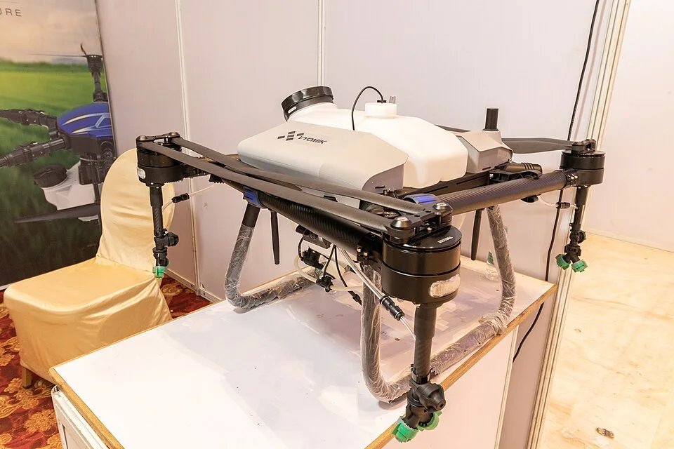
UAV display by Vyomik Drones at the Amaravati Drone Summit, according to the supplied metadata.
Credit: iMahesh · CC BY-SA 4.0 · sourceResized and converted to WebP; uncropped.
1. Meaning, types and enabling technologies
A drone, commonly called an unmanned aerial vehicle, is an aircraft without an onboard pilot. The broader term unmanned aircraft system includes the aircraft, control station, communication links and supporting components. Remotely piloted aircraft are a subset in which a remote pilot manages flight. Autonomous systems execute some or all flight functions through software. A drone need not use artificial intelligence: many simply follow programmed waypoints under human supervision.
Multirotor drones generate lift using several powered rotors. Quadcopters are common because they can take off vertically, hover and manoeuvre in confined spaces. These characteristics suit inspection and photography, but continuous powered lift limits endurance. Fixed-wing drones generate lift through forward motion over wings, generally offering greater range and endurance. They cannot ordinarily hover and may need a runway, launcher or recovery system. Hybrid vertical take-off and landing designs combine vertical launch with efficient wing-borne flight.
Core components include a frame, propulsion system, battery or engine, flight controller, sensors, navigation equipment, communication links and mission payload. The flight controller processes measurements and adjusts motors or control surfaces to stabilise the aircraft. Useful payloads include cameras, sprayers, delivery containers and scientific instruments. Payload capacity must be balanced against endurance: carrying more weight usually increases energy consumption.
- Inertial measurement units use accelerometers and gyroscopes to estimate motion and orientation.
- Global navigation satellite systems, including GPS and NavIC, can provide positioning where compatible receivers and adequate signals are available.
- A remotely piloted drone is not necessarily autonomous, and an autonomous drone is not necessarily AI-enabled.
Timeline
April 2020
SVAMITVA was launched as a pilot programme using drone surveys for mapping inhabited rural areas.
August 2021
Drone Rules, 2021 established a liberalised civilian regulatory framework.
September 2021
The production-linked incentive scheme for drones and drone components was approved.
February 2022
Amended rules introduced remote pilot certificate terminology; DGFT revised drone import policy.
November 2023
The Union Cabinet approved the scheme subsequently known as Namo Drone Didi.
2. Navigation, sensing and communication
Satellite positioning supports waypoint navigation, geotagging and return-to-home functions. However, buildings, terrain, interference and deliberate spoofing can degrade or falsify positioning signals. Inertial navigation helps bridge interruptions but accumulates error over time. Sensor fusion combines different measurements to improve estimates. Real-time kinematic positioning uses correction data from a reference station or network and can achieve centimetre-level positioning under suitable conditions; this is not the default accuracy of every drone.
Different sensors answer different questions. Ordinary cameras record visible light, while photogrammetry reconstructs terrain or structures from overlapping images. Multispectral cameras measure selected wavelength bands and support vegetation indices such as the normalised difference vegetation index, which uses red and near-infrared reflectance. Thermal cameras detect infrared radiation associated with temperature differences. LiDAR measures distance using laser pulses and can create detailed three-dimensional point clouds. None of these instruments automatically guarantees an accurate interpretation without calibration and ground verification.
The command-and-control link carries instructions and aircraft status information. Payload data, such as video, may use a separate link. Beyond visual line of sight operations extend beyond the pilot’s direct visual observation and require stronger arrangements for communications, airspace coordination and collision avoidance. They are not automatically permitted merely because a drone has sufficient technical range. Geofencing creates software-defined operating boundaries, but cannot substitute for legal compliance or reliable navigation.
- Visual line of sight refers to direct visual observation sufficient to manage flight safely, not merely watching a camera feed.
- A drone swarm involves coordinated operation of multiple drones; simply launching several independent drones does not establish intelligent swarm behaviour.
Drone-based mapping workflow
- 1. Define the survey objective and required accuracy.
- 2. Check airspace, applicable permissions and site safety.
- 3. Plan flight paths, image overlap and ground control.
- 4. Collect geotagged imagery or other sensor measurements.
- 5. Process data into orthomosaics, elevation models or point clouds.
- 6. Validate accuracy through ground checks and deliver usable maps.
3. Civilian and strategic applications
In agriculture, drones support crop monitoring, pest identification, irrigation assessment and targeted application of inputs. Precision spraying can reduce workers’ direct exposure to chemicals and improve access to difficult fields. Benefits depend on appropriate nozzles, droplet size, weather, flight height and crop conditions. Wind-driven drift can damage neighbouring crops or expose people and pollinators. Aviation permission does not replace applicable pesticide requirements or agricultural safety protocols.
Surveying drones collect high-resolution imagery for cadastral mapping, road alignment, mine measurement and construction monitoring. In disasters they help assess flood extent, locate stranded people, map landslides and inspect damaged infrastructure without immediately exposing field teams. Medical delivery can improve last-mile access across hills or rivers, although payload limits, temperature control, reliable landing sites and adverse weather constrain operations. Environmental uses include wildlife surveys, forest monitoring and assessment of coastal erosion.
Strategic applications include reconnaissance, surveillance, target acquisition, logistics and armed missions. Small drones may provide inexpensive situational awareness, while larger platforms offer longer endurance and heavier payloads. Loitering munitions combine extended airborne search with an attack function and should not be treated as ordinary reusable camera drones. Counter-drone systems combine detection, identification, tracking and interception; detection alone does not neutralise a threat.
- SVAMITVA uses drone surveying to support mapping of inhabited rural areas and preparation of property records.
- ICMR’s i-Drone initiative demonstrated medical-supply delivery by drones in the Northeast.
- The Namo Drone Didi scheme supports provision of drones to selected women’s self-help groups for agricultural rental services.
| Category | Weight |
|---|---|
| Nano | Up to and including 250 grams |
| Micro | More than 250 grams and up to 2 kilograms |
| Small | More than 2 kilograms and up to 25 kilograms |
| Medium | More than 25 kilograms and up to 150 kilograms |
| Large | More than 150 kilograms |
4. India’s regulatory framework and industrial policy
The Drone Rules, 2021, notified on 25 August 2021, replaced the more restrictive Unmanned Aircraft System Rules issued earlier that year. The framework addresses certification, registration, remote pilots and airspace operations. The Directorate General of Civil Aviation is the principal civil aviation regulator, while the Ministry of Civil Aviation frames policy. These rules do not apply to UAS belonging to or used by the naval, military or air forces of the Union.
The Digital Sky airspace map distinguishes green, yellow and red zones. In a green zone, prior permission for flight is generally not required within the prescribed limits. Green airspace normally extends up to 400 feet, or 120 metres, where not designated yellow or red; in the belt between 8 and 12 kilometres from an operational airport’s perimeter, the green limit is 200 feet, or 60 metres. Yellow-zone operations require permission from the concerned air traffic control authority, while red-zone operations require Central Government permission. Operators must check the current map because restrictions can change.
Type certification, registration and remote pilot certification serve different purposes. Type certification concerns conformity of a drone design, registration identifies an individual aircraft, and pilot certification concerns operator competency. Nano drones and model remotely piloted aircraft systems receive specified exemptions; these are not blanket permissions to fly anywhere. A remote pilot certificate is not required for nano drones or for micro drones used for non-commercial purposes. The Drone (Amendment) Rules, 2022 replaced the terminology of remote pilot licence with remote pilot certificate.
Industrial policy combines domestic manufacturing incentives with import controls. The production-linked incentive scheme for drones and drone components was approved in 2021 with an outlay of ₹120 crore over three financial years. In February 2022, import policy prohibited drones in completely built-up, semi-knocked-down and completely knocked-down forms, subject to specified exceptions, while drone-component imports remained free. Import controls should therefore not be confused with a total ban on importing every drone-related item.
- Before operation, verify the applicable aircraft, pilot, airspace and activity-specific requirements separately.
- Airspace permission does not override privacy, property, environmental or security obligations.
5. Risks, governance and examination relevance
Safety risks include collisions with aircraft, falling components, battery fires and loss of control. Small drones can be difficult to detect because they fly low and have a limited radar signature. Cybersecurity threats include compromised software, hijacked control links, navigation spoofing and unauthorised access to imagery. Encryption, authentication, secure updates, maintenance and tested lost-link procedures reduce risk but cannot eliminate it.
Persistent aerial observation can reveal personal movements, household activities and sensitive infrastructure. Responsible deployment requires lawful data collection, purpose limitation, proportionate retention and access controls. Environmental concerns include wildlife disturbance, noise and battery waste. Economic limitations include imported components, uneven repair networks, shortages of trained personnel and uncertain commercial viability in low-demand locations.
A balanced governance approach enables useful applications while differentiating risks by aircraft weight, location, payload and operating method. Shared service models can make drones accessible to small farmers without requiring individual ownership. Regulatory sandboxes and controlled trials can generate evidence for more complex operations. For Prelims, focus on technology-function matching, weight categories, airspace distinctions and conditional exemptions rather than assuming that every drone is autonomous, satellite-dependent or legally unrestricted.
- Counter-drone methods include radar, radio-frequency sensing, optical and acoustic detection, followed by authorised electronic or physical interception.
- Jamming can disrupt legitimate communications and navigation; it is not a routine countermeasure available to private drone operators.
Drones: From Aerial Platforms to Operational Systems
The metadata identifies a UAV displayed at the Amaravati Drone Summit, making this a directly relevant Indian illustration of drone technology. A drone is only the airborne component of a broader unmanned aircraft system, which also includes control facilities, communication links and supporting equipment. Its usefulness depends on the combination of flight platform and payload: cameras support mapping, thermal sensors aid searches, and spraying equipment enables agricultural applications. The metadata does not establish this aircraft’s configuration, payload, endurance or degree of autonomy; these capabilities should not be inferred from its presence at a technology exhibition.
In India, drones can support agricultural monitoring, village property surveys, infrastructure inspection and disaster assessment. However, collecting aerial imagery is not equivalent to producing reliable decisions: mapping requires accurate positioning, suitable resolution, ground verification and careful interpretation. Operations also face battery, weather, communication and airspace constraints. The Drone Rules, 2021, as amended, provide the principal civilian framework, while permissions and operating conditions depend on the applicable requirements. For governance analysis, distinguish aviation safety from data protection: an operationally permitted flight can still raise concerns about surveillance, consent and sensitive information.
- Remote control, programmed flight and autonomy are distinct; following preset waypoints does not by itself demonstrate artificial intelligence.
- Satellite navigation supports positioning, but reliable flight also depends on onboard sensors, control algorithms and contingency procedures.
- Evaluate applications by payload, accuracy, endurance and operating risk; exhibition metadata cannot verify performance claims or regulatory compliance.
Real-world case studies
SVAMITVA: technology within a land-record process
The Ministry of Panchayati Raj’s SVAMITVA scheme combines Survey of India drone mapping with state-level verification and property-record procedures in inhabited rural areas. Its importance lies in linking precise spatial data to administrative records. Aerial imagery alone cannot determine lawful ownership: ground verification, dispute resolution and applicable state procedures remain essential.
ICMR i-Drone in Manipur
In October 2021, ICMR demonstrated vaccine delivery by drone from Bishnupur district hospital to Karang island in Manipur’s Loktak Lake. The demonstration illustrated how aerial logistics can bypass circuitous surface routes. Scaling such services requires validated cold chains, reliable communications, trained personnel and integration with public-health facilities.
Previous year questions
UPSC Prelims 2020
Consider the following activities: 1. Spraying pesticides on a crop field. 2. Inspecting the craters of active volcanoes. 3. Collecting breath samples from spouting whales for DNA analysis. At the present level of technology, which of these can be successfully carried out using drones?
- A. 1 and 2 only
- B. 2 and 3 only
- C. 1 and 3 only
- D. 1, 2 and 3
Practice questions
Practice MCQ 1
With reference to drone payloads, consider the following pairs: 1. LiDAR: laser-based distance measurement. 2. Thermal camera: detection of temperature-related infrared radiation. 3. Multispectral camera: measurement restricted to a single visible-light wavelength. Which pairs are correctly matched?
- A. 1 and 2 only
- B. 2 and 3 only
- C. 1 and 3 only
- D. 1, 2 and 3
Practice MCQ 2
Under India’s Drone Rules, 2021, a drone with a maximum all-up weight of exactly 2 kilograms, including payload, falls in which category?
- A. Nano
- B. Micro
- C. Small
- D. Medium
Practice MCQ 3
Consider the following statements: 1. Every waypoint-following drone necessarily uses artificial intelligence. 2. Fixed-wing drones generally offer greater endurance than comparable multirotor drones. 3. Green-zone status removes all legal requirements applicable to drone operations. Which statements are correct?
- A. 1 only
- B. 2 only
- C. 1 and 3 only
- D. 2 and 3 only
Mains practice · Drones can improve public-service delivery, but technological capability alone does not ensure public value. Discuss with reference to agriculture, land records and healthcare in India. Suggest safeguards for responsible deployment. Answer in 250 words.
- Explain precision sensing, mapping and last-mile delivery capabilities.
- Use Namo Drone Didi, SVAMITVA and ICMR i-Drone as examples.
- Distinguish aerial mapping from legal determination of land ownership.
- Assess affordability, weather, repair capacity, connectivity and cold-chain constraints.
- Address pesticide drift, privacy, cybersecurity and airspace safety.
- Recommend shared services, ground validation, trained personnel, outcome evaluation and risk-based regulation.
Further reading
- Ministry of Civil Aviation: Drone Rules, 2021 and subsequent amendments.
- DGCA Digital Sky: airspace map, drone categories and regulatory guidance.
- Directorate General of Foreign Trade: Notification No. 54/2015-2020, dated 9 February 2022.
- Ministry of Panchayati Raj: SVAMITVA framework and implementation guidelines.
- Indian Council of Medical Research: i-Drone initiative and guidance on drone-based healthcare delivery.
- Department of Agriculture and Farmers Welfare: Namo Drone Didi operational guidelines.
- https://commons.wikimedia.org/wiki/File:An_UAV_displayed_by_Vyomik_drones_at_Amaravati_Drone_summit_(02).jpg
Preparing for UPSC Civil Services? Get classroom teaching, answer-writing evaluation and mentorship at Pragnya IAS Academy, Ashok Nagar — see why aspirants choose us for IAS coaching in Hyderabad.