
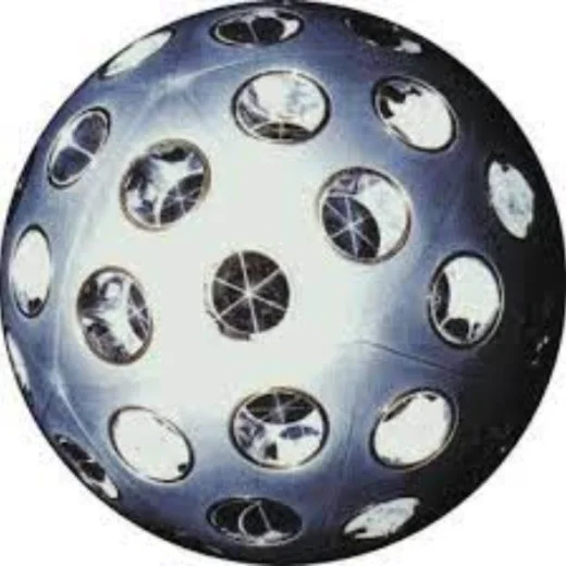
Starlette, a French passive satellite used for satellite laser ranging and geodetic research.
Credit: eoPortal.org · Public domain · sourceResized and converted to WebP; uncropped.
1. Satellite fundamentals and spacecraft architecture
An artificial satellite is placed on a trajectory where gravity provides the centripetal acceleration required for orbital motion. Its forward velocity prevents it from simply falling to the surface. Astronauts and objects aboard an orbiting spacecraft experience apparent weightlessness because they fall together. Gravity remains substantial even at the altitude of the International Space Station.
A satellite has two broad components: the payload, which performs the mission, and the spacecraft bus, which supports it. Payloads include cameras, radar instruments, communication transponders, atomic clocks and scientific detectors. The bus provides structural support, electrical power, thermal control, onboard computing, attitude control and, where required, propulsion.
Solar arrays commonly generate electricity, while batteries support operations during eclipse. Attitude control points antennas or instruments correctly using devices such as reaction wheels and thrusters. Telemetry reports spacecraft health; tracking determines its position; telecommand carries instructions from Earth. Propulsion may support orbit raising, station-keeping, collision avoidance and disposal.
A launch vehicle carries a spacecraft into space but is not the satellite itself. Similarly, an orbit is a trajectory rather than a geographical boundary. Satellite mass classifications such as small satellite and microsatellite vary between organisations; CubeSats instead follow a standardised modular form factor.
2. Orbits and their application-based selection
Low Earth orbit, conventionally extending to about 2,000 km altitude, is widely used for imaging, scientific missions and broadband constellations. Proximity permits detailed observation and relatively low communication latency. However, a satellite moves rapidly across the sky, so continuous communication usually requires multiple satellites and handovers. Residual atmospheric drag can shorten orbital life.
Medium Earth orbit lies between low Earth orbit and geostationary altitude. Several global navigation systems use MEO because it balances coverage, constellation size and signal geometry. Higher altitude generally increases coverage per satellite but also increases signal travel time and weakens received signals.
A geosynchronous orbit has a period equal to Earth’s sidereal rotation period, approximately 23 hours 56 minutes. A geostationary orbit is its special circular, equatorial case, moving in the same direction as Earth’s rotation. It appears fixed over one longitude, enabling stationary ground antennas. Coverage is poor at high latitudes, and polar regions are not visible.
Polar or near-polar satellites pass over or close to the poles, allowing successive ground tracks to sample different longitudes as Earth rotates. A Sun-synchronous orbit has a precessing orbital plane that maintains approximately the same local solar time for repeated observations. This supports comparable illumination for mapping and change detection. Not every polar orbit is Sun-synchronous, and Sun-synchronous does not mean continuous sunlight.
From satellite observation to public decision
- 1. A sensor records electromagnetic signals
- 2. Data are transmitted to a ground station
- 3. Measurements undergo calibration and correction
- 4. Analysts integrate imagery with ground information
- 5. Authorities use validated products for decisions
3. Major applications and operating principles
Communication satellites relay signals for broadcasting, telephony, broadband and emergency connectivity. A conventional transponder receives an uplink signal, amplifies it, changes its frequency and retransmits it through a downlink. Frequency-band choice involves trade-offs among bandwidth, antenna size and atmospheric attenuation. Higher-frequency links, especially in Ku and Ka bands, can suffer rain attenuation.
Earth-observation satellites measure reflected or emitted electromagnetic radiation. Passive optical sensors depend on sunlight for reflected-light imaging and are often obstructed by clouds. Thermal infrared sensors measure emitted radiation and can operate at night, although clouds remain a constraint. Active radar supplies its own illumination; synthetic aperture radar enables day-and-night observation and can generally image through cloud cover.
Navigation satellites broadcast precise timing and orbital information. Receivers estimate signal travel times and calculate position through ranging. Normally, at least four satellites are required to solve three-dimensional position and receiver-clock error. Navigation satellites do not ordinarily track users merely because users receive their signals.
Meteorological satellites monitor clouds, cyclones, atmospheric moisture and other variables. Geostationary platforms provide frequent regional observations, while polar-orbiting platforms provide global coverage and complementary measurements. Scientific satellites observe phenomena such as ultraviolet and X-ray radiation that Earth’s atmosphere blocks from reaching ground-based instruments.
- Spatial resolution: the ground detail represented by an observation.
- Spectral resolution: the ability to distinguish wavelength intervals.
- Temporal resolution: how frequently a location is observed.
- Radiometric resolution: the ability to distinguish small differences in measured energy.
| Orbit | Defining feature | Typical application |
|---|---|---|
| Low Earth orbit | Relatively close to Earth; short orbital period | Imaging, research, broadband constellations |
| Medium Earth orbit | Between LEO and geostationary altitude | Many global navigation constellations |
| Geostationary orbit | Circular, equatorial and Earth-synchronous | Broadcasting and continuous regional weather monitoring |
| Sun-synchronous orbit | Approximately constant local solar time at repeat passes | Mapping and environmental change detection |
4. India’s important satellite systems
ISRO’s INSAT and GSAT systems support communication and broadcasting; INSAT meteorological missions also support weather observation. INSAT-3DS, launched by GSLV-F14 in February 2024, is a meteorological satellite intended to improve weather monitoring, forecasting and disaster warning.
India’s Earth-observation programme includes the IRS heritage and missions such as Resourcesat, Cartosat, Oceansat and radar-imaging satellites. Their observations support crop assessment, land-use mapping, water-resource management, ocean studies and disaster response. Mission names indicate broad roles, but individual satellites differ in sensors and capabilities. ISRO’s Bhuvan platform and the National Remote Sensing Centre support access to geospatial products and services.
NavIC, formerly called the Indian Regional Navigation Satellite System, provides positioning, navigation and timing services over India and a region extending about 1,500 km beyond its boundary. Its original architecture comprises seven satellites: three geostationary and four inclined geosynchronous. This design should not be confused with the number of operational satellites at any particular time. Services include a Standard Positioning Service and a restricted service for authorised users.
GAGAN, jointly developed by ISRO and the Airports Authority of India, is a satellite-based augmentation system that improves navigation accuracy and integrity, particularly for civil aviation; it is not an independent navigation constellation. AstroSat, launched in September 2015, is India’s first dedicated multi-wavelength space observatory. The Indian Space Policy 2023 provides for greater non-government participation, with IN-SPACe facilitating and authorising such activities.
5. Limitations, sustainability and strategic significance
Satellites support governance through agricultural monitoring, cyclone warning, fisheries advisories, infrastructure planning and border surveillance. Yet satellite observations require calibration, ground verification and careful interpretation. A sensor records physical signals; it does not automatically establish land ownership, crop loss or the cause of environmental change.
Space debris includes defunct satellites, spent rocket stages and fragments. At orbital speeds, even small objects can cause severe damage. Repeated collisions may generate a self-reinforcing debris cascade, commonly associated with the Kessler syndrome. Mitigation includes collision avoidance, post-mission disposal and passivation, which removes stored energy that could cause explosions.
Low-orbit satellites may be deorbited for atmospheric re-entry, while geostationary spacecraft are commonly moved to disposal orbits above the operational belt. Other risks include space weather, radio-frequency interference, cyberattacks and disruption of ground infrastructure. Sustainable satellite use therefore combines engineering reliability, international coordination, responsible disposal and resilient ground systems.
Passive satellites: measuring Earth through precise orbits
Starlette illustrates a specialised satellite application: geodesy, the science of measuring Earth’s shape, gravity field and orientation. Unlike a communications satellite that receives and retransmits signals, this passive satellite carries retroreflectors that return incident laser light towards its source. Ground stations measure the round-trip travel time of laser pulses to estimate distance. Repeated observations help determine the satellite’s orbit precisely; departures from a simplified orbital model provide information about Earth’s gravitational field and other forces acting on the satellite.
For India, the conceptual lesson is that a satellite’s usefulness depends on its payload and measurement system, not simply its size or ability to transmit data. Indian communication, Earth-observation and navigation systems perform different functions and should not be treated as interchangeable. Starlette is a French comparative example, not evidence of an Indian mission or capability. The supplied metadata identifies the satellite but does not establish details of the pictured configuration. Laser-ranging results also require atmospheric corrections, accurate timing and orbital modelling; a measured distance alone does not directly reveal Earth’s complete gravity field.
- Passive does not mean scientifically inactive: retroreflectors enable measurements without an onboard radio transmitter generating the ranging signal.
- Do not confuse satellite laser ranging with satellite navigation: ranging stations track a satellite, whereas navigation receivers use broadcast signals to determine position and time.
- Distinguish platform from launcher: the satellite performs the orbital mission; the launch vehicle places it on its intended trajectory.
Real-world case studies
Cyclone Phailin, 2013
Satellite observations contributed to monitoring Phailin over the Bay of Bengal. IMD forecasts, evacuation planning and coordination in Odisha helped limit casualties compared with the 1999 super cyclone. The lesson is that space-based information saves lives when connected to effective last-mile action.
Cartosat-2D rideshare launch, 2017
PSLV-C37 launched 104 satellites in February 2017, including Cartosat-2D and numerous small satellites. The mission demonstrated multi-satellite deployment capability and rideshare economics. The launch vehicle was PSLV; the deployed spacecraft were distinct satellites.
Previous year questions
No source-linked PYQ is available here yet. Use the practice questions below.
Practice questions
Practice MCQ 1
Which conditions are necessary for an Earth satellite to appear stationary to a ground observer?
- A. A circular polar orbit with a 24-hour period
- B. A circular equatorial prograde orbit with a sidereal-day period
- C. Any elliptical orbit with a sidereal-day period
- D. Any Sun-synchronous orbit
Practice MCQ 2
Consider the following statements: 1. Synthetic aperture radar supplies its own illumination. 2. Passive reflected-light imaging normally requires sunlight. 3. Sun-synchronous satellites necessarily remain in sunlight continuously. Which are correct?
- A. 1 and 2 only
- B. 2 and 3 only
- C. 1 and 3 only
- D. 1, 2 and 3
Practice MCQ 3
Which statement correctly distinguishes NavIC from GAGAN?
- A. Both are independent global navigation constellations.
- B. NavIC is an augmentation system, while GAGAN is an Earth-imaging mission.
- C. NavIC provides regional navigation, while GAGAN augments navigation accuracy and integrity.
- D. GAGAN operates without ground infrastructure.
Mains practice · Satellite technology is a developmental asset as well as a strategic infrastructure. Discuss with reference to India, highlighting the requirements for sustainable use. Answer in 250 words.
- Explain communication, navigation, Earth observation and weather applications.
- Use NavIC, INSAT, Cartosat and GAGAN as examples.
- Connect satellite information with disaster response and public-service delivery.
- Discuss debris, interference, cybersecurity and space-weather risks.
- Recommend disposal compliance, resilient ground systems and international coordination.
Further reading
- ISRO official website: satellite missions, satellite navigation and space applications.
- NCERT, Physics Part I, Class XI: Gravitation.
- Department of Space: Indian Space Policy 2023.
- National Remote Sensing Centre: Earth-observation applications and Bhuvan resources.
- Airports Authority of India: GAGAN.
- United Nations Office for Outer Space Affairs: Space Debris Mitigation Guidelines.
- https://commons.wikimedia.org/wiki/File:Starlette_Satellite.jpg
Preparing for UPSC Civil Services? Get classroom teaching, answer-writing evaluation and mentorship at Pragnya IAS Academy, Ashok Nagar — see why aspirants choose us for IAS coaching in Hyderabad.