
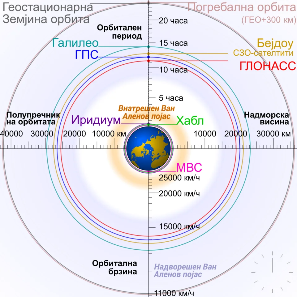
Comparative diagram of Earth-orbiting satellites and other bodies, with labels in Macedonian.
Credit: original by Cmgleederivative by B. Jankuloski · CC BY-SA 4.0 · sourceResized and converted to WebP; uncropped.
1. Orbital mechanics: the foundations
An orbit results from the balance between a body's forward motion and gravitational acceleration towards a larger body. A satellite does not require continuous engine thrust to remain in an ideal orbit. Its tangential velocity carries it forward while gravity continually bends its path. Astronauts experience apparent weightlessness because both they and their spacecraft are in free fall, not because Earth's gravitational field disappears at orbital altitude. Real satellites nevertheless require occasional manoeuvres to correct disturbances and maintain their assigned trajectories.
Kepler's first law states that a bound two-body orbit is an ellipse with the attracting body at one focus; a circle is a special case. The second law states that the line joining the bodies sweeps equal areas in equal times. Consequently, an Earth satellite moves fastest at perigee, its nearest point to Earth, and slowest at apogee, its farthest point. Under the third law, the square of the orbital period is proportional to the cube of the semi-major axis for bodies orbiting the same central mass.
In a circular Earth orbit, speed is given by v = √(GM/r), while period is T = 2π√(r³/GM). Here, r is distance from Earth's centre, not altitude above its surface. Higher circular orbits therefore have lower orbital speeds but longer periods. Orbital speed near Earth is roughly 7.8 km/s; escape speed near the surface is about 11.2 km/s when atmospheric resistance and Earth's rotation are neglected. Escape velocity is not the speed required to remain in a circular orbit.
- Eccentricity describes orbital shape: zero indicates a circle; values between zero and one indicate an ellipse.
- Inclination is the angle between the orbital plane and the reference plane, usually Earth's equatorial plane for Earth satellites.
- Prograde Earth orbits have inclinations below 90°; retrograde orbits have inclinations above 90°.
2. Altitude classes and their applications
Low Earth orbit, or LEO, generally covers altitudes up to about 2,000 km. Many operational satellites occupy the region from a few hundred kilometres upward, where atmospheric drag is manageable. Typical orbital periods are around 90–130 minutes. Shorter distance enables low communication latency and detailed Earth imaging with suitable sensors. However, each satellite has a relatively small coverage footprint and moves rapidly across the sky, so continuous global services usually require a constellation and supporting ground infrastructure.
Medium Earth orbit, or MEO, lies between LEO and geosynchronous altitude. It is particularly important for satellite navigation because it offers wider coverage than LEO while avoiding the greater distance of geostationary orbit. GPS satellites operate at roughly 20,200 km altitude with periods close to 12 hours; Galileo satellites operate at about 23,222 km. Navigation constellations use several orbital planes to provide enough simultaneously visible satellites for positioning, navigation and timing.
Highly elliptical orbits combine a low perigee with a distant apogee. Because satellites move slowly near apogee, a suitably oriented orbit provides prolonged coverage of a chosen region. Molniya-type orbits have periods of approximately 12 hours and inclinations near 63.4°, making them useful for high-latitude coverage. Geostationary satellites appear low above the horizon at high latitudes and offer poor polar coverage, which helps explain the value of elliptical alternatives.
- LEO applications include Earth observation, crewed space stations and broadband constellations.
- MEO is strongly associated with global navigation systems, but not all navigation satellites use MEO.
- Orbit selection balances coverage, resolution, latency, radiation exposure, launch energy and operational lifetime.
Conventional deployment into geostationary orbit
- 1. Launch vehicle injects the spacecraft into a geostationary transfer orbit.
- 2. Spacecraft travels towards the high-altitude apogee.
- 3. Propulsion manoeuvres raise perigee and correct inclination.
- 4. Spacecraft reaches a near-circular equatorial geosynchronous orbit.
- 5. Longitude acquisition and station-keeping maintain the assigned geostationary position.
3. Geosynchronous, geostationary, polar and Sun-synchronous orbits
A geosynchronous Earth orbit has an orbital period equal to Earth's sidereal rotation period. It may be inclined or elliptical, in which case its satellite changes position in the sky during the day. A geostationary orbit is the special circular, equatorial and prograde geosynchronous orbit. Its satellite appears fixed over one longitude, allowing a ground antenna to remain pointed in a constant direction. All geostationary orbits are geosynchronous, but not all geosynchronous orbits are geostationary.
Geostationary satellites operate at approximately 35,786 km altitude, corresponding to an orbital radius of about 42,164 km. They support telecommunications, broadcasting and repeated observation of weather systems over broad regions. Their limitations include greater signal delay than LEO, weak polar coverage and the need to coordinate orbital positions and radio frequencies. Geostationary satellites still require station-keeping because solar and lunar gravity, Earth's uneven gravitational field and solar radiation pressure disturb their motion.
A polar orbit has an inclination close to 90° and passes over or near both poles. As Earth rotates beneath it, successive passes observe different longitude belts. A Sun-synchronous orbit is usually near-polar and slightly retrograde. Its orbital plane precesses, chiefly because of Earth's equatorial bulge, at a rate that approximately tracks Earth's annual motion around the Sun. This maintains comparable lighting conditions for repeated imaging, supporting land-use mapping, crop monitoring and environmental analysis.
- Polar and Sun-synchronous are not synonyms: not every polar orbit is Sun-synchronous.
- Sun-synchronous does not mean that a satellite stays above one location or remains continuously illuminated.
- Revisit time depends on altitude, sensor swath, orbital geometry and constellation size, not orbital period alone.
| Category | Defining feature | Typical application or example |
|---|---|---|
| LEO | Generally up to about 2,000 km altitude | Space stations and Earth observation |
| MEO | Between LEO and geosynchronous altitude | GPS and Galileo navigation |
| Geostationary | Circular, equatorial, prograde; one sidereal-day period | INSAT communication and weather services |
| Sun-synchronous | Orbital-plane precession preserves local solar crossing time | Resourcesat land monitoring |
| Highly elliptical | Long residence time near apogee | Molniya-type high-latitude coverage |
4. Transfer orbits, escape trajectories and Lagrange regions
A transfer orbit connects two operational orbits. A conventional geostationary transfer orbit, or GTO, is elliptical, with apogee near geostationary altitude and a much lower perigee. Following launch, onboard propulsion raises perigee, reduces inclination where necessary and establishes the final orbit. GTO is therefore an intermediate trajectory, not another name for geostationary orbit. Electric propulsion can also raise orbits gradually through repeated low-thrust operation.
Lagrange points are locations in the rotating frame of a two-body system where gravitational and centrifugal effects allow a small body to maintain a particular relative configuration. There are five such points. Missions often follow halo or Lissajous trajectories around these regions rather than sitting exactly at a point. Sun–Earth L1 supports solar observation, while the L2 region is useful for astronomical observatories. L1 and L2 are dynamically unstable and require station-keeping.
- Aditya-L1 operates in a halo orbit around Sun–Earth L1, approximately 1.5 million km from Earth towards the Sun.
- The James Webb Space Telescope follows a halo orbit around Sun–Earth L2.
- An interplanetary transfer is distinct from a closed Earth orbit; mission design must account for the Sun's gravitational influence.
5. Indian applications and orbital sustainability
India's missions illustrate why orbital classifications must be linked to purpose. INSAT and GSAT satellites commonly use geostationary positions for communication and meteorology. Many Resourcesat and Cartosat missions use Sun-synchronous orbits for Earth observation. NavIC's original seven-satellite architecture combined three geostationary satellites and four inclined geosynchronous satellites. It therefore provides a useful counterexample to the assumption that every navigation system operates in MEO.
Orbital debris includes defunct spacecraft, spent rocket stages and fragmentation products. High relative velocities can make even small objects destructive. Collision cascades, commonly associated with the Kessler syndrome, could render heavily used orbital regions increasingly hazardous. Mitigation includes limiting debris release, passivating stored energy sources, tracking objects, conducting collision-avoidance manoeuvres and planning end-of-life disposal. Atmospheric re-entry is commonly used for suitable LEO missions; geostationary spacecraft are generally moved to disposal orbits above the operational belt.
- ISRO's Project NETRA strengthens space situational awareness and protection of Indian space assets.
- ISRO has announced an objective of debris-free space missions by 2030 for Indian space actors; this does not mean removing all existing orbital debris.
- Atmospheric drag varies with solar activity, influencing LEO orbital decay and re-entry predictions.
Orbital Parameters and Their Applications
The metadata identifies this image as a comparison of Earth-orbiting satellites and other bodies, making it relevant to understanding orbital regimes. An orbit is described by several parameters, not altitude alone: its size and shape influence period, while inclination specifies the orbital plane’s tilt relative to a reference plane. For bodies orbiting Earth, Kepler’s third law links the square of the orbital period to the cube of the semi-major axis. Thus, larger orbits generally have longer periods; for elliptical orbits, instantaneous altitude alone does not determine period.
Orbital choice reflects a mission’s requirements. Low Earth orbits support detailed Earth observation but require repeated passes or satellite constellations for broader coverage. Medium Earth orbits are widely used by global navigation systems. Geostationary satellites provide sustained coverage of the same region, supporting communications and weather monitoring. In India, NavIC illustrates why navigation should not be equated exclusively with medium Earth orbit: its architecture uses geostationary and inclined geosynchronous orbits. The supplied description does not specify individual labels, scales or satellite positions, so the diagram should support conceptual comparison rather than serve as evidence for exact orbital dimensions.
- Geosynchronous means a period equal to Earth’s sidereal rotation; geostationary additionally requires a circular, equatorial, prograde orbit.
- Polar describes near-polar inclination; Sun-synchronous describes controlled orbital-plane precession that maintains approximately consistent local solar observation times.
- Lagrange-point trajectories are not ordinary altitude-based Earth-orbit categories: they involve the gravitational dynamics of a two-body system, such as the Sun and Earth.
Real-world case studies
Aditya-L1: choosing an orbit for solar science
Launched on 2 September 2023, Aditya-L1 entered its target halo orbit around Sun–Earth L1 on 6 January 2024. This location enables sustained solar observation without regular Earth occultations, supporting studies of the corona, solar wind and space weather. It is neither a geostationary satellite nor a spacecraft located on the Sun.
Megha-Tropiques-1: controlled disposal
On 7 March 2023, ISRO conducted the controlled re-entry of the retired Megha-Tropiques-1 satellite over an uninhabited Pacific Ocean region. The mission illustrates how remaining propellant can support post-mission disposal instead of leaving a defunct spacecraft in a long-lived orbit.
Previous year questions
No source-linked PYQ is available here yet. Use the practice questions below.
Practice questions
Practice MCQ 1
Consider the following statements: 1. Every geostationary orbit is geosynchronous. 2. Every geosynchronous satellite appears stationary to an observer on Earth. 3. A geostationary orbit must be equatorial and prograde. Which statements are correct?
- A. 1 and 2 only
- B. 1 and 3 only
- C. 2 and 3 only
- D. 1, 2 and 3
Practice MCQ 2
Compared with a satellite in a lower circular Earth orbit, a satellite in a higher circular Earth orbit has:
- A. Higher speed and shorter period
- B. Higher speed and longer period
- C. Lower speed and longer period
- D. Lower speed and shorter period
Practice MCQ 3
The principal advantage of a Sun-synchronous orbit for repeated optical land observation is that it:
- A. Keeps the satellite permanently above one longitude
- B. Eliminates cloud interference
- C. Maintains approximately comparable local solar observation times
- D. Removes the need for orbital corrections
Mains practice · Explain how orbital characteristics determine the applications and limitations of satellites. Illustrate with Indian missions and discuss the importance of responsible orbital management. Answer in 250 words.
- Introduce altitude, inclination, eccentricity and period as mission-design variables.
- Compare LEO imaging and latency advantages with geostationary coverage and fixed-antenna benefits.
- Explain Sun-synchronous lighting consistency and MEO navigation coverage.
- Use INSAT, Resourcesat and NavIC as examples.
- Discuss debris tracking, collision avoidance, passivation and end-of-life disposal.
Further reading
- NCERT, Physics Part I, Class XI: Gravitation.
- ISRO official website: Aditya-L1, NavIC and satellite mission pages.
- ISRO, Indian Space Situational Assessment Report.
- NASA Earth Observatory: Catalog of Earth Satellite Orbits.
- Inter-Agency Space Debris Coordination Committee: Space Debris Mitigation Guidelines.
- https://commons.wikimedia.org/wiki/File:Comparison_satellite_navigation_orbits-mk.png
Preparing for UPSC Civil Services? Get classroom teaching, answer-writing evaluation and mentorship at Pragnya IAS Academy, Ashok Nagar — see why aspirants choose us for IAS coaching in Hyderabad.