
Arunachal Pradesh
North-eastern India
Arunachal Pradesh: Reported ICBR-III road clearance puts border connectivity in focus
Arunachal Pradesh is a mountainous state in north-eastern India, extending across the Eastern Himalaya and adjoining hill ranges. Its international frontiers and Brahmaputra river catchments give it strategic and ecological significance.
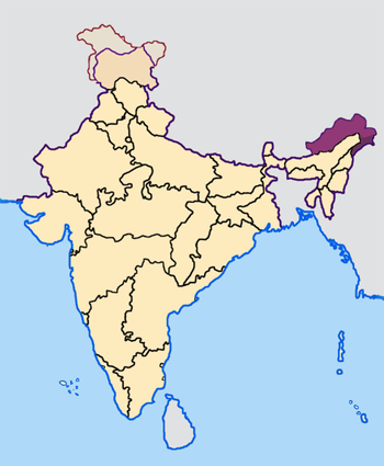
Position matched with OpenStreetMap; the dashed outline shows its mapped extent. Other numbered pins are the day's other places — tap one to open it.
Why in the news
Arunachal Pradesh is in focus following reported clearance of 26 roads under ICBR-III to strengthen strategic border connectivity. The Union Government has not officially announced the programme’s details; the reported clearance should therefore not be treated as an official programme announcement.
Read the full analysis: ICBR-III: China Border Roads, Last-Mile Connectivity and Strategic Trade-offsCapital
Itanagar
Statehood
20 February 1987
International neighbours
Bhutan, China and Myanmar
Adjoining Indian states
Assam and Nagaland
Principal drainage basin
Brahmaputra
Location
- Lies north of Assam in north-eastern India.
- Adjoins Bhutan to the west, China’s Tibet region to the north, and Myanmar to the east.
- Shares interstate boundaries with Assam and Nagaland.
- Extends from the Tawang region in the west to the Patkai hill region in the south-east.
Bordering countries
- Bhutan
- China
- Myanmar
Key features
- Eastern Himalaya
- High mountain ranges and deeply dissected valleys dominate much of the state.
- Mishmi Hills
- These rugged hills occupy the eastern part of the state around the Dibang and Lohit valleys.
- Patkai Hills
- The south-eastern hill belt forms part of the mountainous frontier with Myanmar.
- Brahmaputra drainage
- The Siang, Subansiri, Kameng, Dibang and Lohit drain towards the Brahmaputra system.
- Siang river
- The Yarlung Tsangpo enters Arunachal Pradesh from Tibet and is known as the Siang.
- Sela Pass
- A high mountain pass on the route between the West Kameng and Tawang regions.
Flora, fauna & ecology
- Altitudinal vegetation
- Vegetation ranges from tropical and subtropical forests in lower valleys to temperate forests and alpine vegetation at higher elevations.
- Namdapha
- Namdapha National Park and Tiger Reserve protects extensive forests in Changlang district near Myanmar.
- Pakke
- Pakke Tiger Reserve lies in the Eastern Himalayan foothills and is known for its hornbills.
- Climate
- Monsoonal rainfall and strong elevation differences produce marked variations in temperature and vegetation.
History & significance
- Much of the present state was administered as the North-East Frontier Agency before becoming the Union Territory of Arunachal Pradesh in 1972.
- The region was a major theatre of the 1962 India–China war.
UPSC angle
- Map international neighbours, adjoining Indian states and the eastern sector of the India–China boundary dispute.
- Trace the Yarlung Tsangpo–Siang–Brahmaputra river system and distinguish its major tributaries.
- Link border infrastructure with strategic mobility, difficult mountain terrain and disaster vulnerability.
- Locate Namdapha and Pakke and relate Eastern Himalayan biodiversity to altitude and monsoonal rainfall.
Also locate on your map
- Tawang
- Sela Pass
- Itanagar
- Namdapha National Park
- Pakke Tiger Reserve
- Bhutan
- Assam
Test yourself
Q1. Which of the following sets correctly lists all the countries bordering Arunachal Pradesh?
Q2. The Siang river in Arunachal Pradesh forms part of which major river system?
Sources
Background maps and imagery © Esri and partners (English labels); place positions checked with OpenStreetMap (ODbL). Boundaries are for study reference only. Prepared by Pragnya IAS Academy for exam revision.