
Black Sea
South-eastern Europe–Western Asia
Black Sea: India signals readiness to help establish food corridors
The Black Sea is a largely enclosed sea between south-eastern Europe and western Asia. It connects to the Mediterranean through the Bosporus, Sea of Marmara and Dardanelles.
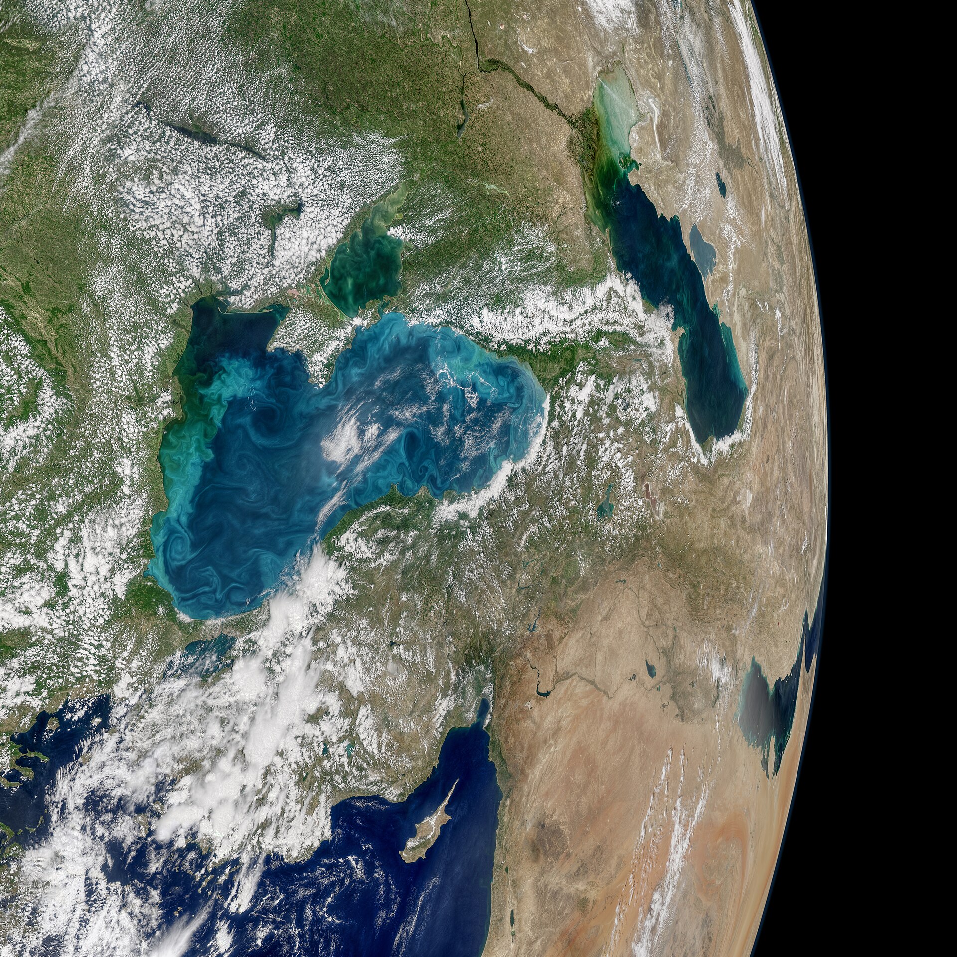
Position matched with OpenStreetMap; the dashed outline shows its mapped extent. Other numbered pins are the day's other places — tap one to open it.
Why in the news
Following a phone call with Prime Minister Narendra Modi, Ukrainian President Volodymyr Zelenskyy said India was ready to help establish food corridors. India's engagement with Ukraine and Russia includes potential facilitation of Black Sea food shipments, but no concluded corridor agreement has been reported.
Read the full analysis: India’s Ukraine Peace Diplomacy: Black Sea Food Corridors and Security GuaranteesCoastal countries
Six
South-western gateway
Bosporus
Link to Sea of Azov
Kerch Strait
Major delta
Danube Delta
Major Ukrainian port
Odesa
Major Romanian port
Constanța
Location
- Lies north of Türkiye, south of Ukraine and west of Georgia and the Caucasus.
- Romania and Bulgaria occupy its western shores; Russia borders its north-eastern shores.
- The Bosporus links its south-western end to the Sea of Marmara, which connects through the Dardanelles to the Aegean Sea.
- The Kerch Strait connects its north-eastern sector to the Sea of Azov.
Bordering countries
- Türkiye
- Bulgaria
- Romania
- Ukraine
- Russia
- Georgia
Key features
- Restricted marine connection
- Its connection with the Mediterranean passes through two narrow Turkish straits and the Sea of Marmara.
- Major river inflows
- The Danube, Dniester and Dnieper drain into the Black Sea.
- Continental shelf
- A broad, shallow shelf occupies the north-western sector, contrasting with the deep central basin.
- Water stratification
- Less saline surface water overlies denser, saltier deep water, limiting vertical mixing.
- Two-layer exchange
- Through the Bosporus, surface water flows towards the Sea of Marmara while saltier water enters the Black Sea below.
- Crimean Peninsula
- Crimea projects into the northern Black Sea; the Kerch Strait lies at its eastern end.
Flora, fauna & ecology
- Anoxic deep waters
- Much of the deep water lacks dissolved oxygen and contains hydrogen sulphide, restricting most marine animal life to upper waters.
- Phytoplankton
- Seasonal phytoplankton blooms can produce conspicuous turquoise swirls visible in satellite imagery.
- Delta wetlands
- The Danube Delta supports extensive reed beds, wetlands and important habitats for migratory birds.
History & significance
- Known in classical antiquity as the Euxine Sea, its coasts hosted Greek trading settlements.
- The 1936 Montreux Convention governs passage through the Turkish Straits, including differentiated rules for merchant vessels and warships.
UPSC angle
- Prelims mapping: identify the six littoral countries and distinguish the Bosporus, Dardanelles and Kerch Strait.
- GS I physical geography: examine salinity stratification, restricted water exchange and deep-water anoxia.
- GS II international relations: connect India's diplomatic engagement with the Russia–Ukraine conflict and maritime access.
- GS III food security: assess how disruption of Black Sea export routes affects grain supply chains.
Also locate on your map
- Bosporus
- Sea of Marmara
- Dardanelles
- Aegean Sea
- Kerch Strait
- Sea of Azov
- Danube Delta
- Odesa
Test yourself
Q1. Which sequence correctly traces the maritime route from the Black Sea to the Aegean Sea?
Q2. Consider the following countries: 1. Romania 2. Georgia 3. Armenia 4. Bulgaria. Which of these have a coastline on the Black Sea?
Sources
- The Hindu: Ahead of Abu Dhabi peace talks, Modi speaks to Zelenskyy; Jaishankar speaks to Lavrov
- The Hindu: What to know about upcoming peace talks involving Russian, Ukrainian and U.S. officials
- Indian Express: India ready to help set up food corridors, says Ukrainian President Zelenskyy after phone call with PM Modi
- Indian Express: India News Highlights, 9 November 2026: PM Modi speaks to Zelenskyy, reaffirms India's support for peaceful resolution
Background maps and imagery © Esri and partners (English labels); place positions checked with OpenStreetMap (ODbL). Boundaries are for study reference only. Prepared by Pragnya IAS Academy for exam revision.