
Record Pacific Heat and El Niño: ENSO Dynamics, Forecast Risks and India’s Preparedness
Revise the static topic: UPSC Environment notes
In short: Record sea-surface temperatures in the equatorial Pacific have raised concerns about an exceptionally strong El Niño in 2026–27. The supplied report cites an 83% likelihood of a strong to very strong event, but its eventual strength and consequences for India remain uncertain because monsoon rainfall depends on several interacting climatic drivers.
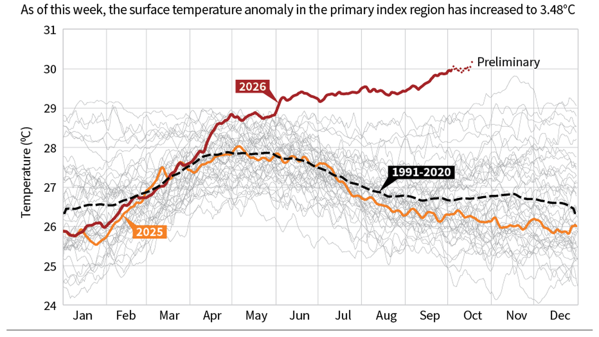
Record equatorial Pacific warmth has heightened concern about a strong El Niño in 2026–27, but its eventual intensity and effects on India’s monsoon remain uncertain.
Image: The Hindu
Why in news
The Hindu reports that the Niño 3.4 region’s sea-surface temperature exceeded 30°C on October 5 for the first time in its recorded history. It also reports a projected peak temperature anomaly of 3.8°C for the 2026–27 El Niño, making forecast interpretation and climate preparedness particularly important.
83%
Reported likelihood of strong to very strong El Niño
3.8°C
Reported projected peak anomaly for 2026–27
>30°C
Reported Niño 3.4 temperature on October 5
2.6°C
2015–16 three-month average anomaly cited
2.4°C
1997–98 three-month average anomaly cited
2.1°C
1982–83 three-month average anomaly cited
Background
The El Niño–Southern Oscillation, or ENSO, is a recurring interaction between the tropical Pacific Ocean and the atmosphere. Its phases are El Niño, La Niña and neutral conditions. Normally, easterly trade winds push warm surface water towards the western Pacific, while colder water rises in the eastern equatorial Pacific. El Niño involves anomalous warming of the central and eastern equatorial Pacific coupled with changes in winds, pressure and tropical convection. The Southern Oscillation refers to the associated atmospheric pressure variation, while the Walker circulation describes the tropical east–west circulation that connects these oceanic and atmospheric processes.
What the report establishes—and what remains a forecast
The supplied report describes record Pacific warmth and cites the US NOAA Climate Prediction Center as assigning an 83% likelihood to a strong to very strong El Niño. It also reports a projected peak anomaly of 3.8°C for 2026–27. These are forecast claims, not observations of the event’s eventual peak.
The article identifies 1982–83, 1997–98 and 2015–16 as very strong historical events and gives their three-month average anomalies. However, the excerpt does not specify the model, reference baseline or averaging period behind the projected 3.8°C peak. A rigorous historical ranking requires comparable indices, baselines and averaging periods.
- The reported 83% probability concerns the strong to very strong category; it is not the probability of drought in India.
- The supplied excerpt does not quantify the probability that the event will become the strongest on record.
- A projected peak must not be presented as an already observed temperature anomaly.
Infographic
Observe
Track Pacific temperatures, subsurface heat, winds and convection.
Interpret
Separate daily records, sustained anomalies and forecast probabilities.
Localise
Assess monsoon drivers, crop stages and district water conditions.
Prepare
Activate crop, water, heat-health and power contingency measures.
Update
Revise decisions as forecasts and observed conditions evolve.
AI-assisted infographic by Pragnya IAS Academy, based on the cited sources.
ENSO dynamics: how Pacific warming reorganises weather
During El Niño development, weakened trade winds allow warm surface water to spread eastwards. Reduced cold-water upwelling and changes in the thermocline favour further surface warming in the central and eastern equatorial Pacific. As tropical convection shifts, atmospheric circulation changes can reinforce the weakening of trade winds.
This mutually reinforcing ocean–atmosphere interaction is called the Bjerknes feedback. Changes in tropical heating can influence atmospheric circulation far beyond the Pacific through teleconnections, affecting rainfall, temperature and storm patterns in distant regions.
- The Niño 3.4 region is a central-equatorial Pacific monitoring area used to assess ENSO conditions.
- Ocean warming alone does not fully describe ENSO; atmospheric coupling is also important.
- El Niño and La Niña are phases of natural climate variability, not synonyms for global warming and global cooling.
Why record heat does not eliminate forecast uncertainty
An absolute sea-surface temperature, such as the reported value above 30°C, differs from a temperature anomaly, which measures departure from a reference climatology. Daily records also differ from sustained seasonal anomalies. High absolute temperatures therefore cannot, by themselves, establish an ENSO event’s final strength.
Forecasts depend on initial ocean conditions, subsurface heat, wind variability, ocean–atmosphere coupling and model performance. Ensemble forecasts explore a range of possible outcomes rather than provide a guaranteed trajectory. Predictability also varies by season; the spring predictability barrier is a recognised difficulty in forecasting ENSO across boreal spring.
Long-term warming raises the background temperature on which ENSO operates. However, the supplied report does not establish how much of the projected event’s strength is attributable to human-induced climate change, nor does it prove that every future El Niño will be stronger.
- Track agreement across models and successive forecast updates rather than rely on a single projected peak.
- Assess both oceanic indicators and atmospheric responses before drawing conclusions about event evolution.
- Separate confidence in ENSO development from confidence in regional rainfall impacts.
India’s exposure: rainfall, agriculture and water security
El Niño is generally associated with an increased risk of weaker Indian summer monsoon rainfall, but the relationship is not deterministic. Indian Ocean conditions, including the Indian Ocean Dipole, intraseasonal monsoon variability and regional weather systems can modify the outcome. A positive Indian Ocean Dipole may sometimes moderate adverse influences, but it is not a guaranteed safeguard.
For agriculture, rainfall timing and distribution can matter as much as the seasonal total. Delayed sowing, prolonged dry spells and moisture stress during sensitive crop stages can reduce yields or increase irrigation demand. Reservoir storage, soil moisture and groundwater conditions determine how strongly a rainfall shortfall translates into water insecurity.
A forecast peak during 2026–27 does not by itself establish the outcome of India’s next summer monsoon. The event’s persistence into the relevant season must be assessed. Summer monsoon relationships should also not be mechanically applied to the northeast monsoon, which has different regional and seasonal linkages.
- Water stress can intensify competition among drinking-water supply, irrigation, industry and ecosystems.
- Greater irrigation demand can increase groundwater extraction and agricultural electricity demand.
- Rainfed farmers and communities with limited storage or adaptive capacity face greater vulnerability.
- A below-normal seasonal rainfall outlook does not rule out localised heavy rain or flooding.
Preparedness: translate probabilities into decisions
India should treat the reported forecast as a risk signal requiring closer monitoring, not as a declaration of inevitable drought. India Meteorological Department outlooks and agrometeorological advisories should be combined with reservoir levels, groundwater status, soil moisture and district-level crop conditions.
Preparedness should follow a trigger-based approach: intensify monitoring first, activate locally suitable crop and water contingency measures as evidence strengthens, and review measures as forecasts evolve. Low-regret interventions can reduce vulnerability even if the event develops differently from the current projection.
- Prepare district-specific crop advisories covering sowing windows, suitable varieties and contingency crops.
- Review reservoir operations while balancing drinking water, irrigation, ecological needs and flood management.
- Strengthen groundwater demand management and irrigation scheduling rather than relying only on additional pumping.
- Integrate heat-health preparedness with farm advisories, electricity planning and public communication.
- Explain forecast probabilities clearly to avoid both complacency and alarm.
| Indicator | Meaning | Interpretation limit |
|---|---|---|
| Absolute sea-surface temperature | Actual temperature of the ocean surface | A record value alone does not establish ENSO intensity. |
| Temperature anomaly | Departure from a reference climatological temperature | Comparisons require compatible baselines and averaging periods. |
| Atmospheric coupling | Coherent changes in winds, pressure and convection alongside ocean warming | Surface temperature alone cannot describe the full coupled system. |
| Ensemble probability | Forecast likelihood derived from a range of possible model outcomes | It is neither certainty nor a direct probability of Indian drought. |
| Regional impact outlook | Assessment of likely rainfall or temperature effects in a particular region | It depends on season, other climate drivers and local conditions. |
- 1. Equatorial Pacific trade winds weaken.
- 2. Warm surface water spreads eastwards and cold-water upwelling weakens.
- 3. Central and eastern equatorial Pacific warming shifts tropical convection.
- 4. Atmospheric circulation changes reinforce ocean warming through coupled feedback.
- 5. Teleconnections alter regional rainfall and temperature probabilities.
- 6. Other climate drivers and local vulnerability shape India’s actual impacts.
1982–83
The source cites a very strong El Niño with a three-month average anomaly of 2.1°C.
1997–98
The source cites a very strong El Niño with a three-month average anomaly of 2.4°C.
2015–16
The source cites a very strong El Niño with a three-month average anomaly of 2.6°C.
August 22, 2026
The report states that the average surface temperature of the world’s oceans beyond the poles reached a record 21.18°C.
October 5, 2026
The report states that Niño 3.4 sea-surface temperature exceeded 30°C for the first time in its recorded history.
2026–27 outlook
The source reports a projected El Niño peak anomaly of 3.8°C; the eventual peak remains a forecast outcome.
Significance, challenges & way forward
Significance
- The reported Pacific warming provides a warning signal for climate-sensitive sectors, even though regional outcomes remain uncertain.
- ENSO monitoring connects ocean science with agricultural planning, water allocation and disaster preparedness.
- Advance risk assessment can support protective action before rainfall deficits translate into crop losses or drinking-water stress.
- The episode highlights the need to assess natural climate variability against a warmer climatic background.
Challenges
- The supplied excerpt does not provide the methodology needed to independently assess the projected 3.8°C peak.
- A forecast of global ENSO intensity cannot directly establish district-level rainfall, crop losses or water shortages.
- Seasonal rainfall totals may conceal damaging dry spells, uneven distribution and localised extremes.
- Groundwater dependence and weak storage buffers can magnify the consequences of rainfall variability.
- Sensational descriptions of event strength can obscure forecast uncertainty and encourage inappropriate decisions.
Way forward
- Use successive official forecasts and multiple ocean–atmosphere indicators to update risk assessments.
- Combine seasonal outlooks with shorter-range forecasts and local water and crop monitoring.
- Develop transparent preparedness triggers linked to rainfall deficits, storage conditions and crop-stage vulnerability.
- Promote locally suitable crop diversification, soil-moisture conservation and efficient irrigation alongside water-use planning.
- Coordinate meteorological, agricultural, water, health and power authorities through shared contingency plans.
- Communicate what is observed, what is projected and what remains uncertain in every public advisory.
Key terms
- ENSO
- A coupled tropical Pacific ocean–atmosphere phenomenon with El Niño, La Niña and neutral phases.
- Niño 3.4
- A central-equatorial Pacific monitoring region whose sea-surface temperature anomalies are widely used to assess ENSO.
- Southern Oscillation
- The atmospheric pressure variation over the tropical Pacific associated with ENSO.
- Walker circulation
- Tropical east–west atmospheric circulation involving rising air, upper-level flow, sinking air and surface winds.
- Thermocline
- The ocean layer in which temperature decreases rapidly with depth.
- Bjerknes feedback
- A reinforcing interaction among equatorial Pacific temperatures, trade winds and ocean structure.
- Teleconnection
- A climatic link through which changes in one region influence weather patterns in distant regions.
- Indian Ocean Dipole
- A pattern of contrasting sea-surface temperature anomalies between the western and eastern equatorial Indian Ocean.
Link with static syllabus
Prelims practice MCQs
Q1. With reference to El Niño dynamics, consider the following statements: 1. Weakening equatorial Pacific trade winds can favour eastward movement of warm surface water. 2. El Niño typically involves enhanced cold-water upwelling in the eastern equatorial Pacific. 3. Changes in tropical convection can influence weather in regions far from the Pacific. Which of the statements given above are correct?
Q2. A forecast assigns a high probability to a strong to very strong El Niño. Which of the following is the most appropriate inference for India?
Q3. Consider the following pairs: 1. Southern Oscillation — Atmospheric pressure variation associated with ENSO 2. Thermocline — Ocean layer with a rapid temperature decrease with depth 3. Bjerknes feedback — Reinforcing interaction between equatorial Pacific ocean conditions and atmospheric circulation Which of the pairs given above are correctly matched?
Q4. With reference to interpreting Pacific temperature records, consider the following statements: 1. Absolute sea-surface temperature and sea-surface temperature anomaly are different measures. 2. A single daily temperature record is sufficient to establish the final strength of an ENSO event. 3. Historical comparisons of anomalies require attention to reference baselines and averaging periods. Which of the statements given above are correct?
Mains practice questions
GS 3 · 15 marks · 250 words
An exceptionally strong El Niño forecast is a warning signal, not a deterministic prediction of drought in India. Explain and suggest a climate-preparedness framework for agriculture and water security.
Frequently asked questions
Does the reported 83% likelihood mean India has an 83% chance of drought?
No. The reported probability concerns a strong to very strong El Niño, not Indian drought; regional rainfall depends on several interacting climate drivers.
Why does a Niño 3.4 temperature above 30°C not establish El Niño strength by itself?
It is an absolute temperature, whereas ENSO assessment considers anomalies relative to a reference climatology, their persistence and the associated atmospheric response.
Has the 2026–27 El Niño already become the strongest recorded event?
The supplied material does not establish that conclusion. It reports a projected peak and a high likelihood of a strong event, while the eventual intensity remains uncertain.
What should India prioritise immediately?
India should strengthen forecast monitoring, district crop advisories and water contingency planning. Action should respond to evolving local conditions rather than assume uniform nationwide impacts.
Sources
Analysis prepared by the Pragnya IAS Academy current-affairs desk with AI assistance from the cited reports. Verify figures with the original sources.
Turn current affairs into marks
Join Pragnya IAS Academy's mentorship for daily answer-writing evaluation on stories like this — classroom programmes from a trusted name in IAS coaching in Hyderabad.