

A Nadi is a small Johad, usually constructed on naturally occurring patches of thick clay where water cannot seep into ground, thus providing drinkable water to village cattle.
Credit: Amar singh kangarot · CC BY-SA 4.0 · source

Nagarjuna Sagar dam with all Crest gates closed
Credit: iMahesh · CC BY-SA 4.0 · source
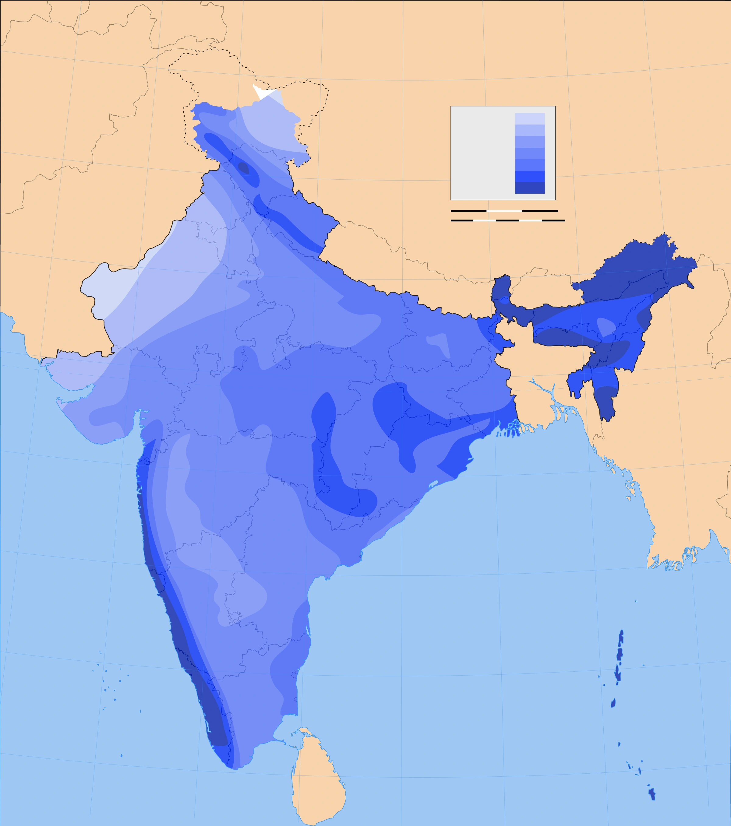
Map study
Annual rainfall distribution: compare the western coast and northeast with the dry northwest and rain-shadow interior. Historical climatological reference, not a current-year forecast.
- Read the source legend, scale and reference period before comparing regions.
- Connect spatial patterns to the processes discussed in this topic; this map is a study reference, not live operational data.
Credit: Planemad · CC BY-SA 3.0 · sourceConverted to WebP on an opaque white background; proportionally resized without cropping. Original cartography and legend retained.
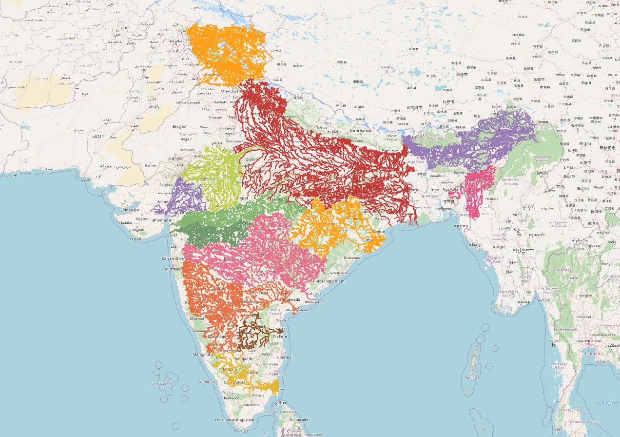
Map study
India river basins: distinguish watershed divides from state boundaries; compare east-flowing and west-flowing drainage.
- Read the source legend, scale and reference period before comparing regions.
- Connect spatial patterns to the processes discussed in this topic; this map is a study reference, not live operational data.
Credit: Heinz OSM · ODbL · sourceConverted to WebP on an opaque white background; proportionally resized without cropping. Original cartography and legend retained.
1. Availability, distribution and water accounting
Water resources comprise surface water, groundwater and water stored as snow and ice. Rivers, lakes, wetlands and reservoirs provide surface supplies, while aquifers store groundwater. These sources are connected: infiltration recharges aquifers, and groundwater discharge sustains many rivers during the dry season. Consequently, groundwater pumping can reduce river baseflow even without direct abstraction from a river.
India receives approximately 4,000 billion cubic metres of annual precipitation, including snowfall, but this is not equivalent to usable freshwater. Evapotranspiration, rapid runoff, terrain, geological conditions and the timing of rainfall limit availability. The Central Water Commission’s 2019 reassessment estimated average annual water resources at about 1,999 BCM. This basin-scale estimate and the conventional utilisable-resource estimate of 1,123 BCM measure different things and should not be confused.
Rainfall is highly uneven. The western slopes of the Western Ghats and much of northeastern India receive abundant rainfall, whereas western Rajasthan and the rain-shadow interiors of the Deccan receive much less. Concentration of rain into a few months means that floods and seasonal scarcity can occur in the same region. Tamil Nadu also receives substantial rainfall during the October–December northeast monsoon.
Water stress reflects pressure on available water relative to demand. Under the commonly used Falkenmark indicator, annual availability below 1,700 cubic metres per person indicates stress, below 1,000 indicates scarcity, and below 500 indicates absolute scarcity. National averages conceal basin-level shortages, unreliable access and pollution. Physical availability therefore differs from the amount that people can safely and affordably obtain.
- BCM means billion cubic metres; one BCM equals one cubic kilometre.
- Renewable water is replenished through the hydrological cycle; it does not imply unlimited or uniformly available supply.
- Water withdrawal is abstraction from a source; consumptive use is the portion not promptly returned for reuse, especially through evapotranspiration.
2. Surface water, groundwater and water quality
Himalayan rivers generally receive both precipitation and snow or glacier melt, although the contribution varies greatly between basins. Peninsular rivers depend more strongly on seasonal rainfall and commonly exhibit larger seasonal flow variations. Reservoirs redistribute runoff across seasons and support irrigation, electricity generation and urban supply. Their effective capacity can decline through sedimentation, while evaporation causes additional losses.
The Indo-Gangetic-Brahmaputra alluvial plains contain extensive aquifers with considerable groundwater-storage potential. In much of peninsular India, crystalline hard rocks store groundwater mainly in weathered layers and fractures. Such aquifers often have limited and spatially variable storage. A borewell’s depth alone therefore does not guarantee a sustainable yield. Coastal aquifers face seawater intrusion when excessive pumping lowers freshwater pressure.
Groundwater over-extraction is particularly serious in parts of Punjab, Haryana, Rajasthan and other intensively cultivated or urbanised areas. The stage of groundwater extraction expresses annual extraction as a percentage of annual extractable groundwater resources. An assessment unit with extraction exceeding 100 per cent is classified as over-exploited. Nationally comfortable averages can coexist with severe local depletion.
Quality problems further reduce usable supplies. Arsenic contamination occurs in parts of the Ganga-Brahmaputra alluvial region; excessive fluoride occurs in several hard-rock terrains. Salinity affects coastal and arid areas, while nitrate contamination commonly reflects fertiliser use, sewage or other human inputs. Pathogens, untreated wastewater and industrial effluents also threaten water security. Geogenic contamination requires suitable treatment or alternative sources, not merely deeper drilling.
- An unconfined aquifer has a water table as its upper boundary; a confined aquifer lies beneath a relatively impermeable layer.
- Recharge structures must suit local geology and receive sufficiently clean water.
- Wetlands help moderate floods, retain pollutants and support biodiversity, but cannot absorb unlimited waste.
Preparing a local water-security plan
- 1. Map the watershed, aquifers and water infrastructure
- 2. Estimate seasonal availability, demand and water quality
- 3. Identify depletion, pollution and access gaps
- 4. Combine recharge and ecosystem restoration with demand management
- 5. Agree on allocation, maintenance and monitoring responsibilities
- 6. Review groundwater levels, service reliability and ecological outcomes
3. Agriculture, irrigation and competing demands
Irrigation reduces dependence on uncertain rainfall and enables multiple cropping, but its sustainability depends on crop choice, delivery systems and drainage. Canals serve extensive command areas but may suffer from conveyance losses and unequal distribution between head-end and tail-end farmers. Wells provide flexible, farmer-controlled irrigation, while tanks remain important in several peninsular landscapes.
Water-intensive paddy and sugarcane cultivation in water-stressed locations can create a mismatch between agricultural demand and local ecology. Assured procurement, electricity pricing, market access and perceived production risks influence farmers’ decisions. Crop diversification therefore requires reliable markets and institutional support rather than conservation appeals alone. Millets, pulses and suitable oilseeds can reduce irrigation demand in appropriate agroclimatic settings.
Drip irrigation applies water near the root zone; sprinklers distribute it under pressure. Both can improve application efficiency when appropriately designed. However, field-level savings do not automatically become basin-level savings: farmers may expand irrigated area, while reduced seepage may also reduce groundwater recharge. Excess irrigation without drainage can cause waterlogging and salinisation, lowering soil productivity.
- Demand management includes irrigation scheduling, soil-moisture conservation, mulching and agronomically appropriate crop choices.
- Environmental flows sustain river ecosystems and downstream functions; rivers cannot be treated solely as irrigation channels.
- Treated wastewater can substitute for freshwater in selected industrial and agricultural uses when quality standards and health safeguards are met.
| Source or method | Principal advantage | Important constraint |
|---|---|---|
| Canals | Large command-area coverage | Unequal distribution; waterlogging where drainage is inadequate |
| Wells and tubewells | Flexible, on-demand irrigation | Aquifer depletion and pumping-energy costs |
| Tanks | Local storage and multiple community uses | Siltation, encroachment and variable inflows |
| Drip irrigation | Targeted root-zone application | Capital costs, maintenance and possible clogging |
| Sprinkler irrigation | Useful across varied terrain and suitable soils | Wind drift, evaporation and energy requirements |
4. Institutions, laws and major programmes
Entry 17 of the State List covers water supplies, irrigation, canals, drainage, embankments, water storage and water power, subject to Entry 56 of the Union List. Entry 56 concerns regulation and development of inter-State rivers and river valleys when Parliament declares Union control expedient in the public interest. Article 262 enables parliamentary provision for adjudication of inter-State water disputes and exclusion of court jurisdiction over specified disputes.
The Inter-State River Water Disputes Act, 1956 provides a statutory dispute-resolution framework. The Water (Prevention and Control of Pollution) Act, 1974 establishes mechanisms for preventing and controlling water pollution through pollution-control boards. The Central Water Commission deals with surface-water assessment and related technical functions; the Central Ground Water Board assesses and studies groundwater resources.
Pradhan Mantri Krishi Sinchayee Yojana, launched in 2015, promotes irrigation access and water-use efficiency through its programme architecture. Jal Jeevan Mission, launched in 2019, seeks functional household tap connections in rural areas, with emphasis on adequate quantity, prescribed quality and regular supply. Atal Bhujal Yojana promotes community-led groundwater management in selected water-stressed areas of seven states. Namami Gange combines pollution abatement with river-conservation measures.
- Atal Bhujal Yojana covers selected areas in Gujarat, Haryana, Karnataka, Madhya Pradesh, Maharashtra, Rajasthan and Uttar Pradesh.
- Jal Shakti Abhiyan: Catch the Rain promotes rainwater conservation and harvesting.
- A tap connection is an access indicator; lasting service also depends on source sustainability, maintenance and water quality.
5. Conservation and integrated management
Integrated water-resources management coordinates land, water and ecosystem management at an appropriate hydrological scale. Watershed treatment uses contour bunds, vegetative measures, check dams and soil conservation to slow runoff and improve infiltration. Traditional systems—including johads in Rajasthan, ahar-pynes in Bihar and eris in Tamil Nadu—illustrate locally adapted water management.
Urban priorities include protecting lakes and floodplains, restoring drainage channels, reducing distribution leakage and treating sewage. Floodplain encroachment and impermeable surfaces increase runoff and reduce recharge. Climate change adds uncertainty through changing rainfall intensity, drought risk and cryospheric changes. Resilience therefore requires diversified sources, credible water budgets, drought planning and transparent monitoring rather than dependence on a single large project.
- Supply augmentation and demand reduction should be planned together.
- River-linking proposals require basin-specific evaluation of ecological effects, displacement, costs and assumptions about surplus water.
- Participatory aquifer management connects individual pumping decisions with the shared nature of groundwater.
Real-world case studies
Johad restoration in Alwar, Rajasthan
Community action supported by Tarun Bharat Sangh restored johads and undertook catchment treatment in villages of Alwar district. These measures improved local water retention and groundwater recharge and contributed to revival of flows in the Arvari catchment. The lesson is that small structures work best with catchment protection and collective management.
Chennai’s 2019 water crisis
Poor rainfall and depleted major reservoirs intensified Chennai’s water shortage in 2019, increasing dependence on tankers and emergency supplies. The crisis highlighted the vulnerability created by limited source diversity, groundwater pressure and degradation of urban water bodies. Desalination can supplement coastal-city supply, but entails energy costs and brine-management concerns.
Previous year questions
UPSC Mains 2019 · GS-I
What is water stress? How and why does it differ regionally in India?
- Define water stress as pressure of demand on available usable water.
- Explain rainfall seasonality, aridity, aquifer characteristics and basin differences.
- Connect irrigation patterns, urbanisation, pollution and infrastructure with regional stress.
- Distinguish national availability from local and seasonal access.
Practice questions
Practice MCQ 1
Consider the following statements: 1. Extensive alluvial aquifers occur in the Indo-Gangetic plains. 2. Groundwater in crystalline hard rocks is commonly stored in weathered and fractured zones. 3. Excessive pumping in coastal aquifers can cause seawater intrusion. Which statements are correct?
- A. 1 and 2 only
- B. 2 and 3 only
- C. 1 and 3 only
- D. 1, 2 and 3
Practice MCQ 2
Which constitutional provision specifically addresses adjudication of disputes relating to waters of inter-State rivers or river valleys?
- A. Article 249
- B. Article 262
- C. Article 280
- D. Article 312
Practice MCQ 3
Consider the following statements: 1. Higher irrigation efficiency necessarily reduces total water consumption at basin level. 2. Groundwater pumping can diminish a river’s dry-season baseflow. 3. Artificial recharge should consider the quality of recharge water. Which statements are correct?
- A. 1 only
- B. 1 and 2 only
- C. 2 and 3 only
- D. 1, 2 and 3
Mains practice · India’s water insecurity is as much a problem of management as of physical scarcity. Discuss with reference to agriculture, groundwater and urbanisation. Suggest a basin-sensitive strategy. (250 words)
- Introduce seasonal and regional differences in water availability.
- Examine cropping incentives, inefficient irrigation, groundwater extraction and pollution.
- Discuss leakage, encroachment and inadequate sewage treatment in cities.
- Recommend aquifer budgeting, crop diversification, local conservation and wastewater reuse.
- Include environmental flows, inter-State cooperation and equitable access.
- Conclude with measurable outcomes: reliable services, improved quality and stable groundwater levels.
Further reading
- NCERT, India: People and Economy, Class XII: Water Resources.
- NCERT, Contemporary India–II, Class X: Water Resources.
- Central Water Commission: Reassessment of Water Availability in India Using Space Inputs, 2019, and Water and Related Statistics.
- Central Ground Water Board: National Compilation on Dynamic Ground Water Resources of India and aquifer-mapping publications.
- Ministry of Jal Shakti: Jal Jeevan Mission and Atal Bhujal Yojana official guidelines.
- India Code: Constitution of India; Inter-State River Water Disputes Act, 1956; Water (Prevention and Control of Pollution) Act, 1974.
Preparing for UPSC Civil Services? Get classroom teaching, answer-writing evaluation and mentorship at Pragnya IAS Academy, Ashok Nagar — see why aspirants choose us for IAS coaching in Hyderabad.