

Shikara on the Sukhna Lake in Chandigarh, India.
Credit: Original: Biswarup Ganguly Derivative work: UnpetitproleX · CC BY 3.0 · source

Landscapes of Western Ghats captured on our way to the summit of Mullayyanagiri Betta
Credit: iMahesh · CC BY-SA 4.0 · source
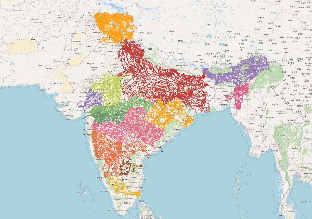
Map study
India river basins: distinguish watershed divides from state boundaries; compare east-flowing and west-flowing drainage.
- Read the source legend, scale and reference period before comparing regions.
- Connect spatial patterns to the processes discussed in this topic; this map is a study reference, not live operational data.
Credit: Heinz OSM · ODbL · sourceConverted to WebP on an opaque white background; proportionally resized without cropping. Original cartography and legend retained.
1. Meaning, boundaries and drainage hierarchy
A watershed is a hydrologically connected area whose surface runoff converges at a specified outlet, called a pour point. Rain falling on opposite sides of a drainage divide normally reaches different drainage systems. Watershed boundaries are therefore delineated mainly from relief, whereas village, district and State boundaries are administrative. One watershed may cross several administrative units, making coordinated planning necessary.
Terminology requires care. NCERT describes a watershed as the boundary separating drainage basins and notes the conventional distinction between large river basins and smaller watersheds. In watershed-management literature, however, watershed normally means the contributing drainage area itself. Catchment area and drainage basin are frequently used as near-synonyms. No universal size threshold separates all these terms.
Drainage units are nested: a small hillside catchment contributes to a tributary sub-basin, which forms part of a larger river basin. Selecting a different outlet changes the area being considered. The Ganga basin includes numerous tributary catchments, while a farm pond may receive runoff from only a small local catchment. Endorheic basins drain internally into lakes or depressions rather than reaching the sea.
- Divide: the boundary between adjacent drainage areas.
- Outlet: the point through which drainage leaves the selected watershed.
- Interfluve: land between adjacent stream valleys; its higher parts may form a divide.
- Watershed area is not the same as command area, which is the land that an irrigation system can serve.
2. Delineation and hydrological behaviour
On a topographic map, delineation begins by identifying the outlet and tracing the surrounding ridgelines using contours and spot heights. The boundary crosses contours approximately at right angles as it follows the steepest ascent towards the ridge and should not cross contributing stream channels except at the selected outlet. Digital elevation models, GIS and remote sensing allow systematic mapping of flow direction, flow accumulation and drainage boundaries.
A simplified water balance is P = Q + ET + ΔS, where precipitation equals runoff or discharge, evapotranspiration and change in storage. Where significant, groundwater exchanges and human transfers must also be included. Water infiltrating the soil can be retained as soil moisture, return to the atmosphere, move laterally towards streams or percolate deeper to recharge groundwater. Infiltration and recharge are therefore not identical.
Storm response depends on rainfall intensity and duration, antecedent soil moisture, slope, soil permeability, geology, vegetation and drainage connectivity. Intense rain exceeding infiltration capacity produces infiltration-excess runoff; saturated soils can generate saturation-excess runoff. Steep slopes, compacted surfaces and impervious urban cover commonly accelerate runoff. Vegetation and soil organic matter often improve infiltration and reduce erosion, though increased vegetation can also increase evapotranspiration.
Compact basins may concentrate runoff more quickly than elongated basins under comparable conditions. Drainage density is total channel length divided by basin area. Higher density often accompanies relatively impermeable terrain and rapid runoff, but it is influenced by climate, relief and mapping scale. Groundwater movement follows hydraulic gradients, so aquifer recharge areas and groundwater divides can differ from surface catchments.
- Runoff coefficient: the fraction of rainfall appearing as runoff for a defined period or event.
- Time of concentration: time required for runoff from the hydraulically most distant part of a catchment to reach its outlet.
- Baseflow: the slower contribution to streamflow, commonly supplied by groundwater and other delayed storage.
Integrated watershed-planning cycle
- 1. Identify the outlet and delineate the watershed
- 2. Map slopes, soils, drainage, aquifers, land use and households
- 3. Prepare a participatory water budget and identify vulnerabilities
- 4. Plan suitable ridge-to-valley treatments and demand-management measures
- 5. Implement works with community oversight and safeguards
- 6. Monitor hydrological and livelihood outcomes and maintain assets
3. Indian geographical setting and significance
The Western Ghats form a major drainage divide in Peninsular India. Many short, steep rivers descend westwards towards the Arabian Sea, while major systems such as the Krishna and Cauvery drain extensive areas eastwards towards the Bay of Bengal. The Narmada and Tapi are important west-flowing exceptions within Peninsular drainage, occupying structurally controlled valleys. River direction should therefore not be inferred solely from a general regional slope.
Himalayan watersheds combine steep relief, active erosion, landslides and, in many headwaters, snow or glacier contributions. Roads, slope cutting and poorly managed construction can increase sediment delivery and instability. In the semi-arid Deccan, strongly seasonal rainfall, variable soils and widespread hard-rock aquifers make soil-moisture conservation and locally appropriate recharge measures especially important.
Watersheds connect upstream activities with downstream consequences. Deforestation, mining, overgrazing and exposed agricultural soils can increase sediment loads, while sewage and agrochemicals affect water quality. Conversely, indiscriminate upstream impoundment can reduce downstream flows. Urban catchments illustrate the same principle: paving and encroachment on natural drainage or wetlands can increase flood peaks even without an equivalent increase in rainfall.
- Internal drainage occurs in parts of western Rajasthan, including catchments feeding saline lakes such as Sambhar.
- Watershed management is relevant to drought resilience, reservoir sedimentation, drinking-water security and flood moderation.
- The hydrological unit is useful for planning, but interventions must also respect aquifer characteristics and downstream water requirements.
| Term | Basis | Key distinction |
|---|---|---|
| Watershed or catchment | Runoff reaching a common outlet | Defined principally by surface topography |
| Drainage divide | Boundary separating drainage areas | A boundary, not the contributing area |
| River basin | Drainage area of a river system | Contains nested tributary catchments |
| Aquifer | Geological formation storing and transmitting groundwater | May extend across surface-water divides |
| Irrigation command area | Land served by an irrigation system | Need not coincide with a natural catchment |
4. Watershed development: principles and interventions
Integrated watershed development seeks to conserve soil and water while sustaining production and livelihoods. The conventional ridge-to-valley approach begins with upper slopes and progressively treats lower slopes, drainage lines and cultivated areas. Stabilising upper catchments first can reduce sediment entering structures downstream. This is a planning principle rather than a requirement to build the same sequence of structures everywhere.
Upper slopes may require protection from excessive grazing, assisted natural regeneration, suitable vegetation and carefully designed trenches. Agricultural land may benefit from contour cultivation, bunding, mulching, vegetative barriers and improved soil organic matter. Gully plugs, check dams and other drainage-line treatments can slow runoff and trap sediment. Farm ponds and percolation structures require site-specific assessment of soils, geology, water availability, safety and downstream effects.
Supply augmentation alone cannot ensure water security. Recharge gains may be cancelled by additional pumping, expansion of irrigated area or a shift towards water-intensive crops. Effective programmes therefore combine water budgeting, appropriate crop choices, irrigation scheduling and groundwater management with physical works. Micro-irrigation can improve application efficiency, but basin-wide savings depend on whether total consumptive use actually declines.
Community participation is central because costs and benefits are unevenly distributed. Landless households may depend on commons, while well owners capture much of the benefit from groundwater recharge. Watershed institutions should include women, smallholders and disadvantaged groups, establish maintenance arrangements, and protect access to shared resources. Outcomes should be assessed through soil loss, crop stability, groundwater trends, vegetation condition and livelihood benefits, not merely the number of structures completed.
- Match measures to slope, rainfall, soil depth, aquifer conditions and land use.
- Avoid treating every infiltration structure as an effective groundwater-recharge structure.
- Retain safe overflow pathways and account for extreme rainfall.
- Assess downstream flows, ecosystem needs and equity alongside local benefits.
5. Indian programmes and examination linkages
The Integrated Watershed Management Programme was launched in 2009–10 by consolidating earlier watershed programmes. In 2015–16, it became the Watershed Development Component of Pradhan Mantri Krishi Sinchayee Yojana, commonly called WDC-PMKSY. The Department of Land Resources, Ministry of Rural Development, is its central administering department. This is an important institutional distinction because other components of PMKSY involve different ministries and departments.
WDC-PMKSY 2.0 was approved for 2021–22 to 2025–26 with a physical target of 49.50 lakh hectares and an indicative Central outlay of ₹8,134 crore. Its guidelines emphasise productive use of rainwater, land restoration, livelihood improvement and more effective watershed institutions. These figures describe the approved programme framework, not necessarily completed achievements.
MGNREGA can support eligible water-conservation, drought-proofing and land-development works, enabling convergence with watershed plans. Atal Bhujal Yojana provides a related but distinct example of community-led groundwater management in selected water-stressed areas of seven States. For examination purposes, distinguish the surface-drainage focus of watershed delineation from aquifer-based groundwater planning, while recognising the need to integrate both.
- Prelims traps: watershed versus divide; catchment versus command area; infiltration versus recharge; local efficiency versus basin-wide water savings.
- Mains linkages: rainfed agriculture, climate adaptation, decentralised governance, commons management and upstream–downstream equity.
Real-world case studies
Sukhomajri, Haryana
Beginning in the 1970s, watershed work in Sukhomajri in the Shivalik foothills combined small water-harvesting structures, catchment protection and community arrangements. Reduced grazing pressure and improved vegetation helped address erosion associated with sedimentation in Chandigarh’s Sukhna Lake catchment. The case demonstrates why shared benefits and rules for common lands matter as much as engineering.
Hiware Bazar, Maharashtra
Hiware Bazar in Ahmednagar district, now officially Ahilyanagar, is known for watershed treatment, vegetation restoration and community water planning. Its experience highlights the value of linking recharge and soil conservation with decisions about cropping and water demand. Replication requires attention to local geology, rainfall, social inclusion and sustained village institutions rather than simply copying structures.
Previous year questions
No source-linked PYQ is available here yet. Use the practice questions below.
Practice questions
Practice MCQ 1
With reference to watershed delineation, consider the following statements: 1. A surface-water divide generally follows topographic highs. 2. Groundwater divides invariably coincide with surface-water divides. 3. Changing the selected outlet can change the delineated catchment area. Which of the statements given above are correct?
- A. 1 and 2 only
- B. 1 and 3 only
- C. 2 and 3 only
- D. 1, 2 and 3
Practice MCQ 2
Which one of the following best explains the ridge-to-valley approach in watershed development?
- A. Diverting all ridge runoff into the lowest reservoir
- B. Constructing large dams before treating the catchment
- C. Progressively treating upper slopes, lower slopes and drainage lines to reduce erosion and manage runoff
- D. Afforesting every part of a watershed irrespective of existing land use
Practice MCQ 3
Consider the following statements about watershed programmes in India: 1. WDC-PMKSY is administered centrally by the Department of Land Resources. 2. Eligible watershed-related works can receive support through MGNREGA. 3. Building recharge structures necessarily ensures a sustained rise in groundwater levels. Which of the statements given above are correct?
- A. 1 only
- B. 2 and 3 only
- C. 1 and 2 only
- D. 1, 2 and 3
Mains practice · Watershed development is as much an exercise in water-demand management and collective action as in soil and water conservation. Discuss with Indian examples. (250 words)
- Define watershed and explain its value as a planning unit.
- Describe site-specific ridge-to-valley measures and their soil-moisture and erosion benefits.
- Explain why recharge must be linked with pumping, crop choices and water budgeting.
- Discuss community institutions, maintenance, commons and equitable benefit sharing.
- Use Sukhomajri and Hiware Bazar as illustrations.
- Conclude with aquifer integration, downstream safeguards and outcome-based monitoring.
Further reading
- NCERT, India: Physical Environment, Class XI, chapter on Drainage System.
- NCERT, India: People and Economy, Class XII, chapter on Water Resources.
- Department of Land Resources, Guidelines for New Generation Watershed Development Projects: WDC-PMKSY 2.0.
- Central Ground Water Board, Master Plan for Artificial Recharge to Groundwater in India, 2020.
- India-WRIS, official river-basin and water-resources information.
Preparing for UPSC Civil Services? Get classroom teaching, answer-writing evaluation and mentorship at Pragnya IAS Academy, Ashok Nagar — see why aspirants choose us for IAS coaching in Hyderabad.