

This is a photo of ASI monument number
Credit: Bhajish Bharathan · CC BY-SA 4.0 · source

Excavated ruins of Mohenjo-daro, with the Great Bath in the foreground and the granary mound in the background
Credit: Saqib Qayyum · CC BY-SA 3.0 · source
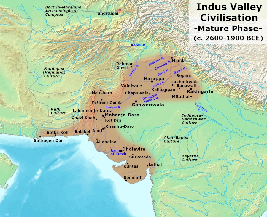
Map study
Mature Harappan civilisation, c. 2600–1900 BCE: settlement distribution, not the territory of a single empire.
- Read the source date and legend before interpreting territorial extent.
- Compare core regions, neighbouring powers and geographic barriers; historical borders and influence are approximate and changed over time.
Credit: Avantiputra7 · CC BY-SA 3.0 · sourceConverted to WebP on an opaque white background; proportionally resized without cropping. Original cartography and legend retained.
1. Understanding the geographical extent
The name Indus Valley Civilization reflects the early discovery of its major cities in the Indus drainage region. Harappan Civilization, derived from the type-site Harappa, better accommodates its much wider distribution. Archaeological remains occur across alluvial plains, desert margins, coastal tracts and foothill zones. The Indus and its tributaries formed a major axis, but Gujarat and the Ghaggar-Hakra region were also substantial settlement areas.
The geographical spread is commonly estimated at about 1.3 million square kilometres, making it one of the most extensive Bronze Age cultural zones. However, this figure depends on which sites and phases are included. Shared pottery, seals, weights, bricks and craft traditions indicate cultural interaction; they do not establish that every settlement belonged to one centrally administered state.
Chronology is essential when reading distribution maps. Early Harappan developments are generally dated to about 3300–2600 BCE, the Mature Harappan urban phase to 2600–1900 BCE, and Late Harappan developments to roughly 1900–1300 BCE, with regional variation. A map combining all three phases shows a wider cumulative distribution than a map of mature cities alone.
- For Prelims, distinguish archaeological distribution, mature urban settlement and political control.
- Modern national and state boundaries are location aids, not ancient cultural boundaries.
Timeline
c. 3300–2600 BCE
Early Harappan regional cultures developed across several north-western settlement zones.
c. 2600–1900 BCE
Mature Harappan urbanism and extensive interregional exchange connected the Indus plains, adjoining inland regions and Gujarat.
c. 1900–1300 BCE
Late Harappan regionalisation involved urban decline in some areas and continued or expanding settlement in others.
2. Core river systems and inland settlement clusters
The Indus plain linked northern agricultural areas with the lower river basin and Arabian Sea. Harappa lies near an old course of the Ravi in Punjab, Pakistan. Mohenjo-daro stands in the Indus plain of Sindh, Pakistan. Other important Sindh sites include Chanhudaro and Kot Diji. Riverine environments supplied fertile soils, water and communication routes, although floods and shifting channels also affected settlement.
The Ghaggar-Hakra corridor contains a dense archaeological distribution extending through Haryana, northern Rajasthan and Cholistan in Pakistan. Important sites include Kalibangan in Rajasthan, Banawali and Rakhigarhi in Haryana, and Ganweriwala in Cholistan. Rakhigarhi is among the largest known Harappan sites. Settlement numbers must be interpreted carefully because many recorded sites belong to different periods and were not occupied simultaneously.
The identification of the Ghaggar-Hakra with the Vedic Sarasvati remains debated. Archaeology, sediment studies and palaeochannel research do not justify assuming that one large perennial river sustained every settlement throughout the mature phase. Rainfall, seasonal streams, groundwater and local water management could support habitation. Rivers also changed course, so the nearest present-day channel may not reproduce the ancient landscape.
Towards the east, Harappan-related settlements reached the upper Ganga-Yamuna doab. Alamgirpur, near the Hindon in Meerut district, Uttar Pradesh, is conventionally used as the eastern limit. This does not mean that the civilization occupied the entire Gangetic plain.
Method for interpreting a Harappan distribution map
- 1. Identify the archaeological phase shown
- 2. Locate the Indus, Ghaggar-Hakra and Gujarat clusters
- 3. Separate major cities from smaller settlements and trading outposts
- 4. Relate sites to waterways, coasts and resources
- 5. Distinguish settlement extent from overseas exchange
3. Gujarat, the coast and the north-western frontier
Gujarat formed a major southern and maritime zone rather than an insignificant fringe. Settlements were distributed across Kachchh, Saurashtra and adjoining mainland areas. Dholavira, on Khadir Bet in the Great Rann of Kachchh, illustrates urban adaptation to a water-scarce environment. Surkotada is another important Kachchh site, while Lothal, near the Gulf of Khambhat, demonstrates links between inland production and coastal exchange.
Coastal Gujarat offered access to marine shells, fisheries and sea routes. Lothal’s large brick-lined basin is conventionally interpreted as a dockyard, although its precise function has been debated. Present shorelines should not be projected unchanged into the third millennium BCE: sedimentation and changing waterways have altered connections between settlements and the sea.
Westward, Harappan sites occurred along the Makran coast of present-day Pakistan. Sutkagen-dor, near the Dasht River and close to the Iranian border, is conventionally treated as the westernmost site. Sotka Koh, near Pasni, also helps demonstrate the significance of the Makran corridor. These settlements are associated with coastal communication linking the Indus region with areas farther west.
Shortugai, near the Kokcha River in north-eastern Afghanistan, was a distant Harappan trading settlement. Its position provided access to the lapis lazuli-producing region of Badakhshan and routes through Central Asia. It should be understood as evidence of long-distance commercial reach, not proof of continuous Harappan occupation across all intervening territory.
| Direction | Site | Present location | Geographical association |
|---|---|---|---|
| North | Manda | Jammu and Kashmir, India | Chenab; Himalayan foothill margin |
| East | Alamgirpur | Uttar Pradesh, India | Hindon; upper Ganga-Yamuna doab |
| West | Sutkagen-dor | Balochistan, Pakistan | Dasht River; Makran region |
| South | Daimabad | Maharashtra, India | Pravara; Late Harappan association |
4. Conventional limits and chronological cautions
Standard examination summaries often identify Manda, Alamgirpur, Sutkagen-dor and Daimabad as the northern, eastern, western and southern limits respectively. This is a useful memory aid, but it combines sites with different archaeological histories. Manda, near Akhnoor in Jammu and Kashmir, lies on the Chenab and marks the northern foothill margin in this conventional scheme.
Daimabad, on the Pravara River in Maharashtra, is cited as the southern limit because of its Late Harappan cultural association. It should not be presented as a southern counterpart of Mature Harappan Mohenjo-daro. Alamgirpur is also commonly discussed in connection with later Harappan expansion. For a question specifically asking about Mature Harappan urban geography, phase-specific evidence is more important than memorising extreme points.
After about 1900 BCE, many large urban centres declined or changed character, while smaller settlements continued or expanded in some eastern and southern regions. This was a process of regional transformation rather than the simultaneous disappearance of all communities. Consequently, the geographical contraction of urbanism could coexist with the dispersal of Harappan traditions into new areas.
- Direction questions: Manda—north; Alamgirpur—east; Sutkagen-dor—west; Daimabad—south.
- Always check whether the question concerns all Harappan phases or the mature urban phase alone.
5. Why this distribution matters
The civilization’s extent reveals an economy connecting complementary environments. Alluvial plains supported agriculture; Gujarat supplied marine resources and access to maritime routes; neighbouring uplands supplied or channelled minerals and stone. Copper from regions including Rajasthan and materials such as carnelian and lapis lazuli circulated through exchange networks. Resource sources and trading partners must nevertheless be distinguished from Harappan settlements.
Broad similarities in material culture suggest sustained interaction across considerable distances. At the same time, differences in building materials, food production and water management show regional adaptation. Dholavira’s extensive use of stone and reservoirs contrasts with the familiar brick-built urban landscapes of the Indus plain.
For map-based preparation, organise sites by modern location, river or environmental setting, and archaeological phase. Avoid treating every site as a major city. Overseas contacts with Oman, Bahrain and Mesopotamia demonstrate exchange beyond the settlement zone; the presence of Harappan objects abroad does not by itself place those regions within the civilization’s geographical extent.
Real-world case studies
Dholavira: urbanism beyond perennial river plains
Dholavira in Gujarat was inscribed on UNESCO’s World Heritage List in 2021. Located between the seasonal Mansar and Manhar streams, it developed reservoirs and water-control structures. The site demonstrates why Harappan geography cannot be explained solely through large perennial rivers.
Shortugai: a distant commercial outpost
Excavations at Shortugai in Afghanistan revealed characteristic Harappan material culture. Its location near routes accessing Badakhshan illustrates the relationship between settlement and valuable raw materials. It also highlights the distinction between a distant outpost and a continuously occupied territorial zone.
Previous year questions
No source-linked PYQ is available here yet. Use the practice questions below.
Practice questions
Practice MCQ 1
Which pair of Harappan sites is located in present-day Haryana?
- A. Kalibangan and Alamgirpur
- B. Rakhigarhi and Banawali
- C. Manda and Harappa
- D. Dholavira and Surkotada
Practice MCQ 2
Consider the following statements: 1. Daimabad’s inclusion as a southern limit requires attention to its Late Harappan association. 2. Every site on a composite Harappan map was occupied during the mature urban phase. 3. Shortugai provides evidence of Harappan commercial connections with north-eastern Afghanistan. Which statements are correct?
- A. 1 and 2 only
- B. 2 and 3 only
- C. 1 and 3 only
- D. 1, 2 and 3
Practice MCQ 3
Which sequence correctly identifies the conventional northern, eastern, western and southern limits of Harappan distribution?
- A. Manda—Alamgirpur—Sutkagen-dor—Daimabad
- B. Harappa—Kalibangan—Shortugai—Lothal
- C. Manda—Rakhigarhi—Dholavira—Daimabad
- D. Shortugai—Alamgirpur—Sutkagen-dor—Surkotada
Mains practice · The geographical distribution of the Harappan Civilization reflects both cultural integration and ecological diversity. Discuss. Answer in 150 words.
- Identify the Indus plains, Ghaggar-Hakra corridor, Gujarat and peripheral outposts.
- Connect shared seals, weights and craft traditions with interregional interaction.
- Contrast alluvial agriculture, coastal resources and semi-arid water management.
- Use Dholavira and Shortugai as examples.
- Distinguish archaeological extent from political unity and note chronological variation.
Further reading
- NCERT, Themes in Indian History, Part I: Bricks, Beads and Bones.
- NCERT, Our Pasts—I: In the Earliest Cities.
- UNESCO World Heritage Centre: Dholavira: a Harappan City.
- Archaeological Survey of India: excavation reports and site information on Harappan settlements.
- Upinder Singh, A History of Ancient and Early Medieval India: From the Stone Age to the 12th Century.
Preparing for UPSC Civil Services? Get classroom teaching, answer-writing evaluation and mentorship at Pragnya IAS Academy, Ashok Nagar — see why aspirants choose us for IAS coaching in Hyderabad.