
Türkiye
Western Asia and south-eastern Europe
Türkiye: Promoting a voluntary COP31 electrification pledge
Türkiye is a transcontinental country spanning Anatolia in western Asia and Eastern Thrace in south-eastern Europe. The Turkish Straits connect the Black Sea with the Aegean Sea through the Sea of Marmara.
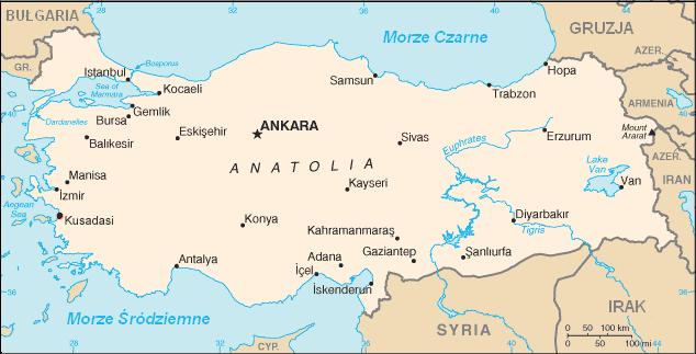
Position matched with OpenStreetMap; the dashed outline shows its mapped extent. Other numbered pins are the day's other places — tap one to open it.
Why in the news
Türkiye is promoting a voluntary electrification pledge at COP31. It seeks to raise electricity's share of global energy demand from around 20% to 35% by 2035.
Read the full analysis: COP31 Electrification Pledge: Climate Finance, Equity and India’s Policy AutonomyCapital
Ankara
Largest city
Istanbul
Highest point
Mount Ararat
Largest lake
Lake Van
Major rivers rising in Türkiye
Euphrates and Tigris
Location
- Most of its territory lies on the Anatolian peninsula in western Asia; Eastern Thrace lies in Europe.
- It lies south of the Black Sea, north of the Mediterranean Sea and east of the Aegean Sea.
- The Bosporus, Sea of Marmara and Dardanelles separate its European and Asian territories.
- Its eastern frontier adjoins the South Caucasus and Iran, while Syria and Iraq lie along its southern frontier.
Bordering countries
- Greece
- Bulgaria
- Georgia
- Armenia
- Azerbaijan, through its Nakhchivan exclave
- Iran
- Iraq
- Syria
Key features
- Anatolian Plateau
- An elevated interior region enclosed by mountain belts along the northern and southern margins.
- Pontic Mountains
- Extend broadly parallel to the Black Sea coast in northern Türkiye.
- Taurus Mountains
- Form a major mountain belt along southern Anatolia, overlooking the Mediterranean coast.
- Turkish Straits
- The Bosporus links the Black Sea to the Sea of Marmara; the Dardanelles links Marmara to the Aegean Sea.
- Eastern highlands
- Contain Mount Ararat and the headwaters of the Euphrates and Tigris rivers.
- Tectonic setting
- The North Anatolian and East Anatolian fault systems make Türkiye highly earthquake-prone.
Flora, fauna & ecology
- Coastal climate
- Aegean and Mediterranean coastal areas have hot, dry summers and mild, wetter winters.
- Black Sea ecosystems
- The humid northern coastal belt supports extensive forests.
- Interior ecosystems
- The continental interior includes semi-arid steppe, with cold winters and dry summers.
History & significance
- Istanbul, formerly Constantinople, served as a capital of the Byzantine and Ottoman empires.
- The Republic of Türkiye was proclaimed in 1923, with Ankara as its capital.
UPSC angle
- Map Türkiye's eight land neighbours, especially its short border with Azerbaijan's Nakhchivan exclave.
- Trace the Black Sea–Bosporus–Marmara–Dardanelles–Aegean route and its maritime significance.
- Connect Anatolian fault systems with plate movements and earthquake hazards.
- Link the COP31 pledge to electrification, clean power supply and climate mitigation; distinguish electricity's energy-demand share from renewable electricity's generation share.
- Locate the Euphrates–Tigris headwaters and examine downstream water interdependence with Syria and Iraq.
Also locate on your map
- Black Sea
- Bosporus
- Sea of Marmara
- Dardanelles
- Aegean Sea
- Nakhchivan
- Lake Van
- Euphrates–Tigris basin
Test yourself
Q1. Which of the following countries shares a land border with Türkiye through an exclave?
Q2. Which sequence correctly traces a vessel's passage from the Black Sea towards the Aegean Sea?
Sources
- The Hindu: EU climate chief Wopke Hoekstra warns 'expectations low' from COP31 summit
- The Hindu: COP31: Can negotiators finally deliver results? | The Hindu explains
- The Hindu: COP31 opens as climate and geopolitical pressures mount
- Indian Express: COP31: Why climate summits still matter, even as the world misses its targets
Background maps and imagery © Esri and partners (English labels); place positions checked with OpenStreetMap (ODbL). Boundaries are for study reference only. Prepared by Pragnya IAS Academy for exam revision.